All Activity
- Past hour
-

Occasional Thoughts on Climate Change
Typhoon Tip replied to donsutherland1's topic in Climate Change
I found this to be an interesting article... https://phys.org/news/2026-04-climate-decline-hot-cold-extreme.html (https://link.springer.com/article/10.1007/s00704-026-06200-3) Dr. John R. Christy, Alabama State Climatologist (retired); professor of atmospheric and Earth science at The University of Alabama in Huntsville I'm curious if this may ever be corroborated by other's findings. **Also ... bear in mind the study is regarding "extremes" It doesn't address the longer term climate averages rising. Those are created by the daily stuffing, the vast majority of which are not extreme, per se. I can see a pathway toward reducing the "extremeness" of extreme events, while the en masse the bulk temperatures result warmer over time. It would come from increasing the water vapor content. This is basic Meteorology: in order to store more water vapor, requires more energy. Raising the global energy level ( planetary energy imbalance ) by way of packing green house gases faster than the background geological processes can compensate, raises temperature. GW incarnate. This provides the necessary energy to evaporates more water and keep it in the atmosphere. Excluding the fact that the oceans have absorbed 90+% of the total warming since the IR (industrial revolution). I would be really keenly interested in a DP comparison variation of Dr Christy is finding, if that might also have correlative relationship with any rises in integrated Dew Point (relative to sigma levels) since 1899. The idea being, as DP ambience becomes more and dense over time, it has a modulating impact on ambient temperature. This is low-bar Meteorology. Such that extremes of hot and cold are modulated lower due to the complex thermodynamics of storing more energy in water vapor. When the ambient cold sourcing has high WV content it's just not going to be as cold, because it's holding more thermal latency. Contrasting, as the DP rises the temp always comes down, that is because therms are "borrowed" from the kinetic temperature in order to keep the water in gaseous form. 98/80 has equivalent energy to 115/68 ..etc. -
I must be the only human in existence who wishes for stormy weather when he goes away lol
-
We got some rain..not alot but everything soaked, had to use wipers coming into work.
-
Jeff, I have a question out of curiosity. It may just be me, but it seems like almost all severe weather threats in East TN take place in the late evening/overnight hours. Afternoon severe weather events appear to be somewhat rare. Is there any truth to this, and what causes this?
-
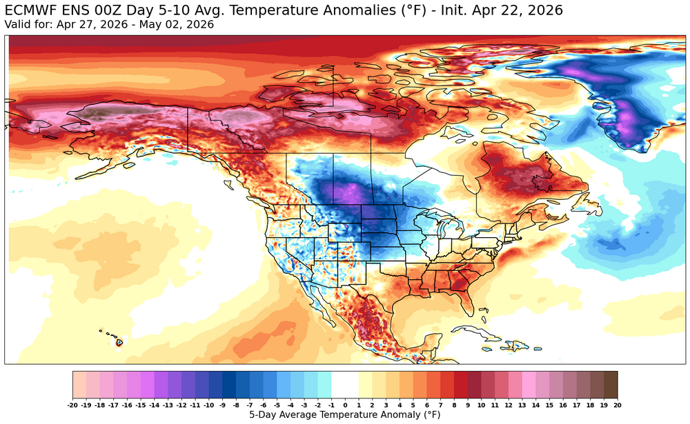
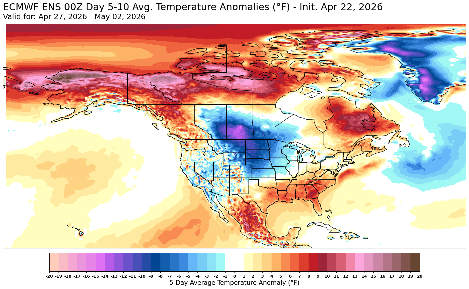
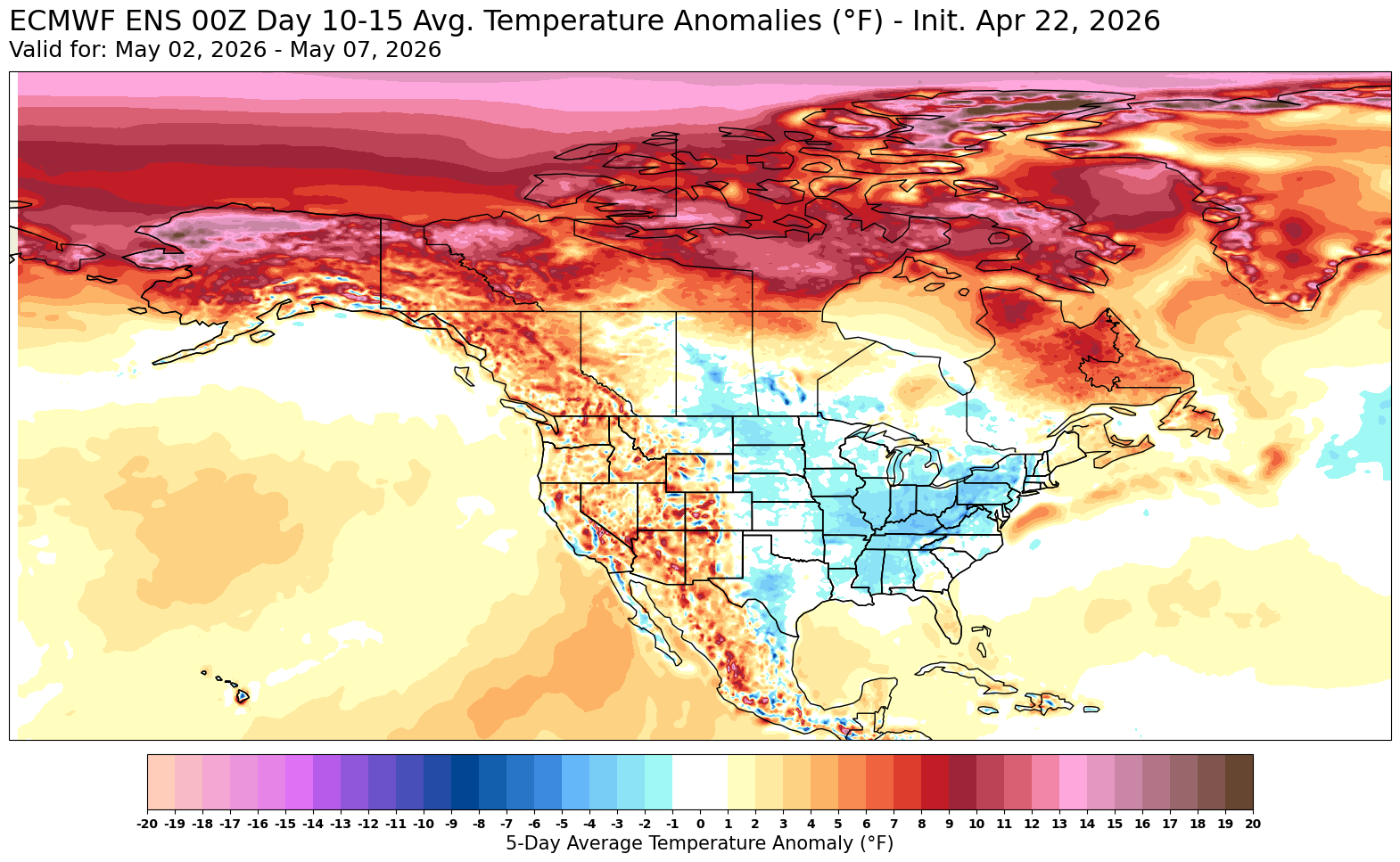
At least for the next few weeks, it looks like the warmer days will be in the 70s rather than the 90s. Plenty of blocking setting up which should cap the higher end temperature potential. These impressive temperature swings seem to have increased in frequency starting around January 2005 with how quickly the record warmth reversed to significantly colder. But the warmest temperatures during the swings most of the time is more impressive than the coldest readings. Climatological Data for NY CITY CENTRAL PARK, NY - January 2005 Click column heading to sort ascending, click again to sort descending. Sum 1160 781 - - 1035 0 4.67 15.3 - Average 37.4 25.2 31.3 -2.4 - - - - 3.5 Normal 39.5 27.9 33.7 - 970 0 3.64 2005-01-01 60 40 50.0 14.8 15 0 0.00 0.0 0 2005-01-02 50 37 43.5 8.5 21 0 0.00 0.0 0 2005-01-03 58 49 53.5 18.7 11 0 0.45 0.0 0 2005-01-04 51 46 48.5 13.8 16 0 0.06 0.0 0 2005-01-05 46 35 40.5 6.0 24 0 0.28 T 0 2005-01-06 41 34 37.5 3.1 27 0 0.62 0.0 0 2005-01-07 42 36 39.0 4.8 26 0 T T 0 2005-01-08 41 35 38.0 3.9 27 0 0.59 T 0 2005-01-09 40 33 36.5 2.6 28 0 0.00 0.0 0 2005-01-10 48 39 43.5 9.7 21 0 0.00 0.0 0 2005-01-11 40 35 37.5 3.8 27 0 0.25 T 0 2005-01-12 39 35 37.0 3.4 28 0 0.12 0.0 0 2005-01-13 59 38 48.5 15.0 16 0 0.00 0.0 0 2005-01-14 66 34 50.0 16.6 15 0 1.03 0.0 0 2005-01-15 34 26 30.0 -3.4 35 0 0.00 0.0 0 2005-01-16 31 27 29.0 -4.3 36 0 0.00 0.0 0 2005-01-17 28 18 23.0 -10.3 42 0 0.03 0.5 T 2005-01-18 18 9 13.5 -19.7 51 0 T T 0 2005-01-19 26 9 17.5 -15.7 47 0 0.03 0.8 0 2005-01-20 30 20 25.0 -8.2 40 0 0.00 0.0 0 2005-01-21 20 9 14.5 -18.6 50 0 0.00 0.0 0 2005-01-22 25 6 15.5 -17.6 49 0 0.93 8.5 0 2005-01-23 26 9 17.5 -15.7 47 0 0.25 5.3 13 2005-01-24 24 8 16.0 -17.2 49 0 T T 14 2005-01-25 33 20 26.5 -6.7 38 0 0.00 0.0 13 2005-01-26 37 17 27.0 -6.2 38 0 0.01 T 13 2005-01-27 18 9 13.5 -19.8 51 0 0.00 0.0 13 2005-01-28 22 5 13.5 -19.9 51 0 0.00 0.0 11 2005-01-29 34 15 24.5 -8.9 40 0 0.00 0.0 11 2005-01-30 38 24 31.0 -2.5 34 0 0.02 0.2 11 2005-01-31 35 24 29.5 -4.1 35 0 0.00 0.0 11

-
This was a really interesting seasonal update. Would love to know their thinking for such a small max in the Apps, lee and piedmont regions, but I assume they’re counting on a lot of diurnal convection and high elevation initiation. Sign me up. Other than snow, nothing beats a 90° day getting its knees taken out by some drifters off the mountains, leading to a nice rain cooled 75° evening on the porch. .
-
We clear for the entire time I think. Which is fine by me.
-
Looks Steined through next Tuesday, except SW zones. So much for the awful stretch some called for
-
Sanibel is a great place. Hopefully you’ll catch a random storm or two while there
-

2026-2027 El Nino
40/70 Benchmark replied to Stormchaserchuck1's topic in Weather Forecasting and Discussion
1957 is best subsurface map in terms of placement AND intensity of subsurface warm pool. It's also a good polar analog in terms of solar and QBO. -
Celts were 14pt favorites for gm2 so quite a shock in gambling land. Flyers tonight...
-
2026-2027 El Nino
40/70 Benchmark replied to Stormchaserchuck1's topic in Weather Forecasting and Discussion
-
This is from Sat (25) and Tue / Wed next week
-
about 1/10 of an inch of rain here.
-
2026-2027 El Nino
40/70 Benchmark replied to Stormchaserchuck1's topic in Weather Forecasting and Discussion
-
Records: Highs: EWR: 87 (1985) NYC: 86 (2001) LGA: 85 (2001) JFK: 82 (2001) Lows: EWR: 32 (1947) NYC: 28 (1875) LGA: 33 (1947) JFK: 36 (2021) Historical: 1857:The Genesee Suspension Bridge in Genesee, NY, collapsed under the weight of 12 inches of wet snow weighing 19 pounds per cubic foot. Snow fell to a depth of 48 inches at Liberty in the Catskills. (Ref. Wilson Wx. History) 1883 - An outbreak of tornadoes from Louisiana to Kansas claimed the lives to 200 persons. One of the tornadoes destroyed the town of Beauregard MS. (David Ludlum) 1978: Lightning sometimes strikes tents. In this case, a tent containing some sleeping Girl Scouts was hit by lightning as they were camping at DeGray Lake in Arkansas. Two of the Girl Scouts suffered minor burns. 1980 - A record April heat wave sent the mercury up to the 100 degree mark in Iowa. (The Weather Channel) 1987 - Fifteen cities in the southeastern U.S. reported new record high temperatures for the date. The afternoon high of 96 degrees at Pensacola FL established a record for the month of April. (The National Weather Summary) 1988 - Heavy snow fell over northern Nebraska, with 15 inches reported at Mullen. Heavy snow also blanketed the mountains of northern Arizona, with 16 inches reported at Munds Park. (The National Weather Summary) (Storm Data) 1989 - Twenty-seven cities in the central U.S. reported record high temperatures for the date. The high of 96 degrees at Omaha was an April record, and the high of 100 degrees at Lubbock TX equalled their record for April. Hill City KS and Liberal KS tied for honors as the hot spot in the nation with afternoon highs of 103 degrees. (The National Weather Summary) 1990 - Thunderstorms produced severe weather from the Southern and Central High Plains to northwest Florida during the afternoon and evening. Thunderstorms produced wind gusts to 67 mph at Gillette WY, hail two inches in diameter west of Roswell NM, and deluged Cheyenne OK with 8.68 inches of rain leaving some parts of the town under five feet of water. Temperatures reached the low 90s in the north central U.S. Chamberlain SD and Pickstown SD tied Presidio TX for honors as the hot spot in the nation with afternoon highs of 94 degrees. (The National Weather Summary) (Storm Data) 1991:On April 20th and 21st Boston had 3.32 inches precipitation the greatest in a 24 hours for April. (Ref. NOAA Boston Weather Events) 1999: A one million dollar air charter Bowling 727 flew into large hail. Although the plane and it 66 occupants landed safely, the aircraft was declared a total loss. 2002: A tornado moved across Wayne County, in southeast Illinois. The tornado passed through the southern part of Fairfield with F3 intensity winds. One person was killed in a mobile home west of Wayne City. 42 people were injured, 13 critically. A total of 35 homes were destroyed, and 16 received major damage. (Ref. Wilson Wx. History) 2003: Tropical Storm Ana became the first Atlantic tropical storm since records began in 1871 to form during the month April. Maximum sustained winds reached 55 mph. Starting as a non-tropical area of low pressure on the 18th about 210 miles south-southwest of Bermuda, it was classified as a sub-tropical storm early on the 20th, it gained full tropical characteristics near 0000 UTC on the 21st, developing an "eye" feature. 2011 - Lambert International Airport in St. Louis experiences extensive damage as it is hit by a group of tornados, blowing out windows in the main terminal and tearing the roof off Concourse C. Five people were taken to the hospital with minor injuries from shattered glass and flying debris.
-
nice^
-

Central PA Spring 2026 Discussion/Obs Thread
Mount Joy Snowman replied to Voyager's topic in Upstate New York/Pennsylvania
Bet everything you have on @Jns2183's daughter winning every Science Fair medal to be had in the years to come -
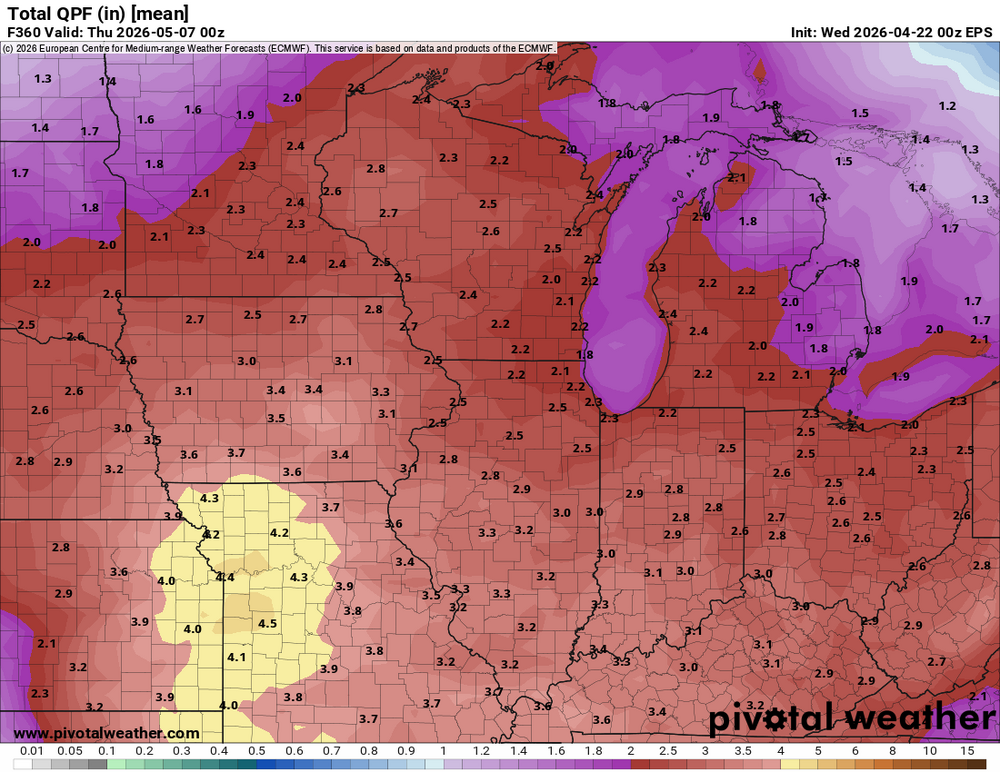
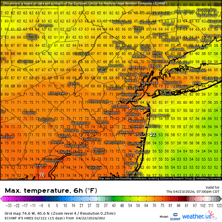
48 / 41 rain / showers moving through more focused in the northern areas into NYC. Clear out and warm up for 36 - 48 hours with Thursday the nicest day / warmest and driest of the next 10. Low - mid 70s. Weekend loosk cool / wet Sat into sun with >0.5 inches and potentially >1.0 for the area. Trough / much into the east . Moderation towards the second week of May with ridge coming east.
- 779 replies
-
- 1
-

-
- april showers bring may..
- rain
- (and 2 more)
-

Central PA Spring 2026 Discussion/Obs Thread
Jns2183 replied to Voyager's topic in Upstate New York/Pennsylvania
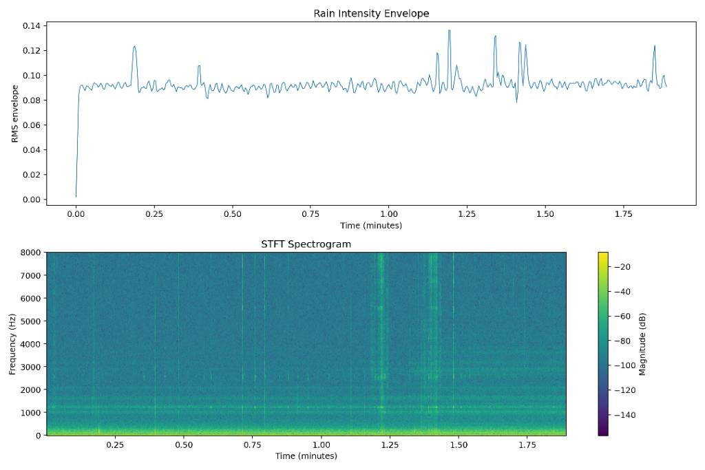
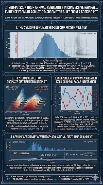
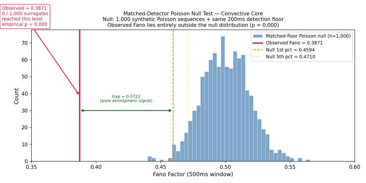
My daughter's science project we picked was recording the sound of rain underneath a pot on a deck. She got an A and I've had way to much fun since with the data. Sent from my SM-S731U using Tapatalk
-
0.00 as well . Most didn’t get much of anything.
-
Boston still gonna win the series, but happy to see the Sixers come back strong for game 2. Flyers look unbelievable against the Pens!
-
And by light I mean some random flakes.
-
It's nice we are getting several days of dry weather, but it is not going to last.
- Today
-
Light snow here all morning.


.thumb.gif.f92b16c631a1d15d405ed77b33f0710d.gif)