All Activity
- Past hour
-
If I’m not mistaken, this has been trending back to the west/NW, correct?
-

E PA/NJ/DE Winter 2025-26 Obs/Discussion
MJO812 replied to LVblizzard's topic in Philadelphia Region
-

Arctic Hounds Unleashed: Long Duration Late January Cold Snap
WxWatcher007 replied to WxWatcher007's topic in New England
The Arctic hounds are about the be unleashed. It's obviously not the coldest we've ever been, but the duration and potential for several below zero nights into CT this week is high end. Certainly going back to 2018's historic Arctic blast for the last time we saw this much cold. -

The “I bring the mojo” Jan 30-Feb 1 potential winter storm
suzook replied to lilj4425's topic in Southeastern States
Who am I kidding? I am back! -
The “I bring the mojo” Jan 30-Feb 1 potential winter storm
suzook replied to lilj4425's topic in Southeastern States
You guys are nuts! I am not falling for this shit! I am out! Good bye! -
Congrats, you got more snow than me. It was a nice storm (fun for the few hrs before 10am that it was actually snowing), but then sleeted for literally 8 hrs, so yea…it is what it is. Interesting storm meteorologically, but there’s levels to this lol.
-
Can you post 00z comparison .
-
.
-

January 2026 regional war/obs/disco thread
mahk_webstah replied to Baroclinic Zone's topic in New England
Miller A? That would make me somewhat less interested -

The “I bring the mojo” Jan 30-Feb 1 potential winter storm
strongwxnc replied to lilj4425's topic in Southeastern States
Area Forecast Discussion National Weather Service Greenville-Spartanburg SC 650 AM EST Mon Jan 26 2026 Key message 4: Small possibility of snow next weekend with development of coastal low pressure to our east or southeast. If snow were to fall, it could easily reintroduce or worsen travel impacts due to the cold temperatures prior to onset. The latest models are coming into a little better agreement on a sharp vort lobe carving a deep trough over the Southeast late Friday into Saturday. This wave may provide energy to induce cyclogenesis somewhere near the South Atlantic Coast. The low looks to likely form offshore the Carolina Coast, resulting in largely dry conditions for our area. There still could be some brief NW flow snow shower activity with the passing upper trough, but confidence of any precip east of the mountains remains low. A handful of ensemble members from each of the GEFS/EC/GEPS and the AI ensembles all have some QPF over our Piedmont with a possible precip shield extending NW of the coastal low. The air mass in place would be so cold, that the most likely precip type would be all snow for our area. The latest NBM PoPs are still only in the 10-20% range Friday night thru Saturday. But this situation bears watching, as such cold temps ahead of this system would make even light snow stick to roads more than usual, and lead to slippery conditions -
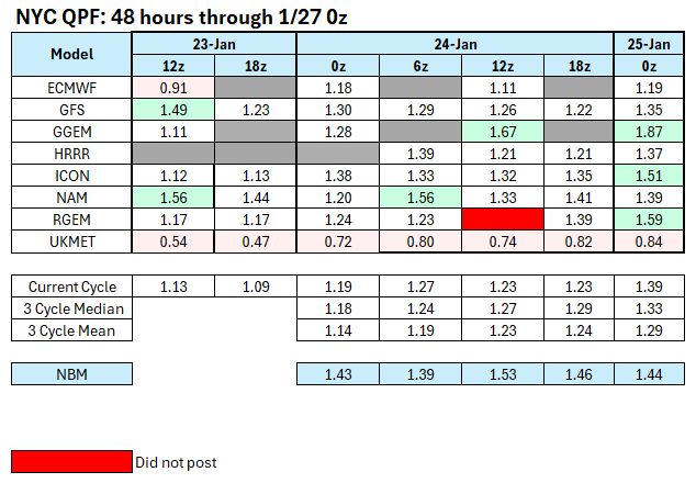
Central Park received 1.80" precipitation yesterday. The 0z GGEM was, by far, the closest model. The RGEM was a distant second.
-
January 2026 regional war/obs/disco thread
mahk_webstah replied to Baroclinic Zone's topic in New England
This one looks real. I’m on tracking overload. -

Winter 2025-26 Medium/Long Range Discussion
mimillman replied to michsnowfreak's topic in Lakes/Ohio Valley
I thought this set up typically favors N Central IN -

January 2026 regional war/obs/disco thread
Sey-Mour Snow replied to Baroclinic Zone's topic in New England
Just for fun and an idea of what that 6z run showed if it went out 24 more hours, it's widespread 2' plus of snow for at least SNE, with 50-70 mph winds.. On top of what we have now -
E PA/NJ/DE Winter 2025-26 Obs/Discussion
MJO812 replied to LVblizzard's topic in Philadelphia Region
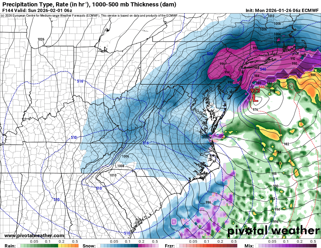
6z eps more west with coastal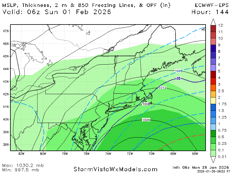
-

January 2026 Short/Medium Range Thread
fountainguy97 replied to John1122's topic in Tennessee Valley
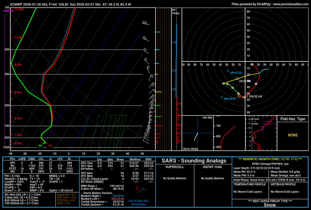
I will not get excited. I will not get excited. I will not get excited. I will no get excited. I will not get excited. I will not get excited. just absurd soundings for east tn.. ratios are 25:1+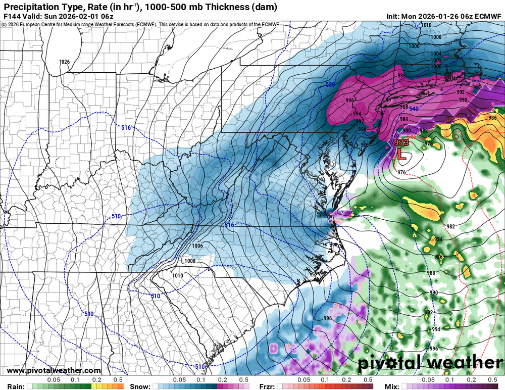
-
6z eps more west with coastal
-

The “I bring the mojo” Jan 30-Feb 1 potential winter storm
CentralNC replied to lilj4425's topic in Southeastern States
Mods, can we pin this? -
6z eps more west with coastal

-
I guess it contributed to the huge dry slot?
-

January 2026 Medium/Long Range Discussion
midatlanticweather replied to snowfan's topic in Mid Atlantic
Additionally other models, including the GFS, have been signaling just not consistently. Could have legs. I am so tire... But in it to win it -

E PA/NJ/DE Winter 2025-26 Obs/Discussion
Ralph Wiggum replied to LVblizzard's topic in Philadelphia Region
Eps for Feb 1:
-
12/5/25: 1.5” 12/14/25: 2.25” 1/17/26: T 1/18/26: .25” 1/24 - 1/25: 9” of snow and sleet Season Total: 13.0”
-
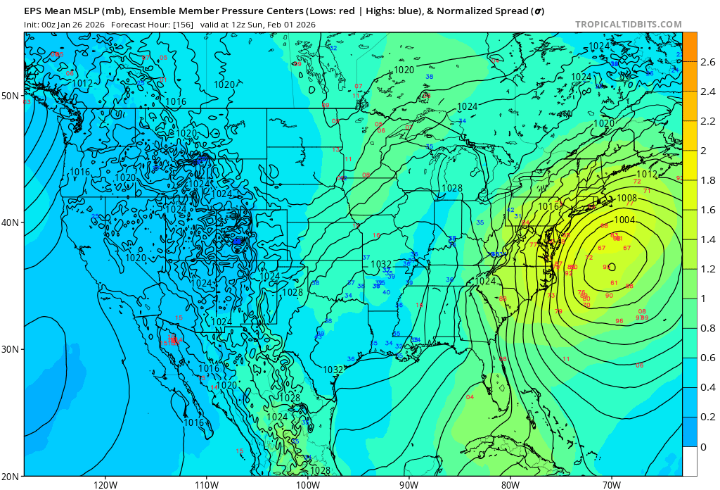
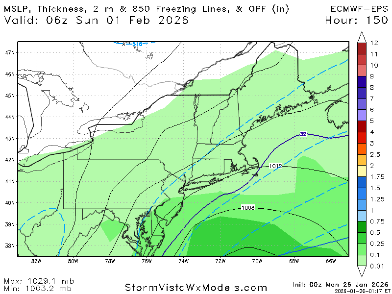
Those low heights at the core of this have to be a record for southern mid Atlantic, wild. 5-6 days out. A lot can go right or wrong, it’s a very tactile setup, not many events progress like the H5 of this. As posters on our discord mentioned, Blizzard of 66’, March 2001 are similar type events where the west side of a tpv dropped south and created a coastal. This is happening in primo winter time so… still, all options on the table at this range. .
-
I don't know. Maybe @donsutherland1 or @bluewave