All Activity
- Past hour
-
The punishment they will face will be tomorrow- when they get outcoached by the Bears lol. Monken again will refuse to stick with Henry the the run game-this time against a defense that is awful against the run, and will instead try to make Huntley into Dan Marino.
-

The return of the elusive Nor'easter. Drought buster or bust?
bncho replied to dailylurker's topic in Mid Atlantic
The return of the elusive Nor'easter. Drought buster or bust? BUST lol -

Pittsburgh PA Fall 2025 Thread
Ahoff replied to TheClimateChanger's topic in Upstate New York/Pennsylvania
Why would Allegheny County get another frost advisory? It went down to 33 earlier this month, isn't that frost levels? -
97 kts flight level, 970 mb extrap
-
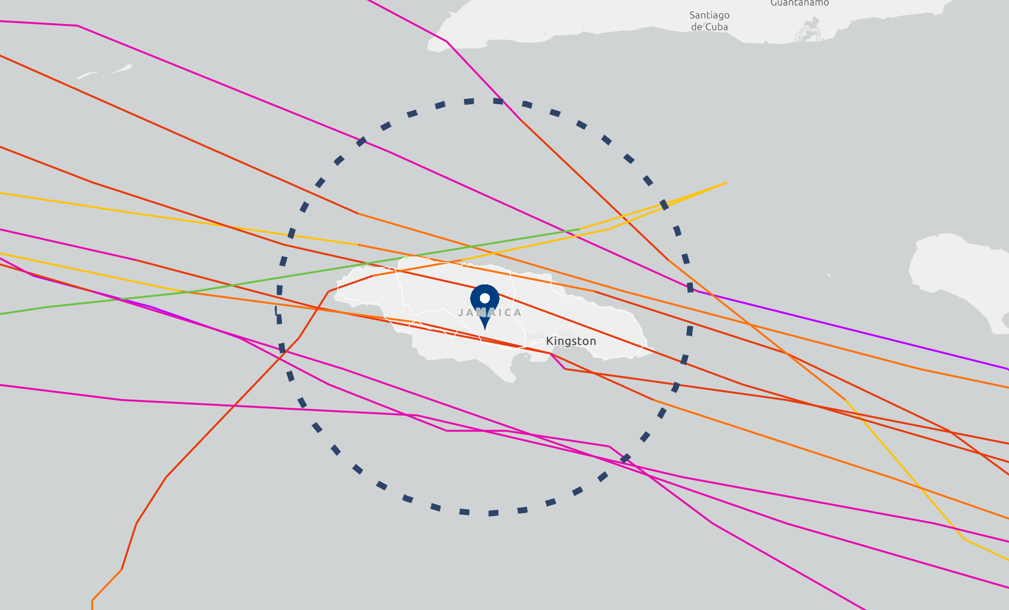
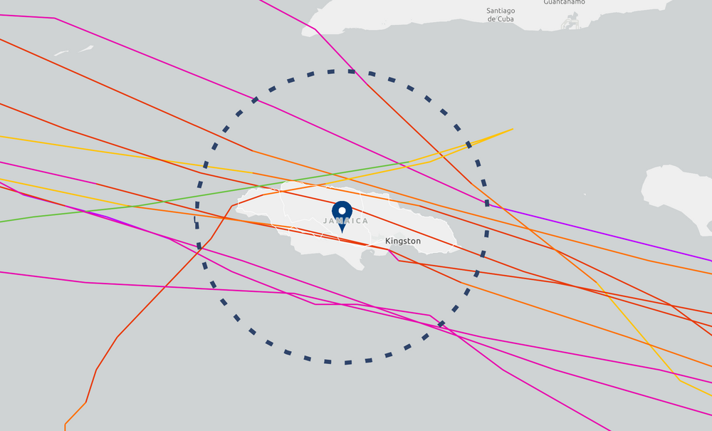
Lowest SLP on record Jamaica 958 Charlie followed by 960 Gilbert.
-
Jamaica's major hurricane history is not that extensive. Since 1900, only 4 major hurricanes have made a direct hit on the island: Unnamed 1903 (Cat 3 / 105kt) Unnamed 1912 (Cat 3 / 100kt) Charlie 1951 (Cat 3 / 110kt) Gilbert 1988 (Cat 4 / 115kt) Additionally, the 1903 hurricane, Charlie, and Gilbert all cut through the island from east to west relatively quickly. The 1912 hurricane hit the western tip. So, Melissa's forecast intensity (strong Cat 4 or Cat 5), slow forward speed, and angle of approach all combine to make this a highly unusual situation.
-
I'd be a little surprised if they face any punishment. This sounds nore like a dumb oversight than anything intentional.
-
Good. It will keep my candy bowl filled for myself now LOL
-
https://www.espn.com/nfl/story/_/id/46723952/nfl-looking-ravens-handling-jackson-practice-participation
-
True but not likely to happen. 18z already looks different
-
Doesn’t it pretty much always strengthen in November as we head into Winter?
- Today
-
 Count is now 13 5 3 and likely to reach 13 5 4 by Sunday or Monday. These potential scores and alternates for a 14th named storm later are now in the table above.
 -
All indications are that the SPV is going to strengthen in November right now
-

Spooky Season (October Disco Thread)
Modfan2 replied to Prismshine Productions's topic in New England
Start a Thread? -
Low 46, high 68. Another beautiful fall day here.
-

Spooky Season (October Disco Thread)
ineedsnow replied to Prismshine Productions's topic in New England
it wouldn't take much on that 18z ICON run to make things a bit more interesting with Melissa -
Spooky Season (October Disco Thread)
ineedsnow replied to Prismshine Productions's topic in New England
-
In 1993, IAD had a freeze on October 1. I was working a temp job in a building on Avion Parkway right next to the airport, and all the grass was white with frost.
-
This would be catastrophic for my parts if that happened. The winds would be pushing everything up the ny harbor into the rivers and high tide would be devastating with all that rainfall going nowhere. Would be IDA all over again if it happens.
-

Spooky Season (October Disco Thread)
dendrite replied to Prismshine Productions's topic in New England
1104hr looks good -
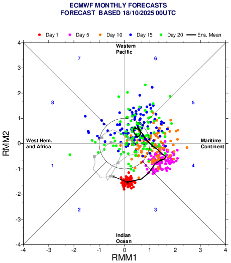
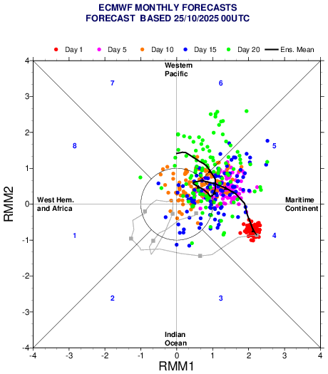
Generally not a fan of the RMM MJO charts. However, I think these euro weekly ones are beneficial. Mainly to visualize what the individual members are doing inside the mean and for trends. IMHO, not sure how anyone can call what happens with this event currently with any confidence. Still think it's too early. With that being said, lets look at the trend over the past week wrt this event. EC 46 one week ago versus today's forecast. A few things are noticeable. The verification vs the forecast from a week ago has been much higher in amplitude. With verification higher than the highest ensemble members forecast. The mean which was spiraling off into the COD is no longer doing so with a signal into the Pacific now. Also interestingly, later in the forecast period, there are many more members with renewed amplification in the Pacific now on today's run which just updated. This is still worth watching... One week ago: Today:
-

Central PA Fall Discussions and Obs
canderson replied to ChescoWx's topic in Upstate New York/Pennsylvania
Met a friend for lunch and when I got home the furnace was on. Oh well, happy wife and all -
There's been some epic fall mornings here in the lowlands the past several days. This weather has been amazing.

-
Hurricane Melissa Discussion Number 18 NWS National Hurricane Center Miami FL AL132025 500 PM EDT Sat Oct 25 2025 Melissa is likely beginning a period of rapid intensification (RI). Since both the NOAA-P3 and Air Force Reserve C-130 aircraft sampled the system this morning, the satellite presentation has continued to improve, with cold -75 to -80 C cloud tops wrapping around the center with hints of an eye starting to appear on visible images. The eye is also becoming better defined on radar images out of Jamaica with an overall diameter of around 20 n mi. In addition, an earlier GMI microwave pass received after the prior advisory showed a well-defined cyan ring on the 37-GHz, which is often a harbinger of RI. Subjective Dvorak intensity estimates were T5.0/90 kt from SAB, and T4.5/77 kt from TAFB. The objective estimates from UW-CIMSS were a little lower, but are also quickly rising, and the initial intensity will be set at 80 kt this advisory, blending these intensity estimates. The hurricane now appears to be moving slowly westward, at an estimated motion of 275/3 kt. A narrow mid-level ridge has built in to the north of Melissa, and should be the main steering feature over the next 24-48 hours to help move the hurricane slowly westward. The deep-layer steering vector still has a slight southward component, and it wouldn't be surprising to even see a little south of due west motion occur, like the Google DeepMind ensembles and ECMWF-AI model have been suggesting in the short-term forecast. After the next couple of days, the ridging to the north becomes quickly eroded by a shortwave trough moving across the southeastern United States. The net result of this changing synoptic pattern is that Melissa is expected to turn rather abruptly northward and northeastward by the early to middle part of next week. Compared to this morning, the track guidance has become more tightly clustered in the across track direction, and even the 12z GFS run, which was previous a eastward outlier, is now in better agreement with the track guidance suite showing a direct landfall in Jamaica. The main uncertainty is related to the amount of acceleration that Melissa will undergo after it turns to the northeast, and there remains large spread in the along-track direction in both the deterministic and ensemble guidance in the day 3-5 time frame. The NHC track forecast is only slightly more poleward compared to the prior forecast over the first 12-24 hours, and convergences very close to the prior track thereafter. This track is roughly a blend of the latest HCCA and GDMI track guidance. On this track, this brings Melissa's core near Jamaica early on Tuesday, and early on Wednesday along the eastern Cuba provinces, where a hurricane watch is now in effect. Rapid intensification appears to have started, and assuming Melissa stays far enough south of Jamaica over the next couple of days, there appear few impediments to its intensification in the short-term. Both the hurricane-regional models and the Google DeepMind ensembles suggest RI could continue for the next 36 to 48 hours. In fact, once again 4/5th s of the latter 50 member ensemble are forecasting a peak intensity of Category 5 intensity. The 12z HAFS-A run also showed a peak intensity of Category 5 in 48 hours, and both HAFS-A/B have been suggesting a similar peak on and off over the past few days. Given the current trends, the NHC intensity forecast now shows a 140 kt peak in 48 hours, in general agreement with this aggressive guidance. Afterwards, some inner-core oscillations such as eyewall replacement cycles could lead to fluctuations in intensity before its first landfall in Jamaica. It is worth stressing that there is very little practical difference in the overall impacts of a Category 4 or 5 landfall, and Melissa is expected to be at least that intensity when moves over Jamaica early next week. Land interaction will likely lead to some weakening as it moves northeastward across Jamaica, but the storm will likely also grow in size and is still forecast to be a major hurricane when it moves over Cuba by the middle of this week. Only after this period that southwesterly shear begins to increase in earnest after it moves into the Southwestern Atlantic. The NHC intensity forecast continues to be on the high end of the overall guidance, siding with the higher intensity aids such as GDMI (which has been the best preforming intensity guidance thus far this year) and HAFS-A, but all the hurricane-regional models show a peak intensity of at least Category 4 intensity. Needless to say, there is a very serious situation, in terms of catastrophic rainfall, wind, and storm surge hazards for Jamaica and preparations should be rushed to completion in the area currently under a Hurricane Warning. Key Messages: 1. Jamaica: A multi-day period of damaging winds and heavy rainfall is expected to begin tonight, causing catastrophic and life-threatening flash flooding and numerous landslides. Extensive infrastructural damage, long-duration power and communication outages, and potentially prolonged isolation of communities is likely. A life-threatening storm surge is also likely along portions of the southern coast early next week. All preparations should be completed today. 2. Haiti: Catastrophic and life-threatening flash flooding and landslides are expected across southwestern Haiti into early next week, likely causing extensive infrastructural damage and potentially prolonged isolation of communities. Strong winds could also potentially last for a day or more over the Tiburon peninsula. 3. Dominican Republic: Heavy rainfall could produce catastrophic flash flooding and numerous landslides in southern portions of the country. 4. Eastern Cuba, Southeast Bahamas, and the Turks and Caicos: Monitor Melissa closely. There is an increasing risk of a significant storm surge, damaging winds, and heavy rainfall by the middle of next week. In eastern Cuba, the risk of life-threatening flash flooding and landslides is increasing. A Hurricane Watch is now in effect for portions of eastern Cuba. FORECAST POSITIONS AND MAX WINDS INIT 25/2100Z 16.6N 75.5W 80 KT 90 MPH 12H 26/0600Z 16.7N 75.9W 100 KT 115 MPH 24H 26/1800Z 16.7N 76.5W 115 KT 130 MPH 36H 27/0600Z 16.7N 77.2W 135 KT 155 MPH 48H 27/1800Z 16.9N 77.6W 140 KT 160 MPH 60H 28/0600Z 17.6N 77.4W 130 KT 150 MPH 72H 28/1800Z 18.8N 76.7W 115 KT 130 MPH 96H 29/1800Z 22.0N 73.4W 90 KT 105 MPH 120H 30/1800Z 27.0N 69.0W 80 KT 90 MPH $$ Forecaster Papin
-
The repetitive pattern last month to 6 weeks has been southern systems with HP up north. Again this coming week............... I have commented on this more than once. Usually, patterns last less than 120 days, but usually is not always. If this continues into the winter................... Reasonable logic may need to be trashed...............