All Activity
- Past hour
-
You're gonna be surrounded shortly. The county is also pushing for one in the Urbana area.
-
The next named storm is Dolly. Dolly Parton’s passing was just announced.
-
You sure? Looks like plenty of mid to upper 90s for most piedmont and some 100's.
.thumb.png.33cf7788bb94492cd8d7af7c973a343e.png)
-

Augdewst 2026: Summer's Last Stand
WxWatcher007 replied to Prismshine Productions's topic in New England
+1=Torch? -
Worth it to mention... WV surplus/transport anomalies available in the general canvas. This would be due to both the increases that are CC attributed, whilst +ENSO and probable STJ input ... working on top of one another. Sounds like a QPF synergy monster if you ask me. Where it rains and/or snows it does with least excuse to do so and heavily. Relatively weaker profiled synoptic disturbances over-achieving.
-

Augdewst 2026: Summer's Last Stand
dendrite replied to Prismshine Productions's topic in New England
It whatever you want it to be -
2026 Atlantic Hurricane Season
WxWatcher007 replied to Stormchaserchuck1's topic in Tropical Headquarters
Similar to winter -
Definitely a cluster of ensembles trying to show a window in the western Atlantic, but you gotta survive to maybe take advantage of that.
-
 mexican online mail order pharmacy: MexiSafe Pharm - medicine online
 -
mexican online mail order pharmacy: MexiSafe Pharm - medicine online
-
This. As an old friend in the Mid-Atlantic forum used to say religiously…just give me the precip and I’ll take my chances.
-

Augdewst 2026: Summer's Last Stand
Brian5671 replied to Prismshine Productions's topic in New England
75 party cloudy here-perfect day out there. Sunset at 7:37 starting to really notice the early sunsets -
Yeah, mostly cloudy now with a few breaks, 75
-
It was the brightest one I have seen so far!
-

2026-2027 Record-breaking El Nino
GaWx replied to Stormchaserchuck1's topic in Weather Forecasting and Discussion
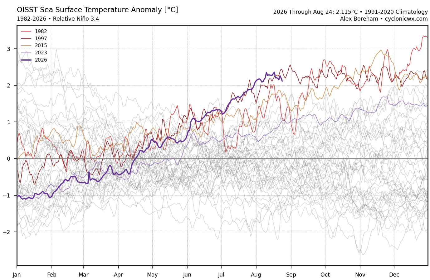
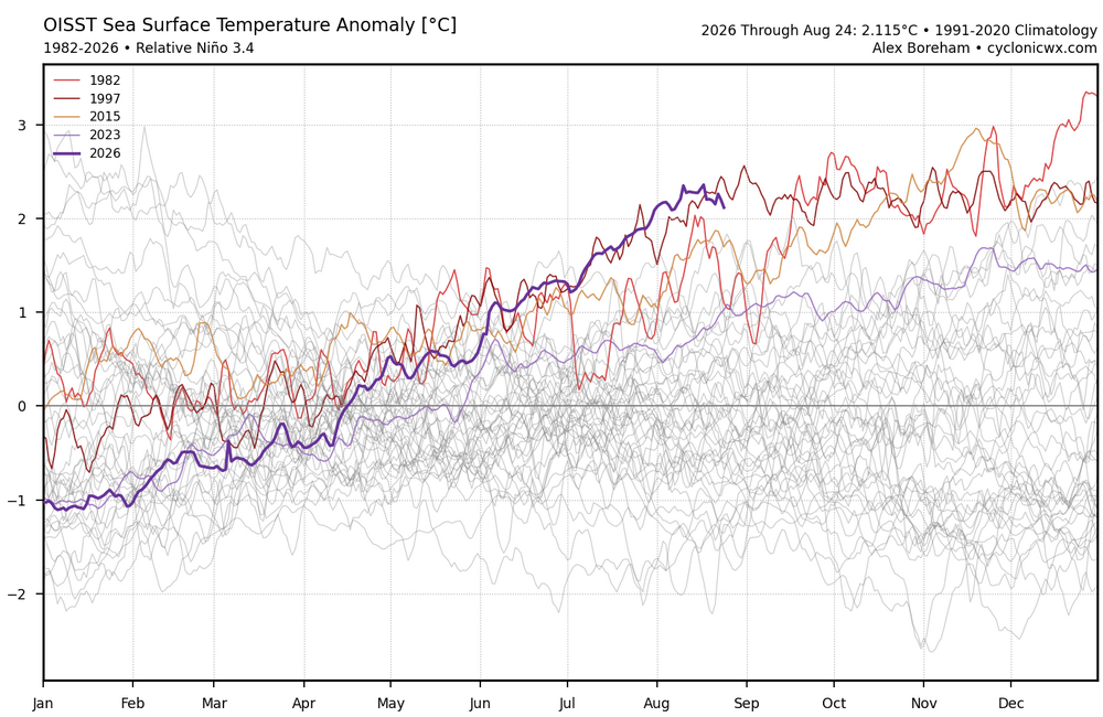
Thanks for posting that excellent graph! Now 2026 is essentially neck and neck with 1997. RONI/ONI will almost start warming again and likely soon/at a good pace, but: -it has clearly fallen behind model consensus that had steady warming throughout this month rather than the net flatness/pause of the last 3 weeks -so when warming resumes, even if in earnest, it will be restarting from a lower point than previously progged by models -

2026-2027 Record-breaking El Nino
mitchnick replied to Stormchaserchuck1's topic in Weather Forecasting and Discussion
-

2026 Atlantic Hurricane Season
cptcatz replied to Stormchaserchuck1's topic in Tropical Headquarters
Lol seriously. I don't need an hour by hour recap of what Andrew did 34 years ago on this day. -
Need an event that’s snow at 1100’+ WoR and 33 rain at Tolland.
-

Augdewst 2026: Summer's Last Stand
Brewbeer replied to Prismshine Productions's topic in New England
is a "furnace" hotter than a "torch" ? does the progression go like this: -0 to +0 average +1 to +2 warm +3 to +4 hot +5 to +6 torch +7 to +8 furnace or is it more like this: -0 to +0 average +1 to +2 torch +3 to +4 furnace +5 to +6 warm +7 to +8 hot I see from the reactions that others are also "confused" - Today
-
Hope so but I just think it’s going to generally be too mild even at elevation . Maybe NW CT van get one though i
-
12Z UKMET: similar to 0Z run with TCG by tomorrow along with rapid WNW movement in MDR along with it barely reaching TS status before weakening back to a TD though this time it remains a TC and strengthens back to a TS late moving much more slowly WNW near SE Bahamas:NEW TROPICAL CYCLONE FORECAST TO DEVELOP AFTER 30 HOURSFORECAST POSITION AT T+ 30 : 13.0N 32.0WLEAD CENTRAL MAXIMUM WINDVERIFYING TIME TIME POSITION PRESSURE (MB) SPEED (KNOTS)-------------- ---- -------- ------------- -------------0000UTC 27.08.2026 36 13.0N 34.0W 1008 291200UTC 27.08.2026 48 13.2N 38.0W 1007 330000UTC 28.08.2026 60 13.8N 41.9W 1008 331200UTC 28.08.2026 72 14.6N 46.5W 1009 360000UTC 29.08.2026 84 15.6N 50.9W 1009 331200UTC 29.08.2026 96 16.9N 55.1W 1010 350000UTC 30.08.2026 108 17.8N 58.9W 1010 331200UTC 30.08.2026 120 19.0N 62.6W 1009 350000UTC 31.08.2026 132 19.6N 65.4W 1008 301200UTC 31.08.2026 144 20.5N 68.0W 1008 310000UTC 01.09.2026 156 21.3N 69.7W 1007 351200UTC 01.09.2026 168 22.2N 71.7W 1006 38
-

Augdewst 2026: Summer's Last Stand
weatherwiz replied to Prismshine Productions's topic in New England
I'll never forget turning on TWC on 7/15/95 and like 6 AM and them talking about the line moving across the region. Fun times -
It wouldn’t be aeration and seed season here if it wasn’t dry.
-
I know a lot of this discussion is tongue and cheek, but given the high probability of above normal precip this winter, the potential for a couple of nasty / disruptive Nor'easters is on the table! Wall to wall snow cover! NO! But multiple big eastern US and East Coast storm events will produce some significant threats; including interior CT... Marginal temps for sure, but dynamic events nonetheless...
-
I was curious about this and went back to check. Fall 2015 was actually dry in the area. Not drastically, but modestly BN each month. So I looked at Fall 1997 and 1982 also. Sept 97 was pretty dry and it got wetter as fall progressed with a wet November. 82 was more of a mixed bag with some variation between the airports but you could say average-ish regionally. For more modest ninos, fall 2018 was a deluge. Fall 2014 slightly dry, fall 2009 mixed month by month, and fall 2002 was wet. So maybe the nino=wet fall correlation is mostly in our heads from more typical ninos. With the tiny sample size of strong/super ninos, a dry September at least would be in-family.


.png.4730f459e3414234449d11bbf2ee12b2.png)