All Activity
- Past hour
-

Central PA Winter 25/26 Discussion and Obs
Blizzard of 93 replied to MAG5035's topic in Upstate New York/Pennsylvania
The LSV has beef Advised for tomorrow! Winter Weather Advisory URGENT - WINTER WEATHER MESSAGE National Weather Service State College PA 805 PM EST Fri Jan 16 2026 PAZ057>059-065-066-171700- /O.EXB.KCTP.WW.Y.0004.260117T1000Z-260117T1700Z/ Dauphin-Schuylkill-Lebanon-York-Lancaster- Including the cities of Lebanon, Pottsville, Harrisburg, Lancaster, York, and Hershey 805 PM EST Fri Jan 16 2026 ...WINTER WEATHER ADVISORY IN EFFECT FROM 5 AM TO NOON EST SATURDAY... * WHAT...Periods of snow expected. Possibly mixed with some freezing rain and sleet. Total snow accumulations 1 to 3 inches. Ice accumulation around a trace. * WHERE...Dauphin, Lancaster, Lebanon, Schuylkill, and York Counties. * WHEN...From 5 AM to noon EST Saturday. * IMPACTS...Plan on slippery road conditions. -
.thumb.jpg.6a4895b2a43f87359e4e7d04a6fa0d14.jpg)
Central PA Winter 25/26 Discussion and Obs
Yardstickgozinya replied to MAG5035's topic in Upstate New York/Pennsylvania
Winter Weather Advisory URGENT - WINTER WEATHER MESSAGE National Weather Service State College PA 805 PM EST Fri Jan 16 2026 PAZ057>059-065-066-171700- /O.EXB.KCTP.WW.Y.0004.260117T1000Z-260117T1700Z/ Dauphin-Schuylkill-Lebanon-York-Lancaster- Including the cities of Lebanon, Pottsville, Harrisburg, Lancaster, York, and Hershey 805 PM EST Fri Jan 16 2026 ...WINTER WEATHER ADVISORY IN EFFECT FROM 5 AM TO NOON EST SATURDAY... * WHAT...Periods of snow expected. Possibly mixed with some freezing rain and sleet. Total snow accumulations 1 to 3 inches. Ice accumulation around a trace. * WHERE...Dauphin, Lancaster, Lebanon, Schuylkill, and York Counties. * WHEN...From 5 AM to noon EST Saturday. * IMPACTS...Plan on slippery road conditions. PRECAUTIONARY/PREPAREDNESS ACTIONS... Slow down and use caution while traveling. The latest road conditions for the state you are calling from can be obtained by calling 5 1 1. && $$ Hazardous Weather Outlook Hazardous Weather Outlook National Weather Service State College PA 817 PM EST Fri Jan 16 2026 PAZ057>059-065-066-180130- Dauphin-Schuylkill-Lebanon-York-Lancaster- 817 PM EST Fri Jan 16 2026 ...WINTER WEATHER ADVISORY IN EFFECT FROM 5 AM TO NOON EST SATURDAY... This Hazardous Weather Outlook is for central Pennsylvania. .DAY ONE...Tonight. Please listen to NOAA Weather Radio or go to weather.gov/StateCollege on the internet for more information about the following hazards. Winter Weather Advisory. .DAYS TWO THROUGH SEVEN...Saturday through Thursday. Please listen to NOAA Weather Radio or go to weather.gov/StateCollege on the internet for more information about the following hazards. Winter Weather Advisory. .SPOTTER INFORMATION STATEMENT... Spotters are encouraged to report significant hazardous weather. $$ Lambert -
Beautifully said. Thank you, sir. Now I must go back to watching Emily in Paris with my wife…while pre-gaming Oz with a few triple IPAs from RAR. Carry on! I’ll be back soon or passed out. Too early to call. 
-

E PA/NJ/DE Winter 2025-26 Obs/Discussion
Ralph Wiggum replied to LVblizzard's topic in Philadelphia Region
I cant be the only one that when I hear the term "AI" I immediately say "Allen Iverson" in my head -
Could the timing of this strong westerly wind burst in the pacific with the cold coming finally be our luck turning? Should beef up the subtropical jet quite a bit, and no surprise that the models are looking much more active in response.
-

Another Coating of Snow Saturday - "It's all we Got"
Sey-Mour Snow replied to Sey-Mour Snow's topic in New England
hRRR wagons NW lol .. Berks special -
So... when are ya coming back? Sunday or Monday?
-
The ones you don't trust especially that far out. AI is bias due to the programmer that provide input during its build. Wait till 2 days away. Unless you live on disappointments.
-
Yo @mitchnick 2026 ...WINTER WEATHER ADVISORY IN EFFECT FROM 5 AM TO NOON EST SATURDAY... * WHAT...Periods of snow expected. Possibly mixed with some freezing rain and sleet. Total snow accumulations 1 to 3 inches. Ice accumulation around a trace. * WHERE...Dauphin, Lancaster, Lebanon, Schuylkill, and York Counties.
-

January 2026 Short/Medium Range Thread
Weatheriscool replied to John1122's topic in Tennessee Valley
Just have rain here, it's about 40 -
@SnowenOutThere and I will ruin this thread if this isn't stopped in the next 48 hours. This is your last warning.
-
Those are rookie numbers. We need twenty members with 30" or more for goonfest 2026
-
Who’s ready for the 2-9” snowfalls tomorrow? [emoji23] .
-
temps going up though - it's above freezing here.
-

Another Coating of Snow Saturday - "It's all we Got"
Damage In Tolland replied to Sey-Mour Snow's topic in New England
No -
There are like 6-7 members that show 20"+ of snow @SnowenOutThere
-

First Legit Storm Potential of the Season Upon Us
HoarfrostHubb replied to 40/70 Benchmark's topic in New England
We should set up a pool…$10 on which cycle. -

Storm potential January 17th-18th
Brasiluvsnow replied to WeatherGeek2025's topic in New York City Metro
Its like spotting a BIGFOOT -
AIFS ensemble mean is lit up. Lord
-

First Legit Storm Potential of the Season Upon Us
Typhoon Tip replied to 40/70 Benchmark's topic in New England
To be honest, the AIGFS ticked southeast at 18 Z a little bit… I looked at the clock and I’m seeing 60 hours to go before game time. Yeah that’s 10 cycles plenty of time to cave. -
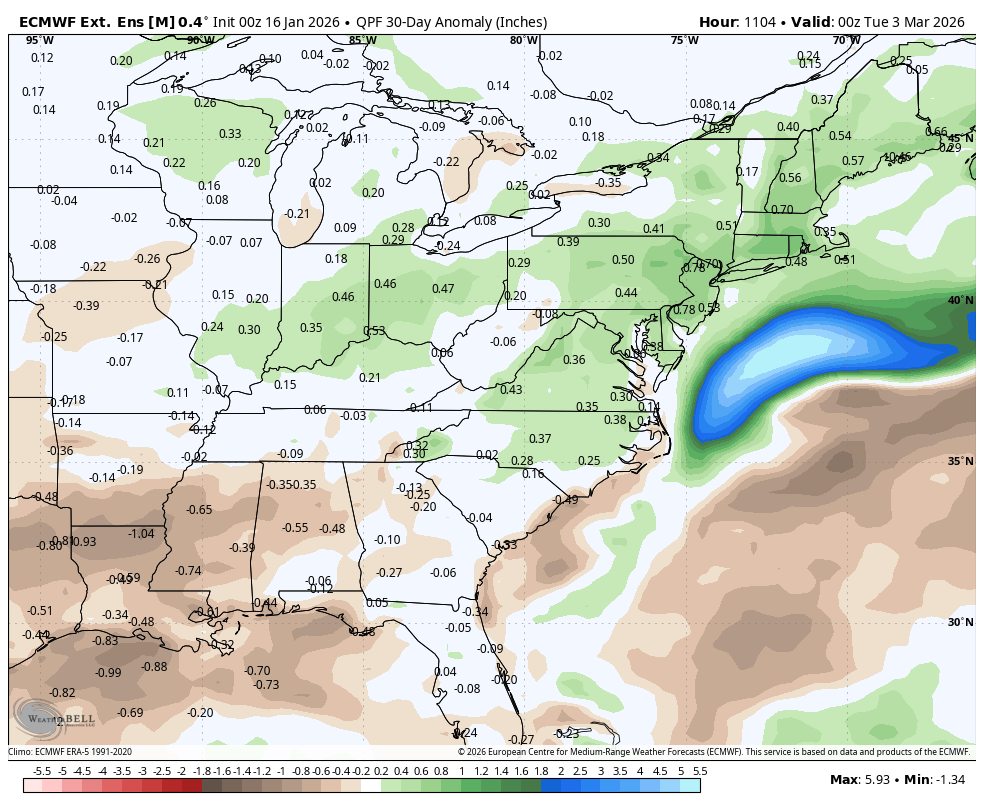
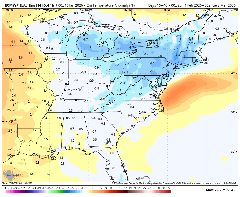
WB latest EPS extended thru early March is not a torch. Note this is the 30 day period ending March 2nd so it does not include the cold coming late January.


-
Welcome
-
-

Storm potential January 17th-18th
sussexcountyobs replied to WeatherGeek2025's topic in New York City Metro
Incoming 2-4" snow late tonight and tomorrow. Forecast low here is mid 2p's. Already down to 22.1° -
First Legit Storm Potential of the Season Upon Us
Damage In Tolland replied to 40/70 Benchmark's topic in New England
So hold up . I have the best chance of zero snow or snow on snow . Kev.. swallow the uzi or pull the trigger. Thanks for the vote of confidence