All Activity
- Past hour
-
.thumb.png.4150b06c63a21f61052e47a612bf1818.png)
July 2025 Obs/Disco ... possible historic month for heat
HIPPYVALLEY replied to Typhoon Tip's topic in New England
Perfect.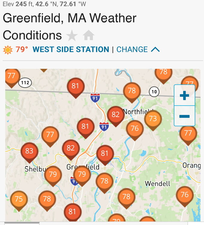
-
Very pleasant day for the dog days today. The air is cleaner, the sky clearer, and morning low in the 50s only rebounded to low-humidity 70s. Very depressing that it isnt going to last.
-

2025-2026 ENSO
michsnowfreak replied to 40/70 Benchmark's topic in Weather Forecasting and Discussion
Remember this is a coop station. The data is suspiciously cold. One thing that IS good about stations like this (coop stations, unmoved for 140+ years) is that you can still see the "good" and "not good" winters by comparing Ann Arbor to nearby Detroit. I have noted on multiple occasions that locally December has warmed the most, January not at all, and February slightly over the last 100 years. And Ann Arbor is yet another station that shows this. An increase of 3.4F in Dec, 0.0F in Jan, 1.5F in Feb. Avg January temperature regression the last 100 years (1926-2025) Toledo: -0.8F Detroit: -0.4F Flint: -0.1F Ann Arbor: 0.0F Saginaw: +0.3F -

July 2025 Discussion-OBS - seasonable summer variability
Wannabehippie replied to wdrag's topic in New York City Metro
Gorgeous cloud free day in Riverdale, NJ. -

July 2025 Obs/Disco ... possible historic month for heat
dryslot replied to Typhoon Tip's topic in New England
Sunny, 72/55°F with a nice breeze to keep the bugs away. -
Short term drought starting to bite. Only a couple hundredths yesterday after the 2” Wednesday
-

July 2025 Discussion-OBS - seasonable summer variability
gravitylover replied to wdrag's topic in New York City Metro
If you go I'll be easy to find, my wife has a booth in the vendor area. Look for the Looming Madness tent. -

July 2025 Obs/Disco ... possible historic month for heat
RUNNAWAYICEBERG replied to Typhoon Tip's topic in New England
Apparently construction guys on rooftops prefer 110 heat index…so they didn’t show up today. -

July 2025 Discussion-OBS - seasonable summer variability
winterwx21 replied to wdrag's topic in New York City Metro
82 with a dewpoint of 59 here right now. Feels good out there. I'm looking forward to early next week when dewpoints will go even lower. They might get down to the high 40s on Tuesday. Monday and Tuesday it will be top 10 day of the year type of weather. Take advantage of the great weather early next week before the heat comes back late week. The Euro is saying we could hit 100 next Friday. That might be a little overdone, but it'll be at least mid to upper 90s. -

July 2025 Discussion-OBS - seasonable summer variability
Dan76 replied to wdrag's topic in New York City Metro
They do a great Godzilla!! -

July 2025 Obs/Disco ... possible historic month for heat
dendrite replied to Typhoon Tip's topic in New England
Very difficult day to find joy in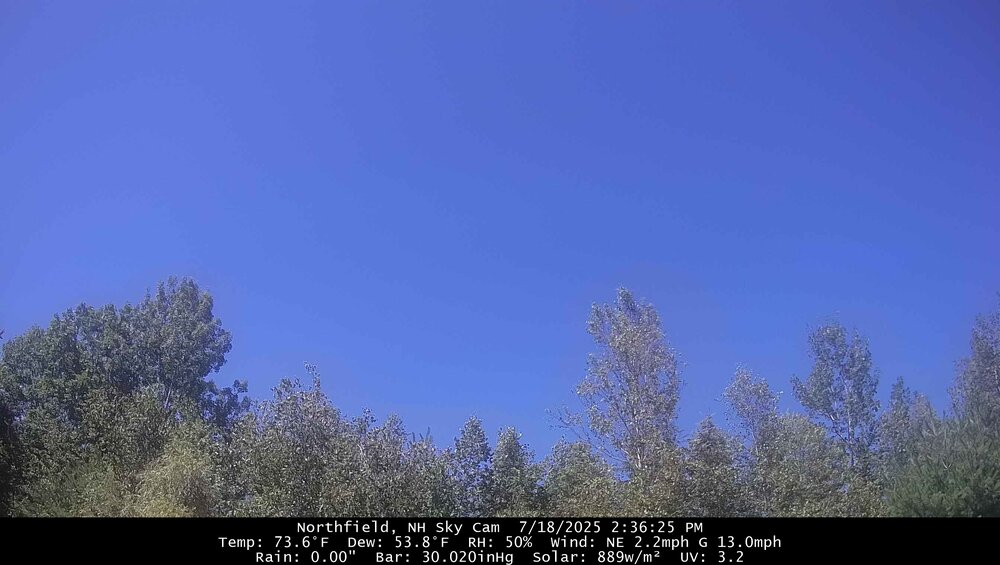
-
I think there's nothing they can do at Central Park if the Conservatory refuses to trim the trees. Thus, since monthly and annual data can be adjusted as appropriate to compensate for the site changes that have affected high temperatures during the foliage season, the station goes on as is. I suspect that the value of a long-term climate record supersedes the loss of quality of day-to-day readings.
-

July 2025 Obs/Disco ... possible historic month for heat
powderfreak replied to Typhoon Tip's topic in New England
It’s sunny. Rains were last night and early AM. -

Mountain West Discussion
mayjawintastawm replied to mayjawintastawm's topic in Central/Western States
May 20-June 25 were remarkably wet, so on average we are unremarkable in the SE half of the Metro- it's more that "dry begets dry" all over again once it gets started. -

July 2025 Obs/Disco ... possible historic month for heat
Damage In Tolland replied to Typhoon Tip's topic in New England
If it’s active in upslope rains. That’s a problem - Today
-
The WPC has dropped from 3.00 inches of rain for Augusta to .25"!!!!!!!!!! AS Jackie said 60 years ago.................. "How Sweet It Is"
-
Seems like more cloudy days than usual this summer with rain trying to move in from the west.
-
July 2025 Obs/Disco ... possible historic month for heat
dendrite replied to Typhoon Tip's topic in New England
Straight outta Campton? -

July 2025 Obs/Disco ... possible historic month for heat
CoastalWx replied to Typhoon Tip's topic in New England
About to become more dangerous with the Notorious NOG. -
This is my favorite so far.

-
We have only had one October really amplified MJO 5-6 during each multiyear La Niña going back to 2010. October 2024…+2.76…October 2020…+2.81….October 2017…+3.35….October 2010….+2.88. The other La Niña years surrounding these in each group had a weaker October MJO in 5-6 like in 2022, 2021, 2016, and 2011. So the more amplified October years featured La Niña +PNA mismatches. With the exception of last year, these were very snowy winters. But the WPAC pattern and Pacific Jet never relaxed last winter like all the previous mismatch winters did. This is what I was pointing out last year why I mentioned early on that there were competing influences which didn’t exist during the other winters. So not to expect the same type of outcome. So this would be a first time occurrence if the MJO 5 peaked again this October in the +2.76 to +3.35 range. Seems like it’s some type of fall forcing event which affects the winter PNA during La Ninas. It’s why my guess a few months back that this 25-26 winter will be warmer than last winter was with the PNA averaging less positive than last winter did. But since the snowfall was so low last winter, it wouldn’t take much for one decent snow event to surpass last seasons snowfall totals from around Philly to Boston. Plus it’s possible that we could get a least one winter month with a decent +PNA like we saw in January 2022 even though the PNA was strongly negative in December tilting the whole winter -PNA. That was largely driven by the MJO 8. January 2022 was the last winter month around NYC which was both cold and snowy especially Long Island. We have also seen very impressive 500 ridges in Canada since the 2023-2024 El Niño generally boosting the +PNA. So we’ll have to wait for the October verification this year to know if it will be like past multiyear La Ninas following the mismatch winters like we had in 2024-2025. Always have to leave open the possibility of a first time occurrence with back to back mismatch events. But this hasn’t happened yet since 2010.
-
Don is it possible that the NWS still sees all this park data as circumstantial evidence? How sad …. As always ….
-

July 2025 Discussion-OBS - seasonable summer variability
lee59 replied to wdrag's topic in New York City Metro
So much more comfortable today, 80 degrees here. Last night was one of the warmest nights I have seen in my area. It was actually great pool weather and the breeze was warm and made the temperature bearable. -
July 2025 Obs/Disco ... possible historic month for heat
dendrite replied to Typhoon Tip's topic in New England
Idk…it’s been dangerous in NNE lately. -
July 2025 Obs/Disco ... possible historic month for heat
dryslot replied to Typhoon Tip's topic in New England
I will be tonight, Enjoying a beverage and a Cigar by the fire pit.