All Activity
- Past hour
-
1/4in of snow here and falling steadily. I wasn't expecting that!
-
right now the GFS is alone with anything significant that ain't a cut or whiff, but all have something in that time frame that can pop, we'll see and maybe a convergence comes about for something good, at least we track...
-
@ravensrule you call my posts "shit" but you will eat your words when you spend 10 days with a bunch of nonsense analysis tracking a cutter rainstorm. Whereas my simple climo analysis will verify. We will revist this next week
-

Central PA Winter 25/26 Discussion and Obs
Blizzard of 93 replied to MAG5035's topic in Upstate New York/Pennsylvania
6z GFS for next weekend has a snow to to mix/rain back to snow long duration scenario for CTP. Long way to go & many developments still to come in the upcoming days as we continue to track the potential.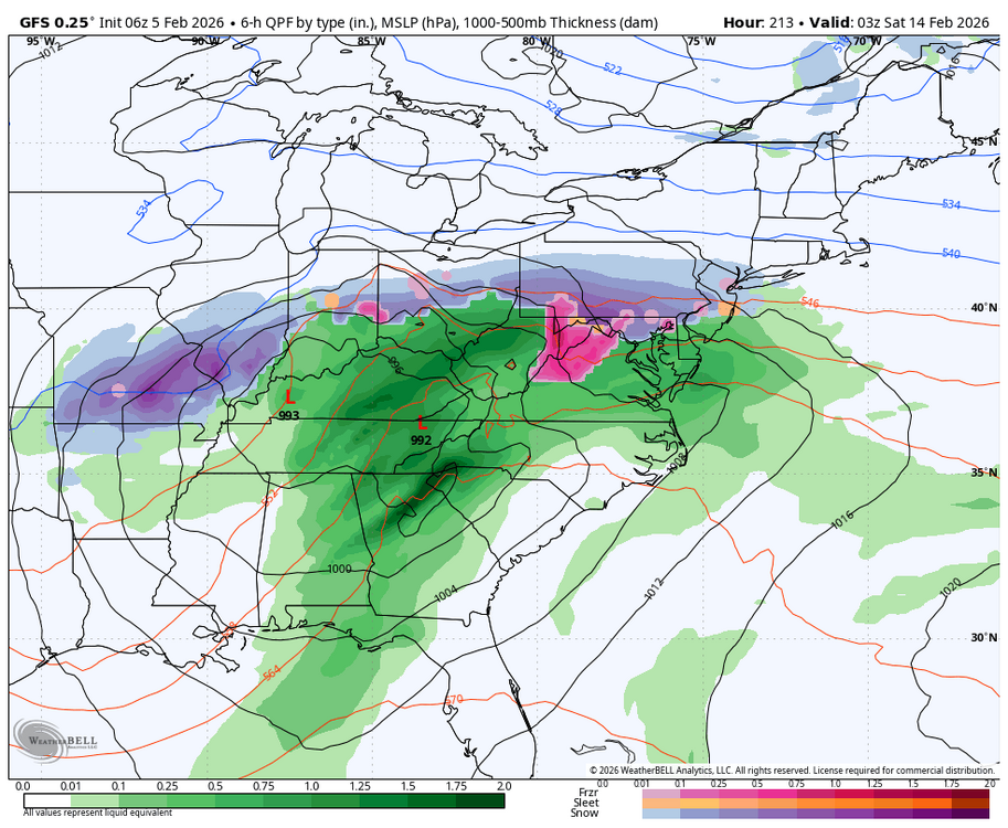
-
Hopefully not. We'd be dealing with a lot of pot holes and even ice jams Not sure how bad the overall icing situation is though compared to 2015
-
Central PA Winter 25/26 Discussion and Obs
Blizzard of 93 replied to MAG5035's topic in Upstate New York/Pennsylvania
Low of 7 in Marysville. -

February 2026 Medium/ Long Range Discussion: Buckle Up!
anotherman replied to Weather Will's topic in Mid Atlantic
Yes, it sucks to not wake up to pretty snow maps, but it doesn't mean winter is over. -

Is we back? February discussion thread
Damage In Tolland replied to mahk_webstah's topic in New England
That Euro run last night makes no sense screaming a low like that the block . You’d have to think secondary at least with icing and probably even colder than that. That run is tossed -

Mid-Long Range Discussion 2026
WinstonSalemArlington replied to BooneWX's topic in Southeastern States
February 16 -

February 2026 Medium/ Long Range Discussion: Buckle Up!
ravensrule replied to Weather Will's topic in Mid Atlantic
He probably puts the same amount of shit in his toilet every morning. -
Imagine losing Stoutland and Fangio in the same offseason. Thank goodness Fangio decided to stay another year. Sounds like last year's dysfunction got to Stoutland, though, which is extremely disappointing. What a waste.
-
This has been some stretch of cold and snow pack. It will feel nice when those first mild temperatures arrive.
-
I had a quarter inch of snow myself. Roads are horrible in Haywood until you hit the interstate. Smokey park and Patton Avenue are very slick and roads in Arden are bad.
-
Not really much BN. They’ve just been torched.
-
Boston harbor 39. But that’s out there and I think 5’ down or so. Definitely less of an issue vs December.
-
Is we back? February discussion thread
Damage In Tolland replied to mahk_webstah's topic in New England
Anyone get the feeling with the WBN SST’s that it’s gonna be an awful long cold spring? -
Mid-Long Range Discussion 2026
WinstonSalemArlington replied to BooneWX's topic in Southeastern States
After an early week thaw, cold punches back back late next week in the East ? -

Is we back? February discussion thread
40/70 Benchmark replied to mahk_webstah's topic in New England
Looks like SSTs are around 35-36 BEFORE this weekend....man, please get a juicy hugger in here to lather me up with deep layer east fetch. -

February 2026 Medium/ Long Range Discussion: Buckle Up!
Chris78 replied to Weather Will's topic in Mid Atlantic
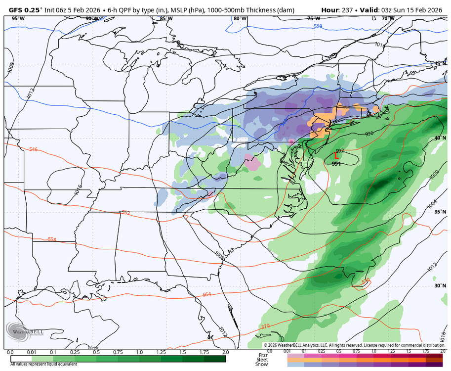
I don't have the snow mean but this doesn't look like a cutter to me..thumb.png.93fd706cc9545b939aaef26544065185.png)
-

Central PA Winter 25/26 Discussion and Obs
Summit Snow replied to MAG5035's topic in Upstate New York/Pennsylvania
sued: 12:49 AM Feb. 5, 2026 – National Weather Service ...EXTREME COLD WATCH IN EFFECT FROM LATE FRIDAY NIGHT THROUGH SUNDAY AFTERNOON... * WHAT...Dangerous wind chills colder than 20 below zero possible. * WHERE...All of central New York and northeast Pennsylvania. * WHEN...From late Friday night through Sunday afternoon. * IMPACTS...The dangerously cold wind chills as low as 30 below zero could cause frostbite on exposed skin in as little as 30 minutes. Frostbite and hypothermia will occur if unprotected skin is exposed to these temperatures. * ADDITIONAL DETAILS...An arctic front will bring cold air and strong winds to the region Saturday morning. Below normal temperatures and blustery winds will result in wind chills dropping well below zero Saturday morning. Wind chills will remain below zero through the rest of the weekend. -
Looks like we head into warmer and rainy next weekend per euro and gfs though still cold
-
Low of -2F 15th morning below zero this winter!
-
Just a flurry here. Not complaining.. Hope somebody gets something worthwhile out of this!
-
2025-2026 ENSO
40/70 Benchmark replied to 40/70 Benchmark's topic in Weather Forecasting and Discussion
Nice. I had -1 to -1.2 as the forecast peak RONI range. -

February 2026 Medium/ Long Range Discussion: Buckle Up!
CAPE replied to Weather Will's topic in Mid Atlantic
Your 'analysis' is a broad generalization and is whiny and lazy as fuck.


.png.593301791479844b8191f7792e5f3bd0.png)

.thumb.png.4150b06c63a21f61052e47a612bf1818.png)