All Activity
- Past hour
-
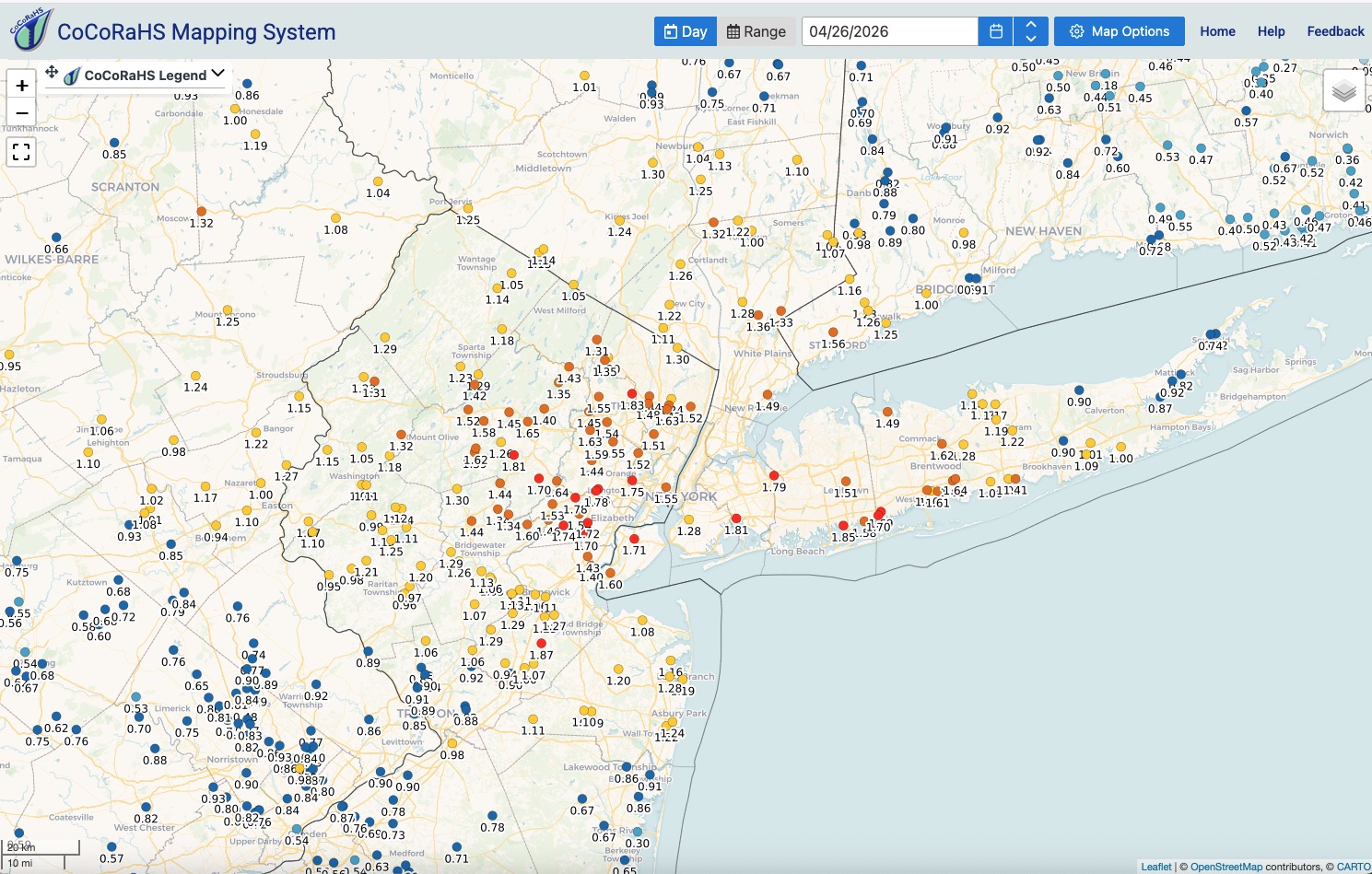
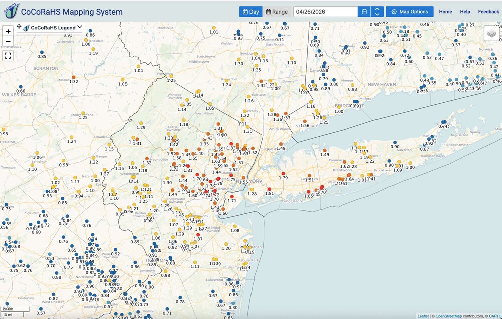
Just under 1.5" 9f much needed rains. New rain guage makes it easy to read.
-
Be sure to check back in with us in late May after we have our below average May.
-
One of those days where you can just sniff how close the days of HHH are. It’s coming

-
60F and rising fast… sunny Sunday. Warm stick season.
-
Just planted a few natives and boy is the soil dry despite rain the last 2 days.
-
-
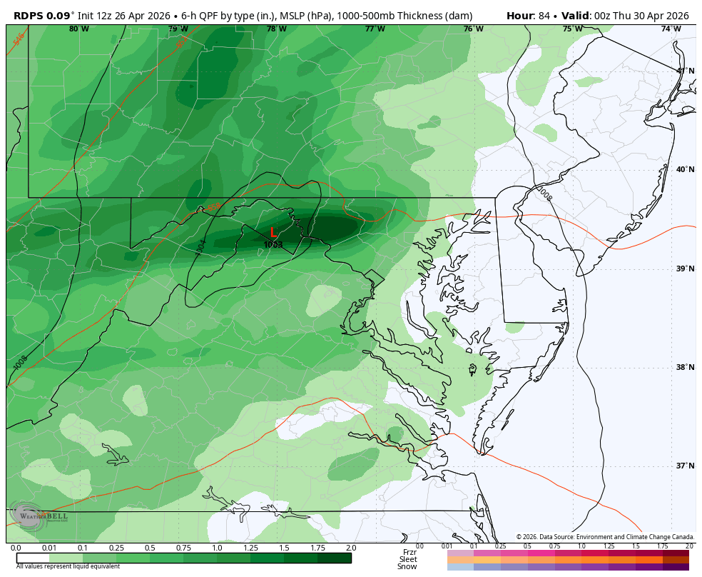
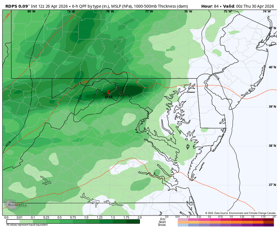
WB 12Z RDPS for Wed. And not done yet....
-
Stuck at 47. Can't wait for these clouds to burn off/move out. Hopefully by 2pm we'll be off to the races. Will be on vacation all week so great that Monday and Tuesday are going to perfect weather.
-
Deep blues, washing truck and tanning today .
-
4 out of the Top 8 happened in developing strong el nino years.
-
(002).thumb.png.6e3d9d46bca5fe41aab7a74871dd8af8.png)
E PA/NJ/DE Spring 2026 Obs/Discussion
ChescoWx replied to PhiEaglesfan712's topic in Philadelphia Region
Hi Mike - no doubt a silly question for you!! But in the AFD write up what determines unseasonably warm or unseasonably chilly? Is there a degree threshold above or below or subjective? Yesterday was in my view unseasonably chilly with temps around 10 degrees below normal values - yet in the AFD it said seasonably chilly. Thanks! Paul -
Central PA Spring 2026 Discussion/Obs Thread
ChescoWx replied to Voyager's topic in Upstate New York/Pennsylvania
We received between 0.50” to 1.04” across the County with more falling across the north with that higher amount recorded at the Chester Springs DEOS station. We continue with unseasonably chilly weather today with highs remaining around the middle 50’s. Tonight, we could see some patchy frost and even a freeze in some of our typically colder valley locations We moderate to near normal in the mid 60’s both Monday and Tuesday before we turn chillier again and wetter by mid-week.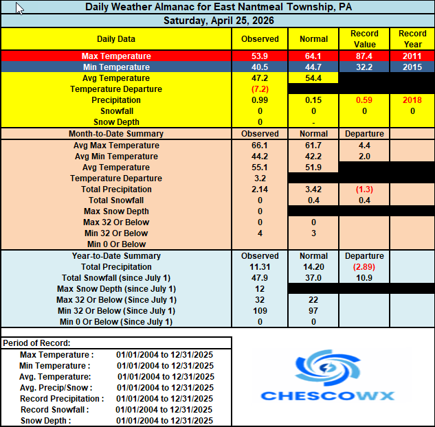
-
E PA/NJ/DE Spring 2026 Obs/Discussion
ChescoWx replied to PhiEaglesfan712's topic in Philadelphia Region
We received between 0.50” to 1.04” across the County with more falling across the north with that higher amount recorded at the Chester Springs DEOS station. We continue with unseasonably chilly weather today with highs remaining around the middle 50’s. Tonight, we could see some patchy frost and even a freeze in some of our typically colder valley locations We moderate to near normal in the mid 60’s both Monday and Tuesday before we turn chillier again and wetter by mid-week.
-
T-Wolves with a costly win last night. Divincenzo out for the season, Antman out for extended time, and then pissing the Nuggets off at the end of the game with an uncontested layup. Nuggets in 7 wouldn't surprise me, though they probably need Gordon back (calf injuries are thorny).
-

Potential Sever Weather Outbreak 4/27/2026
andyhb replied to pen_artist's topic in Lakes/Ohio Valley
Probably worth pointing out that the 12z HRRR has a) a lot of morning convection and b) what is likely a significant tornado outbreak later across E MO and W IL. The outflow restricts some of the spatial extent of the threat, but recovery occurs quickly given the strength of the wind fields. -
Just over an inch in Cary in the past 24 hours. .
- Today
-
Thought we received a little more than that, but then again it was mostly short duration showers.
-
It's weird because I don't remember the weather being like this where we basically get 3 nice days per week. Maybe I just notice it more as I get older because my hobbies have changed and I simply crave (or need via Vitamin D) more sunshine. I still like storms, but I much prefer when it's a t-storm surrounded by generally nice weather as opposed to this nickel and dime stuff.
-
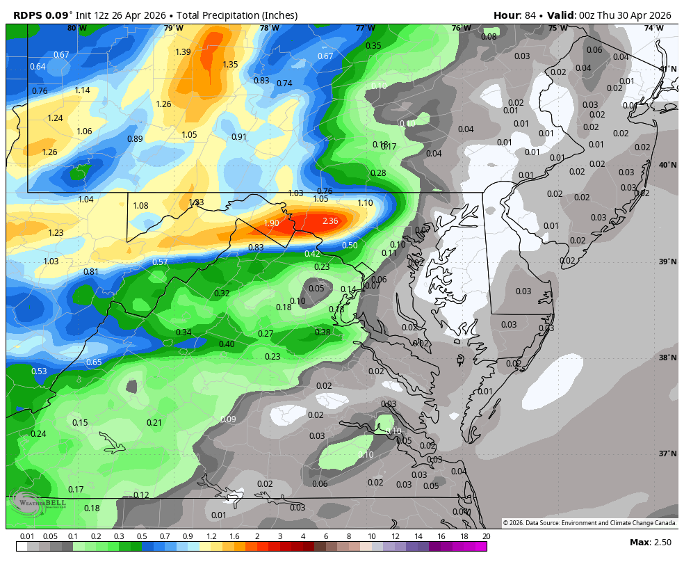
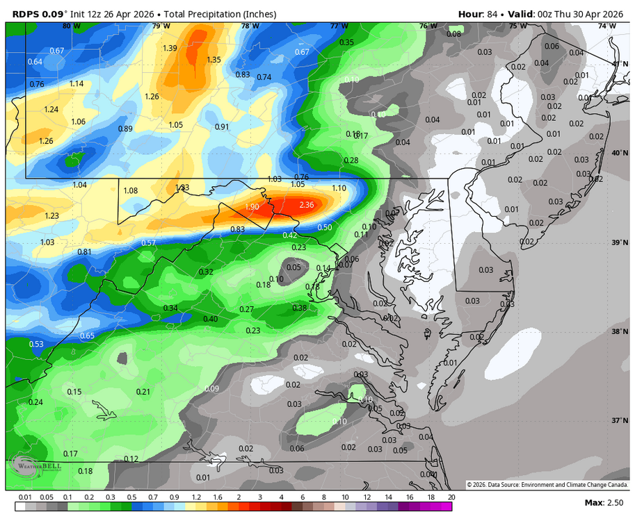
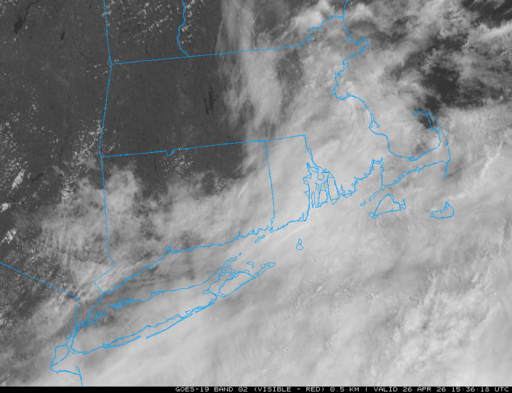
1.52" here for the event. A nice slow and steady soaking for this sub forum. Click map to enlarge.
- 907 replies
-
- 1
-

-
- april showers bring may..
- rain
- (and 2 more)
-
Looks like Wednesday night into Thursday another decent rain event
- 907 replies
-
- 1
-
-
- april showers bring may..
- rain
- (and 2 more)
-
We might be heading towards one of our coolest May's since 1967.
-
April 26 1954: Extremely heavy downpours occur in Mora, where nearly 7 inches of rain would fall in a little over 10 hours. For Sunday, April 26, 2026 1834 - Killer frosts were reported in the Deep South. The frost was quite severe around Huntsville AL, and highlighted a backward spring in the South that year. (David Ludlum) 1978 - An unusually strong occluded front swept out of the Gulf of Alaska and produced the first April thunderstorm of record at Fairbanks. Pea size hail fell northeast of Fairbanks from thunderstorms whose tops were less than 8000 feet. (The Weather Channel) 1984 - Severe thunderstorms associated with an intense cyclone spawned a total of forty-seven tornadoes in two days from Louisiana to Upper Michigan. The tornadoes killed 16 persons and injured 259 others. (Storm Data) 1987 - Twenty-two cities in the central and western U.S. reported new record high temperatures for the date. The afternoon high of 83 degrees at Astoria OR smashed their previous record by 13 degrees. Sacramento CA hit 94 degrees. (The National Weather Summary) 1988 - While Rochester, MN, was blanketed with 13.7 inches of snow, establishing a single storm record for the month of April, Minneapolis MN, just 90 miles away, got only rain. (Storm Data) (The National Weather Summary) 1989 - Thirty-three cities in the central and southeastern U.S. reported record high temperatures for the date. Afternoon highs of 91 degrees at Evansville IN and Nashville TN equaled April records. Thunderstorms produced severe weather from Iowa to Kentucky, with more than ninety reports of large hail and damaging winds. Thunderstorm winds gusted to 90 mph at Berwick IA. (The National Weather Summary) (Storm Data) 1990 - Twenty-nine cities from the Carolinas to the Great Lakes Region and western New England reported record high temperatures for the date as readings soared into the 80s and lower 90s. Record high temperatures included 95 degrees at Baltimore MD and 92 degrees at Allentown PA. The record high of 89 degrees at Alpena MI was the third out of six straight record highs for that location, and smashed their previous record for the date by ten degrees. (The National Weather Summary) 1991 - Severe thunderstorms in the central U.S. spawned fifty-five tornadoes from northeastern Texas to Iowa and eastern Nebraska killing twenty-one persons. Early evening thunderstorms over south central Kansas spawned a violent (F-5) tornado which traveled 45 miles from southwest of Wichita to north of El Dorado. It killed seventeen persons, including thirteen at the Golden Spur Mobile Home Park in Andover. The tornado also caused 62 million dollars damage to McConnell Air Force Base as it crossed the south side of Wichita. (National Weather Summary 2003 - Twenty inches of snow falls in California's Sierra Nevada Mountains. Alpine Meadows ski resort just north of Lake Tahoe reports more than 100 inches and Kirkwood south of Tahoe reports 112 inches.
-

Potential Sever Weather Outbreak 4/27/2026
Chicago916 replied to pen_artist's topic in Lakes/Ohio Valley
Tomorrow's a wake up and see day. No point to modeling. -
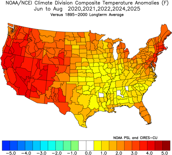
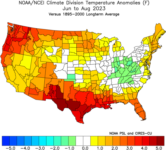
2009 would probably be too big of an ask in this much warmer climate. It was the 2nd coolest June and July on record at spots like Islip. 2023 was our last summer with a developing El Niño that became very strong. Was cooler overall than the other 2020s summers so far but still not really cool by historical standards. Time Series Summary for Islip Area, NY (ThreadEx) 10 Coolest June 1 to July 31 Periods Click column heading to sort ascending, click again to sort descending. 1 1965-07-31 67.9 0 2 2009-07-31 68.2 0 3 1978-07-31 68.5 0 4 1979-07-31 68.7 0 - 1968-07-31 68.7 0 5 1992-07-31 68.9 0 6 1982-07-31 69.0 0 7 1964-07-31 69.2 0 8 1972-07-31 69.3 0 9 1985-07-31 69.4 0 10 2000-07-31 69.6 0 - 1996-07-31 69.6 0
-

2026-2027 El Nino
George001 replied to Stormchaserchuck1's topic in Weather Forecasting and Discussion
Agree. The facts are fairly straightforward. An El Niño is developing, and it is developing similarly to previous strong and super ninos. If it does become a super Nino it won’t be the first one, and certainly won’t be the last. Personally I don’t think it’s a huge deal, I mean im not too happy about it because it’s an unfavorable ENSO state for cold and snow for my area, but it’s not like the El Niño itself is an actual threat to our lives or anything. 2015-2016 happened, life went on. Same thing will happen with this event.