All Activity
- Past hour
-
No problem. Also, I support you making a thread to share those posts. Plus it would be fun to see how models changed over the course of tracking. Many would support you.
-
When the GFS prints out 35” of snow and then the euro shows next to nothing for same spot in NC 3 days out it tends to do that to people
-

1/23/26-1/25/26 Winter Storm Thread
Holston_River_Rambler replied to AMZ8990's topic in Tennessee Valley
18z EPS make of it what ye will: run. to run snow change: -
If they are sampling tomorrow, it probably wouldn't get injested until 18z? Even if they sample at 8am pst, GFS is already rolling by then.
-
Look, at some people we really are going to have to tighten up the storm thread. I'm calling myself out too, but I'm not exactly posting strictly to the rules (and the mods know they can (and have) mod me because I can be just as bad as anybody else. I know excitement gets to us, so I've been a lil more liberal with moderating. Mainly because I'm a trash moderator. So at some point (prob tomm) we are gonna have to buckle down.
-
At this point I’m ready for the hi res models (I’m getting ahead of myself)… it’s exhausting riding the roller coaster over and over. .
-

Southern MD / Lower Eastern Shore weather discussion
csnavywx replied to PrinceFrederickWx's topic in Mid Atlantic
More like orange at this point. All systems go for red tomorrow if this holds. -
think it's this one: https://www.weather.gov/lwx/experimentalwinterstormthreat
-
With it being a cold very dry snow. Even though we won't reach blizzard criteria. It could be quite breezy ..I'm sure we will see some blowing and drifting
-

January 2026 regional war/obs/disco thread
ineedsnow replied to Baroclinic Zone's topic in New England
18z CMC looking better for tomorrow night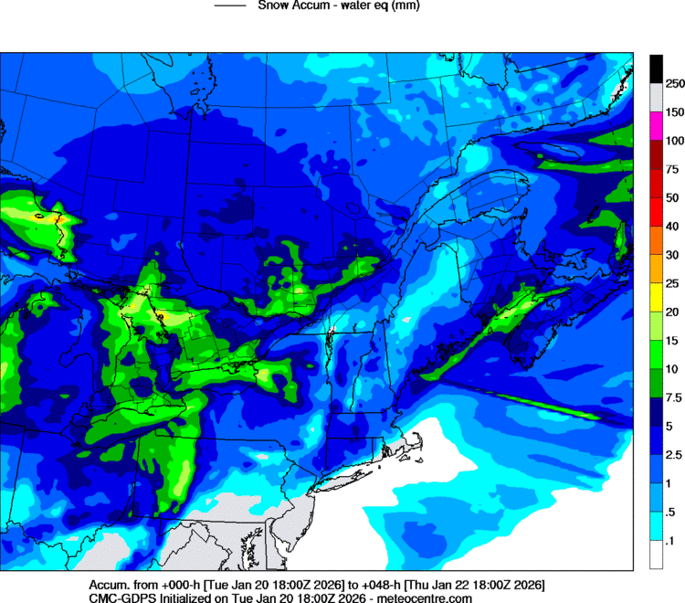
-

January 2026 regional war/obs/disco thread
CCHurricane replied to Baroclinic Zone's topic in New England
Storm thread is not allowed to be opened until inside of D3 -
Agreed wholeheartedly.
-
https://www.weather.gov/lwx/wintermaps
-
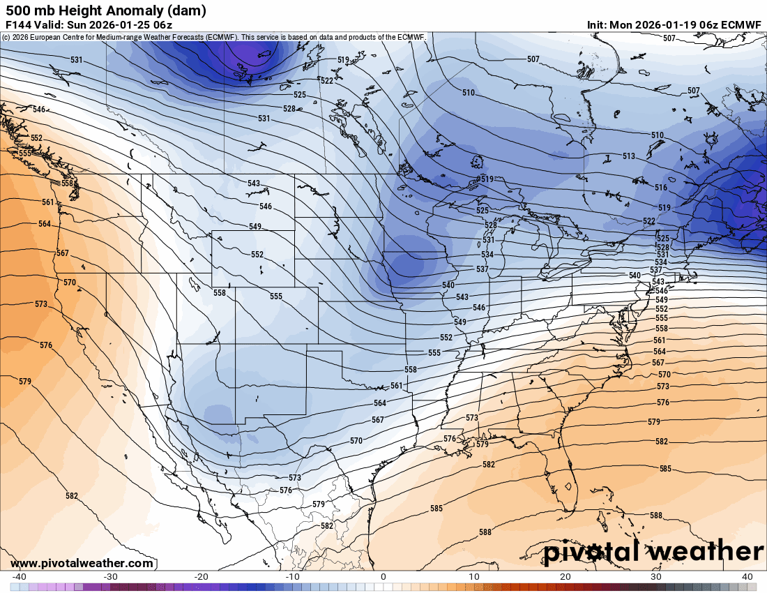
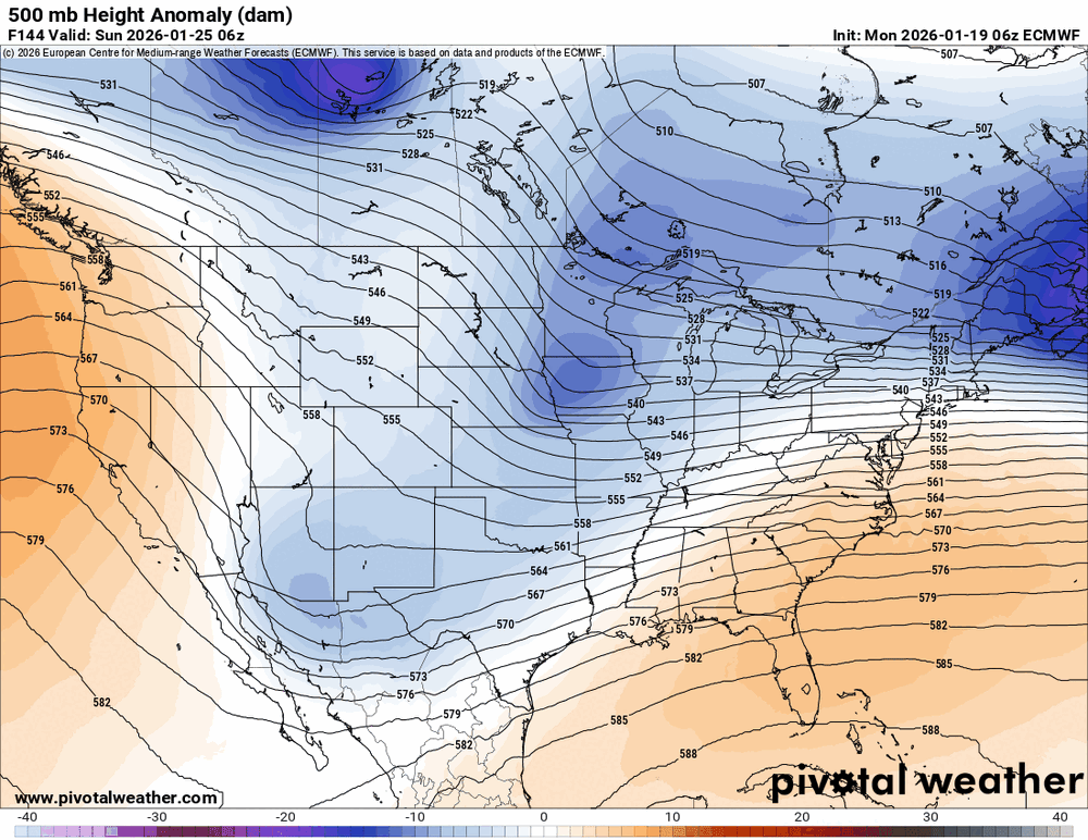
That northern stream wave/lobe of the PV continues to get stronger with each passing Euro run. Not sure if that continues, but it absolutely raises the ceiling on this if it phases. I should probably add that it also may induce more mixing concerns for areas further south, as it would lead to SE ridge amplification and WAA aloft.
-

January 2026 regional war/obs/disco thread
Typhoon Tip replied to Baroclinic Zone's topic in New England
it seems the operational runs are trying to organize/manifest on the short side of the index signal... which is fine. Prior it was 29/30/31 ... there's still tussle between which tho - -

2025-2026 ENSO
40/70 Benchmark replied to 40/70 Benchmark's topic in Weather Forecasting and Discussion
Judah is wrong...gonna split. -
Convos will be made to have a much tighter model thread and a separate banter one for people to post stuff like "GIMME!" and "KEEP COMING NORTH"
-
I'm of the stance if I can't get snow I'll take cold rain so since event has been a bust for me for a while in SC.
-

Possible Record Breaking Cold + Snow Sunday 1/25 - Tuesday 1/27
BoulderWX replied to TriPol's topic in New York City Metro
.75 with favorable ratios would be great. I’m not buying the kuchera maps showing over 20:1 ratios but to each their own! -

January 25/26 Jimbo Back Surgery Storm
Thrasher Fan replied to Jimbo!'s topic in Southeastern States
Jimbo back surgery back on? -
Holy bitchin nachos!! Boom went the queso!!
-
January 2026 regional war/obs/disco thread
Typhoon Tip replied to Baroclinic Zone's topic in New England
looks almost exactly like the 12z GGEM ... doing the same thing with the lag back pivot low formation. here's the 12z GGEM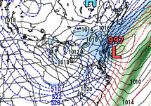
-
January 2026 regional war/obs/disco thread
ineedsnow replied to Baroclinic Zone's topic in New England
on the GFS which trended back north sure.. Euro is a monster though -
That’s not bad at all. We need the drunk hotel sex level of warning. Rarely seen but always a treat.
-
Can somebody post that link for the lwx page with the winter storm confidence, impact matrix? Don't feel like going back looking for it. Thanks