All Activity
- Past hour
-
Coc-a-doodle-goodbye-dews
-
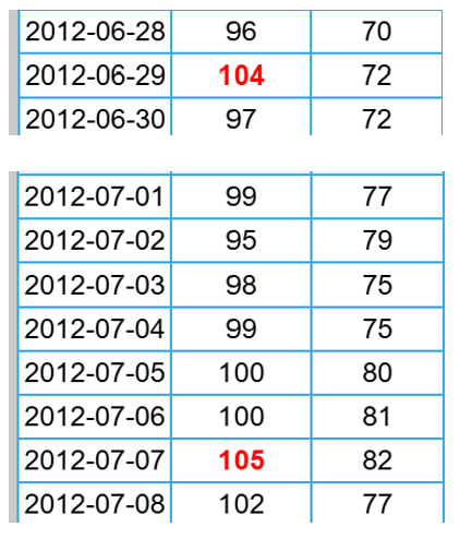
I looked and was surprised to see June was just +0.6 and July +1.4 (DCA). Check out this stretch in 2012 end of June beginning of July. And weren't a lot of people out of power for days after that derecho in late June?
-
 58 degree's on another beautiful drive in to work.
 -
Odd. Harrisburg (MDT) is already -1.6 for August thru yesterday and will end the month much lower. June was only +1.3 and July +2.5. The 3 summer months could easily end averaging barely AN.
-
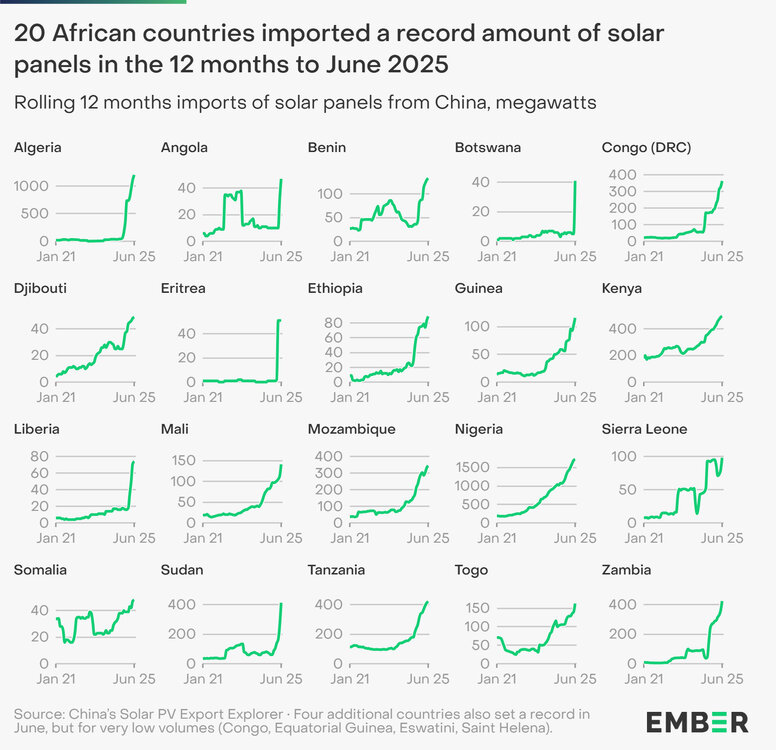
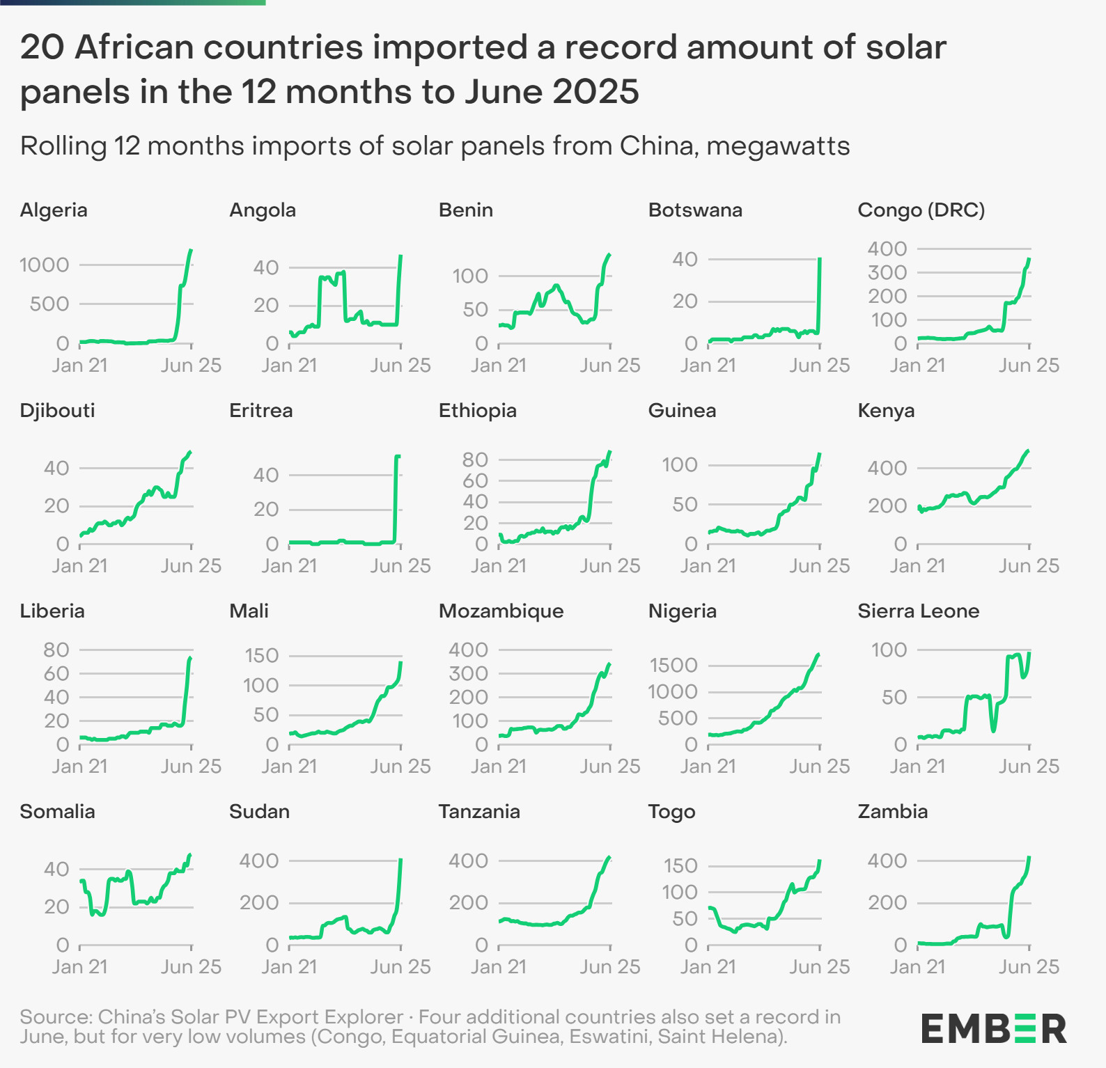
Solar is accelerating rapidly in Africa. This is mainly due to economics, lower cost of solar panels and batteries.
-
49 for me.
-
-
Glorious morning.
-
Low of 51
-
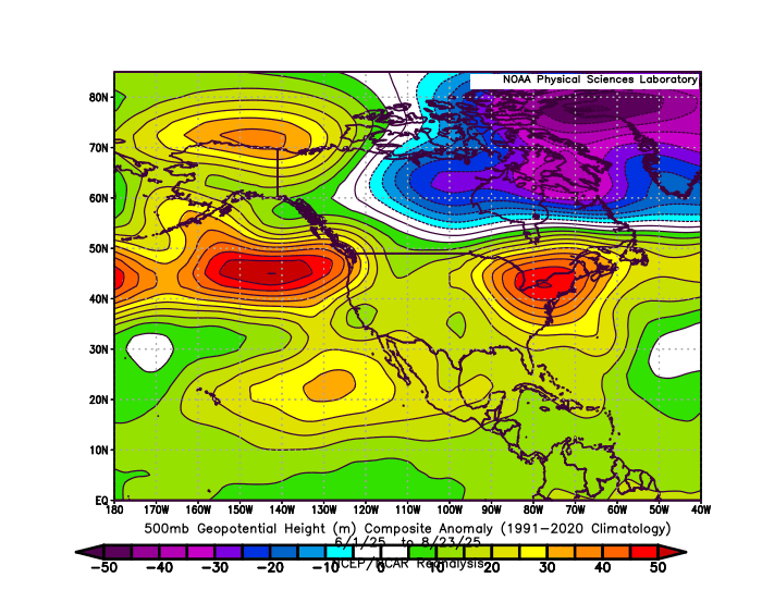
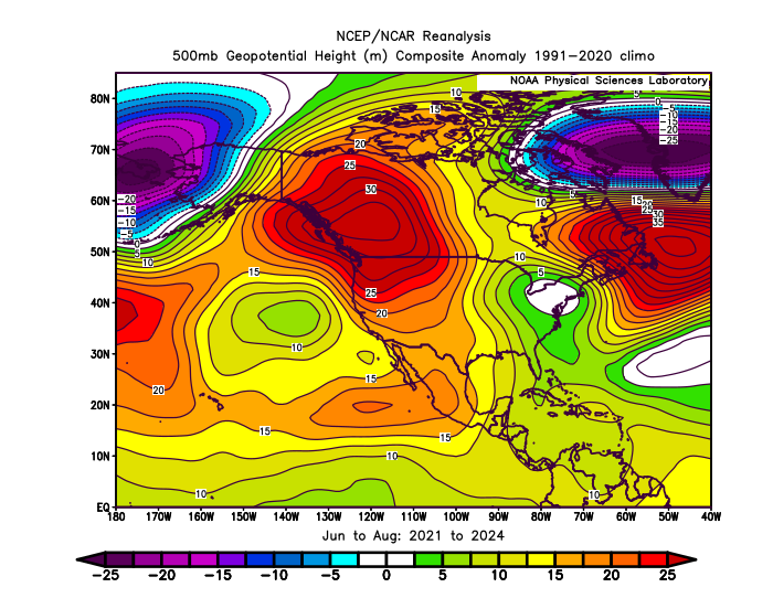
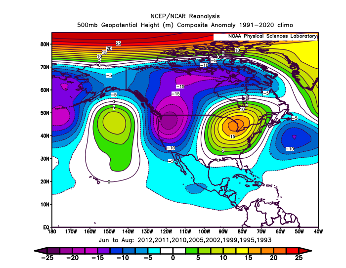
This summer continued the theme of warm to record warm conditions during the 2020s with strong -EPO +PNA patterns. Very warm summers in the Northeast used to be more -PNA +EPO. This is also the strongest Southeast Ridge with this pattern. Warmer Northeast summer composite prior to 2015-2016 Super El Nino
-
I posted a few weeks ago when this cold snap started showing up on the ensembles that I believe late summer/early fall cold snaps are indicative of a better chance of colder winters. I think I said it wasn't a guarantee, but that colder winters often feature them. Time will obviously tell what happens, but it's at least a reason to remain optimistic at this point if you prefer cold/snowy. September's updated monthly forecasts "should" start to hone in one way or the other.
-
August 15 - September 15…. Best month of the year?
-
Chilly low of 45.9. Beautiful sunrise.
-
 We should finish with a slightly cooler August against the warmest 1991-2020 climate normals. But since we have been warming so fast, it would just be average for recent 30 year climate eras. Anytime we get a cooler month in recent years, we eventually see a warm departure of a greater magnitude than the cooler month was. This was the case with the spring warmth after the slightly cooler winter. Also last fall with some cooler conditions early on before we experienced record warmth by October and early November.
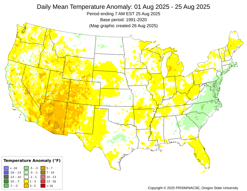
-
 Yep it was in my western sky. It was definitely bright for a split second.
 -
Numerous papers on this new summer warming pattern of cooler in the middle and record warmth in the East and West.
- Today
-
I’m driving to work with the windows down. It feels great.
-
[As of 5:50 AM 8/26] Mt. Mitchell, NC (6,684') is currently 42°F with a Wind Chill value of 36°F.Reminder: It's still August
-
Followup: The Euro (0Z) has this again as a weak low just off Africa. It then eventually comes across to just N of the Leewards as a H moving NW though those details aren’t important so far out on an operational. The EPS (0Z) again has a few TC members from this and they all are headed for a safe recurve from the US. The Icon (6Z) has this again at 120 just off Africa. The GFS (6Z) again doesn’t have this develop. Edit: Unlike the 12Z, the 0Z UKMET doesn’t have this as a TC. The 0Z CMC still has this as a weak low.
-

Central PA Summer 2025
Mount Joy Snowman replied to Voyager's topic in Upstate New York/Pennsylvania
55 when I left the house, may go a tick lower yet. -
Agreed. Most of our summer rains occurred on 7/19 and 8/1. Too much too fast.
-
Dew point 50 ! Exceptional
-
55/52
-

2025 Spring/Summer Mountain Thread
Met1985 replied to Maggie Valley Steve's topic in Southeastern States
What a beautiful morning out! Temp is down to 49 degrees this morning! Going to be a wonderful day on tap! -
 It's not. Ridge rebuilds as tropics get active again


.thumb.JPG.418e8a9a2902ae687ec35ff4bc0e038e.JPG)


