All Activity
- Past hour
-
ive noticed that GGEM has alot of digital ice this year. IS that model broken?
-

Saturday night/Sunday 12/13-12/14 Jawn
RU848789 replied to Ralph Wiggum's topic in Philadelphia Region
Understood, was just hoping such outliers wouldn't be in the snowfall maps you guys generate. Speaking of the PNS's I get while there are "partial" reports before the end of a storm when the storm is still going on, but I always wondered why the partial reports are usually still in the final PNA 12-24 hours after the event is over. For example, with Sunday's storm, there are partial reports from 6 or 7 am, when the storm wasn't over for the vast majority of people in our area until 9-10 am. Why not take these out? By the way, these are minor nitpicks. As I've posted earlier, thought you guys did a great job with this storm and much better than many other media sources, especially in going with 3-5" amounts along 95 and even up through 78 (and saying the most would likely be between 95 and the coast) when many kept with their 1-3" predictions for those areas. -
That was an impressive block. I remember Bob Chill, PSU, and CAPE called that pattern about 10 days out. The pattern happened perfectly. Then I remember the first model runs that showed the storm. The GFS dropped the first bomb. The others followed. That was about a week out. That was the cleanest tracking event I can ever remember. Models just kept showing that huge hit over and over until it hit. I received 20" here.
-
2010-2011 was some of the biggest snow piles my whole time in Long Beach where the old amusement park used to be.
-

December 2025 regional war/obs/disco thread
Typhoon Tip replied to Torch Tiger's topic in New England
impressive hydrostatic correction with that front, no doubt. 20 dm in 6 hours, the bulk of which happens faster than that, too. -

December 2025 regional war/obs/disco thread
weatherwiz replied to Torch Tiger's topic in New England
I wonder if we could see some snow squalls into western areas late Friday afternoon -
It wasn’t just luck, we had a classic west based -NAO in a strong El Niño. Super Ninos are usually warm and boring unless we get that ideal setup, then a HECS is in play.
-
Natural gas closed up nearly 4%, easily its best day since Dec 5th. This is largely based on today’s forecast speculation that the forecasted dominant warmth may not be as widespread, intense, and/or long lasting in the E US as thought yesterday thanks largely to the newly forecasted strong -NAO.
-
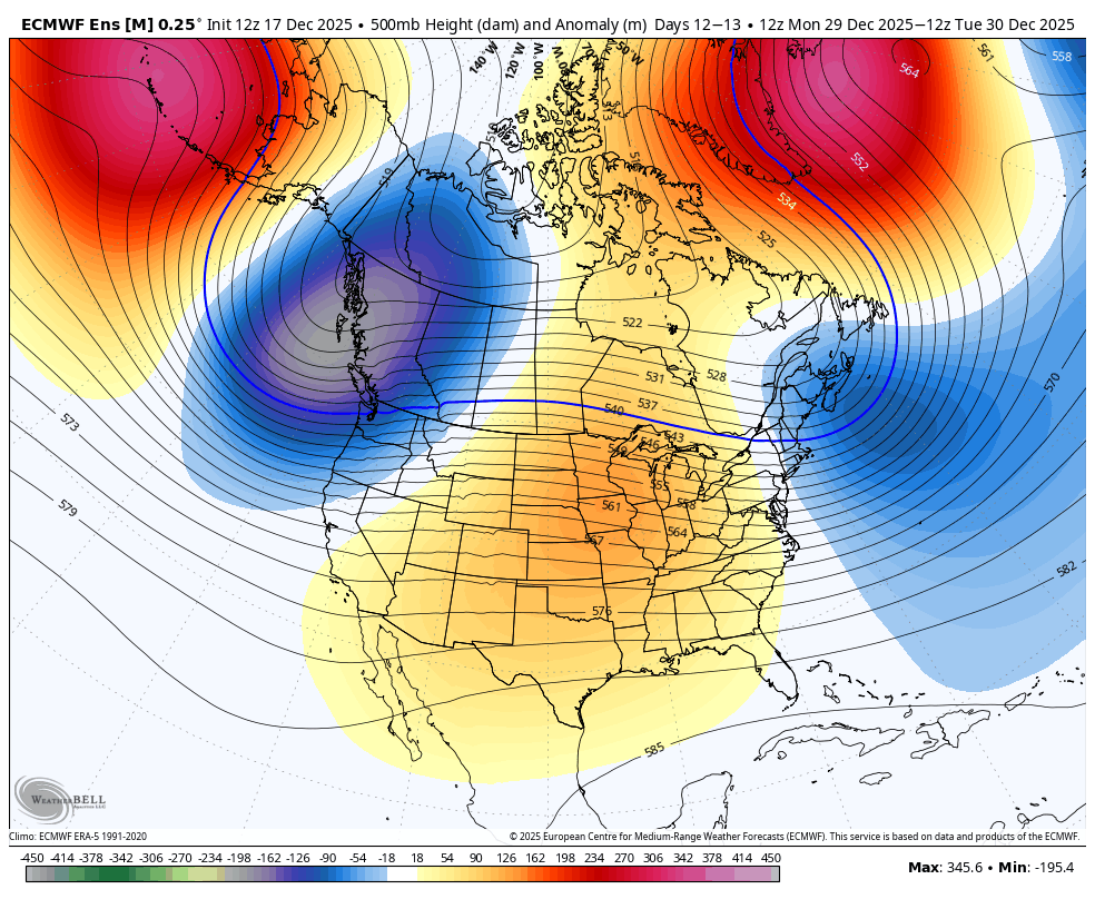
The upcoming -NAO (Christmas week into New Year’s week) is projected to be east-based, in addition, the PAC looks like straight garbage and you have a huge omega ridge dead center of the CONUS, an Aleutian ridge (-WPO) with a +EPO and a very strong -PNA. So if you are looking to stay cool and avoid a “torch” in the east, that will work out fine then, the -NAO will keep the east cool, no “torch”. If you are looking for east coast snowstorms/nor’easters, it looks absolutely awful
-

December 2025 Short/Medium Range Forecast Thread
Daniel Boone replied to John1122's topic in Tennessee Valley
Yep. Still got the usual crowd in Enso forum going complete eventual mild takeover for the east into January. Don S. even. He may change his thoughts with the latest data on the NAO coming in stronger and backing west. They were sold on it being east based. Larry's having to set them straight with latest charts. I won't gloat though as, it's not set in Stone yet. -
Feels straight balmy outside.
-
-
I was referring to this Friday and perhaps one or two days between 12/26 - 12/29
-
The model consensus is currently forecasting the strongest -NAO on Christmas as well as surrounding days since way back in 2010! In stark contrast, these 6 had a strong +NAO: 2011, 13, 15, 16, 23, and 24.
-
pretty significant block showing up later in the month, but the Pacific is kinda trash need to see if the block can become more west based and exert its will on the pattern, perhaps a forcing more of a ridge bridge up top. either that, or the Bering Sea ridge nudging east into AK regardless, nice to see an Atlantic block develop... just need to see some other factors become more favorable for legit shots at snow south of the M/D line

-
hitting 54 today has dissolved whatever snowpack remained from Saturday. Was nice while it lasted, but will take a couple weeks of warmth before (hopefully) a return to the cold
-
December 2025 regional war/obs/disco thread
weatherwiz replied to Torch Tiger's topic in New England
yeah and they seem to target coastal VA/NC. Should be getting a new D3 update though within the next 5-15 minutes. -
December 2025 regional war/obs/disco thread
Typhoon Tip replied to Torch Tiger's topic in New England
synoptic wind driven events seldom materialize or verify as advertised. That's why I lean needing the convective assist - hence the Marginal. I just checked btw and they've already gone there in their d-3 sev storms outlook - tho the verbiage is rather bland. -
December 2025 regional war/obs/disco thread
weatherwiz replied to Torch Tiger's topic in New England
If the fun weather can't come to you, you go to it. I don't think I've ever seen a civil emergency message for wind before. Sure its happened but must be rare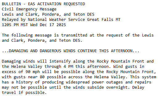
-
December 2025 regional war/obs/disco thread
weatherwiz replied to Torch Tiger's topic in New England
NAM/GFS do have an insane LLJ at 925 materialize across eastern CT/RI/E MA through Friday morning...so something to definitely keep an eye on if that can be tapped into. This does happen to coincide with the leading edge of the main rain area too, however, there is a stout inversion too -

December 2025 regional war/obs/disco thread
mahk_webstah replied to Torch Tiger's topic in New England
I tend to like those messy systems in southern New England -
Good post. To put a fine point on the synoptic/orographic nature of this year, I am at 14.6" snowfall total here in Charlotte at 285'. With 4" OTG and a SWE of 0.6"
-
December 2025 regional war/obs/disco thread
Typhoon Tip replied to Torch Tiger's topic in New England
mm I'm thinking more along the lines of synoptic forcing/wind problems that are then entangled with convection along what's inevitably going to be a ribbon echo squall sinuously side winding across the area. I guess wind watch headlines may cover this come to think of it. Plus... any "subtle" discrete nature to leading convective elements that are embedded in the misty wind smearing rad wash region - dirty warm sector... Those'll be whisking along within a llv jet. Those could snap troubled limbs. NAM is a tad more aggressive with this llv wind max than the Euro ( 12z ) ...haven't looked that GFS. But the NAM indicated 65+kts at 925 mb between HFD-BED! That's a whopper if it's for real. But even the Euro has this wind maxim moving NYC to SE zones/clipping at 55 to 60. A compromise puts a potential momentum/gust problem across the bulk of the area. There's still still 2 days to tune this potential. But the soundings start to look more barotropic as this is all occurring and that means we scale back the protective inversion stuff... -
Cold down here in the holler at head of the crick with high of 49 and low of 21. Not a big departure but another consecutive negative 2” remaining snow over at Frederuck house doing its job, 42 max so far there
-
December 2025 regional war/obs/disco thread
weatherwiz replied to Torch Tiger's topic in New England
I wouldn't be shocked if that ridging in the south is too smoothed out too. I would wager probably more of a ridge axis into the upper Mississippi Valley which could then argue for some lower heights in the Northeast The overall structure of that trough across western Canada's coast will be a big player too


.thumb.jpg.ad3a2e31d30aff035044689b311a0540.jpg)


