All Activity
- Past hour
-
 93/72
93/72 -

2026 Spring/Summer Mountain Thread
Maggie Valley Steve replied to Buckethead's topic in Southeastern States
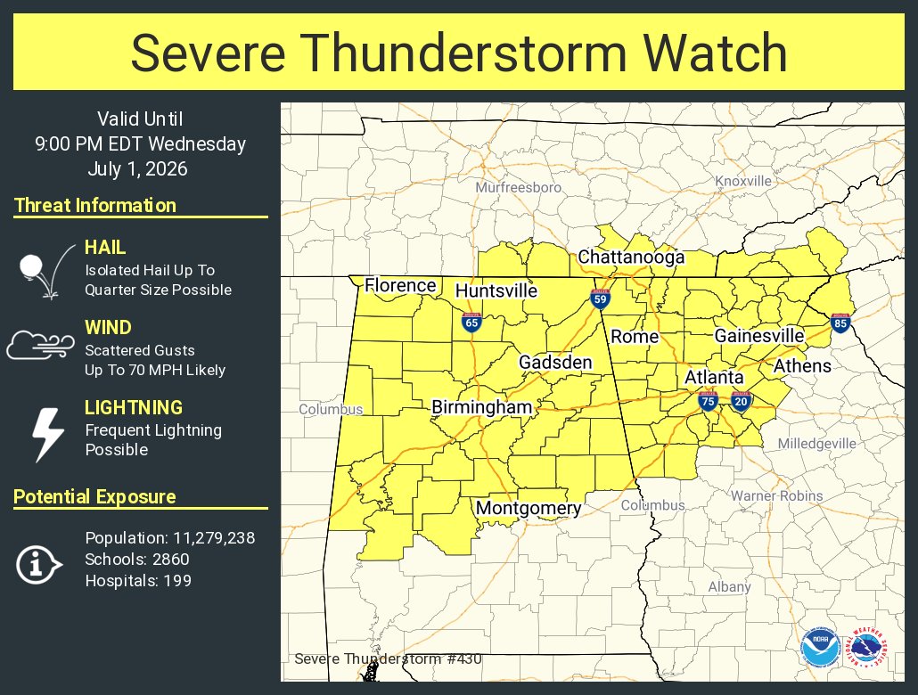
Severe Thunderstorm Watch for portions of the SW Mountains.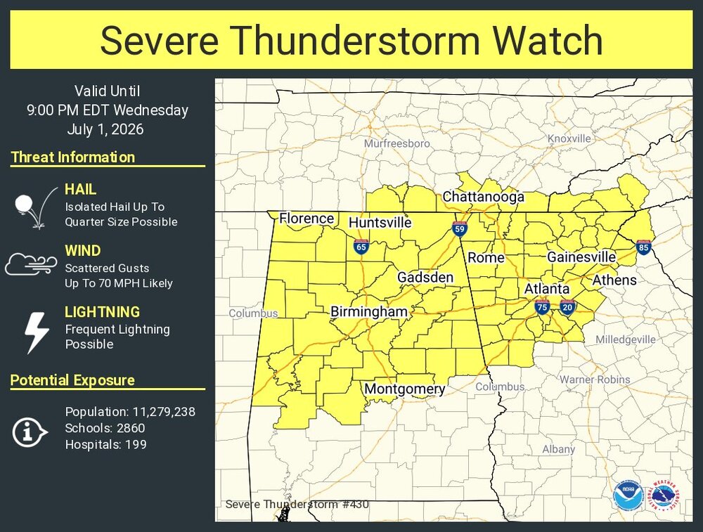
-
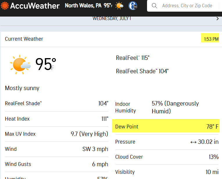
Damn, already blew past the predicted heat index. Current conditions at Wilmington Airport (KILG) Lat: 39.67°NLon: 75.61°WElev: 72ft. Fair 95°F 35°C Humidity 54% Wind Speed S 7 mph Barometer 30.01 in (1016.1 mb) Dewpoint 76°F (24°C) Visibility 10.00 mi Heat Index 108°F (42°C) Last update 1 Jul 1:51 pm EDT
-
Day two has marginal risk in ky Virgina Carolinas Alabama Mississippi and slight risk in south east tn parts of Carolinas north Georgia northeast Alabama for tomorrow 5-15% wind and 5% for hail .
-
Probably need 10'' here to green things up in these parts.
-

E PA/NJ/DE Summer 2026 Obs/Discussion
JTA66 replied to PhiEaglesfan712's topic in Philadelphia Region
I'd pay good money to have that cell over Allentown drift down the NE Extension. 96F/DP 78F -
Euro isn't showing much for the 4th. Hopefully it will be dry for fireworks.
-
Plenty of them today
-
DCA getting river winded to death and still managing the mid 90s is a testament to the urban heat island.
-
Hrrr has nothing so we'll see
-

E PA/NJ/DE Summer 2026 Obs/Discussion
LVblizzard replied to PhiEaglesfan712's topic in Philadelphia Region
95/75 at KABE. Heat index of 107. Actually feels kinda okayish in the shade but the sun is unbearable. -
95/109
-
95/75 10 mile bike ride . The heat is legit. Be careful and smart
-

Central PA Summer 2026 Discussion/Obs Thread
mahantango#1 replied to Voyager's topic in Upstate New York/Pennsylvania
Had a dewpoint earlier of 86 -
94/73 here. Oppressive
-
 Highs so far
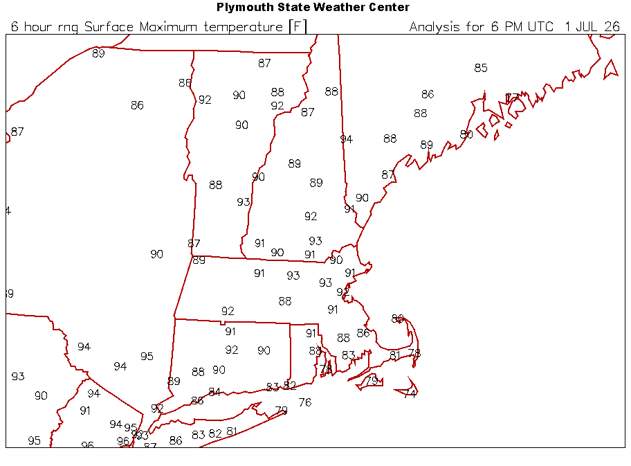
-
97 feels like 111. Tomorrow going to be brutal
-

E PA/NJ/DE Summer 2026 Obs/Discussion
Hurricane Agnes replied to PhiEaglesfan712's topic in Philadelphia Region
There is some nasty cell sitting over Wilkes-Barre! IMBY it's currently 94 with an obscene dp of 81.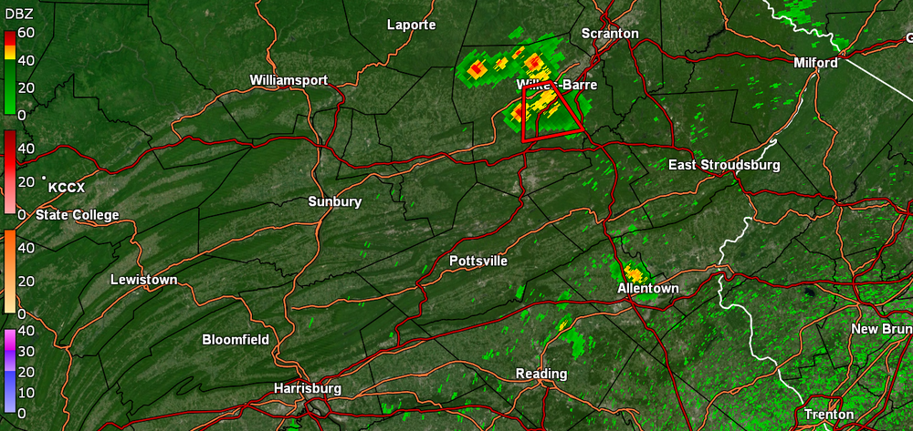
-
Gross this afternoon. Rutgers stations already have 110+ heat indexes showing up in spots.
-
GENT - WEATHER MESSAGE National Weather Service Baltimore MD/Washington DC 132 PM EDT Wed Jul 1 2026 DCZ001-MDZ004>006-008-011-013-014-016>018-503>508-VAZ037>040-050-051- 053>057-501-502-505-506-526-527-020300- /O.UPG.KLWX.XH.A.0001.260702T1500Z-260704T0000Z/ /O.NEW.KLWX.XH.W.0003.260703T1400Z-260704T0000Z/ /O.NEW.KLWX.XH.W.0002.260702T1400Z-260703T0000Z/ /O.CON.KLWX.HT.Y.0004.000000T0000Z-260702T0000Z/ District of Columbia-Frederick-Carroll-Northern Baltimore-Cecil- Southern Baltimore-Prince Georges-Anne Arundel-Charles-St. Marys- Calvert-Northwest Montgomery-Central and Southeast Montgomery- Northwest Howard-Central and Southeast Howard-Northwest Harford- Southeast Harford-Albemarle-Greene-Madison-Rappahannock-Orange- Culpeper-Fairfax-Arlington/Falls Church/Alexandria-Stafford- Spotsylvania-King George-Northern Fauquier-Southern Fauquier- Western Loudoun-Eastern Loudoun-Northwest Prince William-Central and Southeast Prince William/Manassas/Manassas Park- 132 PM EDT Wed Jul 1 2026 ...HEAT ADVISORY REMAINS IN EFFECT UNTIL 8 PM EDT THIS EVENING... ...EXTREME HEAT WARNING IN EFFECT FROM 10 AM TO 8 PM EDT THURSDAY... ...EXTREME HEAT WARNING IN EFFECT FROM 10 AM TO 8 PM EDT FRIDAY... * WHAT...For the Heat Advisory, heat index values up to 107. For the first Extreme Heat Warning, dangerously hot conditions with heat index values up to 111 expected. For the second Extreme Heat Warning, dangerously hot conditions with heat index values up to 112 expected. * WHERE...Portions of DC, central, north central, northeast, northern, and southern Maryland, and central, northern, and northwest Virginia. * WHEN...For the Heat Advisory, until 8 PM EDT this evening. For the first Extreme Heat Warning, from 10 AM to 8 PM EDT Thursday. For the second Extreme Heat Warning, from 10 AM to 8 PM EDT Friday. * IMPACTS...Heat related illnesses increase significantly during extreme heat and high humidity events. Hot temperatures and high humidity may cause heat illnesses.
-
Slight and marginal risk issued for southeast today reaches far up as high as near i40 5-15% damaging non hatched wind and 5% hail non hatched .
-
 Having someone die on your property is definitely something insurance companies want to see.
 -
88/73. Everything nice and lush. The rain last night helped green things up
-

E PA/NJ/DE Summer 2026 Obs/Discussion
Birds~69 replied to PhiEaglesfan712's topic in Philadelphia Region