All Activity
- Past hour
-

Central PA Summer 2026 Discussion/Obs Thread
mahantango#1 replied to Voyager's topic in Upstate New York/Pennsylvania
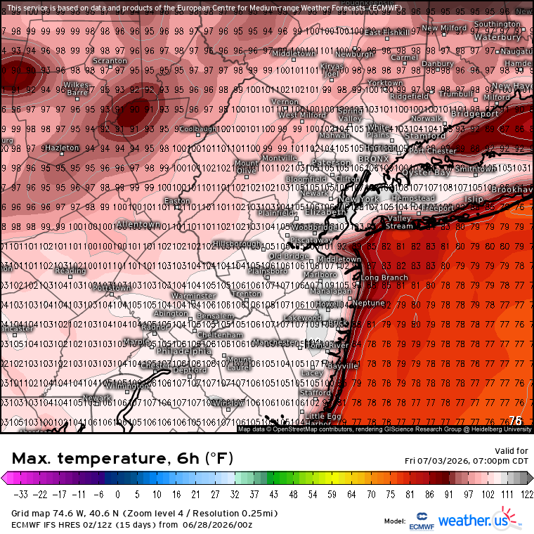
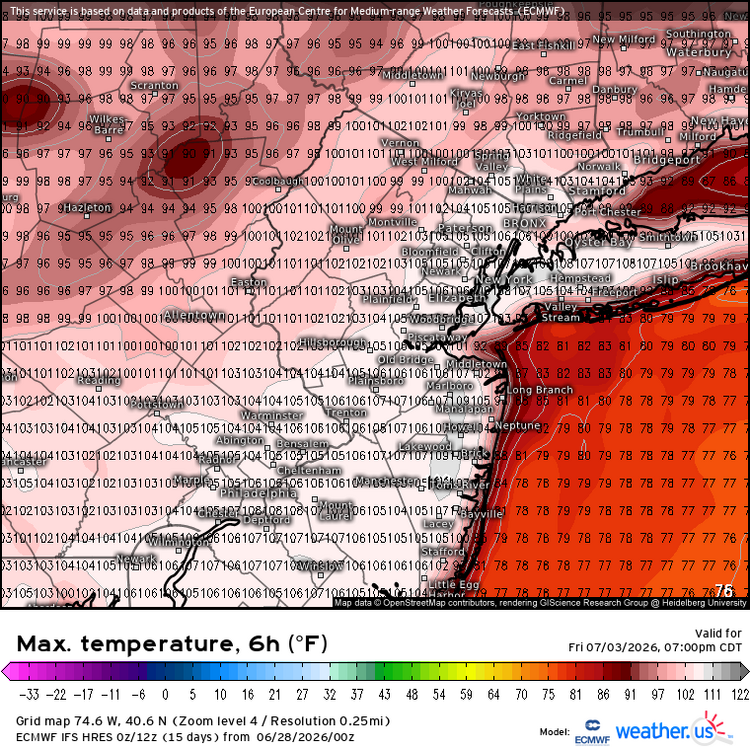
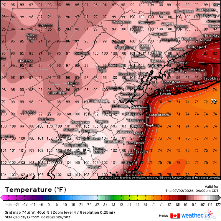
.CLIMATE... Triple digit max temps are forecast in the Lower Susq Valley (LSV) on Thursday and Friday bookended by upper 90s Wednesday and Saturday. The last time Harrisburg observed consecutive days with maxT greater than or equal to 100F was back in 2011 on July 21-22. The record number of consecutive days with maxT >= 100F is 3 and has occurred 5 times: (all in the month of July) 1999-07-16 to 1999-07-18 1999-07-04 to 1999-07-06 1991-07-19 to 1991-07-21 1966-07-02 to 1966-07-04 1936-07-09 to 1936-07-11 The last time Harrisburg hit the century mark was July 16th in 2024. Prior to that, it was July 19th in 2020. Harrisburg averages 1 day annually with a maxT >100F. The most number of days observed in a year is 6 in 1999. -
Central PA Summer 2026 Discussion/Obs Thread
mahantango#1 replied to Voyager's topic in Upstate New York/Pennsylvania
And in 6 months or so our heating systems will be getting a workout. -
Like the "29 inches of snow that fell at BWI in 2016. Bogus. I measured 21" at BWI. The biggest official snowstorm is Bogus. Feb 2010 was the GOAT.
-
Disgusting
-
From Junorch to Jultorch...
-
The AFD mentioned that the all-time warmest low for Annapolis was 92, on 7/7/94. That is what was in the official records, but the observation has to be some sort of glitch. Patuxent River had a low of 74 on that date. That 92 should never have made it into the AFD; it's so clearly bogus it doesn't pass the smell test!
-
ALEET ALEET I’ve had a sprinkle!
-

Junorch obs and discussion 2026
Damage In Tolland replied to Damage In Tolland's topic in New England
Danger ahead -
0.02". Not enough to skip watering the garden.
-
All 3 major models are now showing 105° potential for the warmest areas this week. Just goes to show what is possible when drought feedback coincides with such a strong ridge and a warming climate. While the sample size for super El Niño events is small, this would be a first for a developing El Niño this strong. The other examples of heat approaching or exceeding 105° at the warm spots during July were La Ninas like 2011, 2010, 2001, 1966, and some years closer to neutral. So the heat is getting an early start with this super El Niño. Past super El Niño events waited until the fall through the following summers for their greatest warmth relative to the seasons.
-
It is raining!!!!
-
BOX has 104° in the point click for downtown Boston. lol
- Today
-

2026-2027 Super El Nino
bluewave replied to Stormchaserchuck1's topic in Weather Forecasting and Discussion
Plenty of more rural to suburban stations outside the main I-95 urban corridor are high up on the list for most 90°days on record through the end of June from Eastern PA into New England. -
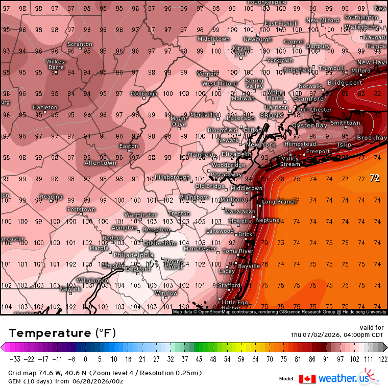
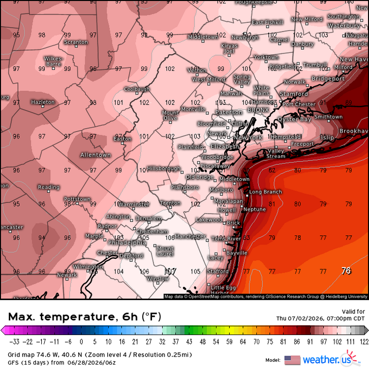
Holy crap…… Thursday Sunny and hot, with a high near 103. West wind 5 to 8 mph. Thursday Night Mostly clear, with a low around 76. West wind 3 to 5 mph. Friday Sunny and hot, with a high near 101. Northwest wind 3 to 8 mph.
-
Some special Miami style nights coming up. Forecast low temperatures in the lower 80s across NE NJ and NYC Thu night and Fri night. Heat index values not expected to drop below the lower 80s in NYC and immediate surrounding areas Wed night through Fri night, making for little to no recovery from heat stress Wed through the day Sat.
-

Central PA Summer 2026 Discussion/Obs Thread
pawatch replied to Voyager's topic in Upstate New York/Pennsylvania
63 degrees this morning with yesterday’s high of 75 degrees. We picked up .20” of rain yesterday. It’s been kind of hit and miss. Sometimes just getting skirted by the bulk of the storm. But at lest picking up some rain. Looks like Tuesday we see our start of the heat. Then 3 days of close to 100. Looks like the AC will be getting a good workout. Probably just stay inside them 3 days. -

E PA/NJ/DE Summer 2026 Obs/Discussion
Hurricane Agnes replied to PhiEaglesfan712's topic in Philadelphia Region
I know this won't be welcome in this group - Picked up 0.09" of rain yesterday for 6.25" for the month so far, and had a high of 76 after a 68 low. Currently 69 with dp 67. -
Forget all your typical heatwave songs. Time for us to enjoy the summer like the manly men we are. Anyone got an extra scooter? We’re in this for a while better make the best of it lol
-
It's showing 105 degrees for Friday. That would be... something.
-

Late May/June 2026 Medium/Long Range
Stormchaserchuck1 replied to JenkinsJinkies's topic in Mid Atlantic
Baltimore city forecast Thursday Sunny and hot, with a high near 106. Thursday Night Mostly clear, with a low around 81. Friday A slight chance of showers and thunderstorms. Sunny and hot, with a high near 106. Chance of precipitation is 20%. -
2026-2027 Super El Nino
Stormchaserchuck1 replied to Stormchaserchuck1's topic in Weather Forecasting and Discussion
Good chance for an -AO this Winter in my opinion! The correlation to reverse conditions there between the warm and cold seasons has been strong since 2012! I think the period looked at is through September though. -
2026-2027 Super El Nino
Stormchaserchuck1 replied to Stormchaserchuck1's topic in Weather Forecasting and Discussion
That's the NAO. I think the folder code is always pna. Here's PNA: cpc.ncep.noaa.gov/products/precip/CWlink/pna/norm.pna.monthly.b5001.current.ascii.table -
Need this here. Nearly 30k bolts detected in 30 minutes lol
-
My response to calls to bring back Showalter specifically: Hypothetically speaking...Bring Showalter back and then what...still not win a WS that we all want? Lol Sure the regular season may go better...but we would still not have a ring as Showalter fell short in the playoffs his entire career. So that would be a no for me!
-
Tell me can you feel it?