All Activity
- Past hour
-
I have been planting my entire pollinator buffet garden (annuals edition) between light showers. My seedlings a bit overdue but ok and these conditions are awesome.
-
A 75:1 ratio….sounds almost impossible? But I guess not. That’s truly impressive.
-
Love a good slop fest pasting. Sun angle is going to be a thorn in our side this time of year.
-
Another cell just popped up and is over downtown Atlanta in almost the exact spot as the storm that created all the flooding issues yesterday. This is actually moving, though, and the rain rates seem to be less than they were yesterday.
-
1.23" last 24. Expecting 1 - 2 inches additional later this afternoon and tonight.
-
BrianD said it best. A big pond, some latitude and it's a different world. Recovered nicely today with a high so far of 54, has since dropped a couple degrees with a light ne breeze. Better than yesterday.
-
Tuesday and Wednesday should be quite warm next week (though obviously nothing like this week). Wednesday though we'll see a front moving south so there will be a gradient within the region so northern areas may only be a one day ordeal.
-
May 2020 came very close in Central Park.
-
It’s been so long since we’ve had the radar popping in the afternoon like this
-
 Looks like the rubber band is about to snap back.
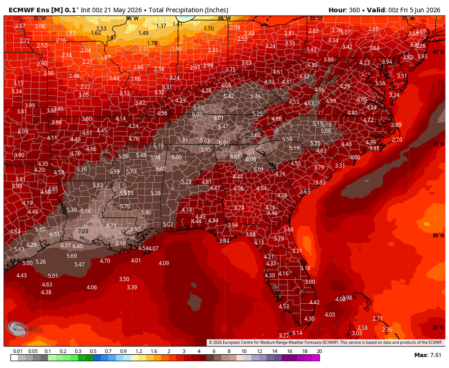
-
Drier than a popcorn fart here…
-
Anyone have an idea of when the last time was around here that a monthly record low was tied or broken?
-
Pop up storms starting to fire up in the western Piedmont and cumulus clouds building. Cap seems to be breaking down a little ahead of schedule
- Today
-
Sucks .84” on the day
-
I know everyone’s excited about the rain but I really don’t like how the tropics are starting to fire up at the end of the model runs. It would be our luck to go from drought to a wet period followed by tropical mischief.
-

2026-2027 Strong/Super El Nino
Stormchaserchuck1 replied to Stormchaserchuck1's topic in Weather Forecasting and Discussion
New CPC Winter forecast fwiw. In the last 15 years they actually don't verify as good as you think they would at +2 month lead. Not sure how they do at +7 month lead: -
We were wet(rained) a lot of the morning here…drying out now.
-
Beautiful 59F, House is finally cooling off. The heat is brutal on the roof of my place. Light rain currently.
-
2026-2027 Strong/Super El Nino
Stormchaserchuck1 replied to Stormchaserchuck1's topic in Weather Forecasting and Discussion
New CPC Summer seasonal is much warmer than classic developing Strong Nino climo -
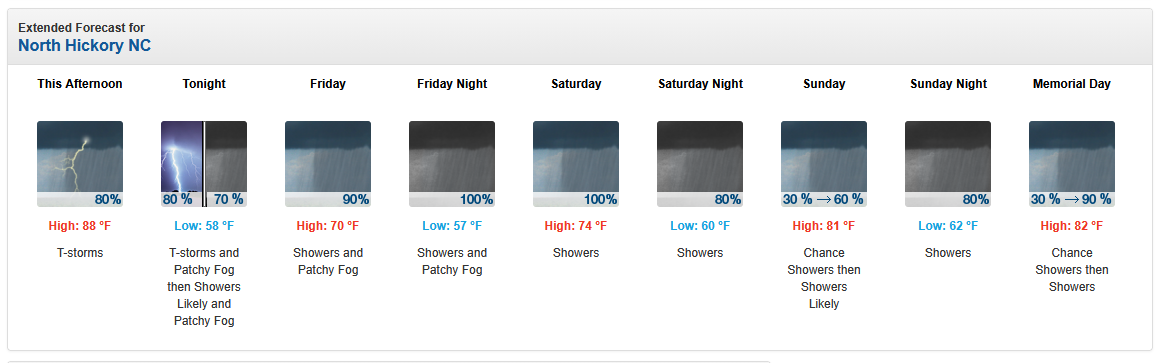
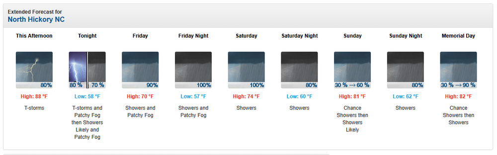
Haven't seen a forecast like this in a long time. Let's hope it materializes...
-
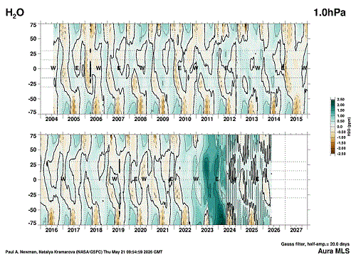
Found the site where stratospheric WV is shown at the various levels starting from the tropopause up to the top of the stratosphere. https://acd-ext.gsfc.nasa.gov/Data_services/met/qbo/h2o_mls.html My question is...Has the Hunga Tonga eruption in Jan 2022 greatly affected the climate system over the past few years with such a strong increase in WV within the stratosphere? We know that very large eruptions do affect the system for a few years, but this one was so different than the usual with such a large volume of WV injected so high up. It was awesome enough with the pressure waves circling the globe many times. Here's a slide show of the charts starting from the top down through the stratosphere into the tropopause.
-
monthly record highs were set with the heat wave. any monthly record lows on the horizon?
-
First 90 degrees day here yesterday, reached the mid 90s. Also 1.36 inches of rain. Currently 58 degrees.
-

Chester County PA - Analytical Battle of Actual vs. Altered Climate Data
chubbs replied to ChescoWx's topic in Climate Change
Getting rid of the station moves is an improvement, but you are still using "fake math" by not maintaining a constant baseline in Chester County. There is only one station from the 1970 network that remains in 2025. On average the the 2025 stations are colder: DEOS vs COOP, or East Nantmeal vs Devault for instance. You are distorting the raw data by changing the station population. My table on the other hand is an unbiased apples to apples comparison, exactly the same data treatment for Chesco and Philly. That shows no difference in warming between Chesco and Philly Airport.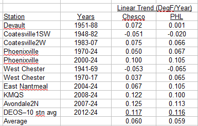
-
2026-2027 Strong/Super El Nino
Stormchaserchuck1 replied to Stormchaserchuck1's topic in Weather Forecasting and Discussion
Really a strong graduation. It's still intensifying in the far east