All Activity
- Past hour
-
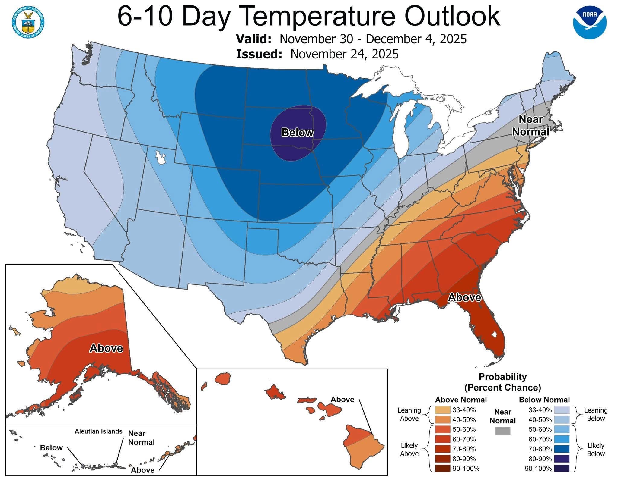
i didn't post a pivotal weather map though
-
Yea he brought up some good points: our economy and life-style is currently dependent on oil, and oil is running out. However. he's wrong that there is no alternative. Electric vehicles are out competing combustion vehicles in an increasing number of markets and getting cheaper all the time. Meanwhile the best oil reserves are increasingly depleted. Its not going to get better for oil.
-
The default setting is no missing days, so it treats any missing date as ending the streak. You have to allow some number of missing days to avoid that.
-
Is that the Op you’re talking about? I saw the ensemble mean.
-
There has been a +PNA in Jan for all 11 cold ENSO winters that had a -PNA in Dec since 1983-4: -1983-4: -0.31 to +0.97 -1984-5: -1.60 to +1.63 -1996-7: -1.23 to +0.63 -1998-9: -0.09 to +0.16 -2008-9: -1.41 to +0.61 -2010-11: -1.78 to +1.29 -2012-3: -1.01 to +0.55 -2013-4: -0.86 to +0.97 -2016-7: -0.35 to +0.28 -2021-2: -2.56 to +1.01 -2022-3: -0.66 to +0.22 ———— What kind of PNA are you expecting in Jan?
-

November 2025 general discussions and probable topic derailings ...
CoastalWx replied to Typhoon Tip's topic in New England
Yeah some deep cold in SE Canada. -
Believe the table is calculating electric energy out vs fossil energy in over the powerplant lifetime; i.e., coal (or gas, oil) used to generate power is included. Fossil fuel use during operation of the wind turbine is also included. Agree that society gets an energy payback from use of coal or oil. The problem is that once burned the coal it is gone forever. In-any-case wind has a good energy payback. Here's an extensive study from Europe covering 33 different kinds of turbines. The median payback period is 6 months. Note that the energy payback for wind has to be good. Its the cheapest source of electricity in windy areas like the great plains. If it didn't pay back it wouldn't be cheap. https://www.sciencedirect.com/science/article/abs/pii/S0196890421005100
-
Heh...see what ya did there, lol
-
I understand and feel the frustration but I can’t get with jumping in mid-November. Things change too much, though admittedly it rarely feels like they change positively. I realize this kind of winter doesn’t satisfy you much, but when it can just takes one storm to hit climo, it’s way too early to quit
-

November 2025 general discussions and probable topic derailings ...
ineedsnow replied to Typhoon Tip's topic in New England
Usually a little high on.amounts compared to other sites.. but we take!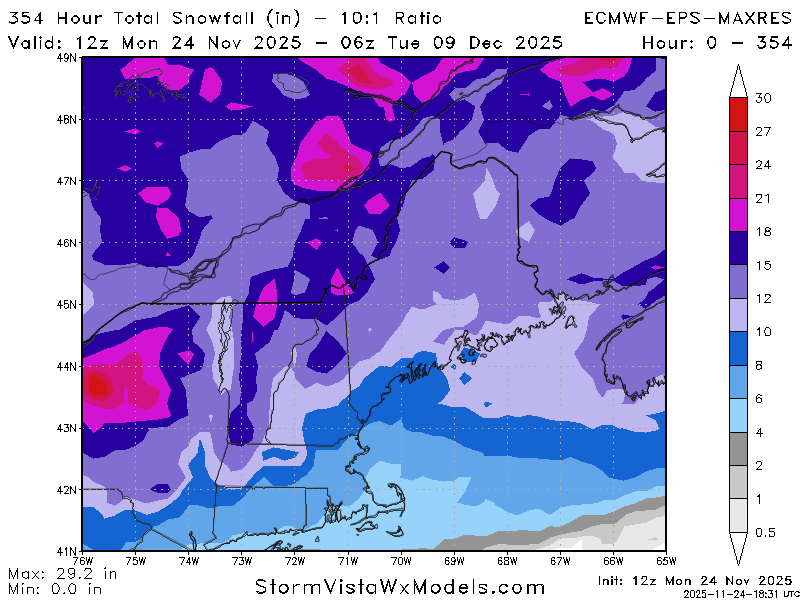
-

-
We're in a tenuous spot. You wait all year for winter and then we torch like it's nothing. Meanwhile the atmosphere has concepts of a pattern for snow that's perpetually two weeks away.
-
This is awesome!!
-

November 2025 general discussions and probable topic derailings ...
ORH_wxman replied to Typhoon Tip's topic in New England
WPO/EPO cold press is really evident after about the 2nd of December. We’ll see if we can cash that in for some snow events but I’m fairly optimistic right now. I’m not full-on weenie mode like you’d see with a PNA ridge going up to Yukon Territory, but given the Niña background state and strong -PDO, this is a pretty good look for us in early December. Doesn’t mean a whole lot yet, but also I noticed the EPS mean is creeping up little by little for snowfall. It has about 3-6” across SNE now in that Dec 3-9 period. So it def has some members in there producing decent snow. I do like seeing the consistent low height max in Quebec/Labrador on that 5-day mean H5 anomaly between Dec 3-8. It’s a very good spot to hold in those arctic highs during a SWFE. We haven’t seen much of that since the glory days.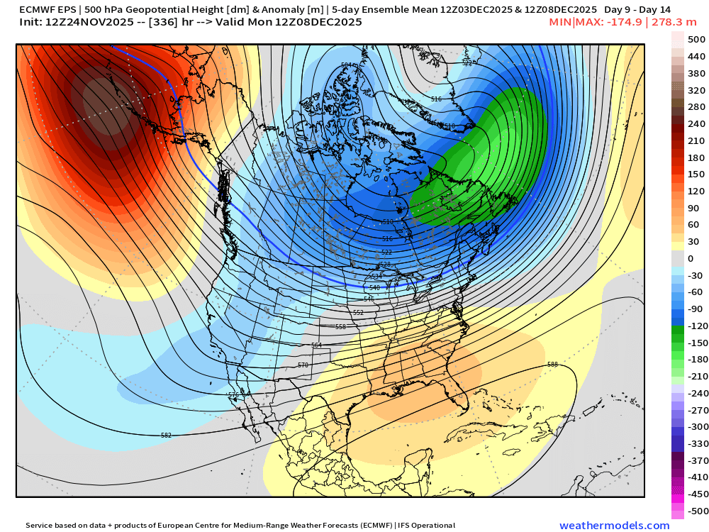
- Today
-
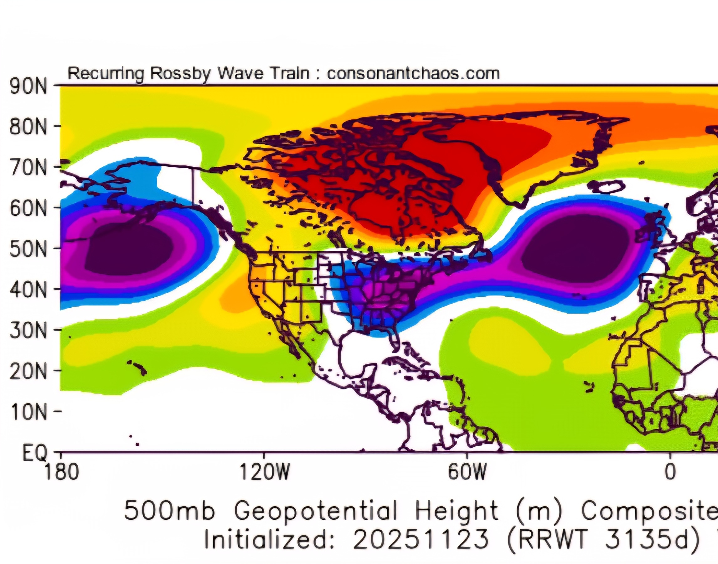
RRWT model, which is based on rosby waves (Josh Herman's model), has persistently shown a cold Christmas for a good while. This was yesterday's update for dates Dec 24-28: 500mb

-
It falls at the end of the run. It takes a slp system far enough to our west and a cold High in Quebec doesn't budge as it goes to our west and weakens. Cold air holds on and probably ends as drizzle or -rn. For those old enough to remember, Thanksgiving Sunday night into Monday morning 1978 had a similar setup and dropped 3.5+" around BWI and IAD. DCA was closer to 2" I think.
-

December 2025 Short/Medium Range Forecast Thread
Carvers Gap replied to John1122's topic in Tennessee Valley
Glad @John1122reminded us of the basketball game. Wow. Insanely good on offense today. You all know that I like the Euro controls. I went back to the last 7-8 runs. They are alternating almost perfectly from warm to cold...every other day. Well, here is today's, and this has support across the 12z suite(even though this was a 0z run). This is a 30 day map for the month of December. Lot of big troughs swinging through w/ the SER flexing as the cold retreats. To me at least, that seams like a reasonable pattern compromise. -
Very much positive trends today across the board.
-
November 2025 general discussions and probable topic derailings ...
CoastalWx replied to Typhoon Tip's topic in New England
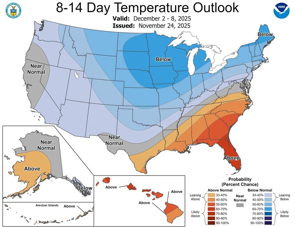
EPS and Euro AI ensemble are interesting. Seems like they hint at overrunning maybe 3-5 of December? After that the PV tries to sink through Canada while we have the SW US trough. Despite that trough, it would not shock me if there is something Deep South winter briefly before maybe we grab something perhaps the 7th on. It’s all just sort of speculation, but sometimes the 24hr ensemble mean precip fields can hint at storm tracks. -
Hey western MD folks:
-
 Is that a Char?
 -
Agree. Haven't had a chance to look at anything but the 12Z GFS today but the last few panels on the long range look pretty good to me.
-
Deep snows in winter up there