All Activity
- Past hour
-
Given the amount of rock salt and calcium they dumped all over the roads yesterday, I doubt we see a big widespread freezing rain fest. It takes very anomalous conditions for those anyway and that’s why they are so rare around here
-
I went over to TT and put the 5H anomalies in motion with the slid function. I looks like the lowest anomalies backed in from the east and not from west to b east. Idk if it makes a difference, but I was expecting it to move from west to east. I'm not saying it's bad, because I don't know. Maybe a red tagger can chime in. https://www.tropicaltidbits.com/analysis/models/?model=eps®ion=us&pkg=z500a&runtime=2025122800&fh=12
-
BWI: 37" DCA: 19.5" IAD: 14.5" RIC: 24" SBY: 18"
-
Yep, that’s all we can take away at this moment. Jan 5-12 is still what I’m cautiously optimistic about, and the pattern still looks good after. There may be a couple/few days where we relax or warm up, but we have not lost this yet.
-
Declaring the second White Christmas in a row is much more complex than just measuring snow. At 7am Christmas morning I would say for sure it was a white Christmas. The viewable area from my house had at least a one to two inch snow cover over 80% of the land mass which is my criteria for snow cover. However as you yourself stated our current snow has staying power, the snow consistency from the 23rd did not. By noon on Christmas Day snow coverage was less than 50% and by sunset 20%. How is that really a White Christmas? And there we have the White Christmas Paradox. How is it a white Christmas when more than half the day is green? The Fermi paradox may be answered before this. I'm considering changing my declaration of this year being a White Christmas. No question about today's snow cover. After a morning low of 9 snow cover at 5.5. I believe the consistency and LE of the current snow pack will easily survive our rain tonight and mid 40's tomorrow.
-
-2 at AFN while ORH is 20F. About as fake as it gets, lol. But there will def be some stubborn cold overnight tonight that will cause icy spots.
-

Ice Ice Baby December 28-29 Storm Discussion
wx2fish replied to Baroclinic Zone's topic in New England
Skeptical of the HRRR, but verbatim the 12z run is 3/4" qpf as freezing rain across SNH. My guess is its a little too cold, and itll be a faster rise to around 32 for many. But, something to montior today. -
It’s a good look & the key is that it is sustainable.
-
.
-
Upper peninsula is gonna get utterly rocked tonight
-

Central PA Winter 25/26 Discussion and Obs
paweather replied to MAG5035's topic in Upstate New York/Pennsylvania
This would be nice! -

January 2026 regional war/obs/disco thread
ORH_wxman replied to Baroclinic Zone's topic in New England
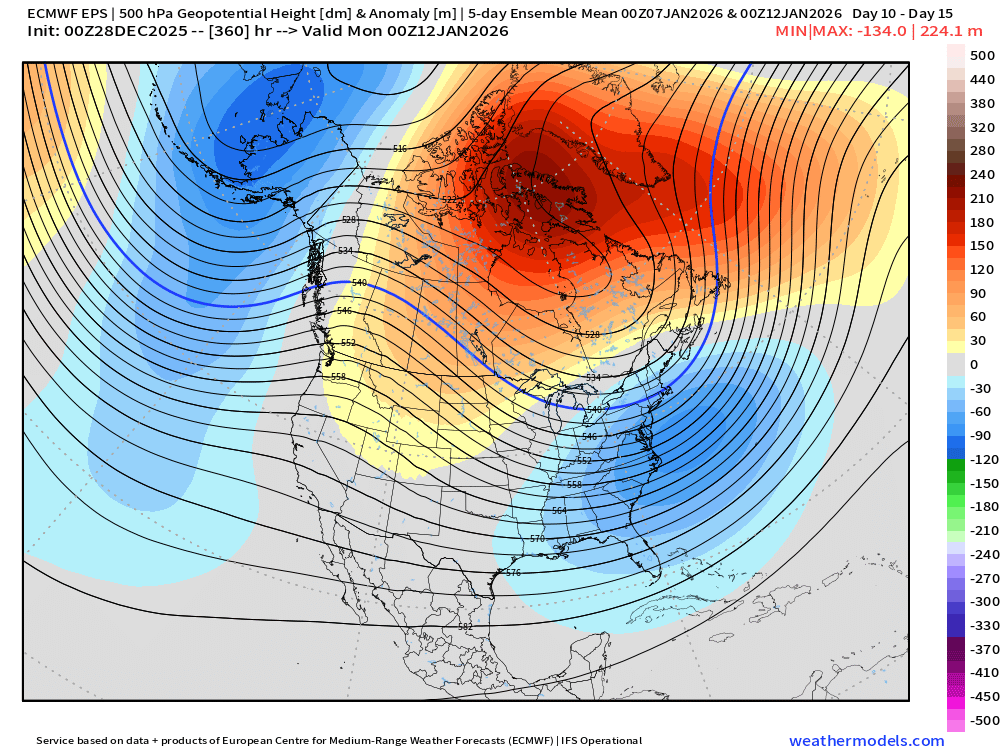
Looks too flat now for much if anything. Maybe it comes back but I’d forecast flurries right now. Pattern looks pretty awesome though beyond that. Here’s day 5-10 and then day 10-15 respectively on EPS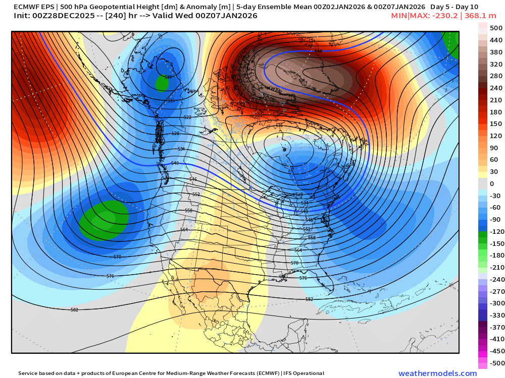
-

January 2026 regional war/obs/disco thread
Damage In Tolland replied to Baroclinic Zone's topic in New England
You’ll be on a hot sweaty beach. So you miss out on a couple inches. No biggie -
Morning low of 9 currently 12.4 in the HV.
-

January 2026 regional war/obs/disco thread
moneypitmike replied to Baroclinic Zone's topic in New England
A dusting with lollies of a heavy dusting. -
9 here this AM in the Berkshires, currently 20 back home in HPN.
-

January 2026 regional war/obs/disco thread
CoastalWx replied to Baroclinic Zone's topic in New England
Front -
January 2026 regional war/obs/disco thread
Damage In Tolland replied to Baroclinic Zone's topic in New England
It’s a 1-3” -
Ice Ice Baby December 28-29 Storm Discussion
Damage In Tolland replied to Baroclinic Zone's topic in New England
It will definitely warm over 40 south of 90.. but models are always too fast in eroding the cold in these . It happens but not as fast as they show. Especially with no screaming winds . I’d bet the valley stays in the 30’s till fropa -
Hit 9.5° but currently 12.7° with a bit of a breeze. The stations all by the river approached 0°. Very fake morning.
-
Slight risk for severe weather comimg for E. IL and W. IN...
-
-
That looks great! But the issue I always have with the 5 day mean is how did it get to that mean as in what happened over the 5 day period to get all the players in the right spot.
-
January 2026 regional war/obs/disco thread
CoastalWx replied to Baroclinic Zone's topic in New England
Fropa -
For the simpletons among us, what does this mean in two sentences? .