All Activity
- Past hour
-
It may never rain again.
-

September 2025 OBS-Discussion centered NYC subforum
anthonymm replied to wdrag's topic in New York City Metro
Are you seeing September finish above normal for the park? I'm seeing a lot of muggy nights (almost 70 degree overnight lows!) in the upcoming week, which should erode the cooler start totally. -

September 2025 OBS-Discussion centered NYC subforum
bluewave replied to wdrag's topic in New York City Metro
The source region to our west has been record dry since August 1st. -
GYX mentioned 20s/low 30s in the north part of their CWA, though they also cautioned that it's 5-6 days away. Yesterday was 4° AN here, first AN day since 9/6. Low of 48 ended a 5-day run of 30s. Month is 1.6 BN so far.
-

September 2025 OBS-Discussion centered NYC subforum
Brian5671 replied to wdrag's topic in New York City Metro
Dry soil will only help the cause-imagine if we did not get that 1-3 inches of rain last weekend -
We've had big area increases over the weekend, so pretty safe to call the area minimum now too at 2.7055 million sq km.
-
September 2025 OBS-Discussion centered NYC subforum
anthonymm replied to wdrag's topic in New York City Metro
Cold start to a month usually means blowtorch finish. It's very difficult to pull off BN months these days. I can see a huge -PNA ridge over the east to finish off the month. Probably upper 80s for everyone south of SNE. -
Looks like we could possibly see first frost this weekend for many up here away from the coast.
- Today
-
Warmth and boredom as far as the I can see. Hard to complain about a warm September though.
-

Occasional Thoughts on Climate Change
Typhoon Tip replied to donsutherland1's topic in Climate Change
As a Meteorologist with a turbo-dork cape, I can tell you that QRA is occurring at all spatial-temporal scales. Not just seasonal - I realize you're not suggestion so ... but I just think it is important to make the distinction. Individual stalled thunderstorm that dumps 10" of rain in a single afternoon is a harmonic/constructive interference event, at very small scale. The Pacific NW historic heat burst was a 10 .. 2 wk aspect in 2021, at perhaps intermediate. China, above, is more seasonal in scale involving a continent (altho I suspect the seasonal duration is an aggregate of intermediates in repetition, interruption by transient linear destructive interference suppressing the planetary scaled harmonics ... gets complex in a hurry) I believe it is important to understand that resonant feed-back is a phenomenon that should not be defined by lengths of existence. Its occurrence needs to be 'on the radar' (sorry for that pun) as a possible out of the blue general threat awareness. Synergistic emergence as a phenomenon is less constrained by spatial dimension - although smaller scaled ones do appear to have shorter ramp up times than those that affect at continental scales. This fits both the early climate-modeled warnings of a wide variance future, one that has also become objectively observed, too. As an aside ... I suspect there may be late October through mid December winter or quasi-winter loading patterns across N/A ( the severity and/or lengths of which are impossible to determine in seasonal predictions - just to be weary of them) Those would not necessarily go on to characterize the entire winter season ( DJF ). We can actually see this when objectively looking back at the last 20 years of climatology, too. Some of this idea is footed in recurrent observation of them, both objectively and subjectively increasing in frequency spanning climate recency. These so called 'cold meanders', some half the OND's since 2000 have hosted either snow or snow supporting synoptic, whence the ensuing (DJF) went on to banality. The latter because the hemispheric gradient in these latter months become compressed, speed up the goestrophic flow everywhere requires coherent emergence of more planetary scaled waves, a latter property emergence that can be entirely new compared to whatever has been occurring during the latter autumn and earlier winters. -
I sincerely hope it does end up <100. I’ve been directly significantly affected by 5 TS/H since 2016 and the US, overall, has been hit very hard. However, the two most recent Euro Weeklies means generate ~50 ACE over the next 4 weeks vs the 2005-24 avg of 40. If that were to verify, we’d be ~90 as of Oct. 12th with a high chance of reaching 100 by season’s end. For more details, folks can go to the Atlantic tropical thread if interested. *Edit: I forgot to mention the favorable for TCG MJO consensus forecast dominating at least for the rest of Sept
-
Need a tropical system which seems unlikely. No, I am not wishing for a Hurricane, but a nice tropical system to dump 3to4 inches would be nice. My plants around my house are looking pretty bad. I remember complaining about the non stop rain in June. The precip pattern is all or nothing.
-

2025 Atlantic Hurricane Season
WxWatcher007 replied to BarryStantonGBP's topic in Tropical Headquarters
I think the tropical Atlantic will continue to be a loss for activity, but I’ll want to see if waves survive the trek into the Caribbean and SW Atlantic after 9/20 or if the basin is just relying on CAG potential and stalled fronts. It’s easy to be prisoner of the moment, but the run up to the peak last year was historically inactive too…until the lid over the basin blew off. -
The Browns run defense is probably the best in the league. That's a nice win for the Ravens given how Cleveland drags teams into the mire. (obligatory reminder - Bengals fan here - so have decent perch to observe on all things AFC North)
-

September 2025 OBS-Discussion centered NYC subforum
jm1220 replied to wdrag's topic in New York City Metro
Yep, will probably hit 90 IMBY and maybe on the south shore if we keep the WNW flow going into the afternoon. Soil moisture is low which will help. -

September 2025 OBS-Discussion centered NYC subforum
SACRUS replied to wdrag's topic in New York City Metro
Records: Highs: EWR: 94 (1983) NYC: 92 (1927) LGA: 91 (1993) JFK: 85 (2008) Lows: EWR: 47 (1975) NYC: 44 (1873) LGA: 49 (1975) JFK: 45 (1975) Historical: 1747: Some historical accounts of a hurricane caused flooding on the Rappahannock River in Virginia. A slave ship was overturned, and several fatalities were reported. 1752 - A great hurricane produced a tide along the South Carolina coast which nearly inundated downtown Charleston. However, just before the tide reached the city, a shift in the wind caused the water level to drop five feet in ten minutes. (David Ludlum) 1910 - Rains of .27 inch on the 14th and .73 inch on the 15th were the earliest and heaviest of record for Fresno CA, which, along with much of California, experiences a ""rainy season"" in the winter. (The Weather Channel) 1916: St. Paul's earliest snow ever. (Ref. AccWeather Weather History) 1922: The noon wet bulb temperature of 79.3°F was the highest ever-recorded in Washington, DC until this date. (Ref. Washington Weather Records - KDCA) 1939 - The temperature at Detroit MI soared to 100 degrees to establish a record for September. (The Weather Channel) 1939" The temperature at Detroit MI soared to 100 °F to establish a record for September. (The Weather Channel) (Ref. WxDoctor) (Ref. Many Additional Temperatures Listed On This Link) 1944: Boston, Massachusetts recorded its lowest September pressure of 28.62 inches of mercury from the "Great Atlantic Hurricane". (Ref. NOAA Boston Weather Events) 1945: A hurricane entered the south Florida coast at Homestead, curving northward right up through the center of Florida, remaining over land, and exited near Jacksonville Beach with winds gusting to 170 mph. The following is from the Homestead Air Reserve Base. “On Sept. 15, 1945, three years to the day after the founding of the Homestead Army Air Field, a massive hurricane roared ashore, sending winds of up to 145 miles per hour tearing through the Air Field's buildings. Enlisted housing facilities, the nurses' dormitory, and the Base Exchange were all destroyed. The roof was ripped from what would later become building 741, the Big Hangar. The base laundry and fire station were both declared total losses. The few remaining aircraft were tossed about like leaves.” 1965: Heavy snow across parts of Wyoming from the 13th through the 15th was by far the heaviest for so early in the season, resulting in 23 inches in Rawlins and 20.7 inches in Lander. (Ref. AccWeather Weather History) 1975: Marilyn struck the Virgin Islands as a Category 3 Hurricane with maximum sustained winds of 115 mph and an estimated minimum central pressure of 952 millibars or 28.11 inches of mercury. The strongest, most damaging part of the storm passed directly over the island of St. Thomas. The island of Culebra reported an unofficial wind gust of 125 mph. Storm surge was generally 6 to 7 feet with an isolated 11.7 storm surge in St. Croix. 80% of the homes and business on St. Thomas were destroyed and 10,000 people were left homeless. 30% of the homes on St. John were destroyed and 60% were left roofless. Marilyn caused 8 deaths and $1.5 billion dollars in damage. (Ref. Wilson Wx. History) 1977: Sioux Falls, SD residents received a rude awakening during the morning hours as thunderstorms rolled through the city. Over 2.5 inches of rain fell in the city in an hour and 15 minutes. The large amount of rain in a short period of time led to street flooding in some areas. Lightning strikes from the storms also started several fires. (Ref. Wilson Wx. History) 1982 - A snowstorm over Wyoming produced 16.9 inches at Lander to esablish a 24 hour record for September for that location. (13th-15th) (The Weather Channel) 1987 - The first snow of the season was observed at the Winter Park ski resort in Colorado early in the day. Eight inches of snow was reported at the Summit of Mount Evans, along with wind gusts to 61 mph. Early morning thunderstorms in Texas produced up to six inches of rain in Real County. Two occupants of a car drowned, and the other six occupants were injured as it was swept into Camp Wood Creek, near the town of Leakey. Late afternoon and evening thunderstorms produced severe weather in central and northeastern Oklahoma. Wind gusts to 70 mph and golf ball size hail were reported around Oklahoma City OK. (National Weather Summary) (Storm Data) 1988 - Thunderstorms brought much needed rains to parts of the central U.S. Rainfall totals of 2.87 inches at Sioux City IA and 4.59 inches at Kansas City MO were records for the date. Up to eight inches of rain deluged the Kansas City area, nearly as much rain as was received the previous eight months. Hurricane Gilbert, meanwhile, slowly churned toward the U.S./Mexican border. (The National Weather Summary) 1989 - Showers and thunderstorms produced locally heavy rain in the Central Appalachians. Virgie VA received 2.60 inches of rain during the evening hours, and Bartlett TN was deluged with 2.75 inches in just ninety minutes. Heavy rain left five cars partially submerged in high water in a parking lot at Bulls Gap TN. Thunderstorms over central North Carolina drenched the Fayetteville area with four to eight inches of rain between 8 PM and midnight. Flash flooding, and a couple of dam breaks, claimed the lives of two persons, and caused ten million dollars damage. Hugo, churning over the waters of the Carribean, strengthened to the category of a very dangerous hurricane, packing winds of 150 mph. (Storm Data) (The National Weather Summary) 1995: Hurricane Marilyn strikes Virgin Islands. It hit the U.S. Virgin Islands as a strong category 2 storm with top winds of 115 mph. The strongest, most damaging part of the storm passed directly over St. Thomas Island. It caused 8 deaths and $1.5 billion in damages. (Ref. AccWeather Weather History) 2004: (Sep. 13th-16th) Hurricane Ivan affected coastal AL/W FL Panhandle; landfall occurred near Gulf Shores, AL, early on 16th. A buoy just S of the AL coastal waters reported an incredible peak wave height of 52 feet today before breaking loose of its mooring. (Ref. Weather Guide Calendar with Pheno 2010: The largest hailstone in Kansas was found in southwest Wichita. It measured 7.75 inches in diameter. 2011: An EF0 Waterspout moved ashore in Ocean City, Maryland. -
So-so call. HP will stay N of the sub with the coolest air up that way. LP over the plains will slowly track E after this, providing decent rains for some in the S sub.
-

September 2025 OBS-Discussion centered NYC subforum
donsutherland1 replied to wdrag's topic in New York City Metro
Some model guidance has periodically shown a 90° or above temperature for the New York City area after September 15th. The forecast AO-/PNA- combination has seen a disproportionate share of such events. However, these are infrequent events, so a lot more would need to be seen before it is evident that such an event is likely. 90° or Above Highs after September 15th (1980-2024): New York City-Central Park: 7 days New York City-JFK Airport: 6 days New York City-LaGuardia Airport: 12 days Newark: 18 days One would need to see consistent guidance on multiple models with good run-to-run consistency. A big caveat this September is the fact that the ECMWF/EPS has been running a strong warm bias in the 2-5-day range. Moreover, in the cases of New York City and Newark, 80% of the years that saw such late-season 90s had warmer first halves of September than will be the case in 2025. At LaGuardia, 78% of such years had warmer first halves of September. At JFK, that percentage was 83% of years. The most prominent notable exception that followed a cooler first half of September was 2017, which occurred to a highly amplified pattern. Currently, a 2017-type pattern is not showing up on the ensembles. In sum, unless there are some fairly dramatic changes, a 90° or above high in the New York City area during the second half of September appears unlikely. Newark has the best shot on Friday, but could fall several degrees short.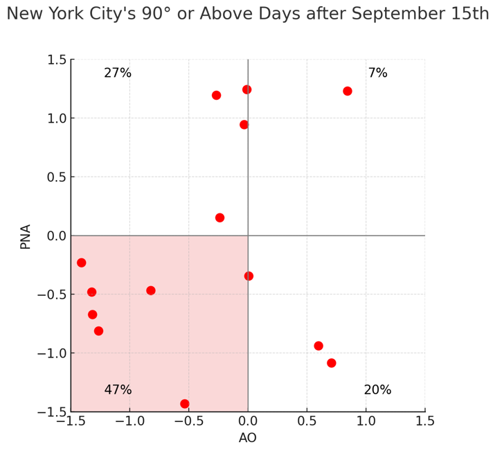
-
One possibility (not proven AFAIK) is that the recent unusually deep E US upper trough pattern correlates somewhat with relatively inactive Atlantic. If so, it seems to me that that would likely be a significant contributing factor. Unfortunately though, that extra level of protection may not carry over to the late season climo favored W Caribbean centered area of genesis, which for US threat potential starts to dominate next week. What’s got me a little worried is: -the last 2 days of Euro Weeklies have 120-150% of the active 2005-24 avg ACE starting next wk for 3 wks, which adds to ~42 ACE 9/22-10/12 -The good news is that a large portion of the 9/22-28 ACE is being generated by the current MDR AOI, which appears based on great op/ens agreement to be an easy safe recurver from us -But there’s some activity during that week in W Car/Gulf -Though some of the 9/29-10/12 activity is well out in the Atlantic and thus not threatening, the W Car/Gulf activity level is even higher for 9/29-10/12 vs that of 9/22-28, which is consistent with peak climo for that region -I sincerely hope this relative “dud” of a season continues, especially after the overall high impact to the SE US (including 5 storms with significant impact to my area!) and Gulf during 2016-24. We are so overdue for a break. But with relatively dangerous ENSO on avg (weak La Niña), with late seasons recently being bad, and with what the most recent EWs have shown, the Conus will need good luck to get out of 2025 unscathed. *Edit: Actually, the US won’t get out unscathed as both TS Chantal and H Erin significantly affected parts of the Carolinas.
-
I’ll try to stop bitching this wx has been nice lol I’m being a big baby right now

-
There's a strangeness about the local hemisphere ( along 30 N from west of California, east to the Sargasso Sea/N. Atl Basin ) where the ridges are perforated by all these pinch mid/u/a/ lows and/or TUTTs and such. That circumstance hugely limits the likeliness than any MDR TC would firstly be able to survive the increased shear quotient in the means. Also, another likeliness killer is that steering fields are not west-->east along extended distances because these punched holes in the ridge offer too many more opportunities that encourage capture into early retirements. (hint, I know why that overall circumstance is happening, but the CC explanation rubs those that swear by not denying while denying any evidence that connecs to CC ... CC is real so long as it doesn't interfere with the prospect of d-drip potency, huh )
-
Glad to hear it! Where did you go if I may ask?
-
The models are trending up with rain over the next couple weeks. Some runs are showing a series of slow-moving lows moving across the upper midwest.
-
If we finish this season below 100 ACE I for one will not be the least bit surprised
-

Central PA Summer 2025
Mount Joy Snowman replied to Voyager's topic in Upstate New York/Pennsylvania
Low of 60. Back from the beach. Kids had an awesome time and the weather was perfect. No rain in the bucket here.


.thumb.png.4150b06c63a21f61052e47a612bf1818.png)


