All Activity
- Past hour
-
Can someone post the 0z eps? I didn’t see it in the thread. With comparison to 12z would be appreciated. Thanks! .
-
A nice chilly 12.0/-0.7 with clear skies at 7 am here. Wind W at 7 gusting to 13 mph making WC 1 to -3. Low was 11.9 degrees at 6:25 am. I see Canaan NWR is a crisp -1 this morning.
-

January 25/26 Jimbo Back Surgery Storm
NorthHillsWx replied to Jimbo!'s topic in Southeastern States
Agreed. This is the rare event where, with 2+” of QPF possible some areas could mix for over half the storm and still end up with a foot of frozen. This isn’t wasting half our 0.30” in mix like we’ve become accustomed to… -

January 2026 regional war/obs/disco thread
jbenedet replied to Baroclinic Zone's topic in New England
The surface high is intensifying over our heads on guidance. I’d call it Canadian but it’s over our head throughout. Filling in for Quebec.. Great news for our southern neighbors who love snow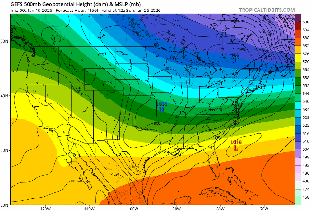
-
Already working on it
-
 I think the mesos will continue to be useful for some time.
 -

Possible Record Breaking Cold + Snow 1/25 - 1/26
psv88 replied to TriPol's topic in New York City Metro
18”, Southern side of Commack NY -

Possible Record Breaking Cold + Snow 1/25 - 1/26
sussexcountyobs replied to TriPol's topic in New York City Metro
27.5" thus far in Vernon Twsp. @ Canistear Reservoir -
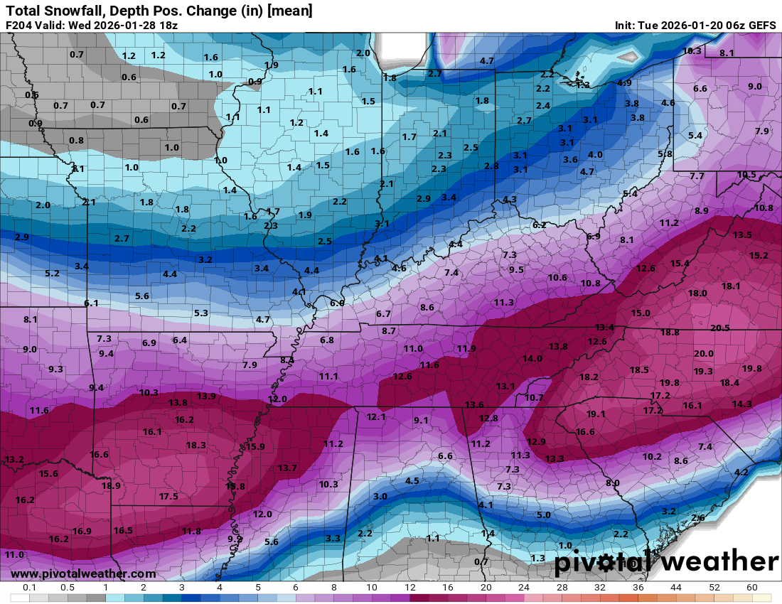
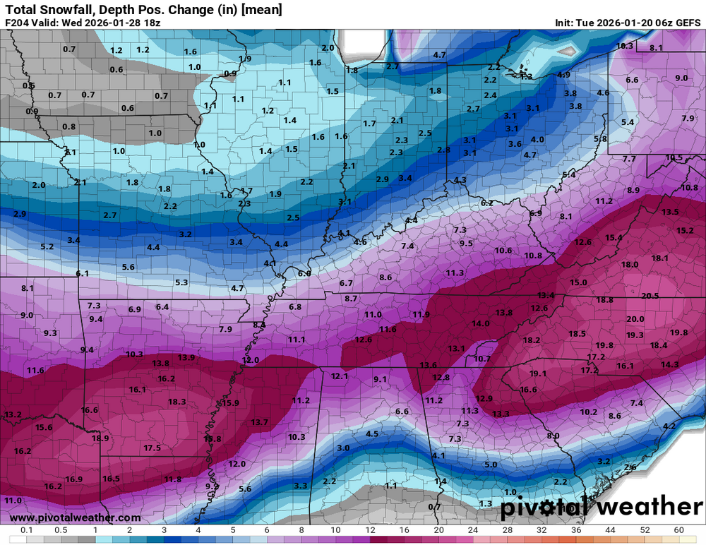
Latest blend. I think we got us a solid signal across guidance for a major winter storm lol
-
It certainly is concerning, especially for anyone who gets ZR, with near record cold behind it. Thankfully snow shouldn't be wet and sleet is not really a concern from a power outage standpoint. I do anticipate a good deal of confusion from the general public on this point because the thinking goes: sleet is ice an ice causes power outages?
-
January 2026 regional war/obs/disco thread
Go Kart Mozart replied to Baroclinic Zone's topic in New England
Exactly 4" more than Methuen. -

January 25/26 Jimbo Back Surgery Storm
snowbird1230 replied to Jimbo!'s topic in Southeastern States
Bump -
We'll both be flirting with 0 tonight.
-
Who will be the first to start warning everyone to be cautious and pointing out possible red flags? Odds favor Ralph but Heisy has been known to piss in the cheerios...Chuck is probably good to point out the pattern breaking down during the snow. That osfan dude can be pretty negative in the midst of a potential storm. Im going with Heisy as my best bet
-
NWB
-
I guess the next time the European shows a 4 foot snowstorm at hour 360 we should probably take it seriously
-
January 25/26 Jimbo Back Surgery Storm
NorthHillsWx replied to Jimbo!'s topic in Southeastern States
I hope people realize how rare/epic 4-6” of sleet would be -
That was my low, 8 now.
-

January 2026 regional war/obs/disco thread
Kitz Craver replied to Baroclinic Zone's topic in New England
Hey you said it… -
My amateur gut is telling me a system that continues to strengthen as modeled always ends up bringing the warmth with it causing all but the border counties in NC to mix, historically speaking. The problem is, as modeled, most of the NC forum sees 12+ before we would switch to several inches of sleet should that happen. 2"qpf?!? Ugh. I know one of you in here quietly wished for this and now it appears we're going to deal with it. Bueller? Bueller? Historic and catostrophic are not significant enough words given the broad swipe of winter that is about to happen. (Throughout the TN valley and MA too!)
-
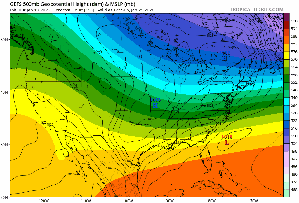
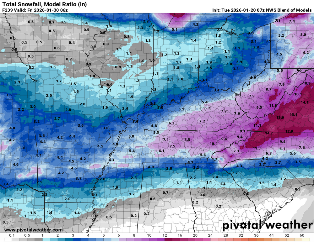
6z gefs
-
-

January 2026 regional war/obs/disco thread
40/70 Benchmark replied to Baroclinic Zone's topic in New England
Well, Amwx is an inclusive, judgement free zone. -
Clear. +7.7F
-

January 2026 regional war/obs/disco thread
dendrite replied to Baroclinic Zone's topic in New England
That euro suite is definitely intriguing…a lot more ridging in the northeast.