
All Activity
- Past hour
-

Augdewst 2026: Summer's Last Stand
OldSkool replied to Prismshine Productions's topic in New England
Tappan Zee bridge changed to Governor Mario Cuomo Bridge. -

E PA/NJ/DE Summer 2026 Obs/Discussion
Ralph Wiggum replied to PhiEaglesfan712's topic in Philadelphia Region
-

Occasional Thoughts on Climate Change
Typhoon Tip replied to donsutherland1's topic in Climate Change
There's no debate. The objective reality is that this was caused by destabilization of geological mass (ice/rock/water) failing and thus accelerating from elevation. The +flux (which means increase) of melt water destabilizes the previous the geologic structural integrity that previously held glacial lake and unstable landscapes at bay. A collapse was inevitable. Occurring at significant elevation provided excessive momentum - a structural failure that went on to become mass-gaining. The land, ice, or both-slide probably inundated glacial lake, en masse accelerating down the highly sloped region... subsequently gaining more most every time in swept through and acquired the mass of any alpine lakes and kettle nadirs that may have been transiently filled with seasonal melt ...etc etc... now you have a biblical torrent with so much mass/weight, it is capable of setting of seismology detection. That's it as far as cause. The rest is humanity building civility in the fertile/convenience of an alpine river valley thus being in the way when that happened. -
FWIW, the GFS this morning redevelops Dolly's remnants in the GOM and gives Texas a hurricane. Yeah should be interesting if/when it opens back into a wave, will NHC immediately put an orange/red back onto the TWO.
-
True about the models, but I don’t think that was a real can kick. If October is abnormally dry though, I’ll concede
-
I could get behind the petition to rename Canadian geese as Donald ducks.
-
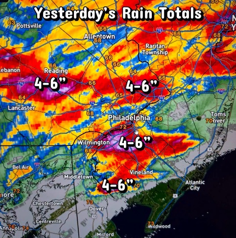
Great pic! I'd send one, but it would have just been of the cloud deck and rain. Picked up 1.49" with LOTS of T&L between 10 pm and 1 am. Sitting at 5.28" for the month.
-
Why is it every time the models show a wet pattern coming up it collapses a week before it starts? Will the niño ever kick in? Or is this nw dominated pattern the new normal?
-
Punting from September to October. There were signs that September was going to turn wet but over the course of this week the modeling for it completely collapsed.
-
Looks like a general 1.75-2.25 inches of rain IMBY last night based on the NWS data.
-
Augdewst 2026: Summer's Last Stand
Typhoon Tip replied to Prismshine Productions's topic in New England
Wouldn't shock me if ensuing administration applies referendums, if not immediately repeals when and where legislative rules allow, many of the changes that have been making headlines during this ... quirk of history BS that seems like an infinitely long 4 years in an asylum run by inmates -
I think the easiest answer is the marine heat wave off japan. +5-8c anoms are going to have an effect there. But once the NH cools, that will get chipped away slowly but surely. Like it did the last couple of years, it may take a few months but we have time
-
It has been two weeks since our last rain. We could use a soaker.
-
Oh are we really doing this? Ok, let’s split hairs. In another post, I said Sept-Nov is when we should see effects. So what is “mid-fall”? Fall is SON, Winter is DJF. In the middle of SON is October. Where’s the can kick?
-

2026-2027 Record-breaking El Nino
40/70 Benchmark replied to Stormchaserchuck1's topic in Weather Forecasting and Discussion
Right...weakening correlation due to the the ambient warmth washing it out, which is why it's facing more hemispheric competion. -
2026-2027 Record-breaking El Nino
40/70 Benchmark replied to Stormchaserchuck1's topic in Weather Forecasting and Discussion
Like I just said, competing forces....it's why 2023 had MC tendencies. Last season wasn't as favorable as 1995....you keep acting as though CC was the only difference. It wasn't. -

Central PA Summer 2026 Discussion/Obs Thread
mahantango#1 replied to Voyager's topic in Upstate New York/Pennsylvania
-- Changed Discussion -- 1) Late summer warmth to end August and start September with potential severe weather and heavy rain threats early next week -- End Changed Discussion -- && .DISCUSSION... -- Changed Discussion -- IR satellite trends show fog coverage expanding in the western and central valleys where skies have cleared for the most part. Can`t rule out a stray shower/t-storm southeast of I-81 today, but overall conditions will be trending drier/less humid through Saturday. Noticeable cooler tonight with more locally dense valley fog into early Saturday morning. -------------------------------------------------------------- KEY MESSAGE 1: Late summer warmth to end August and start September with potential bouts of severe weather and heavy rain early next week Large scale pattern to close out August and kickoff September will feature an expansive sprawling upper ridge centered from the southern Plains into the Southeast U.S. Residing on the northeastern periphery of the upper high in CPA will open the door for returning late summer heat/humidity along with the potential for episodic bouts of severe weather/heavy rain in a ring of fire type pattern. WPC has introduced a marginal risk of excessive rain Monday 8/31 and Tuesday 9/1 across northern PA. This limited predictability flow regime offers reduced confidence in the precip department, but does send a strong warm signal for temperatures trending above the historical average as the 9th month of 2026 gets underway. -- End Changed Discussion -- -

-
FWIW, the GFS this morning redevelops Dolly's remnants in the GOM and gives Texas a hurricane.
-

Augdewst 2026: Summer's Last Stand
weatherwiz replied to Prismshine Productions's topic in New England
LFG.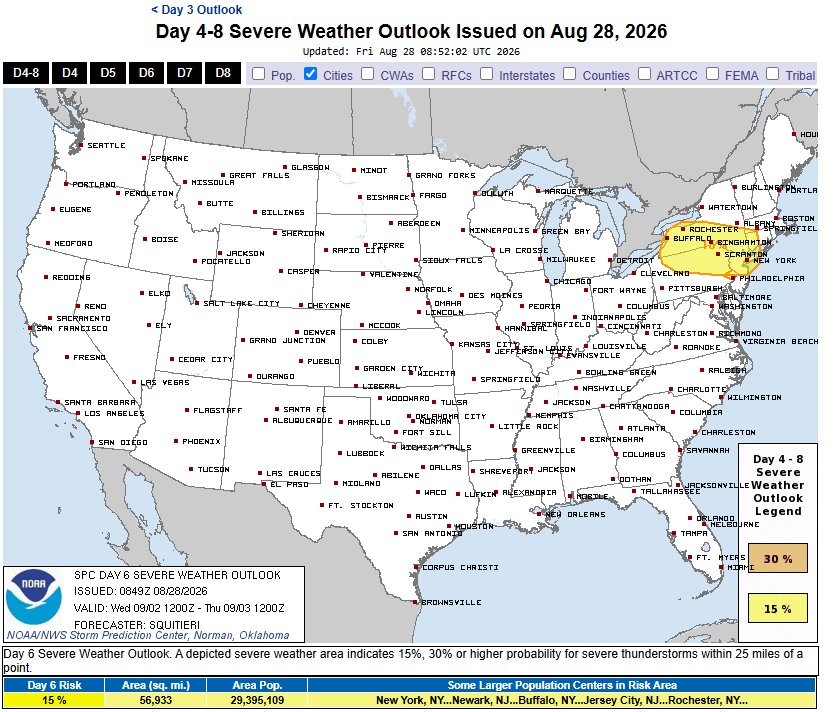
-
Was EasternUSWX renamed to American weather to distract from the winter of 2009? Just a thought...
-
Looks like the government deregulated the transgenic american chestnut. I initially supported the original Darling 58 trees, but the whole thing became a fiasco with a mix up. These are Darling 54 trees now and they don’t have the vigor the D58 or regular trees had. https://www.aphis.usda.gov/news/program-update/usda-deregulates-american-chestnut-engineered-enhanced-blight-tolerance
-

2026-2027 Record-breaking El Nino
GaWx replied to Stormchaserchuck1's topic in Weather Forecasting and Discussion
According to the following link, NOAA has switched to RONI as its official way of reporting ENSO effective 2/1/2026 and not just for weak ENSO despite them still maintaining the ONI dataset: https://www.cpc.ncep.noaa.gov/products/analysis_monitoring/ensostuff/ONI_v5.php -
 Check this out: [url=https://www.medguideusa.com/guide/lasix/]MedGuide USA[/url] to avoid side effects.
 -

2026-2027 Record-breaking El Nino
bluewave replied to Stormchaserchuck1's topic in Weather Forecasting and Discussion
You are talking local patterns and nuances more than the actual strength of the event. The last event in 2023-2024 jumped the planet to a new higher global temperature baseline with a relatively weaker RONI. The Nino ridge was among the strongest on record with the warmest winter in record for the CONUS and much of North America. It’s debatable whether the weaker Aleutian low was a function of RONI or just a symptom of weaker upper lows in general over the years with both La Ninas and El Niños. Notice this past winter with a weak La Niña configuration closest to 1995-1996 the ridge overpowered the pattern with smaller 500 mb lows.














