All Activity
- Past hour
-
at least dry air shouldn't be an issue with this one.
-
I have my 1-3" pants on.
-

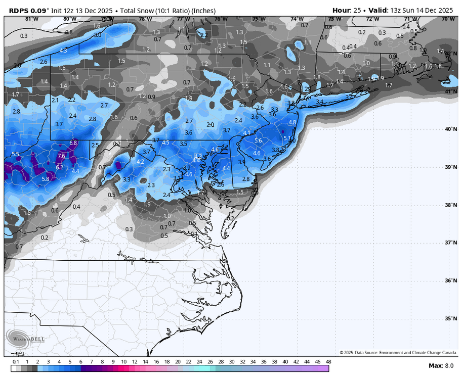
Moderate snowfall 12/14/2025 WWA up for most of the area
jm1220 replied to WeatherGeek2025's topic in New York City Metro
I definitely see the chance for a northern weenie band somewhere, hopefully it doesn't park over the sound. That's where the mid level lift and fronto would be best and could sneak a 5-6" total. North of that unfortunately might be skunked somewhat with subsidence but we have to see how it evolves. Also liking how the snow seems to linger longer which might be based on the trough bending a little more and bringing more moisture north, so it might be more like a 12 hour event from maybe 3z to 15z around or east of the city. The sound might help enhance the snow as well over LI since we have a northerly flow with the storm-the northerly winds enhance lift through frictional convergence-the wind "piles up" over LI and forces air to rise. Should be a nice little event. Not huge by any means but on the upper end of what this kind of fast pattern allows. I could see a 6" total or two where the banding sits overhead and if the snow lingers for 12 hours or more. -
Risking more banter, I too am old enough to have OBSESSIVELY called 936-1212
-
 Yes true in all areas except near the Belvedere Castle/CPK weather station
 -

Central PA Winter 25/26 Discussion and Obs
pasnownut replied to MAG5035's topic in Upstate New York/Pennsylvania
as been of concern for the last few days, the coastal interaction is easters key to the snow globe toy chest. Prorgressive pattern keeps this thing moving, and still worries me that any delay, will quickly rob wester LSV folks, and even me as. Somethin to keep an eye on. While not a Miller B, similar attributes/characteristics in play IMO -
I also remember that my dad had a radio that could pick up NOAA Weather Radio stations, kinda dull way back in my youth but for its time it was pretty cool.
-

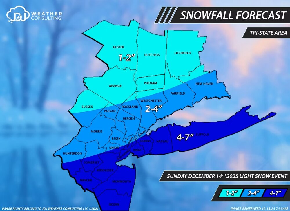
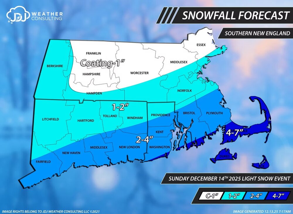
December 14th - Snow showers or Plowable snow?
ORH_wxman replied to Sey-Mour Snow's topic in New England
NAM has some really good snow growth on the south coast predawn and early morning tomorrow. So if they can get into some decent rates, they could fluff their way to low end warning. -
That thing is the Lucy of CAMs. Always the warmest, driest model it seems.
-
Yep, and no area code before it.
-

Saturday night/Sunday 12/13-12/14 Jawn
The Iceman replied to Ralph Wiggum's topic in Philadelphia Region
2-4” with lollipops of 6” seems like a safe bet at this point -

December 14th - Snow showers or Plowable snow?
TauntonBlizzard2013 replied to Sey-Mour Snow's topic in New England
I’m going to make a map once the rest of the 12z suite comes out -
Central PA Winter 25/26 Discussion and Obs
pasnownut replied to MAG5035's topic in Upstate New York/Pennsylvania
get a room. -
Thanks Don. I would imagine Boston must have a similar steak as the snow hole has basically been Philly to Boston.
-

Moderate snowfall 12/14/2025 WWA up for most of the area
Rmine1 replied to WeatherGeek2025's topic in New York City Metro
What’s different about this storm than what we have seen in the recent past, is that the preceding air masses have been cold. The ground is ample cold, so snow should accumulate very quickly. -
Central PA Winter 25/26 Discussion and Obs
pasnownut replied to MAG5035's topic in Upstate New York/Pennsylvania
Yours smarter than us (well me anyways) so keep talkin, cause were listening. -
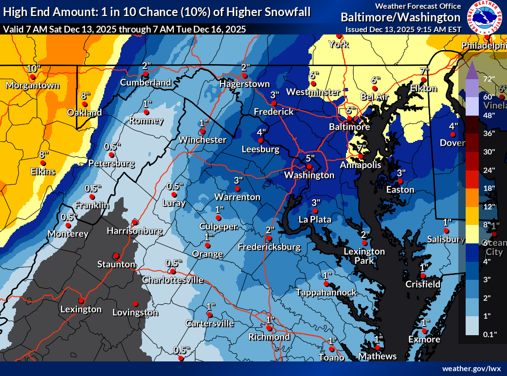
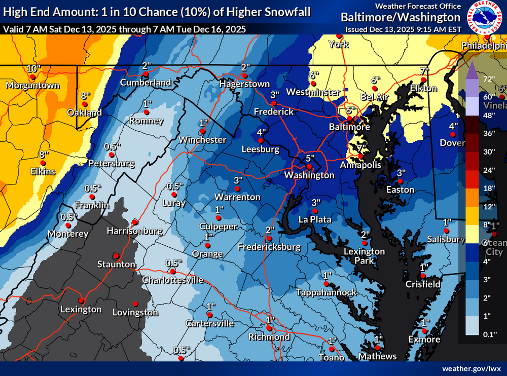
latest NWS high-end map, probably not going to verify but we can dream, right?
-
WE-6-1212. (Age-related): Don’t forget about A.M. Weather on TV.
-
Yeah, that’s always up to debate. For me I found a spot in the yard for my snow stake that is out from under the trees and is a good indicator of when I get down to 50% coverage or less. So when there’s nothing at my stake I just call it patchy snow cover. Case in point, 2.5” at the stake this morning but I have bare spots under trees.
-
936-1212 lol. The ink was worn off the buttons on our kitchen phone hahaha. When snow was in the forecast I would burn it up late afternoon waiting for the update. Great memories that few can relate to outside of this forum. I'm pullin for you folks up north. It's a tricky setup but I really hope it comes through and swipes the metros with a satisfying snowfall. Nature's Xanax and things like that
-

December 14th - Snow showers or Plowable snow?
Ginx snewx replied to Sey-Mour Snow's topic in New England
ACK MVY should see WSWarnings today -

12/14: Sunday funday? Will the south win again?
NorthArlington101 replied to TSSN+'s topic in Mid Atlantic
-

December 14th - Snow showers or Plowable snow?
Sey-Mour Snow replied to Sey-Mour Snow's topic in New England
Conservative final call, may be nudged north 5-15 miles tonight if mesos beef up. I wouldn’t be surprised in 5-7” amounts along the immediate south coast if that fronto band clips there. With .25-.45” qpf model blend in southern CT 2-4” should be easily attainable and if we can get those ratios to :15:1 there will be some surprises.
-
Loved seeing the small flakes on/off yesterday as I did some shopping. Low of 27 at 6:44am. Hoping for 60 today.
-
December 14th - Snow showers or Plowable snow?
Ginx snewx replied to Sey-Mour Snow's topic in New England
Trending slower further Northwest. Nice