All Activity
- Past hour
-

Central PA Winter 25/26 Discussion and Obs
pawatch replied to MAG5035's topic in Upstate New York/Pennsylvania
18 degrees this morning. Liked it better in the 30’s Looks like I might get 1-2” of snow tonight…Haven’t checked yet this morning. And you’re going to get some snow Thursday and looks like that’s staying south of me. The ground is still covered with snow this morning. -
26.8 this morning, last 20s of the month
-

Central PA Winter 25/26 Discussion and Obs
philliesmd replied to MAG5035's topic in Upstate New York/Pennsylvania
They got pretty close. RECORD EVENT REPORT NATIONAL WEATHER SERVICE BOSTON/NORTON MA 0131 AM EST TUE FEB 24 2026 ...RECORD SNOWSTORM FOR PROVIDENCE RI... THE BLIZZARD OF 2026 BROKE SEVERAL SNOWFALL RECORDS AT RHODE ISLAND T.F. GREEN INTERNATIONAL AIRPORT IN PROVIDENCE: - STORM TOTAL SNOWFALL OF 37.9 INCHES BROKE THE RECORD FOR THE GREATEST SINGLE SNOWSTORM ON RECORD, WHICH WAS 28.6 INCHES SET DURING THE BLIZZARD OF `78, ON FEBRUARY 6-7, 1978. - DAILY SNOWFALL OF 35.5 INCHES BROKE THE RECORD ONE-DAY SNOWFALL, WHICH WAS 19.0 INCHES SET DURING THE BLIZZARD OF `96, ON JANUARY 8, 1996. - FINALLY, THE DAILY SNOWFALL OF 35.5 INCHES BROKE THE RECORD SNOWFALL FOR FEBRUARY 23, WHICH WAS JUST 3.8 INCHES IN 1967. -

Pittsburgh/Western PA WINTER ‘25/‘26
Rd9108 replied to Burghblizz's topic in Upstate New York/Pennsylvania
It appears a pretty decent band went through overnight. Everything is covered and looks like maybe another inch outside. Another 1-2 tonight-wednesday and then who knows about the weekend. Its funny how just two weeks ago it looked like winter was dead. -
Bob on WVIT took out anything for Thursday night/ Friday. He said there was some agreement with the medium range models showing everything being pushed out South, but he's not writing it off. That storm next Wednesday looks like it could be another potential snowstorm
-
17" NW part of Southbury....
-
Yeah, the GFS was #1 back to last weekend with the longer range forecasts and the AIFS was #2. In the shorter range it was the SPC HREF that did the best. For consistency across the entire season the best scoring models have been the AIFS and EPS AIFS. So it’s good to see the AIFS not having the suppression bias of the OP Euro and EPS with East Coast storms.
-
@The 4 Seasons15.3 inches from this storm. 59.3 on the season. Highland Mills Orange County NY. between NNJ, LI, RI and SEMass I imagine you've got your hands full. Lots of 30+ out there.
-
Think it might be the only one that has it?
-

2025-2026 Fall/Winter Mountain Thread
Buckethead replied to Buckethead's topic in Southeastern States
7° with clear skies this morning. Picked up another inch overnight to bring my total to 10.75". That brings my season total to 65.25" making this my snowiest season here in Wolf going back to 2017. Sent from my Pixel 10 Pro using Tapatalk -

E PA/NJ/DE Winter 2025-26 Obs/Discussion
PhiEaglesfan712 replied to LVblizzard's topic in Philadelphia Region
The March 2-3 event now looks more like a cold shot, than a precipitation event. -

Central PA Winter 25/26 Discussion and Obs
Mount Joy Snowman replied to MAG5035's topic in Upstate New York/Pennsylvania
Edit: I was going strictly off of Blizz’s post about 0z when I said that, but after checking some other guidance and the 6z gfs/nam it appears things are now projected well south of us. Who knows ha. -

"Don’t do it" 2026 Blizzard obs, updates and pictures.
Baroclinic Zone replied to Ginx snewx's topic in New England
-
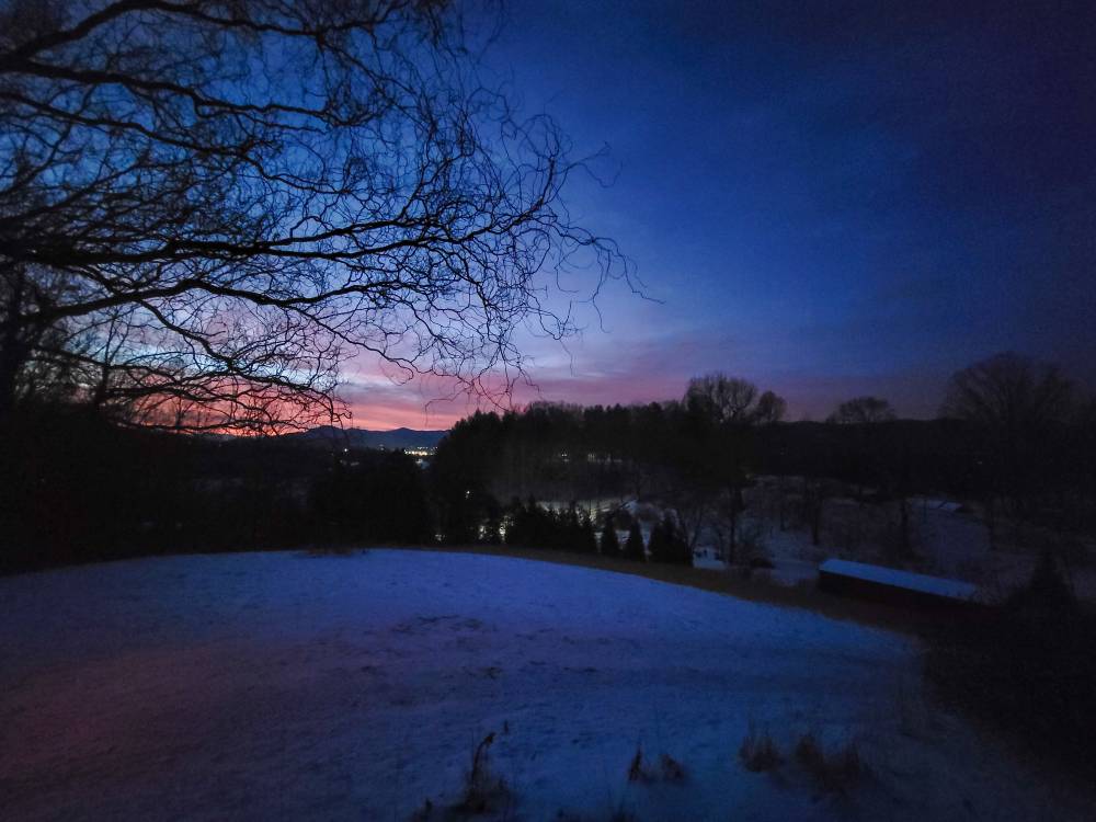
Beautiful sunrise this morning. Sent from my SM-G998U using Tapatalk
-
"Don’t do it" 2026 Blizzard obs, updates and pictures.
Baroclinic Zone replied to Ginx snewx's topic in New England
National Grid with and additional 23k -
@The 4 Seasonsnot sure where you are collecting totals so I’ll try here, 5.5” total, 44.5” season total.
-
Im assuming all models are south/suppressed for Thu/Fri?
-

"Don’t do it" 2026 Blizzard obs, updates and pictures.
wx_observer replied to Ginx snewx's topic in New England
And this was with Cat 1 winds and without fully leafed trees. Not that it can get much worse for the Cape itself...but makes you wonder how further inland might fare in a Cat 2 hurricane when the trees are fully leafed out. -
Ironically friends I have in lower Stony Brook off 347 got 26 inches, while 2 miles north by rt 25 got 19. Crazy. I remember the storm in 2013 I think it was, rt347 was the jackpot zone with 33 to 37 inches while 2 miles in either direction had more than a foot less.
-

Guess The Date Of The Next 12"+ Snowstorm In The OKX Zones
bluewave replied to bluewave's topic in New York City Metro
2-22-26 to 2-23-26 Central Islip 31.0 in 0140 PM 02/23 Trained Spotter -

"Don’t do it" 2026 Blizzard obs, updates and pictures.
BrianW replied to Ginx snewx's topic in New England
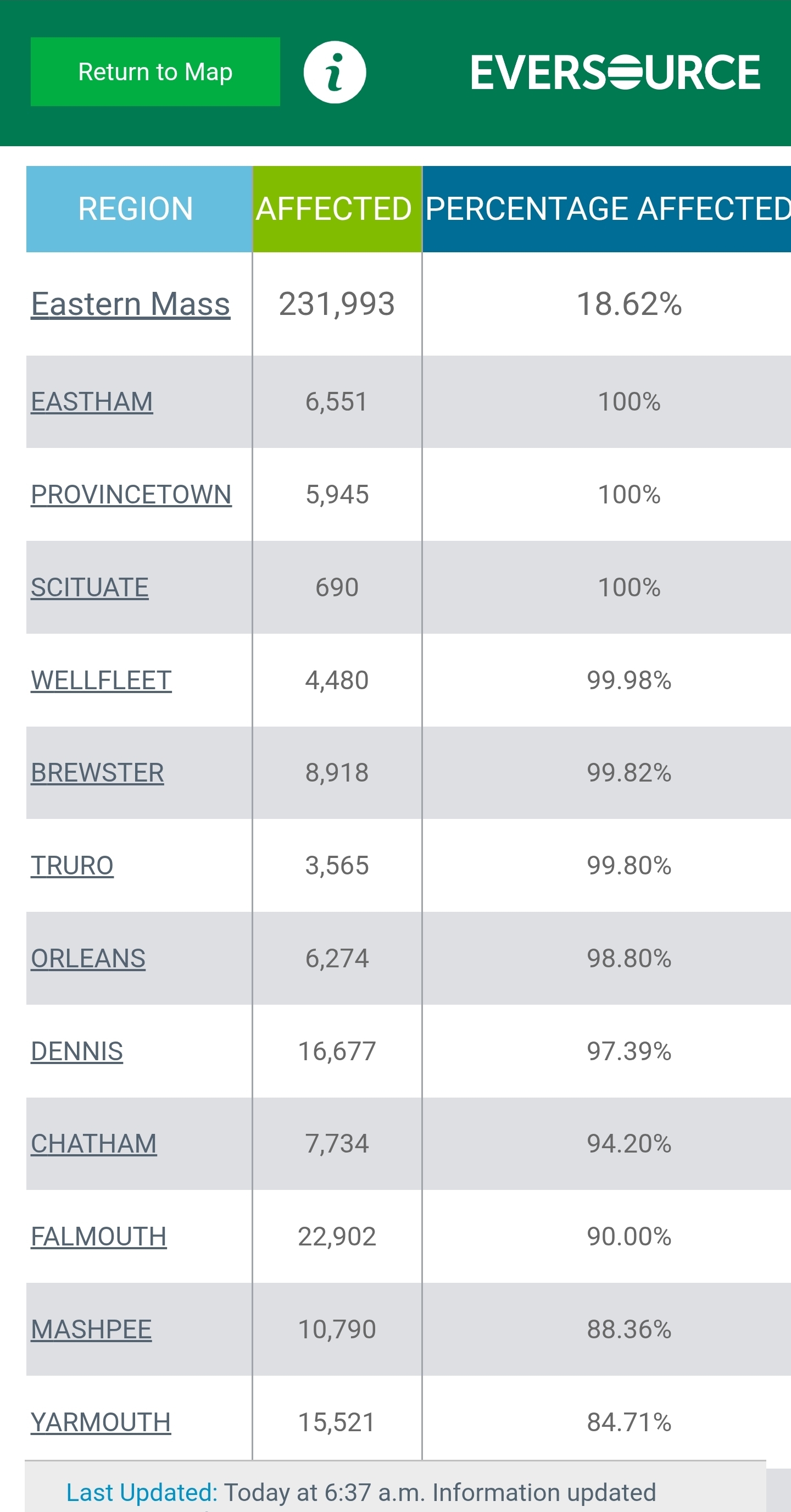
Still 230k outages in Eastern Massachusetts. Look at those outages on the cape. Total grid failure. Surprisingly Eversource in CT is only reporting 600 outages.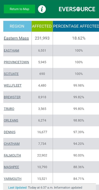
-
"Don’t do it" 2026 Blizzard obs, updates and pictures.
wx_observer replied to Ginx snewx's topic in New England
Historic, indeed. https://www.wcvb.com/article/blizzard-prompts-boston-globe-management-to-call-off-printing-paper-for-first-time-in-153-years/70475083 -
Yes, this totally lol. I am like, what's next?
-

"Don’t do it" 2026 Blizzard obs, updates and pictures.
Chrisrotary12 replied to Ginx snewx's topic in New England
I was starting to doubt the 5” I measured since everyone around was a bit higher But i see a trained spotter 1 WSW in Nashua reported 5.8”. Only 9-10” off the forecast. Hehe -
Central PA Winter 25/26 Discussion and Obs
Mount Joy Snowman replied to MAG5035's topic in Upstate New York/Pennsylvania
23 when I left the house. Perhaps a coating tonight and something a little more Thursday. Thursday would be tricky as a daytime event with marginal temps and a narrow swath of snow, but we might just be sitting in as good a spot as anyone. Much to shake out.