All Activity
- Past hour
-

Forecasting now vs. 30 years ago
Devidbrain replied to EWR757's topic in Weather Forecasting and Discussion
Forecasting has certainly evolved, with high-resolution models, ensemble forecasting, and AI greatly improving accuracy. NWS meteorologists can still rely on experience and local knowledge to adjust guidance, especially in complex or rapidly changing situations. While modern forecasts are more data-driven, expert judgment remains crucial, so some subjectivity and forecaster “personality” still play a role. -
Rhea?
-

2026-2027 El Nino
mitchnick replied to Stormchaserchuck1's topic in Weather Forecasting and Discussion
I'd roll the dice with that. -
Oof

-
Drought worsened significantly across the entire region on the latest drought monitor.
-
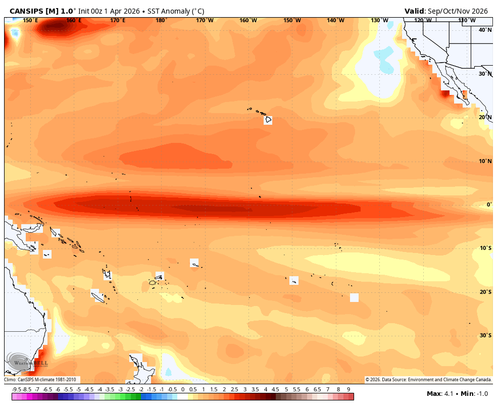
Cansips SON fwiw Modoki ~+2 in 3.4 (ONI), implying RONI ~~+1.5, with a peak ~+1.7 RONI in winter:

-
I still want to ski a couple more times... Not sure it will happen on the weekend of April 11/12, but I will try
-
2026-2027 El Nino
mitchnick replied to Stormchaserchuck1's topic in Weather Forecasting and Discussion
Not that anyone should care what I think, I'm stillnot seeing west anomalies prevailing over forecasts periods thru June. Gfs and Cfs are now both showing (I understand the relationship between the models) and easterly anomaly over the next week that has intensified over the past few days as reflected on the 2 attachments. That should knock 3.4 temps down a bit again. Again, I'm not saying a mod or strong Niño isn't possible, but more that the Niña continues to put up a decent fight..thumb.gif.599de0dd56cd4543ab238b95cef224c0.gif)
.thumb.png.efeba6d8451a24a5d1133be215435579.png)
-
Stuck in the nasty muck. What a difference a day makes today from yesterday and today to tomorrow. Hope we can get more sun tomorrow
-
Normally I’d wish that were happening here too…but not now. I’d rather have 65-70 with clouds and sun today. 41 with drizzle…
-

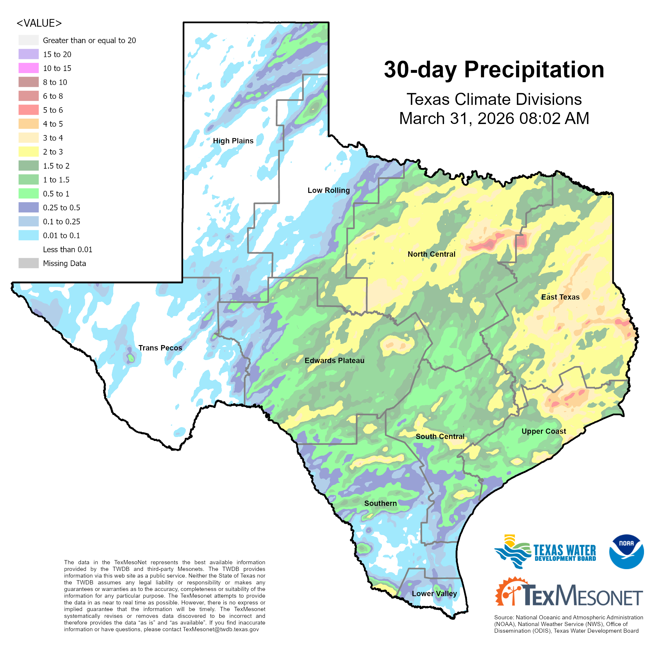
Texas 2026 Discussion/Observations
Stx_Thunder replied to Stx_Thunder's topic in Central/Western States
Not bad for March: Especially considering last year's March (2025) was sig drier with all the wildfires that also occurred. If we keep this up in April & May (likely a good bet now with ENSO transition back to EN territory finally underway), much of the ongoing statewide drought conditions should be taken care of at least till later summer. Things are already looking pretty wet (for the time of year) this Easter weekend with substantial MCS activity likely, and then again into mid-April.
-
They recently found out that was an error. https://journals.ametsoc.org/view/journals/bams/107/1/BAMS-D-24-0313.1.xml The world record hottest near-surface air temperature of 134°F recorded at Greenland Ranch, Death Valley, California on 10 July 1913 is demonstrated to be approximately 14°F hotter than what likely occurred on that date. Using July data from non–Death Valley stations during 1923–2024, we compute a range of temperature lapse rates diagnosed from the differences between Greenland Ranch station and the average of higher-elevation stations’ maximum temperatures (TMAX) and elevation. The range of lapse rates from those 102 years of July data is then used to estimate Greenland Ranch temperatures during the early years (1911–22). The first 2 weeks of July 1913 are shown to be spuriously hot and other years at Greenland Ranch exhibit anomalous July temperature behavior as well. Despite the establishment of a U.S. Weather Bureau instrumented shelter at Greenland Ranch in 1911, based upon historical accounts, we believe some of the shelter readings in the early years were replaced with hotter values, possibly taken from the veranda of the ranch house using a thermometer of unknown provenance. As a result of these findings, we recommend that the 134°F world record status be rescinded and that many of the Greenland Ranch temperature reports during the early years be more closely evaluated for data quality.
-
Snowing here
-
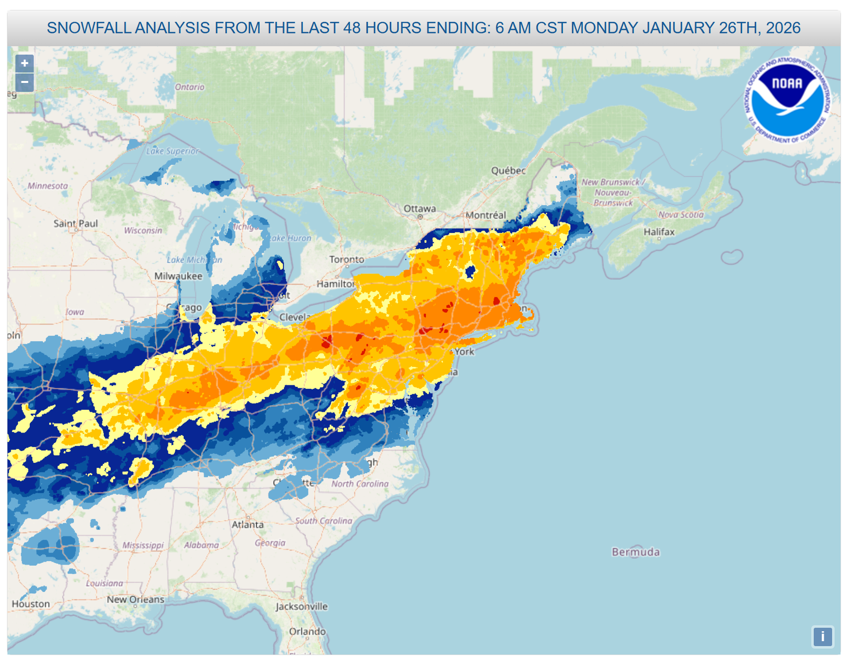
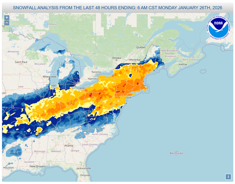
Are we ever going to get NESIS map for this event or are we just going to ignore it? It's obviously more than a cat 1 based on other storms in this list. Easily a 2 but most likely a 3. They were quick to do one for Feb 22-23 but just skipped this for some reason. https://www.ncei.noaa.gov/access/monitoring/rsi/nesis
-
April 2 2001: Jumbo-sized snowflakes fall in east central Minnesota and west central Wisconsin. 2.5 to 2.75 inch flakes measured in Maplewood. 1920: The temperature falls to 8 degrees in Pipestone. The high the day before was 74. For Thursday, April 2, 2026 1975 - The northeastern U.S. was in the grips of a severe storm which produced hurricane force winds along the coast, and two to three feet of snow in Maine and New Hampshire. Winds atop Mount Washington NH gusted to 140 mph. (David Ludlum) 1975 - The biggest snowstorm of record for so late in the season paralyzed Chicago, IL. Up to 20 inches of snow fell in extreme northeastern Illinois, and 10.9 inches of snow closed Chicago's O'Hare Airport. (The Weather Channel) 1982 - Severe thunderstorms spawned fifty-six tornadoes in the central U.S., including seventeen in the Red River Region of Texas and Oklahoma. The tornadoes claimed thirty lives, and injured 383 other persons. A violent tornado near Messer OK left only the carpet tack strips on the slab of a house it destroyed, and carried a motel sign thirty miles. (The Weather Channel) (Storm Data) 1987 - Eleven cities in Florida reported record low temperatures for the date, including Tallahassee with a reading of 31 degrees. The low of 48 degrees at Key West smashed their previous record for the date by 13 degrees. (The National Weather Summary) 1988 - Thunderstorms produced up to nine inches of rain around New Orleans LA causing 18 million dollars damage. A tornado caused three million dollars damage at Slidell LA. (Storm Data) (The National Weather Summary) 1989 - Strong and gusty winds prevailed from California to Colorado and Wyoming. Winds gusted to 50 mph at Lancaster CA, and reached 85 mph at Berthoud Pass CO. Snow and high winds created blizzard conditions in the Colorado Rockies. (The National Weather Summary) (Storm Data) 1990 - Thunderstorms produced severe weather in North Carolina and Virginia during the afternoon and evening. Thunderstorms produced golf ball size hail, and spawned a tornado near Chester VA which caused half a million dollars damage. A storm system produced snow and gale force winds across northern Michigan, with 8.3 inches of snow reported at Marquette. Temperatures in the north central U.S. soared from morning lows in the 20s and 30s to afternoon highs in the 60s and 70s. Eight cities reported record highs for the date, including Havre MT with a reading of 77 degrees. (The National Weather Summary) (Storm Data) 2005 - Heavy rainfall in the Northeast produced flooding in parts of New York, New Jersey and Pennsylvania. Severe flooding along the Delaware River forced the evacuation of 6,000 residents in New Jersey and over 5,700 in Pennsylvania during the weekend of the 2nd-3rd. Around 3,200 homes in New Jersey were damaged, while one fatality was reported in New York (Associated Press). 2006 - Tornadoes and hail as big as softballs ripped through eight Midwestern states, killing at least 27 people, injuring scores and destroying hundreds of homes. In Tennessee, tornadoes killed 23 people, including an infant and a family of four. Severe thunderstorms, many producing tornadoes, also struck parts of Iowa, Kentucky, Arkansas, Missouri, Ohio, Illinois and Indiana. Strong wind was blamed or at least three deaths in Missouri. The weather service's Storm Prediction Center in Norman, Okla., said it had preliminary reports of 63 tornadoes. The worst damage occurred throughout the Tennessee Valley. 2015 - Late night severe storms produced 80 to 100 mph straight-line winds that caused extensive damage from Hutchinson to Newton and Wichita. An 89 mph wind gust was reported at the Kansas Aviation Museum located in southeast Wichita. (NWS, Wichita, KS)
-
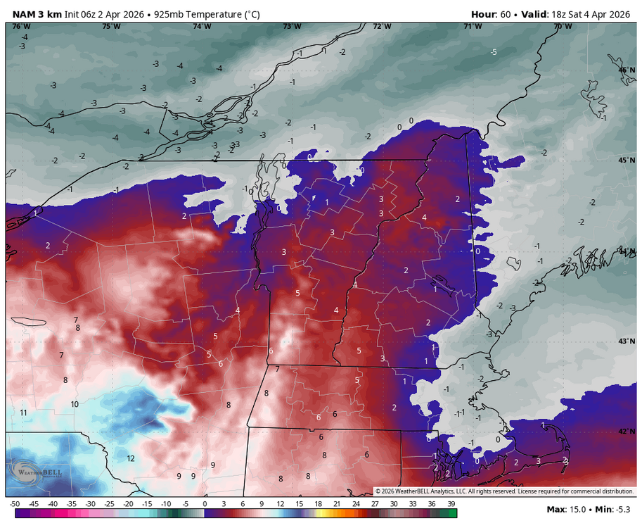
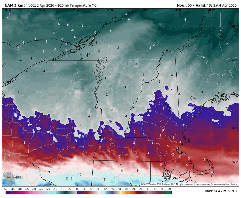
I saw that Saturday isn’t looking as good as before. 9am… 2pm…
- Today
-
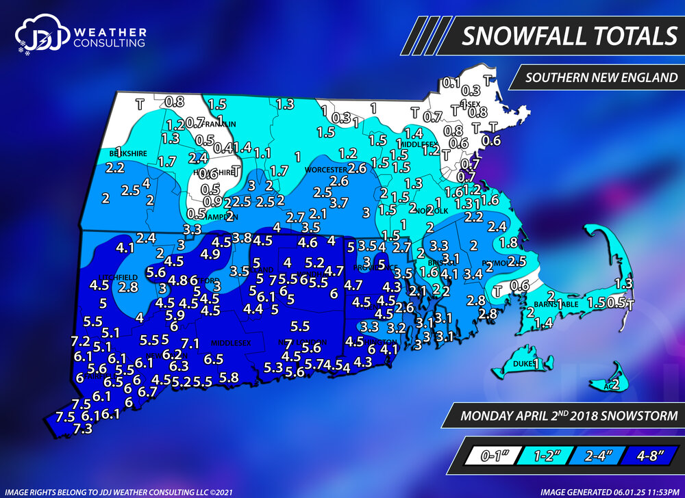
thanks for posting this 8 years ago today. The fifth and last snowstorm of the season. A low end warning event for most of CT and Tri-State after the 4 nor'easters of March 2018. https://www.jdjweatherconsulting.com/apr-2-2018

-
Breezy, 32 n no snow yet. A trace last night. Radar showing good returns coming in, but this is going to be a slop fest.
-
Nasty day here. Drizzle just ended but temps going nowhere
-
If that happens, and the heat dome is centered somewhere around Death Valley, the American/global temperature record of 134 degrees could finally fall.
-

2026-2027 El Nino
40/70 Benchmark replied to Stormchaserchuck1's topic in Weather Forecasting and Discussion
Right, but I think even the blizzard-zone would like to load the dice a bit more favorably with a somewhat weaker ENSO relative to that season. -
2015-2016 is acceptable
-
Early next week looks like dog poop
-
Switched over to light snow smaller flakes with some bigger ones mixed in!
-
They really need locusts...
- 78 replies
-
- 1
-

-
- april showers bring may..
- rain
- (and 2 more)


.gif.c1451bb7392c14b7a8396f3cb56c24c1.gif)
.png.df8c720da5ae033468bc0467962d9768.png)