All Activity
- Past hour
-

Hurricane Erin: 140 MPH - 937 mb - NW @ 10
wthrmn654 replied to BarryStantonGBP's topic in Tropical Headquarters
There is not much change to the track forecast reasoning, with the hurricane still expected to recurve over the western Atlantic between the U.S. east coast and Bermuda over the next 3-4 days. The main highlight of the new forecast is that much of the track guidance, including the consensus aids, have shifted slightly west of the previous NHC prediction during the first 2-3 days. The new NHC forecast is very close to the TVCA and HCCA consensus aids during the first 48 hours, and then closer to the TVCA aid beyond 48 hours. It should be noted that there is still some space for additional adjustments to the track forecast, particularly beyond 48 hours with the HCCA aid lying along the northwestern edge of the guidance envelope. -
-

Hurricane Erin: 140 MPH - 937 mb - NW @ 10
Kevin Reilly replied to BarryStantonGBP's topic in Tropical Headquarters
Totally agree looks like dry air and northerly shear taking its toll too. Erin does not look healthy at all on all satellite IR and water vapor. -
49.0° with some clouds…felt cooler yesterday. MVY 42° this morn
-
The weekend definitely had more potential for heat a few days ago. Erin is mucking it up a bit…especially in SNE. It’ll be warm up here, but nothing to write home about. COC has definitely won out this month. But with the abundant sunshine it’s been a beaut.
-
50 for the low...good stuff!
-

Central PA Summer 2025
Mount Joy Snowman replied to Voyager's topic in Upstate New York/Pennsylvania
Low of 62. Opening night of high school football on Friday looks absolutely perfect. -

Mid to long range discussion- 2025
WinstonSalemArlington replied to wncsnow's topic in Southeastern States
There is a significant change you will not reach 90 all August -
 Yeah, nice to see the Euro start showing a PRE since we really need it. But the placement of these features can be very fickle like IVTs in the winter. We can remember back in 2021 showing the PRE in SNJ and it would up in NYC. But at least there is now the potential for someone around the area to get some much needed rainfall even if later runs switch the location near the jet entrance region.
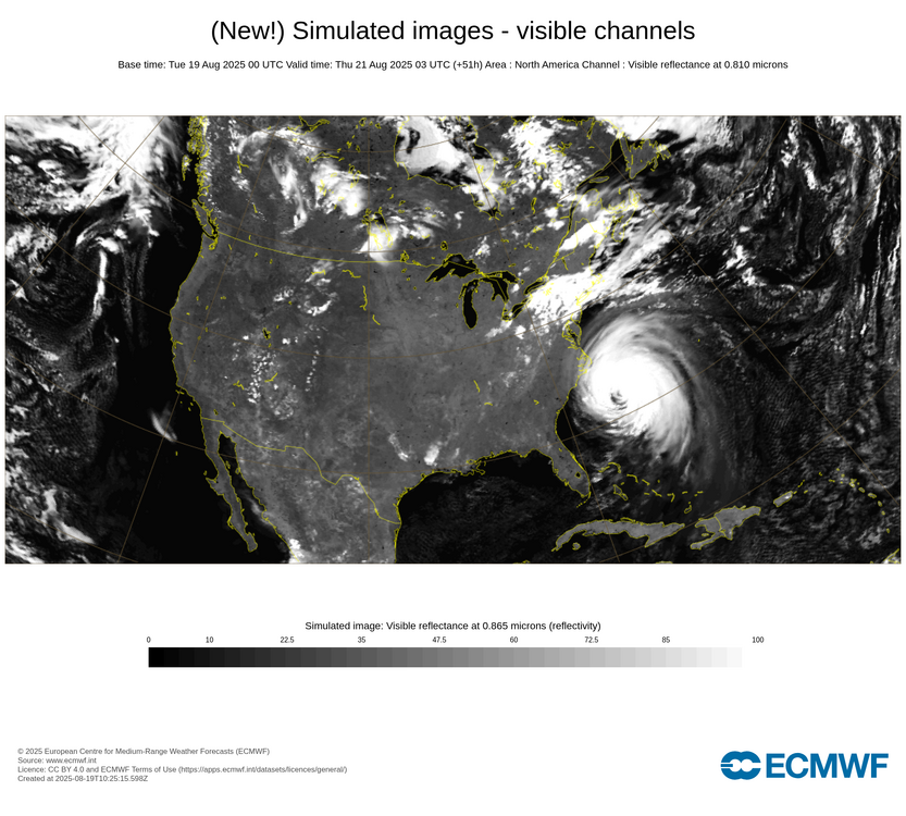
-
To add, the new 30 day QPF from the EPS is very dry for the mid-Atlantic and northeast. IF (if) correct, we will be in drought conditions again….
-
53/47 cool start. Boston with it's coldest anomaly of the month yesterday at -8.7. Maybe out do it today?
-
Down to 49F this am, and looks like rain on Wed looks to be CRV west with maybe .25 to the east. Crunch lawns here, need the rain!
-
No Nina’s are not a winter killer even south of New England
- Today
-

Hurricane Erin: 140 MPH - 937 mb - NW @ 10
Windspeed replied to BarryStantonGBP's topic in Tropical Headquarters
Erin is crawling right now. With its large circulation, upwelling is starting to become a real issue for it. Additionally, Erin is really helping to bring down SSTs east of the Bahamas. This should help keep anything down the road that traverses that region in check until SSTs can rebound somewhat in late August and early September. -

INVEST 99L FORMED: (30/30)
BarryStantonGBP replied to BarryStantonGBP's topic in Tropical Headquarters
Invest 99LAs of 06:00 UTC Aug 19, 2025: Location: 12.5°N 20.1°WMaximum Winds: 30 kt Gusts: N/AMinimum Central Pressure: 1010 mbEnvironmental Pressure: N/ARadius of Circulation: N/ARadius of Maximum wind: 30 nm oi lads reckon this might nick the name Fernand first or would this more likely be gabs -
INVEST 99L FORMED: (30/30)
BarryStantonGBP replied to BarryStantonGBP's topic in Tropical Headquarters
Why TF did the lemon nick 99L off the orange? -
This thread’s E MDR AOI (the current lemon, not the further west orange) is now Invest 99L:AL, 99, 2025081906, , BEST, 0, 125N, 201W, 30, 1010, DB, 34, NEQ, 0, 0, 0, 0, 1013, 120, 30, 0, 0, L, 0, , 0, 0, INVEST, S, 0, , 0, 0, 0, 0, genesis-num, 019, SPAWNINVEST, al792025 to al992025,
-

E PA/NJ/DE Summer 2025 Obs/Discussion
mattinpa replied to Hurricane Agnes's topic in Philadelphia Region
My ideal would be snow and cold for one season - then the rest of the year with temps like today, plenty of sun and just enough rain to not drought. -
Watching all the rain explode into nothing from the dry air after crossing the lake makes me sad, our farmers need it
-

NEW DISTURBANCE: Central Tropical Atlantic (10/60)
MJO812 replied to BarryStantonGBP's topic in Tropical Headquarters
Gfs is now offshore at 0z -

NEW DISTURBANCE: Central Tropical Atlantic (10/60)
GaWx replied to BarryStantonGBP's topic in Tropical Headquarters
Latest UKMET (0Z) still pretty weak and a little west of 12Z though still not far W of Bermuda: NEW TROPICAL CYCLONE FORECAST TO DEVELOP AFTER 102 HOURS FORECAST POSITION AT T+102 : 20.6N 64.4W LEAD CENTRAL MAXIMUM WIND VERIFYING TIME TIME POSITION PRESSURE (MB) SPEED (KNOTS) -------------- ---- -------- ------------- ------------- 1200UTC 23.08.2025 108 21.3N 65.7W 1010 28 0000UTC 24.08.2025 120 22.9N 67.2W 1011 30 1200UTC 24.08.2025 132 24.5N 68.2W 1011 35 0000UTC 25.08.2025 144 26.9N 68.9W 1011 35 1200UTC 25.08.2025 156 29.9N 68.4W 1012 35 0000UTC 26.08.2025 168 33.3N 67.2W 1011 31 -
Yes. The ops are just fantasy but the ensembles show a pattern that could be conducive. Everything is always low probability for here so there’s no need for folks to get riled up.
-

2025-2026 ENSO
Stormchaserchuck1 replied to 40/70 Benchmark's topic in Weather Forecasting and Discussion
^It seems the Euro ensembles are good at those long range forecasted hurricane numbers. I remember in the 2nd half of last season they had 5x average, and we sure did have an active period. -

Hurricane Erin: 140 MPH - 937 mb - NW @ 10
Wannabehippie replied to BarryStantonGBP's topic in Tropical Headquarters
11:00 PM EDT Mon Aug 18 Location: 24.4°N 71.7°W Moving: NW at 8 mph Min pressure: 949 mb Max sustained: 125 mph -
Just wanted to share this with you guys since the weather hasn't been all that active here except for the occasional storm. We do have a nasty hurricane out in the Atlantic, but it's going to mostly be a fish, with some wind impact on the east coast, but nothing here. Anyway, being the weather nerd that I've always been, even as a kid, I had a watch as a kid that had a thermometer in it. It was a Casio watch from the 80s. I loved that watch. I felt like I had a little weather station on my wrist. It was way ahead of it's time back then. Well, I found this baby on Ebay in great shape and for a pretty reasonable price. Works great. I feel like a kid again. Lol OK, back to weather talk. Lol Sent from my SM-S931U using Tapatalk


