All Activity
- Past hour
-
NYC was also very low with snow in 1950-1. Regardless, one season, alone, doesn’t destroy the theory because these correlations are not only not even close to 100%, they’re weak.
-

Hurricane Erin: 125 MPH - 940mb - WNW @ 14
nvck replied to BarryStantonGBP's topic in Tropical Headquarters
This is the OP from twitter, not sure how he made it. https://x.com/NickKrasz_Wx/status/1956730795533480017?t=KwNUUdLNnK9aEhPWPNV-7A&s=19 -
And like any relationship, it can always be overwhelmed by other factors working against it. I think @bluewave may have had the right idea that as teleconnections change with cc, potential connections like this become less reliable.
-
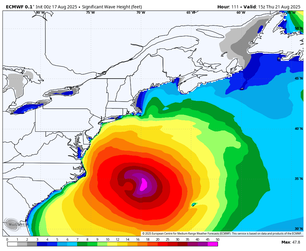
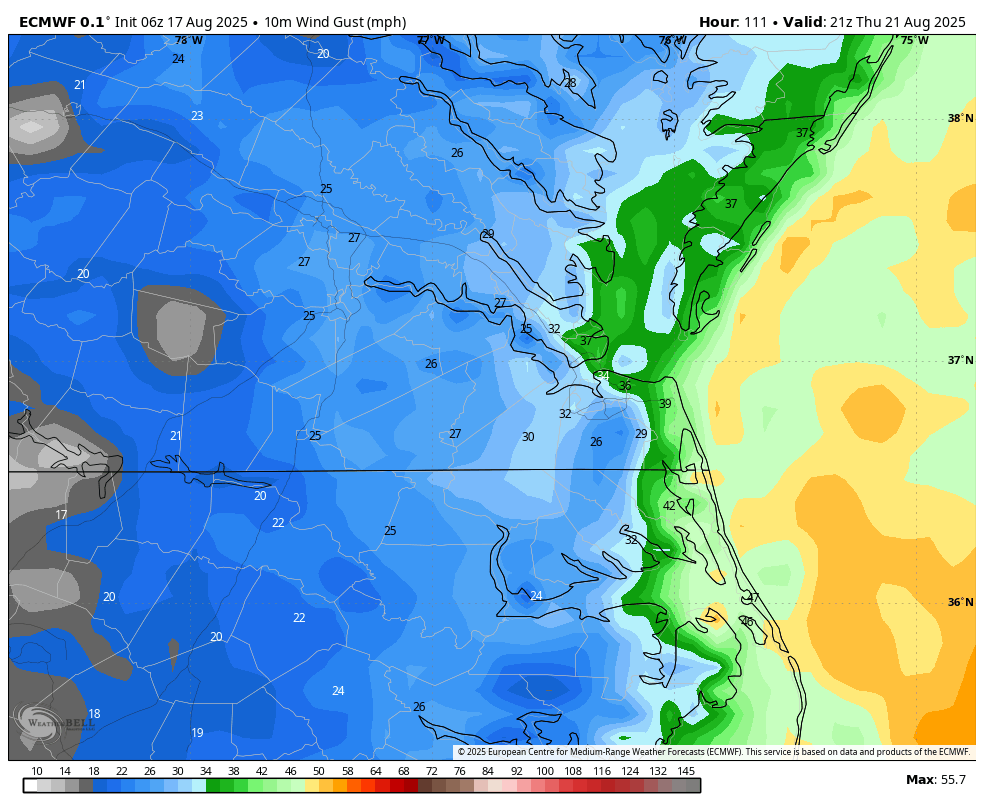
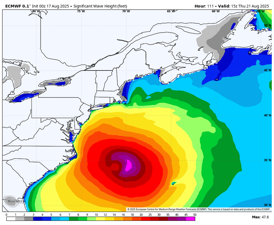
WB 0Z EURO wave and 6Z wind forecast gusts for Th.

-

Hurricane Erin: 125 MPH - 940mb - WNW @ 14
jconsor replied to BarryStantonGBP's topic in Tropical Headquarters
@bugalou These graphics of NHC cone/track overlaid with Erin satellite loop are very helpful. Did you create this via an app or website? I am familiar with WeatherNerds satellite loops that allow overlay of EPS/GEFS members. The CIMSS storm-specific page allows overlay of the *current* NHC track, but doesn't dynamically update it every 6 hours as your loop did: https://tropic.ssec.wisc.edu/real-time/storm.php?&basin=atlantic&sname=05L&invest=NO&zoom=4&img=1&vars=111110000000000000000000&loop=0&llval=OFF -
Worst climo trend continues. Man f*** West Michigan.
-
A much needed quality soak this morning, much of Champaign was 7” below normal rainfall for the summer.
-
ORH is SNE. Chestnut tree fall on head?
-
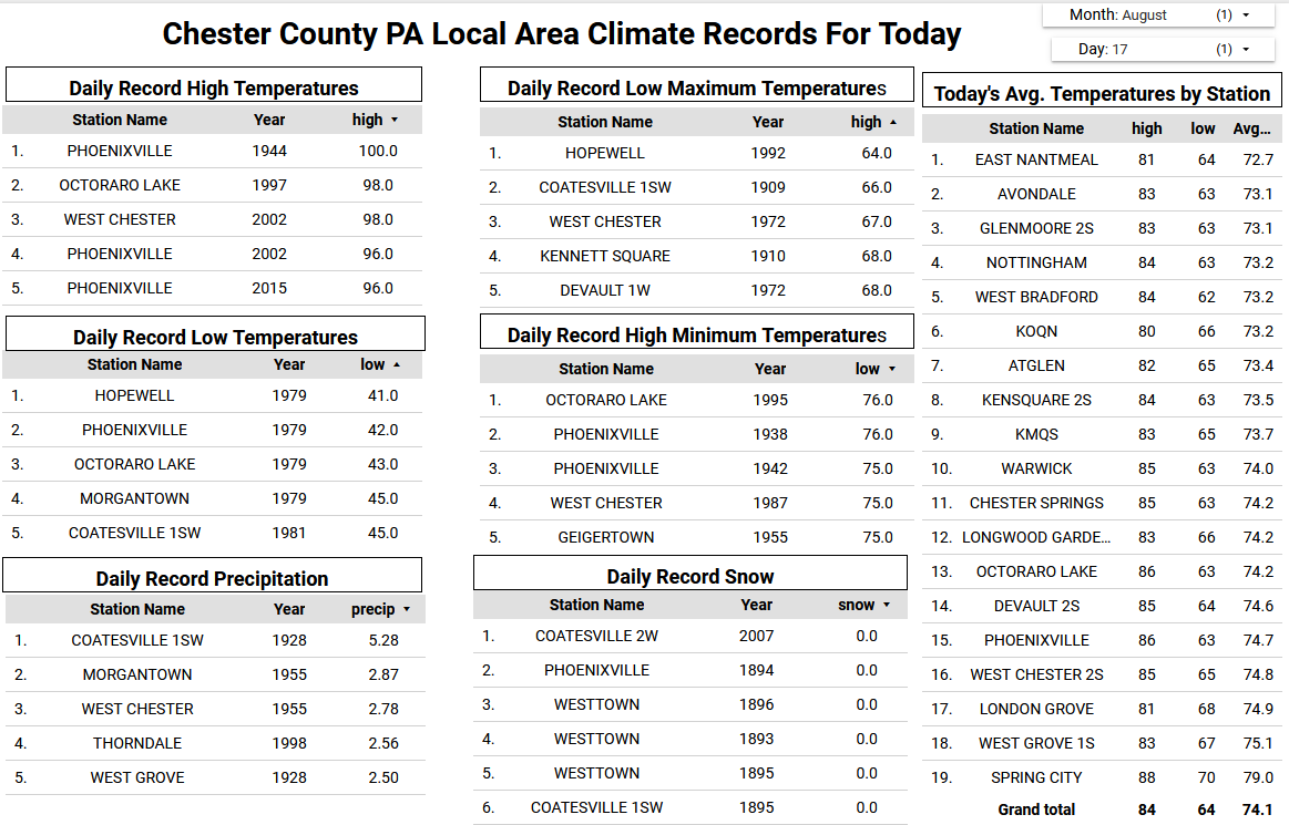
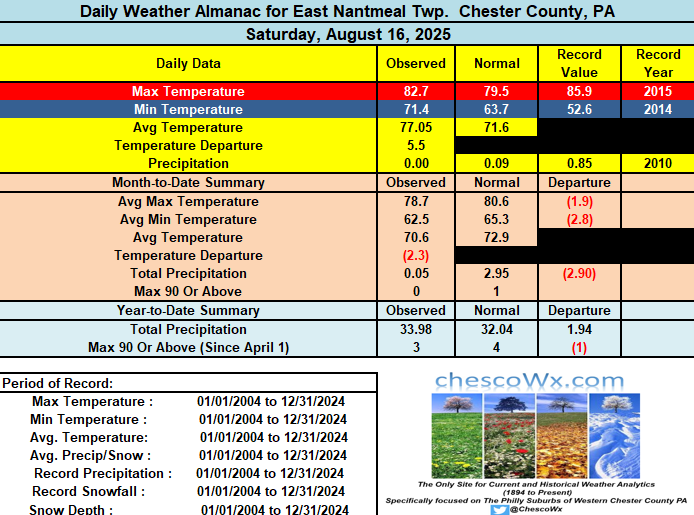
Today will be our 6th straight above normal temperature day. It will also be our last such day for at least the next week as we should see temperatures at or below normal levels much of the time. It looks like we have a good chance at finishing August with below normal temperatures. If so this would be the 4th below normal month over the first 8 months of the year. We could see some rain and thunderstorms especially this evening with the cold frontal passage. The line should move west to east across the area between 6pm and 8pm. Any storms could produce a 1/4" to 1/2" of much needed rain as we have had very little rain across the northern parts of Chester and SE Berks counties so far here in August.
-

E PA/NJ/DE Summer 2025 Obs/Discussion
ChescoWx replied to Hurricane Agnes's topic in Philadelphia Region
Today will be our 6th straight above normal temperature day. It will also be our last such day for at least the next week as we should see temperatures at or below normal levels much of the time. It looks like we have a good chance at finishing August with below normal temperatures. If so this would be the 4th below normal month over the first 8 months of the year. We could see some rain and thunderstorms especially this evening with the cold frontal passage. The line should move west to east across the area between 6pm and 8pm. Any storms could produce a 1/4" to 1/2" of much needed rain as we have had very little rain across the northern parts of Chester and SE Berks counties so far here in August.
-
Let's see... The last several Advisories. Not made up and documented. Adjusted forecast track "nudged" to the W. A WNW movement to continue with an "expected" turn to the N. ERIN was NEVER forecasted in the earlier advisories to be located at the present position. Just something to watch, BE AWARE, going forth. HFSA 2am. Thursday 72.3W 33.85N (closest approach) Only then a fish let off the hook.
-
My farm field needs less water. You- My corn field needs more water. Me- My corn filed needs more sunny mornings. Some other dude- My corn field needs cooler weather. Grumpy ass farmers are never satisfied.
-
it's been hot in Indiana too. What does that have to do with SNE?
-
 Not likely and it heads out ahead of Erin.
 -
Going to see that when folks are struggling.
-
Logan and BDL are near -1. Sweet spot for warmth has been ORH north and especially NNE.
-
CON hit 89/52 yesterday and only pulled a +1. A product of low dews and torched normals. 61-90 norm for 8/16 was 80/55. It’s now 82/57.
-
We have -2F cool stretches and +9 warm stretches. That’s the new world order now. Warmth wins.
-
At ORH?
-
Some cherry picking going on here. Only +1.2 after a six-day warm stretch...when we all know a cool stretch is coming. If the ground remains dry look for some overachieving rad-nights.
-
I suppose mine would be too if I had predicted 14 day heat waves and none of the majors in SNE had even a three-day. Lolz ...
-
 The low off the carolina coast, is that supposed to develop at all?
 -
The all hot all the time crowds confidence has really been shaken. 90 + with high dew forecasts have now gone to "near 90" with a bunch of qualifiers. We tried to tell em...
-

Hurricane Erin: 125 MPH - 940mb - WNW @ 14
Wannabehippie replied to BarryStantonGBP's topic in Tropical Headquarters
8:00 AM AST Sun Aug 17 Location: 20.7°N 67.0°W Moving: WNW at 14 mph Min pressure: 940 mb Max sustained: 125 mph -
We had decent rain July 31st down here on the SW coast, last rain except for a few drops.