All Activity
- Past hour
-
Some downpours rolling through. Bring back this weekend.
-

2025 Spring/Summer Mountain Thread
Met1985 replied to Maggie Valley Steve's topic in Southeastern States
A very foggy morning with a low of 40 degrees. Going to be a beautiful day. -
So not Stein?
-
Euro has a coastal Friday into Saturday with inches more. Hopefully it’s wrong. Either way, starting Mothers Day looks like a nice run of 70’s and 80’s
-
.thumb.jpg.6a4895b2a43f87359e4e7d04a6fa0d14.jpg)
Central PA Spring 2025
Yardstickgozinya replied to canderson's topic in Upstate New York/Pennsylvania
It's worth reading fellows. I'm excited about today and tonight. I hope last night is an indicator of where storms may start training today. Area Forecast Discussion National Weather Service State College PA 501 AM EDT Mon May 5 2025 .SYNOPSIS... * Slow moving, training showers and PM thunderstorms will lead to localized heavy rainfall of 1 to 2+ inches with the potential for small stream and poor drainage flooding in a few locations across Central Pennsylvania and the Western Mtns. *Becoming drier late in the week with a trend toward below normal temperatures. && .NEAR TERM /THROUGH TONIGHT/... A quasi-stnry front stretched about 25 NM either side of Interstate 80 (along its entire length through PA) has helped to strengthen several narrow bands of showers overnight as they drifted NNW over the boundary that provided some enhanced MESO-B lift. As we head through the late morring and into the afternoon hours, the focus for the most numerous bands of convection and threat for heaviest rain and localized severe weather will be across the approx SW 1/2 of the CWA today as 2 separate mid/upper level jet maxes/lobes of differential vort lift north across the Western and Central Mtns. Slightly lower probs for severe weather and training heavy SHRA/TSRA exist across the Middle Susq Valley and Endless Mtns region NE of KIPT. The first of the aforementioned kinematic features aloft will be the enhanced lift/focus for the initial TSRA beneath the right entrance region of a upper level speed max stretched from KPIT to KCLE late this morning through early this afternoon, followed by a link with meso-B uvvel beneath the left exit region of another southerly jet segment drifting north across VA and the MD Panhandle toward evening. A distinct channel of enhanced (deep and somewhat thin) CAPE of 1000-1500 J/KG will exist between RT 219 in the Western Mtns and RT 15 north through the Susq Valley. Later shifts will need to keep a close eye on the evolution of convection and training cells within this part of the CWA (which covered by WPC`s MRGL risk of excessive rain), as PWAT values will be just under 1.5 inches coinciding with soundings that indicate a deep, moist, warm cloud layer up through 11-13 kft agl leading to highly efficient rainfall production. A short- fused Flood Watch may need to be collaborated/issued at some point later this morning/afternoon. Max temps will display a small range today (only about 5-6 deg F) from the upper 60s to low 70s. A few spots throughout Scent PA could see a 74 or 75F this afternoon. SPC maintains a MRGL risk for stronger updrafts containing 1 inch hail and locally damaging wind gusts. As noted by earlier shifts, although not outlooked for tornadoes, a brief, weak tornado can not be ruled out given the low LCLs and sufficient veering/moderately strong llvl speed shear within the wind profile at low levels. Convection may be slow to wane tonight, with both the NAM and HRRR showing potential for narrow swaths of 1-2" of rain falling from mature convective lines and clusters in just the 12 hour period from 00z-12z Tue. && .SHORT TERM /TUESDAY THROUGH WEDNESDAY/... Active weather will likely continue Tuesday/Tuesday evening as the core of the upper low moves into western PA. This will push the highest instability and greatest chance for severe weather east into the Lower Susquehanna Valley. The threat for severe weather appears to decrease Wednesday as the slow moving upper low gradually fills in and the center moves across the Eastern Third of the state in the afternoon, with precip likely coming to an end across the bulk of Central PA by Wed evening. && .LONG TERM /WEDNESDAY NIGHT THROUGH SUNDAY/... By the latter half of the week, the upper low will be replaced by a fairly potent upper trough as high pressure builds in at the surface. Much lower PWATs (0.25 - 0.75") will usher in a stretch of cooler and less-rainy conditions for the weekend. Cool temps aloft will keep a chance for diurnal showers in the forecast each afternoon, but ensemble mean rainfall for the period is less than a quarter inch across the whole area. High pressure amidst a cooler airmass will support a risk for frost Friday and Saturday morning, especially west of I-99 and north of I-80. The growing season is currently active for only the counties along/east of I-99 and along/south of I-80, but as we approach the median date of the first freeze for much of the Laurel Highlands and northwest mountains (May 11th), Frost/Freeze products may be needed there later this week. After the brief cool snap Thursday night through Friday night, ensembles favor a return to near normal temperatures with highs in the 60s to 70s and lows in the 40s to 50s -
.49 vs 1.09 since yesterday? I’d say so . Especially when E CT was modeled much drier
-
0.9” Fri thru Sun
-
0.5” here since midnight. 0.65” yesterday. the nickels add up
-
I see 0.49” (24hr) and 0.98” (May) for you? Is that much less?
-
.82 yesterday. 2 day total: 1.67”
-
It’s pretty cool seeing those “waves” on the northern fringe as the dry air interacts with the stretching deformation. Meanwhile the southerly firehose keeps crashing into it. A steady dumping of rain all night.

-
Much more than this area
- Today
-
46.1 degrees at 5:20. This beat the NWS expected low of 53 by far!!!!!
-
About .66” overnight and 1.08” since Thursday in E CT
-
"Unsettled weather will continue much of this week with showers/isolated thunderstorms that will produce heavy rainfall at times. Appears we may briefly dry out by Thursday, before more rain arrives Friday into Saturday. Depending on how much rain falls, we could see rises over bankfull on larger rivers and smaller streams across interior Southern New England." Swell...
-
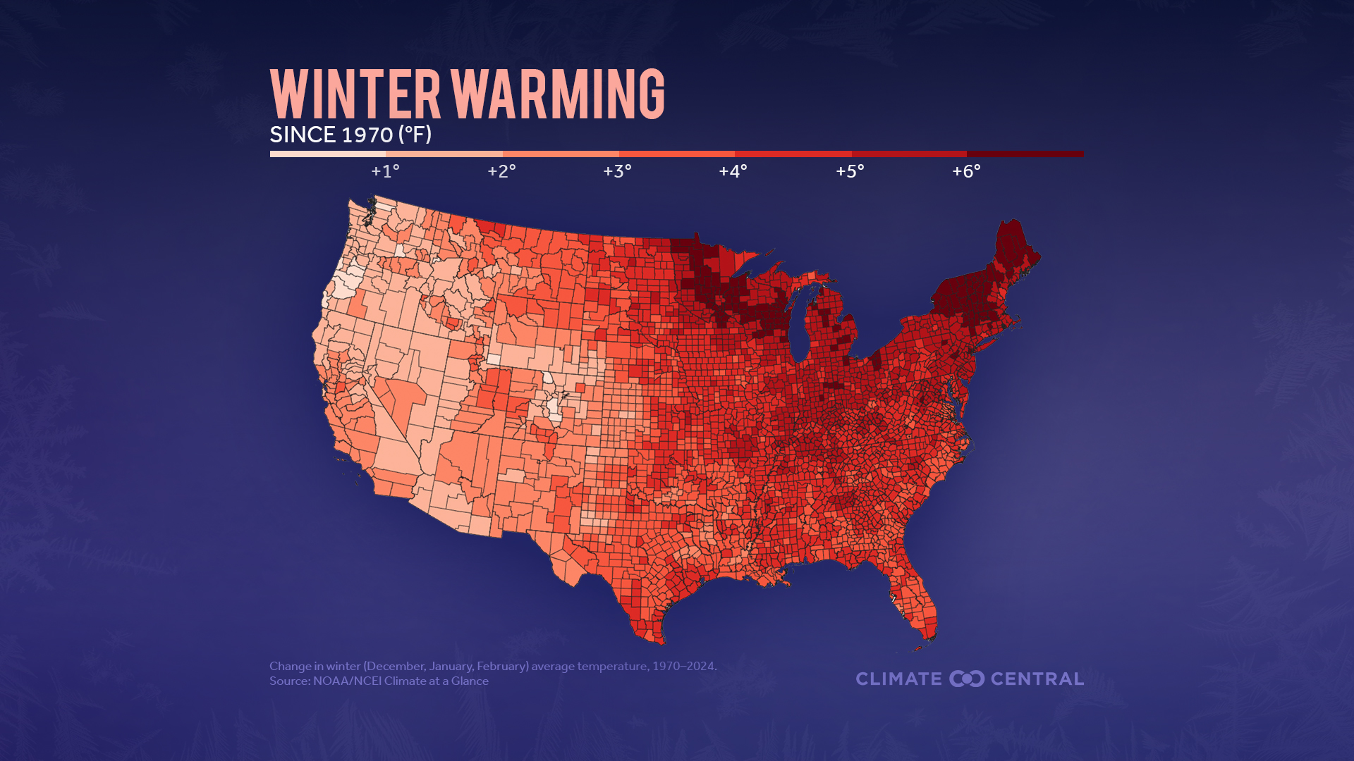
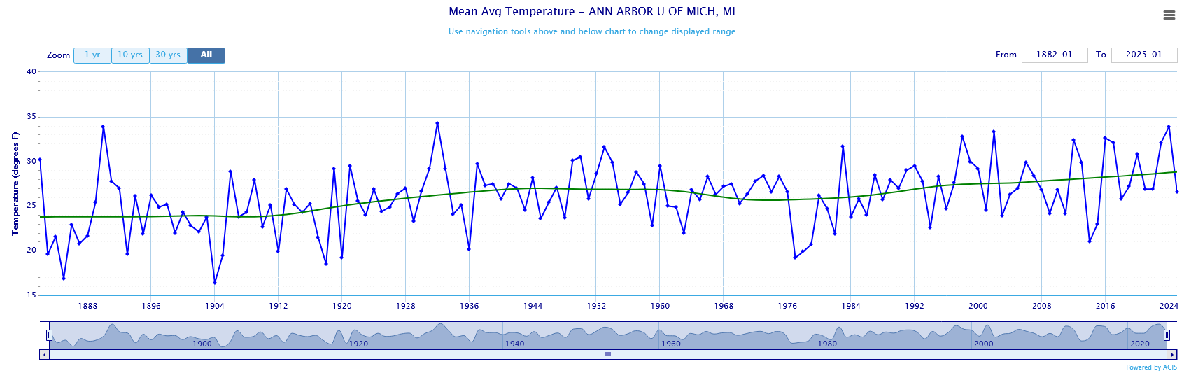
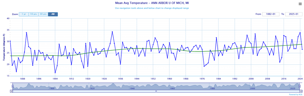
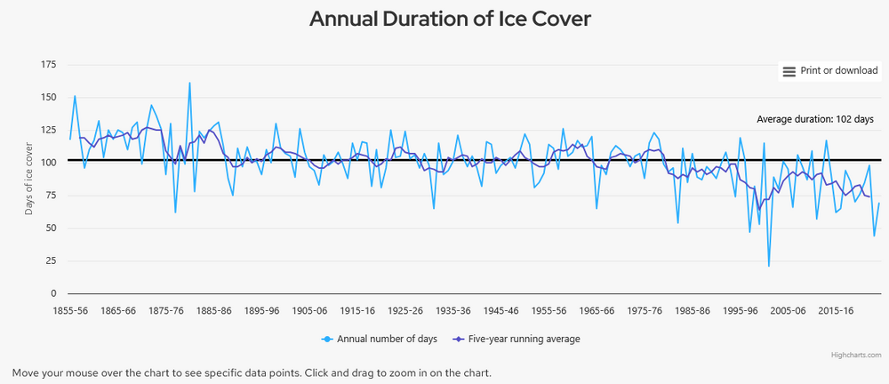
We've discussed the problem with comparing city and airport obs in Detroit and Chicago before. Need to maintain consistency or remove station changes to isolate the long-term climate trend. Winter warming has been uniform across the eastern US. If anything warming increases slightly from south to north. The fastest warming is in the upper midwest and northern New England. The warming map is confirmed by long-term data from Ann Arbor and lake freeze data from Mendota Lake in Madison Wisconsin.

-
Central PA Spring 2025
Yardstickgozinya replied to canderson's topic in Upstate New York/Pennsylvania
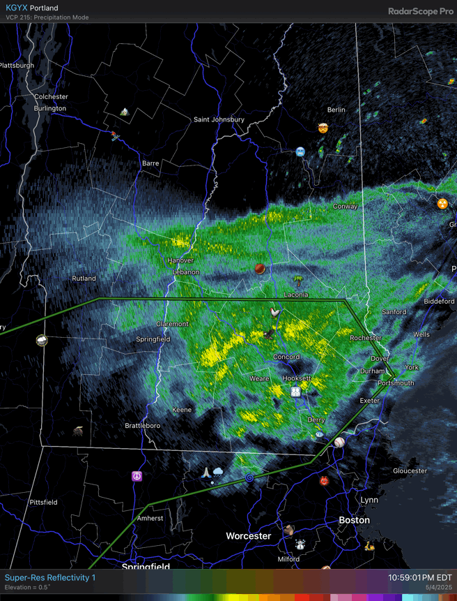
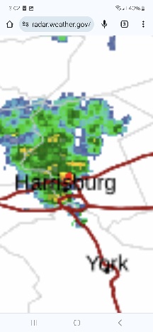
I only got a little drizzle yesterday but around 1:30am this morning this slow moving precipitation cell set up perfectly centered over my neighborhood and gave me a very nice steady rain for at least fifty minutes. It looks like Harrisburg is doing well now to from this slow mover.

-
December Natural Gas contract is almost right at $5... I usually say below $5 favors +NAO, and above $5 favors -NAO.. below $3 stronger +NAO, and above $8 stronger -NAO.. So right now almost exactly neutral on NAO prediction there. March '26 Natural Gas is $4.20.. a slight +NAO lean for later in the Winter.
-
QBO should be negative.. March to April went from +11 to +6. When it changes phases it usually lasts at least 10 months. -QBO with El Nino favors Stratosphere warmings, but ENSO looks to be more Neutral this Winter. -QBO's with neg-Neutral ENSO have been known for cold December's then switching to warmer Jan-Feb (89-90, 05-06), but there's not enough data to say that for sure. My N. Atlantic SST method predicted +0.52 NAO last Winter (DJFM), and it ended up being +0.65. That makes it 15-5 on getting the right sign in real time since I came up with it in 2005. Also 11-9 within the estimated standard deviation of +0.54. The index runs May-Sept, so it's too early to say where it's going right now.
-
CPC's DJF 2025-26 Winter outlook
-

E PA/NJ/DE Spring 2025 Obs/Discussion
Albedoman replied to PhiEaglesfan712's topic in Philadelphia Region
-
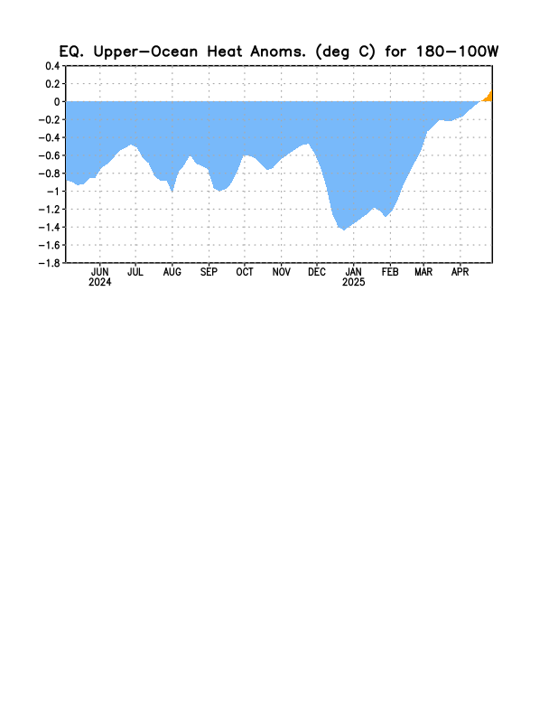
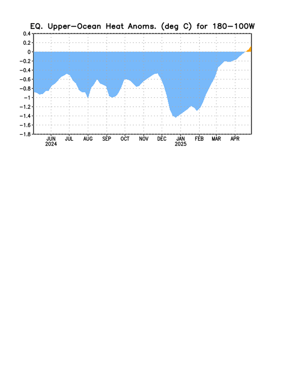
We now have a +OHC!
-
You can read about meteorological features, but it’s fascinating to see it all play out in realtime. Do you think some of those high end QPF depictions the next few days have a chance of verifying? I lean toward the Euro being more right than not, though I think it’s running a little hot. It’s not alone though.
-
I have been home from Florida for 65 days and I think we've had maybe 20 decent days. I'd be okay if we deleted march and April from the calendar.
-
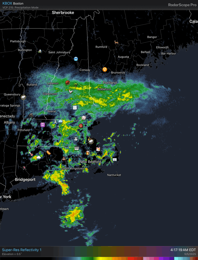
And here’s how that looks like on radar.