All Activity
- Past hour
-

September 2025 OBS-Discussion centered NYC subforum
cleetussnow replied to wdrag's topic in New York City Metro
I was talking about like, the middle of the Sahara desert, the south pole, top of the Himalayas, bottom of the atlantic. Wasnt a climate remark. most famines in the last 100 years are caused by wars and other types of political unrest such as happened in China after Mao took over. Not commonly due to weather, not anymore. Famines are less common now than the last say, the last 200,000 years of human history thanks to technology. -

September 2025 OBS-Discussion centered NYC subforum
Big Jims Videos replied to wdrag's topic in New York City Metro
Sitting and sweating outside in the yard under a pure blue sky. Water temps still in the 70s. Endless summer rolls on. ☀️☀️ -
5 GEFS members keeping weenie hopes alive
-

September 2025 OBS-Discussion centered NYC subforum
donsutherland1 replied to wdrag's topic in New York City Metro
I didn't use dense ranking. But yes, it would be tied for 16th most using dense ranking. -
They said a week or two ago that the calf injury was not recovering as fast as they hoped, and the said last week that he was still rehabing. Sounds like just one of those things... And btw our fanbase lost the right to complain about few injury updates after Lamar 2022, lol On that I agree with Harbs: I ain't telling y'all NOTHIN'
-

September 2025 OBS-Discussion centered NYC subforum
SACRUS replied to wdrag's topic in New York City Metro
80 / 63 here -
September 2025 OBS-Discussion centered NYC subforum
SACRUS replied to wdrag's topic in New York City Metro
If you eliminate duplicate years it's 16th place and 18 behind 2015. Year Rank Days >= 80 °F 2015 1 118 2024 2 117 2021 3 116 1994 4 114 2016 5 113 1993 5 113 1991 5 113 2011 6 111 2010 6 111 2023 7 110 2022 8 109 1959 9 108 2007 10 106 2005 11 105 2002 12 104 1990 13 103 1957 13 103 1983 14 102 1906 14 102 1989 15 101 1986 15 101 1949 15 101 1908 15 101 2019 16 100 2017 16 100 -
Da fuck is going on with Ricard? A calf injury since training camp and there are never any updates. Figures after he was signed to a big contract. Need the dude back because the starting guards are so mediocre. Which brings me to Ben Cleveland. Forever in the Harbaugh doghouse because he doesn't like the way he practices- yet every time he does get in an actual game he performs well. A natural guard and better than Filet-lea, the human turnstile.
-
Picked up 0.2” yesterday, the evening moderate rain helped.
-
BOS will definitely be in positive territory after today. A +15 is on the table.
-
Occasional Thoughts on Climate Change
donsutherland1 replied to donsutherland1's topic in Climate Change
This is why I periodically call attention to social media influencers and celebrities (i.e., Bastardi, Wielicki, Martz, etc) on X and elsewhere. They push themselves as climate experts when they have little or no knowledge of climate/climate change while frequently attacking scientists who have devoted their lives and careers to cutting-edge research. These influencers/celebrities see things only in terms of cherry-picked ideas in their own fields constrained by their own ideology and personal preferences, to distort the science and undermine public understanding. Moreover, they prey on public ignorance to build their status. -
why/how/in what way does ace matter for winter? i've seen a few people mention it before but its not widely described
-
Looks like a PAC jet from hell winter to me…
-
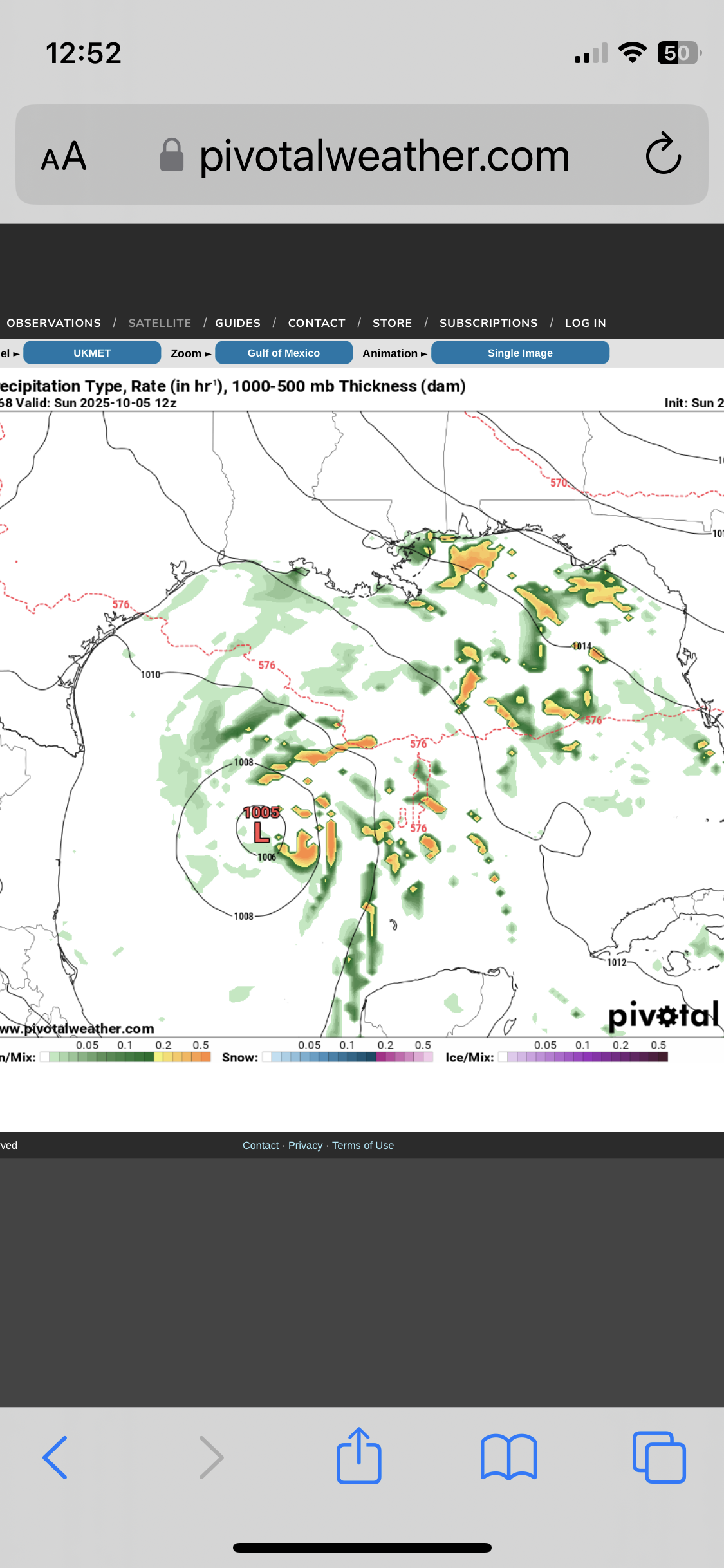
I wasn’t paying any attention to the Gulf at all due to Humberto and TD9 til just now. I just noticed on the most recent runs that just about all models have a weak but notable surface low/spin initialized in the C Gulf that then drifts SW to the Bay of Campeche, where it seems to stall just W of the Yucatan at ~hour 96. Interesting. And lo and behold, there’s a TD on the UKMET (12Z) for the first time in the Bay of Campeche at hour 120 that then drifts N through the end of the run to a threatening position in the W central Gulf. I just saw new UK maps and this UK TD is from the same low that’s now in the C Gulf! NEW TROPICAL CYCLONE FORECAST TO DEVELOP AFTER 120 HOURS FORECAST POSITION AT T+120 : 20.7N 93.3W LEAD CENTRAL MAXIMUM WIND VERIFYING TIME TIME POSITION PRESSURE (MB) SPEED (KNOTS) -------------- ---- -------- ------------- ------------- 1200UTC 03.10.2025 120 20.7N 93.3W 1009 26 0000UTC 04.10.2025 132 21.1N 93.0W 1007 25 1200UTC 04.10.2025 144 22.3N 93.0W 1005 30 0000UTC 05.10.2025 156 22.8N 92.8W 1004 24 1200UTC 05.10.2025 168 24.4N 92.8W 1005 26 ——————— 12Z UKMET at 168 hours: this TD originates from the current C Gulf low and this becomes a TD on this run at 120, which moves N to this position at the end of the run (168): Also, check out the 12Z GFS at 168: there’s a TD that forms off of LA that then moves N into that state. That may or may not be directly related to the current C Gulf low, however, based on looking at vorticity maps.
-
In what way?
- Today
-

2025-2026 ENSO
40/70 Benchmark replied to 40/70 Benchmark's topic in Weather Forecasting and Discussion
I don't agree. I can't find on piece of data that argues against it...don't mean it will necessairly work out, but I the point is I see. no reason to bet against it....polar analogs, weak, basin-wide to east-based La Niña, strong E QBO/near solar max, normal to above average ACE.....name it. -
Looks like a great winter for...Cape Hatteras?
-

September 2025 OBS-Discussion centered NYC subforum
psv88 replied to wdrag's topic in New York City Metro
0.08 total from the latest event. another top 10 day. Rack em up -
September 2025 OBS-Discussion centered NYC subforum
donsutherland1 replied to wdrag's topic in New York City Metro
No. The ice wasn't sufficiently thick. -

Fall 2025 Medium/Long Range Discussion
michsnowfreak replied to Chicago Storm's topic in Lakes/Ohio Valley
You're jumping the gun though. I know you said "if". But dry mild Falls followed by wet winters is a very common theme for ninas in the midwest/Great Lakes. -
September 2025 OBS-Discussion centered NYC subforum
donsutherland1 replied to wdrag's topic in New York City Metro
Newark has reached 80F (26.7C) for the 100th time this year. That is tied with 2017 and 2019 for the 21st highest number of days. 50% of Newark's years with 100 or more such days have occurred since 2000. -
 Typhoon Neoguri is a fully tropical 120-mph cyclone way to the east of northern Japan, at 38N/167.3N. SST’s in this area are up to 4C above normal. I’m not sure exactly what the records are for this area of ocean, but I can’t remember any typhoons reaching this far northeast without becoming extratropical.
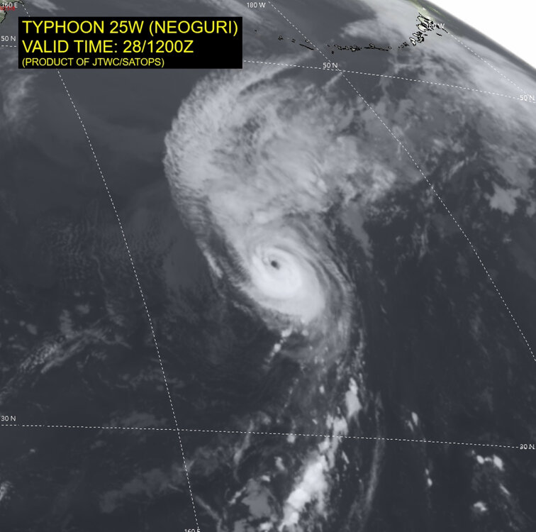
-

September 2025 OBS-Discussion centered NYC subforum
LibertyBell replied to wdrag's topic in New York City Metro
I love bright sunny days with deep blue skies so I'm happy. The contrast between today and later in the week when we again have deep blue skies but much cooler weather will be very interesting. -
September 2025 OBS-Discussion centered NYC subforum
LibertyBell replied to wdrag's topic in New York City Metro
Don would people have been able to walk from Long Island to Connecticut and vice versa? -
 (Hope the mods don’t mind me sharing this) I’m sharing - and looking for feedback on - a project I’ve been working on this summer. Its origins were an idea I’ve had for nearly 20 years - to create a platform where accurate information is elevated and showcased and helps improve the medium-range forecast information available to the general public. My idea was always to start with hurricanes, since forecasts are “easier” to measure for accuracy. https://hurricanehive.com/ Tldr; For anyone who wants to create medium-range forecasts: I built tools to create hurricane forecasts and then get accuracy assessments (alongside NHC and some computer models (hopefully more soon). For the general pubic (think of your friends and family): I also have put work into synthesizing the information into clear, digestible, hype-free forecast products. I think there is a serious information gap between the information available that can help people understand the medium-range risks and what they consume - increasingly through social media or weather apps that are very good at hourly / short-term forecasts. (yes, I am using AI - more on that below). I had time this summer and set out building it, which has been fun. If I get traction, I am want to extend this to a year-round product/service. Of course, I picked the tropical season of 2025, which has been devoid of long-track landfall threats… But I would love feedback - if you want to sign up and try the forecasting tools, you have options to keep them to yourselves or make them available for the public. I have the jobs to calculate accuracy in place, and will build out the front-end in the coming week or so. Initially I thought about leaning into a “leader board” approach, but don’t want that to scare people away from participating. I’d l love your ideas. And hopefully there will be more to track... For all you weather geeks, whether you want to forecast or not.. the entire storm archive back to 1851 is here, along with tools to search storms and create collections (if you register). I can also generate analog storms. How the forecasting works: when you register you can indicate you want to forecast (and whether you want to share them or not) Under /forecast - you can create a new forecast for each storm within 4 hours of the latest storm position update (so after 11 AM ET you have until 3). You can enter forecast points for any of the standard plots up to 120 hours and add an optional landfall point. Thanks for looking/listening and feedback. More (from my FAQ):