All Activity
- Past hour
-
Don’t worry buddy, we’ll get ya to snow one more time.
-
SPC already has a 45% area for Day 3 in S IN, S IL, and W KY.
-
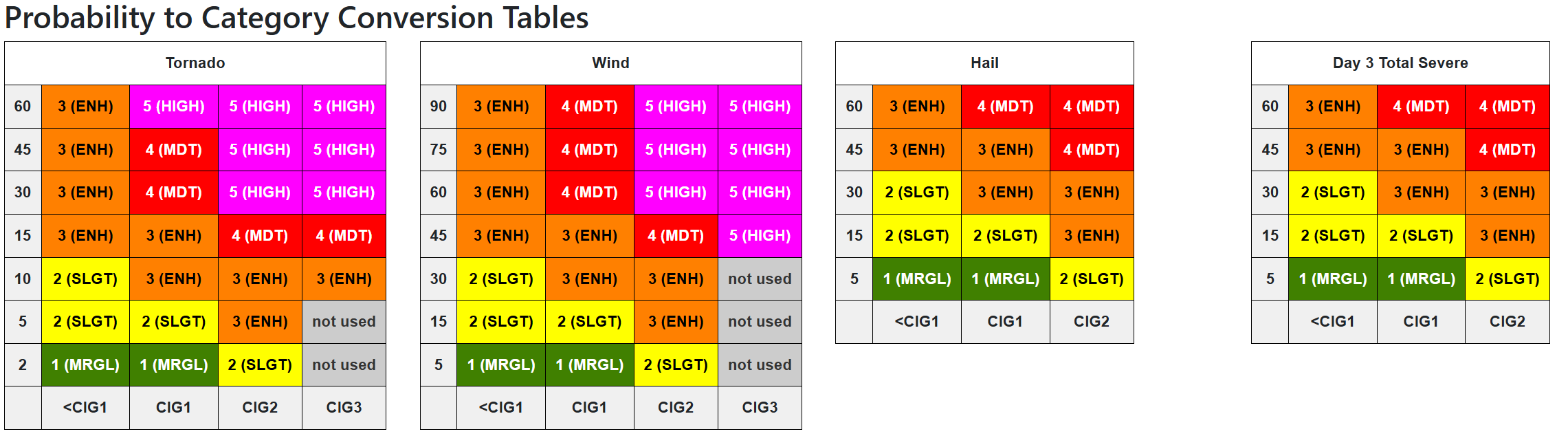
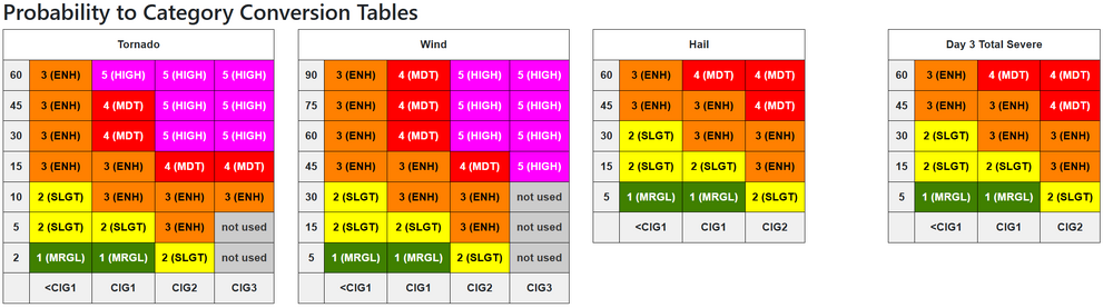
Remember the new conversion tables
- 173 replies
-
- 1
-

-
- severe
- thunderstorms
- (and 7 more)
-
Van Wert (of course lol) wants to kick off the weekend with an 80mph Tpole snapping semi flipping dust storm lol. Tis a bit breezy with multiple 60+ gusts here. for the last 4-5 hours. most N/S highways and Interstates are closed with flipped semi's around here. Preliminary Local Storm Report National Weather Service Northern Indiana 127 PM EDT Fri Mar 13 2026 ..TIME... ...EVENT... ...CITY LOCATION... ...LAT.LON... ..DATE... ....MAG.... ..COUNTY LOCATION..ST.. ...SOURCE.... ..REMARKS.. 0115 PM Non-Tstm Wnd Dmg 2 N Van Wert 40.89N 84.58W 03/13/2026 Van Wert OH Emergency Mngr Multiple semi trucks rolled over and power poles down in Van Wert county. A lot of blowing dust too.
-
I mean if it continues I see 45% wind hatched at least for sure
-
Good lord this wind is kinda shitty.
-
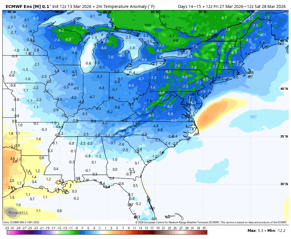
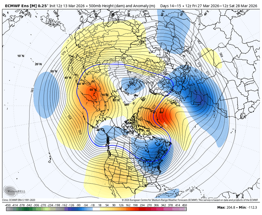
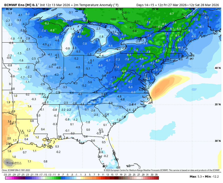
WB 12Z EPS: may be a month too late but worth keeping an eye on the last weekend of March period.
-
Not really.
-
that's top tier for a synoptic wind event in this region.
-
86 mph gust at KMIE. Multiple semis blown over on I 69 south of FWA.
-
Yeah wowza thankfully the moisture isn’t there but still adequate .
-
LWX afternoon AFD DISCUSSION... KEY MESSAGE 1...A strong cold front will arrive Monday, bringing strong winds and the potential for severe thunderstorms. The Mid Atlantic should be in the warm sector of a powerful low pressure system over the Great Lakes on Monday. A deep upper trough pushing east of the Mississippi Valley will be taking on a negative tilt. Winds throughout the atmosphere will be very strong, along with notable low level wind shear (though more speed than direction). Dew points in the upper 50s to lower 60s and modest mid level lapse rates will limit instability but there should still be enough to support convection. The thermodynamic profile could be one of the primary factors into just how significant the severe weather is. There is some threat for some leading cellular development in the warm sector which could pose a wind and tornado risk. Then, a squall line is likely to develop ahead of the sharp cold front. Damaging winds, some potentially significant, will be a threat with the squall line. A QLCS tornado threat could also be present, although the shear vectors will be more parallel to the line vs. the more favorable perpendicular. Seasonally high precipitable water will also result in heavy rain, although storms will be moving quickly. Timing is still a bit uncertain, but the most favorable conditions combined with afternoon/early evening timing are projected east of the Blue Ridge. SPC has highlighted a somewhat rare 30 percent day 4 severe outlook for this area. Besides the convective winds, gradient winds will also be strong immediately ahead of and behind the front which could cause additional localized tree damage and/or complicate recovery efforts. Cold air will be rushing in immediately following the frontal passage. At a minimum, the Allegheny Mountains will change to snow for a time in upslope conditions. It remains uncertain if any postfrontal precip lingers to the east long enough to change over.
-
Look at this hodograph from the NAM for NE Arkansas on Sunday afternoon. .
-
The 2002 Christmas night storm was forecast 8-12" here and verified at 1". Belgrade Village, less than 10 miles southeast, had 8", parts of AUG had 15" and GYX 18", their biggest on record until Feb 2013, still in 3rd place.
-
They don't... unless absolutely necessary
- 173 replies
-
- 1
-

-
- severe
- thunderstorms
- (and 7 more)
-
Bullish
-
Oh I never realized they did d4-d8 updates
-
I don't remember SPC ever updating a Day 4-8 disco before? @high risk @andyhb Day 4-8 Convective Outlook AMEND 1 NWS Storm Prediction Center Norman OK 0304 PM CDT Fri Mar 13 2026 Valid 161200Z - 211200Z AMENDED TO EXPAND D4/MONDAY THREAT AREAS ...DISCUSSION... ...Updated discussion for D4... The majority of deterministic and ensemble model guidance agree on a deep midlevel trough and associated cold front that will move eastward across the Appalachians and to the Atlantic coast by Tuesday morning. Severe storms could be ongoing at the beginning of the period along the northeast Gulf coast into GA. The warm sector, characterized by boundary-layer dewpoints in the 60s, will expand northward (generally east of the Appalachians) through the day as far north as PA. Though clouds could limit downstream surface heating somewhat, very strong wind profiles and focused forcing for ascent will favor a continuation of convection along the front, as well as pre-frontal convection, with the potential to produce relatively widespread damaging winds and several tornadoes.
-
The image yes
-
Is that new? the disco looks the same
-

2026 Mid-Atlantic Severe Storm General Discussion
Eskimo Joe replied to Kmlwx's topic in Mid Atlantic
-
just 15 short days away
-
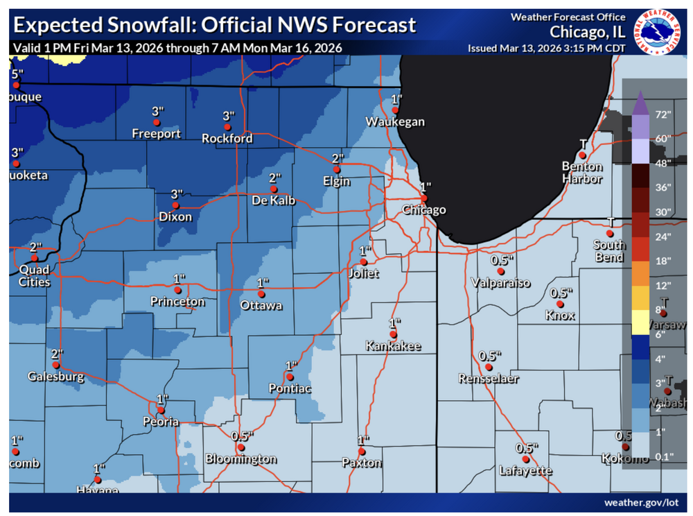
Chicago NWS Thelatest thinking is that snow accumulations would generally be in the 2-4 inch range (60-80% chance) for this event with the highest amounts forecast to occur north of I-80 and in northwest IL. However, there remains a 15-20% chance for localized amounts upwards of 6 inches to occur. Regardless of the snow amounts, the main concern with wintry side of this system will be the threat for blowing and drifting snow as gusty northwest winds develop behind the low. With wind gusts expected to be in excess of 40-45+ mph Sunday night into Monday any falling snow will be blown around and if snow can be "fluffed" up enough as temperatures cool then some drifting snow may also materialize leading to hazardous travel. Given that there is still uncertainty in snow amounts, rates, and character we have opted to hold off on issuing a Winter Storm Watch with this forecast package. Though if trends continue then a consideration for a winter weather headline will be needed with future forecasts.
-
I noticed that too. It definitely was kinda weird there. The wind just gusted pretty crazy here.
-
I dunno, end of the month keeps popping up on various modeling for winter wx impacts throughout SNE.