All Activity
- Past hour
-
 Pretty wild environment as expected and there is already decent instability in place and satellite suggests that there will be at least partial breaks to allow for additional destabilization. What's really eye popping to me right now is 200-300 m2/s2 of effective storm-relative helicity and you have ~20 knots of sfc-2km winds which are nearly due easterly (inflow winds). The timing of the forcing out west looks more than favorable too. Mesoanalysis (using RAP background) gets 3km CAPE values >100 J/KG later this morning and early afternoon...pretty eye opening given the shear magnitudes.
 -
 Sun poking through now in tysons
 -
Pretty similar to 2017-2018, just flip February and March and slit the snow between Jan/Feb.
-
Yeah I consider March 2018 to be king in my lifetime. Oct 2017 and 2021 were both good but they happened at night and the damaging winds didn't last for as long as in March 2018. Unless you live on the immediate coast, wind is usually underwhelming in New England.
-
Doesn’t really look interesting going forward. Suckbag ending.
-
 the warm air is definitely surging into the region. Nanjemoy mesonet site already up to 67 degrees.
- 321 replies
-
- 2
-

-
- severe
- thunderstorms
- (and 1 more)
-
 https://www.spc.noaa.gov/products/md/md0268.html Mesoscale Discussion 0268 NWS Storm Prediction Center Norman OK 0740 AM CDT Mon Mar 16 2026 Areas affected...Parts of central Virginia into central North Carolina Concerning...Severe potential...Watch likely Valid 161240Z - 161445Z Probability of Watch Issuance...80 percent SUMMARY...The potential for damaging wind gusts and tornadoes will gradually increase into parts of central North Carolina and Virginia through the morning into this afternoon. A watch issuance is likely. DISCUSSION...A remnant QLCS is emerging east of the Appalachians, where it is showing some early signs of re-intensification. Farther east, a disorganized band of thunderstorms is also evolving over parts of western VA into NC. While overall convective evolution is not clear, these storms will continue spreading eastward into a destabilizing air mass (around 500-1000 J/kg MLCAPE). Despite the somewhat limited buoyancy, strong low/deep-layer shear characterized by clockwise-curved low-level hodographs (see GSO 12Z sounding) will favor a mix of organized line segments and supercells, with a risk of damaging wind gusts and a few tornadoes (some potentially strong). A watch issuance is likely for this activity. ..Weinman/Hart.. 03/16/2026 ...Please see www.spc.noaa.gov for graphic product... ATTN...WFO...AKQ...LWX...RAH...ILM...RNK...CAE...GSP... LAT...LON 35018062 36058067 37938001 38327941 38387851 38157795 37767769 37037785 35917834 35137889 34707944 34798025 35018062 MOST PROBABLE PEAK TORNADO INTENSITY...100-130 MPH MOST PROBABLE PEAK WIND GUST...65-80 MPH MOST PROBABLE PEAK HAIL SIZE...UP TO 1.25 IN
 -
 I'm hoping my truck gets picked up a little bit and humbles the crap out of me while I'm watching an EF3 ripping across an open field on the eastern shore or across the bay. Who's rooting for an urban nightmare storm? I drove down to LA Plata MD after the EF5 (Yes it was 100% an EF5.) I saw things I'd never imagined wind could do. I talked to a girl that was in shock the following day. She had a blank stare on her face and wouldn't talk. Her father said she was in shock and didn't know what happened. They brought her back to the taco bell she was working at when the monster struck. The entire place was gone except one little wall where the bar stools were bolted to the foundation. The tornado actually missed the building by 50 yards. It ripped the concrete off the ground and dug into the top soil where the direct patch was. I think the girls father told me that his daughter's co working was still missing at the time. (Later found dead.) So.. that said. It was an absolutely beautiful tornado. I wish I was able to have seen it from a safe distance. I'd never wish for what happend to that young lady from the taco bell.
- 321 replies
-
- 1
-

-
- severe
- thunderstorms
- (and 1 more)
-
64, dense overcast with a bunch of crud developing and moving into triangle area. Think the area of clearing is thin at best
-
Storm Prediction Center Mar 16, 2026 1300 UTC Day 1 Convective Outlook -----issued 8:32 EDT SUMMARY.. Fast moving thunderstorms may become widespread and accompanied by the risk for damaging wind gusts and a few tornadoes across the Mid Atlantic today. There is potential that a couple of storms could become capable of producing strong and long track tornadoes. ...Southeast States... An intense upper trough continues to deepen over the Mid MS Valley, with its associated surface cold front surging eastward across the Appalachians and into the Carolinas/Mid-Atlantic. An active line of thunderstorms is accompanying the front from GA into western SC/NC/VA. Low-level winds are very strong along and ahead of these storms, encouraging the risk of numerous severe wind gusts and embedded QLCS tornadoes along the line. Clusters of thunderstorms have been developing ahead of the line as well, in a moist and strongly sheared environment. These storms will also pose a severe/tornado risk through the day as the primary large-scale ascent arrives.
-
 About to get hit by this. Will report back. Some peeks of sun this morning. There is also clearly a good deal of wind shear. The breaks in the clouds reveal different layers moving in different directions.
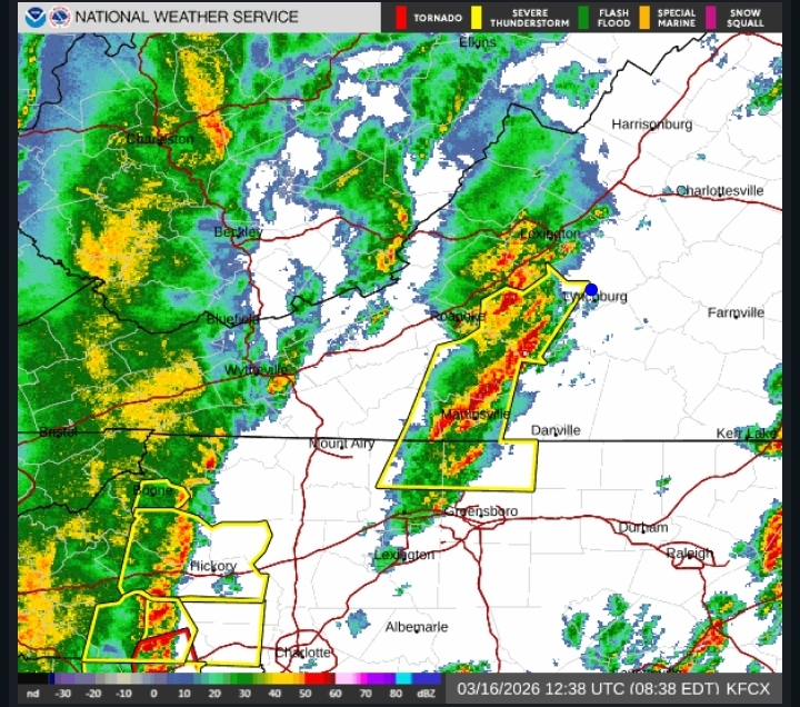
- 321 replies
-
- 1
-
-
- severe
- thunderstorms
- (and 1 more)
-
Yea, I've pretty much checked out.
-
The line just moved through my neck of the woods. No lightning, heavy rain and maybe a few gusts to around 30mph. It’s definitely getting its act together as it marches east though. A lot of Charlotte cams showing the same clearing I saw earlier. What are you folks seeing further east?
-
Deepest snow since mid December. Neighborhood kids and golden retrievers have been loving it. Happy spring! .
-

Central PA Spring 2026 Discussion/Obs Thread
Itstrainingtime replied to Voyager's topic in Upstate New York/Pennsylvania
Sounds like the early part of the afternoon offers the best chance for a Tornado and then the evening line is likely to be focused on straight line winds. Sort of surprised to see that the actual front that would contain damaging wind gusts doesn't come through here until after 8pm. This seems a good bit later than I was hearing yesterday. -
Was referring to the period as a whole should for the 7 - 10 days be near normal - a couple of colder days mixed in with normal/ warmer days.
-
Yall are going to get smoked later! Enjoy fellas.
-

Richmond Metro/Hampton Roads Area Discussion
wasnow215 replied to RIC Airport's topic in Mid Atlantic
Not much juice on here about severe today. People need to really pay attention it could be pretty darn bad. -
I've realized that my true passion is snowstorms. I guess I'd also be interested in a tropical system or severe storms if they panned out, but cutters bore me, generally. Need something damaging like Oct 21 to peek my interest, or early March 2018
-
Not even a clap of thunder! We’re lucky it’s moving through in the morning though, it’s impressive how well it became organized when it hit higher dews east of the escarpment. It’s going to be a rough day for the piedmont.
-
Yeah looks like the PV consolidated
-
@bluewavewas referring to the New York City region. Yes, the March 2012 heatwave, June 2021 PNW heatwave, April 1976 one (no longer as anomalous today due to the 2002 heatwave) are also benchmark heat events.
-
.thumb.jpg.6a4895b2a43f87359e4e7d04a6fa0d14.jpg)
Central PA Spring 2026 Discussion/Obs Thread
Yardstickgozinya replied to Voyager's topic in Upstate New York/Pennsylvania
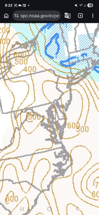
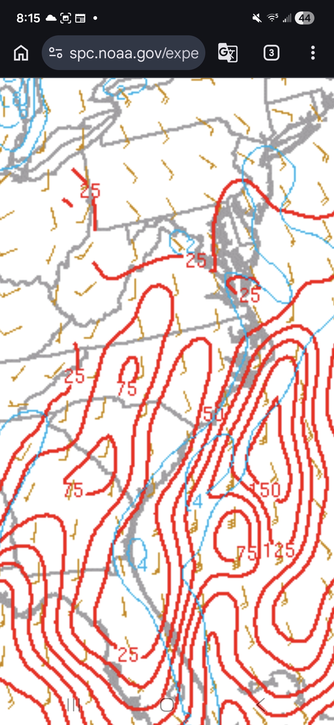
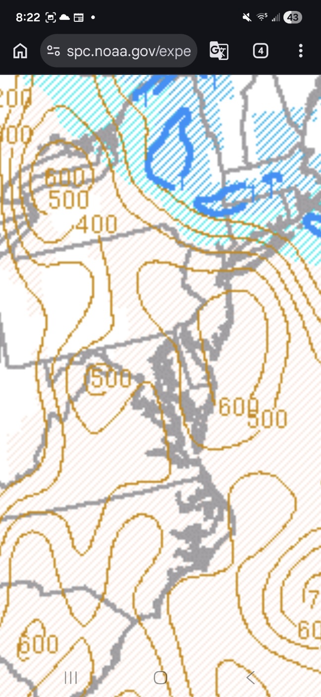
It's still early in the day, but meso scale data has been updated and at this juncture we are missing 2 of the most important parameters for tornadoes, surface cape and surface velocity (top graphic) are basically not existing at this point. There is a slight overlap in the chesapeake, but a surface cape of 25 and a surface velocity 2 is most likely not producing a tornado. There's also, some areas of extra overlaps around the Hagerstown area with some other meso scale parameters ,but nothing exceptional with this point. I'll be watching the surface all day as long as i'm not napping. We do have rising downdraft cape (bottom graphic) parameters so anyone who gets under convection or , even heavy rain might be in for a rough time. I'm sure no one needs any reminders, but I'm an idiot not a met., so make sure you're listening to your local met and not an idiot.