All Activity
- Past hour
-
Storms really firing up. Skies getting very dark and winds are howling at times.
-
Well I'd attach a low rest screenshot of radar but you can't even do that now.
-
Downpours missing me just a few miles to the west. Too bad because it's so dry out there. However these downpours today are so tiny that they probably wouldn't have helped very much anyway. I'm having to water my broccoli and romaine lettuce plants almost every day with this warm dry pattern. I hope we're not going back into the drought, but it appears that there's a good chance it's going to happen. Not much rain in sight.
-
Wow what a refreshing afternoon this has turned out to be up here. Currently at 77 with some clouds and a wonderful WNW wind blowing. Had lunch out on the deck as we opened it up early.
-
Some big boomers scattered about by me.
-
100%. Folks get silly sometimes. April through mid May is always a crapshoot. Even late May can sometimes SUCK!
-
i'd argue a solid moderate risk area will end up being needed/verifying for wind and qlcs tors. sometimes the spc forgets that their forecasts are coverage based.
-

2026-2027 El Nino
snowman19 replied to Stormchaserchuck1's topic in Weather Forecasting and Discussion
-
not sure what people are expecting...yeah sure this week was great but we're not staying in the 70's and 80's this time of year.
-
You can see what they're talking about on the SPC meso page in the 700mb and visible sat. I might add there's a very impressive dry line trying to out run the front in W/NW Iowa SW MN. I think any SUPS in IA. IL, WS will seed there as this area tries to race E ahead of the front. It's pretty prominent and has upper level help coming in behind it.
-
-

Central PA Spring 2026 Discussion/Obs Thread
Mount Joy Snowman replied to Voyager's topic in Upstate New York/Pennsylvania
Low of 60 here with no rain but as others have mentioned some fierce winds around i want to say 11 or 12 last night. Was very random and short-lived. Beautiful days today and tomorrow so trying to get some yard work in. Then comes the rain and some chilly days before a return to normalish type warmth. -
Actually looks fairly dry too with BN precip
-
Been unbelievably dry in Georgia. We got 0.15" on Easter and that's been it since that cold front in mid-March. I coach baseball and softball and the kids are all complaining that the clay's dried up so much it feels like they're sliding on concrete. On the bright side, we haven't had a single rainout yet (knocking on wood). FFC says this is our greatest drought (D2-D4) coverage since 2007. 2/3 of the state in at least extreme drought.
-
Normal temps and sunny days in late April are now punishing? Lol
-
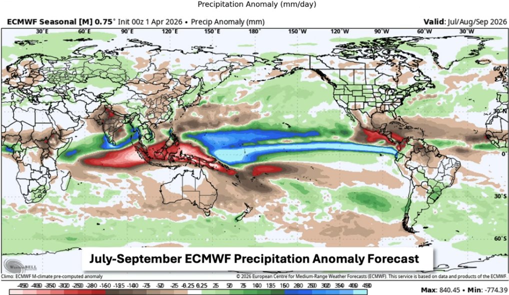
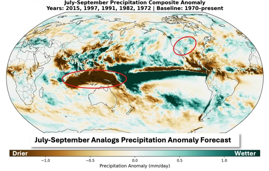
Euro vs EL nino climo. I think slightly below normal starting in May is a good bet. Which honestly isn't the worst outcome to keep the drought from accelerating.

-
Not sure what you’re seeing but it looks like normal temp pattern with many sunny dry days of 60’s. Sure a day like Monday will happen but will be the exception . Looks like anything but ass
-
76/62 Beautiful out
-
Oh look. Another mid summer day. This july hasn't been horrible but it hasn't been great. I can't wait for just slightly above average to return lol
- Today
-

2026-2027 El Nino
michsnowfreak replied to Stormchaserchuck1's topic in Weather Forecasting and Discussion
That is one funky looking standout of blue. Jokes aside, I know you know it, but remember its all relative. The coldest winter ever recorded in Anniston, AL is warmer than the warmest winter ever recorded here. I feel like when we are so far out from the next winter, its easy to focus too much on temps. -
We aren't going to stay dry forever. This notion that we are the desert SW all of a sudden is hilarious.
-
Nice day with cumulus
-
Maybe I'm squinting at it too hard but it looks like the passage of the evening QLCS is bumping earlier instead of later, which I'd love to see it with even half a lux of sunlight left. Also: .UPDATE... Issued at 1015 AM CDT Fri Apr 17 2026 There is a trailing boundary extending south from ongoing convection across the Minneapolis area. This boundary may be an initial source for forcing as it spreads towards northern Illinois in the mid afternoon time frame. The airmass is still stable per the extensive area of billow clouds across Iowa, however we have noted a significant uptick in the dewpoints out ahead of this feature. Instability progs would suggest by the time this boundary arrives northern Illinois should destabilize, and thus there at least some concerns for a leading round of convection, which could be in the form of supercells with an all hazard threat. Some questions still exists as to whether this will just graze the local area or continue to push closer to the Chicago metro area. There is a shortwave across Missouri that also slide through the area ahead of the cold front which could be a mechanism to keep convection farther east, so this will be a mesoanalysis focus in the coming hours. Limiting factors for this first round convection having a larger footprint would be that the forcing is a bit more subtle, and we still have a fairly deep dry layer ahead of this boundary. Regardless of this, low level flow will reintensify ahead of the cold front which should help to keep instability up into the evening hours, where a damaging wind threat would be the highest concern, along with a QLCS tornado threat. Thoughts from the morning AFD still tell the story quite well. KMD
-
I stand by it that low 60s dews in April is humid. Imperial (Metric) Date Time (edt) Wind (mph) Vis. (mi.) Weather Sky Cond. Temperature (ºF) Relative Humidity Wind Chill (°F) Heat Index (°F) Pressure Precipitation (in) Air Dwpt 6 hour altimeter (in) sea level (mb) 1 hr 3 hr 6 hr Max. Min. 17 11:53 N 6 10.00 Fair CLR 75.9 57 52% 78 29.84 1010.5 17 10:53 S 3 10.00 Mostly Cloudy BKN035 73.9 60.1 62% 29.84 1010.5 17 09:53 Calm 10.00 Mostly Cloudy SCT042 BKN060 72 61 68% 29.85 1010.6 17 08:53 Calm 10.00 A Few Clouds FEW043 70 61 73% 29.84 1010.3 17 07:53 N 3 10.00 Mostly Cloudy BKN110 66 61 66 57 84% 29.83 1010.0
-
It's humid, just go with it.
- 605 replies
-
- 1
-

-
- april showers bring may..
- rain
- (and 2 more)


.thumb.gif.f92b16c631a1d15d405ed77b33f0710d.gif)