All Activity
- Past hour
-
The last true DC-PHL-NYC-BOS corridor KU snowstorms were back in February, 2021. It shutdown at the end of that month, never to be heard from again
-
Sort of, def major for sure
-
Funny because only 5 miles SE of there 2 winters ago I got 6.5” of snow
-
I’m dying. Heeeerrrrreee’s Davy!!
-
25th straight top 10 day in a row
-
crazy nice out
-
putting in that
-
Today's best forecast goes to AccuWeather for my zone calling for increasing clouds in the afternoon versus the national weather service with totally sunny conditions. Clouds have moved in currently in the from Trenton to Philly to Wilmington, Delaware. Moving from Northeast to Southwest.
-
75/50 Lawn mowed. Prep for open house tomorrow. Awesome GSD day.
-
hey guys about 90 days until we snow
-

Occasional Thoughts on Climate Change
donsutherland1 replied to donsutherland1's topic in Climate Change
The literature is still mixed on the magnitude of its impact. Hopefully, the literature showing more than a minimal impact will ultimately be vindicated. If not, there will be the issue of whether one or more unidentified factors drove the spike. In turn, that would raise questions about whether there are things that are being missed in the climate models, factors that could potentially lead to higher sensitivity. Already, the "hot models" hypothesis has largely been settled. Those models likely have the better handle on climate sensitivity, as their cloud physics have better matched the developments that have now been observed and their scenarios are closer to the paleoclimate data for some past warming events that saw greater climate sensitivity. -
Lantern flies. Scroll up to see a video post from @astarck.
- Today
-
Totally different from the Euro for NNE.
-
-
for me the highest storm in 2014 was the overpreforming vday storm with ~19" here, 20-26" in the ridges north of me
-
i want to believe would take what the nest is selling obv
-
Ok I just looked. What is all of that showing up?
-
We've potentially reached the extent minimum on Jaxa (4.55 mil sq km on 9/8). We're about 50k above that now. We'll see if there are enough drops in the coming week to offset gains. If we have indeed reached the extent minimum, it would rank 14th lowest. Area is even murkier...we're only about 10k above the min of 2.70 million sq km. We're currently 5th lowest for area. We'd need to drop below 2.63 million sq km to reach 4th lowest.
-
UKMET (12Z) again has the lemon as a TS in the MDR. It develops it 18 hours later. Unlike last run, this one has it already recurving out of the MDR way out in the middle of nowhere: NEW TROPICAL CYCLONE FORECAST TO DEVELOP AFTER 120 HOURS FORECAST POSITION AT T+120 : 18.5N 45.0W LEAD CENTRAL MAXIMUM WIND VERIFYING TIME TIME POSITION PRESSURE (MB) SPEED (KNOTS) -------------- ---- -------- ------------- ------------- 1200UTC 17.09.2025 120 18.5N 45.0W 1006 39 0000UTC 18.09.2025 132 19.9N 46.2W 1006 39 1200UTC 18.09.2025 144 22.6N 48.3W 1006 43 0000UTC 19.09.2025 156 24.3N 50.8W 1006 36 1200UTC 19.09.2025 168 25.2N 52.2W 1005 41 ————- Also, this run doesn’t have the 2nd TC that the prior run had.
-
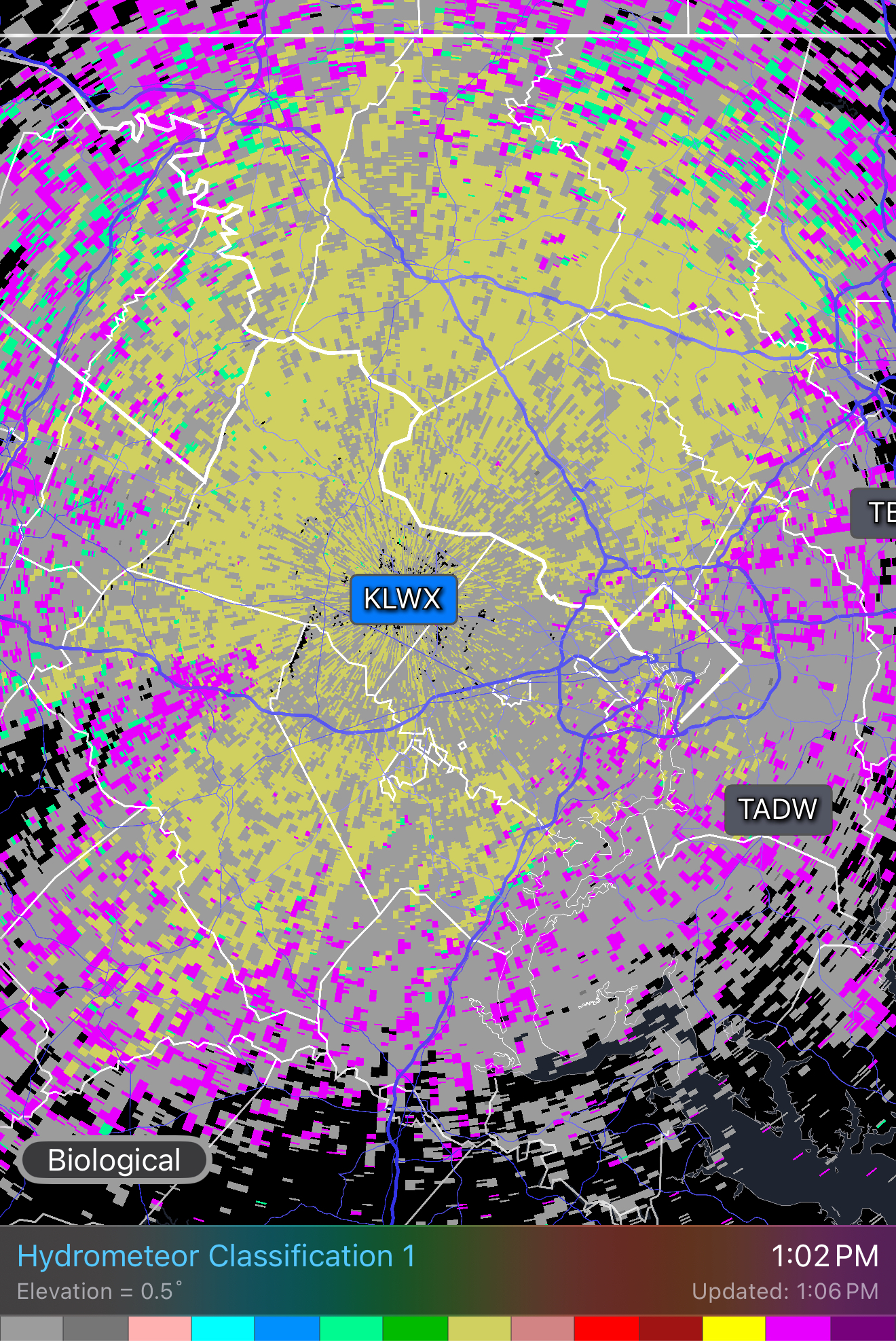
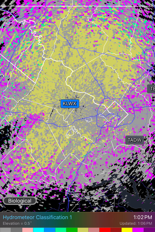
The radar algorithm is nicely split between biological scatterers and large hail.
-
70/51. Doesn't get much better.
-
And JB has been talking like there’s been significant cooling that he attributes to reduced undersea seismic activity. But in this case (Sept 1-10) it’s ~0.2C cooler than 2 years that were a whopping 0.4 warmer than the prior year. Imagine how 2025 would stick out like a warm thumb had 2023 and 2024 not been on the graph! Edit: Aside: I still have to wonder why there was that 0.4C spike up and whether or not that undersea volcanic explosion bringing tons of H2O into the atmosphere had something to do with it. It’s awfully coincidental timing!
-

September 2025 OBS-Discussion centered NYC subforum
Stormlover74 replied to wdrag's topic in New York City Metro
Been pretty cloudy here all morning -

2025 Lawns & Gardens Thread. Making Lawns Great Again
SJonesWX replied to Damage In Tolland's topic in New England
that's called the "fuck you" grass. as in: fuck you, we can grow where you don't want us to, but can't grow where you need us. -

September 2025 OBS-Discussion centered NYC subforum
SACRUS replied to wdrag's topic in New York City Metro
Up to 76 but an area of clouds rolling through now more sunny