All Activity
- Past hour
-
went from 62 to 37 in 1.5 hours
-

Central PA Spring 2026 Discussion/Obs Thread
canderson replied to Voyager's topic in Upstate New York/Pennsylvania
Funny, my parents are currently in the storm shelter because a tornado warning there (in E Texas). -
Looks to me like it’s going to develop one helluva back end defo band in the cold conveyor
-
Yeah it’s been windier in the foothills than usual for sure. I lost 3 large and mature trees in December, and a couple of weeks later I lost a portion of fencing. Looking forward to eventual calm weather.
-
Pull off the road and stop. You can’t drive in that. It’s worse than a blizzard vis wise
-
 Nam 3k Says why are schools closing
 -
Ready to thunder pinger
-
On radar this thing looks like it’s falling apart or having a huge dry slot coming in. Am I wrong ? Being honest ?
-
 I probably have at least 50 trees that could reach my house but luckily the only close call(other than some branches) was an oak that fell during Irene. The very top branches barely brushed the back of the house.
 -
We go from heavy squalls to heavy snow in just hours. Flow snow continues to look stout Sent from my SM-G998U using Tapatalk
.thumb.jpg.5f3858856c7b2d5f32abb450600f9646.jpg)
.thumb.jpg.cbb0518e255e2558c3f12053cf06aca4.jpg)
.thumb.jpg.cec7d30f09d83e2f3b52d5414bb947e3.jpg)
.thumb.jpg.28e4882faba37c11f28dd3a972595ebd.jpg)
.thumb.jpg.ac0ab58c02d9ea84195cec99222989cc.jpg)
-
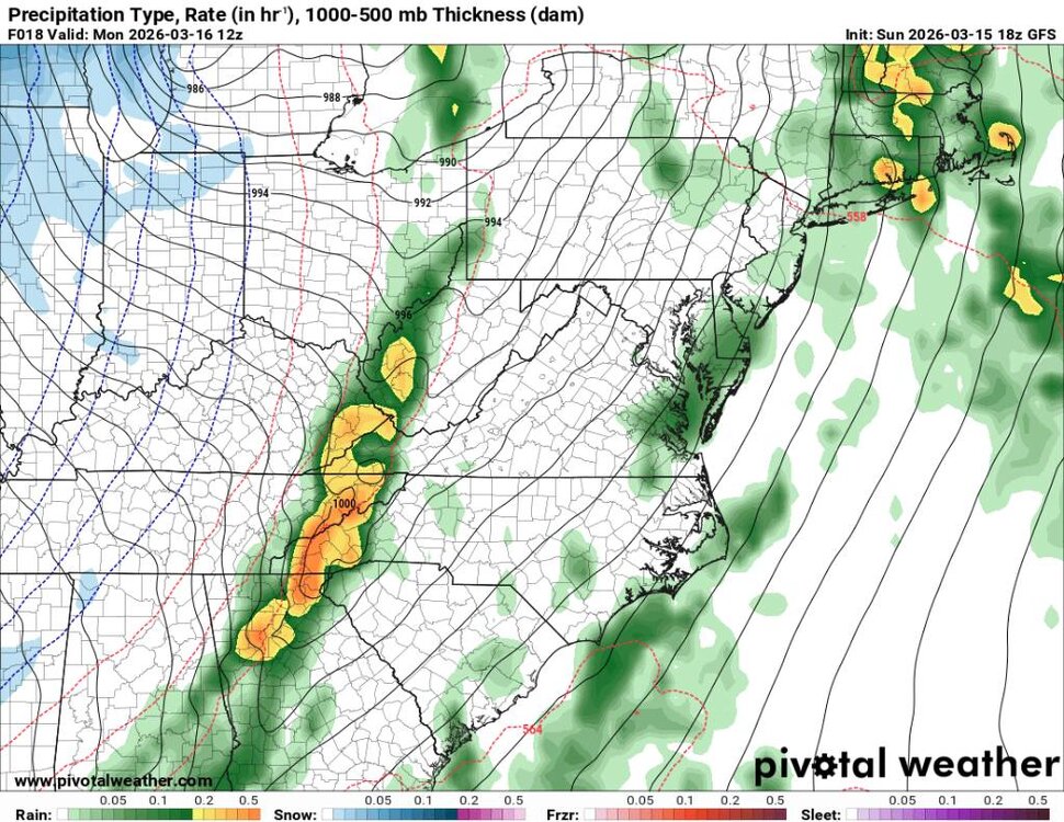
Although we’re basically in nowcast territory, here’s the newest GFS:

-
Morning rush hour traffic will be hairy in the morning. Expect wrecks on the interstate... Sent from my SM-G998U using Tapatalk
.thumb.jpg.55cd9ab576ad66ef5bbd6974bf4e8d08.jpg)
-
Going to be us tomorrow.
-
 Where’s @bnchoOnly a snow beast, but no interest in severe!? Come on dude. It’s good to be well rounded! And yes—this is how I have envisioned you to look like all winter.
- 136 replies
-
- 1
-

-
- severe
- thunderstorms
- (and 1 more)
-
 Washington County MD schools closing 2 hours early tomorrow
 -
75° and breezy here. Very nice spring day. Did just have a gust hit 56 mph though
-

Spring 2026 Pattern Discussion Thread
Carvers Gap replied to Carvers Gap's topic in Tennessee Valley
Taste the rainbow... -

Central PA Spring 2026 Discussion/Obs Thread
WmsptWx replied to Voyager's topic in Upstate New York/Pennsylvania
There needs to be consequences for this kind of lunacy. Their social media accounts should be permanently suspended and a ban on any new accounts with the same or similar language instituted. -

2025-2026 Fall/Winter Mountain Thread
Buckethead replied to Buckethead's topic in Southeastern States
Tornado and snow squall warnings about 150 miles apart currently in Missouri. Sent from my Pixel 10 Pro using Tapatalk -
Central PA Spring 2026 Discussion/Obs Thread
canderson replied to Voyager's topic in Upstate New York/Pennsylvania
Didn’t want to clutter the other thread. Thank you for that tremendous write up. It was fantastic. Tomorrow will be rough down your way. -
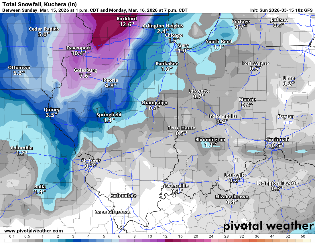
Yep we had a solid 2 hours of dendrites coming down nicely and they barely added to the total and the car outside was just wet. Gonna call it 11.5” here storm total but hard to be exact with the drifting
-

Central PA Spring 2026 Discussion/Obs Thread
MAG5035 replied to Voyager's topic in Upstate New York/Pennsylvania
Count me in on this thinking as well, in PA at least. Certainly dynamics look very favorable in terms of shear/helicity, along with very high low level winds to tap down. Whether or not south-central/Sus Valley cracks all the way into the warm sector ahead of the front to take fuller advantage of those dynamics seems to be a main potential limiting factor. 18z 3k NAM never really builds much CAPE in the Sus Valley (cloud cover), having a narrow corridor of modest CAPE further west in the south-central counties. Newest high res model runs doesn’t look particularly organized with any kind of solid QLCS line, which would be the primary threat here over discrete cells… though I wouldn’t rule those out completely, esp with any breaks to help with daytime heating. As a side note the 18z 3k NAM was a prolific snow maker behind the front in western/central PA and other high res like the HRRR has at least a couple inches mainly in the Laurels/north-central. As another side note, this is occurring tomorrow literally one year to the date last year that we had a QLCS type line come through mainly the western and central part of the state with many tornado warnings and an 89mph wind gust at Latrobe. -
 Hoco schools sent an email and text to say they're monitoring
 -

E PA/NJ/DE Spring 2026 Obs/Discussion
Albedoman replied to PhiEaglesfan712's topic in Philadelphia Region
Yes I agree, the clody maritime SE fetch is going to destroy the instability factor east of the Blue Mts. No sunshine = no severe weather. The race is on if the sun comes out before the storms hit our area. I see a duration of light to moderate rain until late in the afternoon as the best bet. Rumbles of thunder and heavier downpours tomorrow evening with squallywinds at frontal passage . Anyone west of York/Lancaster, watchout. Tornado watches west of Berks county a good bet -
 I agree. Never seen that happen ...but I'm from a different time . Hell I graduated in 1985 ! I'm olddddddd
- 136 replies
-
- 1
-
-
- severe
- thunderstorms
- (and 1 more)


.thumb.png.e28622a101ead8a503efd5015c7d3862.png)

.jpg.e4c591049c292385daf9a59bee2cc01a.jpg)
.jpg.2fac0ef2379eb99ec6f0b2ff6913a58e.jpg)
.jpg.fb9eddfc1d5467090a9899771ed62fa0.jpg)
.jpg.f45523206689a0ffa888b1a0225c395a.jpg)
.jpg.74d1637662982559c1a0e50b1f902aa2.jpg)


.jpg.0b872db003b4a6954cf0e7b441607704.jpg)


