All Activity
- Past hour
-

September 2025 OBS-Discussion centered NYC subforum
doncat replied to wdrag's topic in New York City Metro
Astro summer rain here of 8.34" was 4th lowest in 45 years of record. -

September 2025 OBS-Discussion centered NYC subforum
SACRUS replied to wdrag's topic in New York City Metro
68 / 56 partly cloudy onshore easterly flow. Warmer tomorrow / Tue low / mid 80s Tuesday then cutoff barrage Wed - Sun and perhaps the cloudiest and wettest period in a while. Beyond there near normal. -
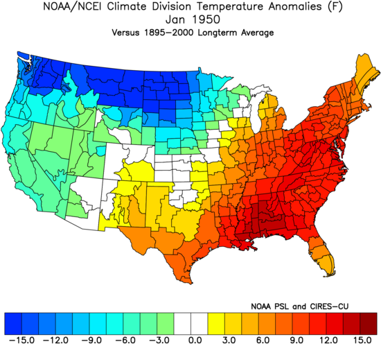
January 1950 still stands as the warmest on record in Atlanta following the lower 96 ACE that season. Time Series Summary for Atlanta Area, GA (ThreadEx) - Month of Jan Click column heading to sort ascending, click again to sort descending. 1 1950 55.4 0 2 1880 54.3 0 3 1974 53.2 0 4 1937 53.0 0 5 1907 52.2 2 6 2017 52.0 0 7 1949 51.8 0 8 2023 51.7 0 9 1932 51.2 0 10 1890 51.0 0
-

September 2025 OBS-Discussion centered NYC subforum
wdrag replied to wdrag's topic in New York City Metro
No thread atom--maybe something late Monday???: need more ensemble support but looking at widespread 1-3 rainfall totals Tuesday afternoon-next Sunday with iso 5+ POSSIBLE. Depends on evolution and track of developing UA low Ohio Valley middle and end of next week... ie stall the showery late Tuesday surface CFP just to our south Wed-Sunday with weak waves of low pressure. LONG Ways off but am not too alarmed by the recent dryness... happens and then a blast of rain. We do need that OH Valley LOW to form and eject across NJ next Sunday as it finally weakens. Otherwise wait til October. -
Neat old documentary (1978) about the 1938 hurricane https://youtu.be/cCMoqMujLh4?si=dlderiR9ma4UBqPG
-
How things have changed…
-
BOS -1.5F MTD ORH is 0.0.
-
So that was an arctic airmass and basically ideal radiating conditions. If you didn’t get to frost it’s not in your climo anymore for the date…
-
there is insulation under the roof so it radiates better than the glass
-
Gabby on its way to becoming our next hurricane
-

2025-2026 ENSO
PhiEaglesfan712 replied to 40/70 Benchmark's topic in Weather Forecasting and Discussion
I like 1949-50 as an analog better than 1950-51. (By the way, those years still hold the record for the least snowy 2-year period at PHL.) 50-51 was a very active Atlantic hurricane season. By my calculation, it is the 5th highest ACE season at 227.1413 (Wunderground has it as the 2nd highest at 243). We don't have anywhere near that this year. November 1950 was month of weird extremes. In some places in the east, you had high temperatures in the 80s (at the beginning of the month), and by the 25th, you had low temperatures near 0. -
 Desperate times…
 -
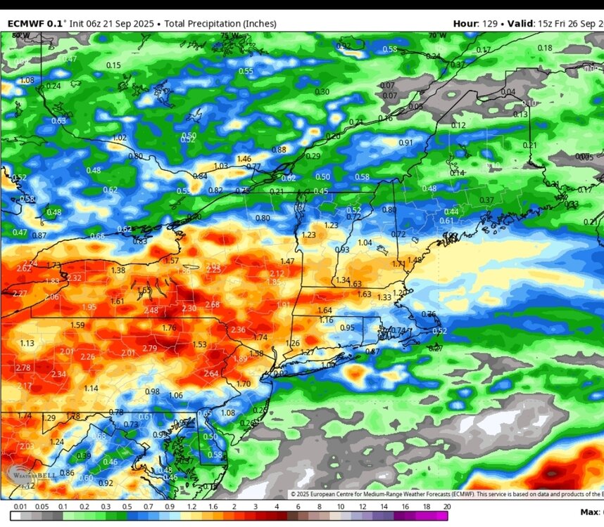
In general looks like a wagons north for showers this week. The area that needs it most looks to be bullseye
- Today
-
 super typhoon Ragasa is rated at 140 kt (Category 5) by JTWC and near the Philippines/Taiwan
 -
Got down to 38.5° here. Forgot to close the bathroom window, so it was a little chilly when I woke up this morning. Lol
-
I don’t think we are going to see a big October burst in Atlantic tropical activity. This is how many months in a row now that people have been saying a big burst is coming? The finish line just keeps getting moved further and further forward in time. Now it’s October. This is becoming The Boy Who Cried Wolf. Eventually you have to acquiescence and admit defeat
-
People talking about end of growing season, while I just picked up last round of reseed and fertilizer.
-
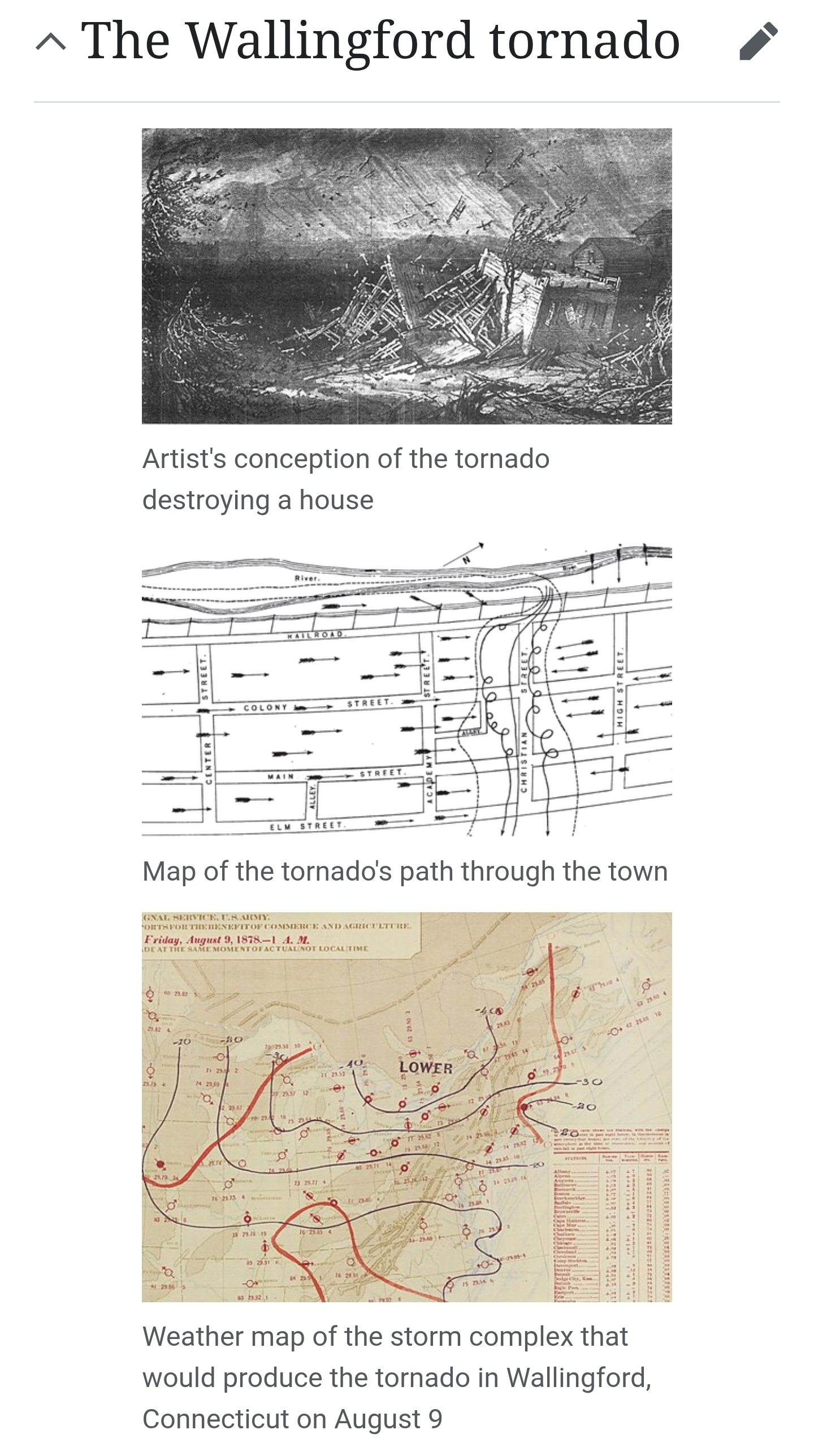
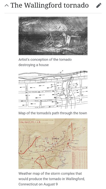
Nothing compared to tornadoes of yore like Wallingford in 1878. The tornado started at 6:15 p.m. local time[1] as a waterspout over Community Lake, just west of town. It then moved through the center of town along Christian Street, damaging almost every structure as it went. The tornado tore houses from their foundations, throwing some more than 600 feet (180 meters). A receipt from the town was later found 65 miles (105 km) east in Peacedale, Rhode Island.[4] Large trees were uprooted and snapped, and those that were still standing were stripped of small limbs and leaves. The Catholic Church was blown to bits, and heavy tombstones in the nearby cemetery were tossed around. The brand-new brick high school building was almost completely destroyed.[6] The tornado's path through town was only two miles long, but the damage path was up to 600 feet (180 meters) wide.[7]
-
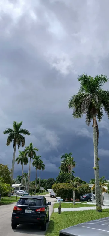
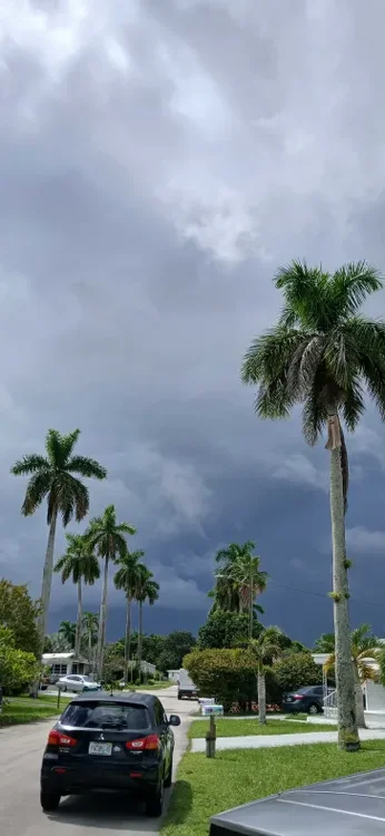
This picture doesn't do it justice how dark this cloud really was. moisture laden storm cloud as i visited family.
-
Stupid rain. I knew it was going to happen someday.
-
What do you and others think about the Nov 1950-March 1951 weak La Ninaish ENSO before warming up late as an analogue for 2025-6? A well-known met. got on that train yesterday due to an anticipated active late tropical season having the potential to be similar to Oct of 1950 based on precip anomaly progs by the longer term Euro. This met. talked about the severe effects on the NE US caused by the 11/25/1950 superstorm.
-
Similar temperatures to yesterday across the area with temperatures warming by Tuesday to well into the 70's to near 80 degrees. We then turn cooler for the rest of the week. The good news is our chances of rain are starting to increase by late Tuesday, and showers will be in the forecast for most of the rest of the week. Most models paint between 0.50" to 1.25" across the area. Let's hope this comes to pass.
-
(002).thumb.png.6e3d9d46bca5fe41aab7a74871dd8af8.png)
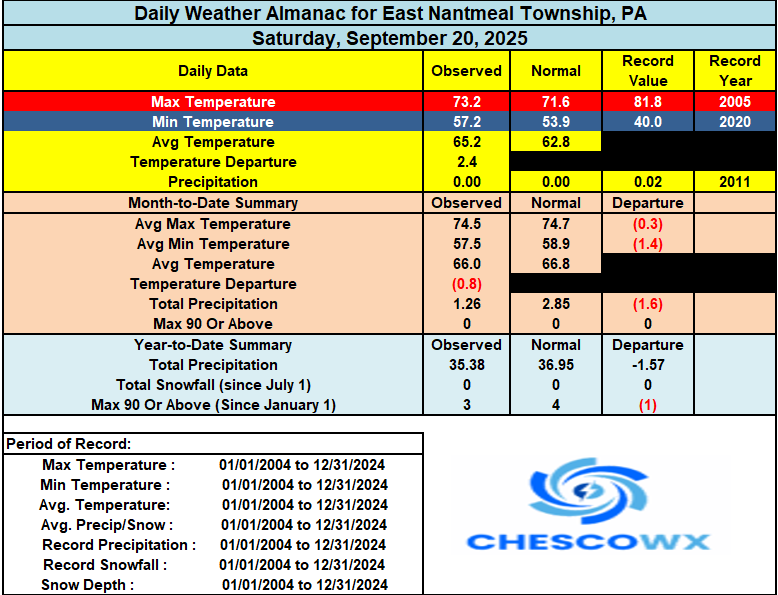
E PA/NJ/DE Autumn 2025 Obs/Discussion
ChescoWx replied to PhiEaglesfan712's topic in Philadelphia Region
Similar temperatures to yesterday across the area with temperatures warming by Tuesday to well into the 70's to near 80 degrees. We then turn cooler for the rest of the week. The good news is our chances of rain are starting to increase by late Tuesday, and showers will be in the forecast for most of the rest of the week. Most models paint between 0.50" to 1.25" across the area. Let's hope this comes to pass.
-

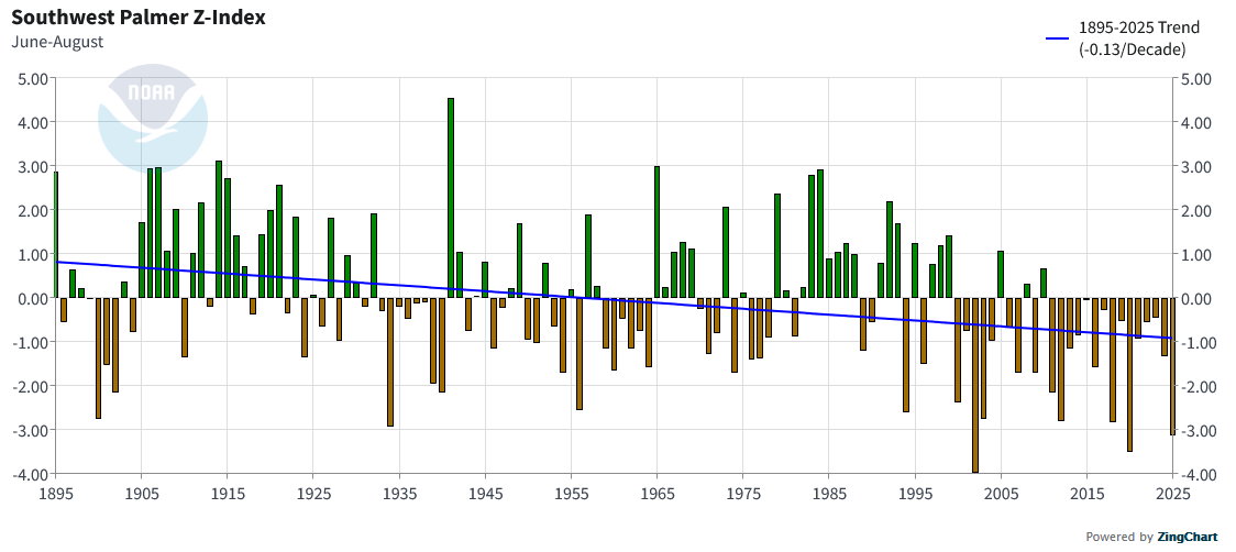
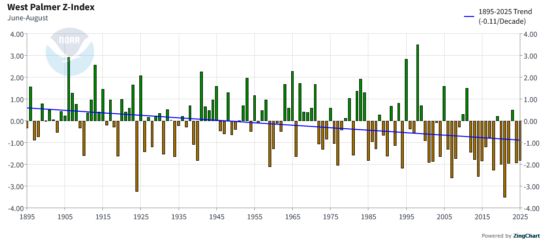
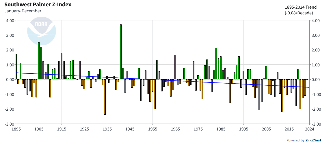
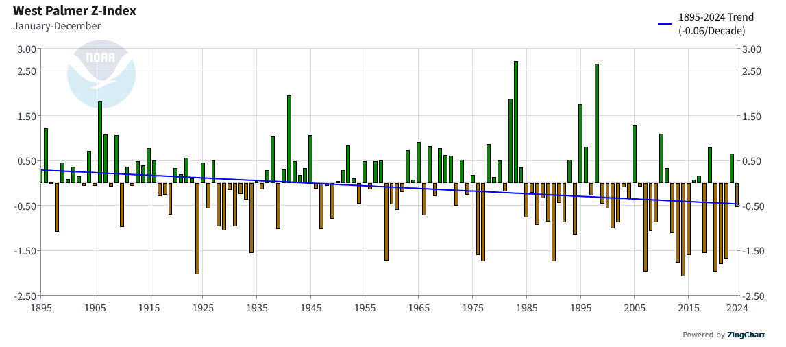
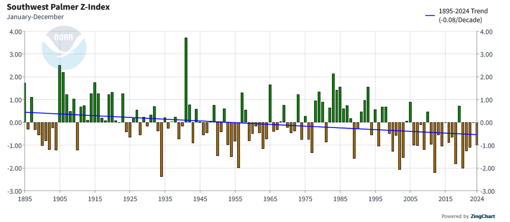
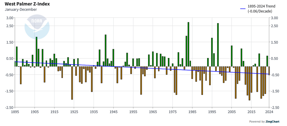
Occasional Thoughts on Climate Change
donsutherland1 replied to donsutherland1's topic in Climate Change
The heat in the West and Southwest are aided by ongoing aridification linked in recent research to the changes in the North Pacific. Summer: Annual:

-
We’ve known for years you are one of the longest growing seasons in New England. Just amazing how hard it is to drop there.


.thumb.png.4150b06c63a21f61052e47a612bf1818.png)