All Activity
- Past hour
-
No, we don't.
-
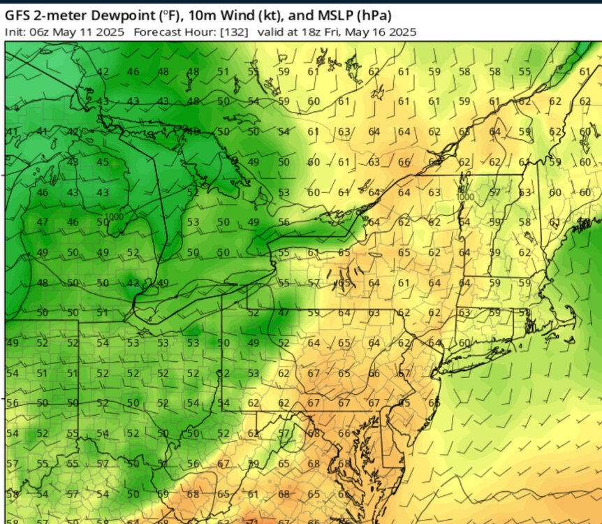
Going to be very difficult dealing with upper 50's to low 60's dew points...likely going to wipe out part of the population...
-
Why did you even install if you like all the ass sweat of summer..?
-
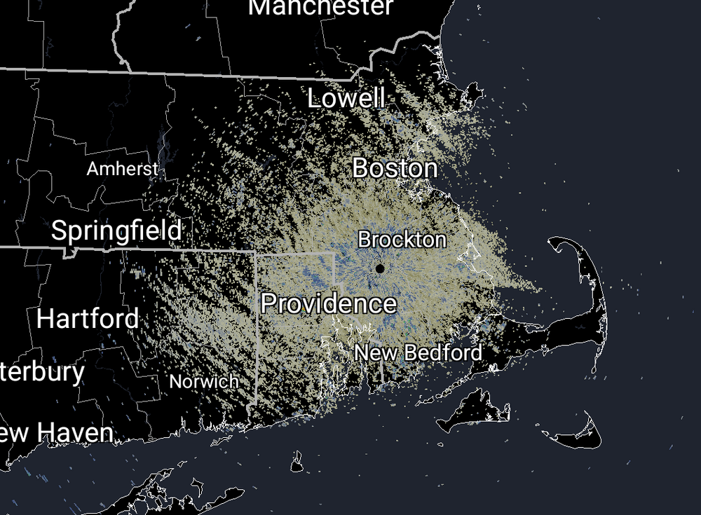
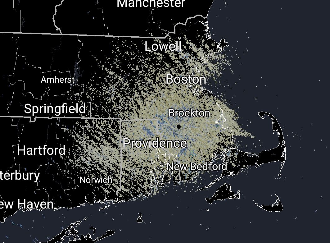
what's being picked up on radar?
-
Stifling.
-
People on the east side of the Potomac are going to truly hate the morning hi-res runs.
-

Central PA Spring 2025
Itstrainingtime replied to canderson's topic in Upstate New York/Pennsylvania
WPC actually lowered rain amounts for the upcoming week - 1.5" grazes the southern tier. Less north through PA. -
Central PA Spring 2025
Itstrainingtime replied to canderson's topic in Upstate New York/Pennsylvania
76.2 here at 11:30. 80 looks quite possible. -
No thread yet... if ever, but MLB games in Cleveland, Atlanta, Philly, NY I expect will see delays or cancels into D-N double headers this coming Monday-Thursday, possibly Fri and the weekend. Most of the delays-cancels should be Tue-Wed, as a start for my own expectations. I apologize if this duplicates someone else's post. Trends for the axis max rainfall may shift north as it has been the past couple of days.
-
If MJO812 comes with I’ll bring the tools and do the trimming!!!!
-
Glad that huge chore is over and have used on several occasions With the dews coming later this week, any remaining few that have not installed will be sweaty and agitated putting them in
-

E PA/NJ/DE Spring 2025 Obs/Discussion
JTA66 replied to PhiEaglesfan712's topic in Philadelphia Region
Came to post some obs but apparently found myself in the So Cal forum -
When you look at the regional increase in 90 days, NYC is the only outlier. LGA has seen a slower increase in 90° days than New Brunswick which is in a more rural to suburban type setting with grass and nearby trees. The base period that I am using for comparison is 1961-1990. This is the base period many of us grew up in before the summers and other seasons began to rapidly warm. So it was the last time we had anything approximating a stable climate. Summer warming especially accelerated from 2010 to 2024. 12 out of those 15 summers were above normal warmth to record warmth across the area. We only had 3 summers near to slightly below average temperatures in 2014, 2017, and 2023. The last time we had an actual cool summer was back in 2009. NYC has only seen an increase of 5.5% in the number of 90° days. Newark is at a 43.5% increase. LGA has increased 78.5%. New Brunswick has jumped 93.7%. POU to our north has seen a 50% increase. So NYC is the obvious outlier. LGA has been subject to cooling breezes off the water in recent summers since the ASOS is right on the water. There have been several more 90° days to the south closer to Corona, Queens. Newark has also had several summers recently with more onshore flow. This is why areas to the west have seen more 90° days. If the NYC ASOS wasn’t moved into the shade back in 1995, then the average would be at around 29 days reaching a year now vs 19. So this does a big disservice to residents living in Manhattan where the number of 90° days has been getting undercounted. I arrived at 29 days since this represents around a 60% increase when the Newark and LGA rate of increase is averaged out. So this is what the actual NYC annual number of 90° days would be closer to if the measurements were taken in a clearing like the Great Lawn rather than in a dense area of vegetation under a tall stand of cool shade trees. 1961 -1990 to 2010-2024 change in 90° days NYC….18 to 19……..+5.5% EWR….23 to 33……..+43.5% LGA…..14 to 25……..+78.5% NBW….16 to 31……..+93.7%…….My abbreviation for New Brunswick POU…..14 to 21……..+50%
-
we can get @MJO812 to look the other way
-
No significant signs of the 90 degree mark arriving any time soon to our area. Early indications show Memorial Day weekend almost averge temps.
-
Hopefully, not two busted forecasts in a row.
- Today
-
How are the installs going for you?????.....
-
August of 2013 was cooler and wet. it did have the massive Western Atlantic Ridge expansion and linking with the rockies ridge in July for the massive heat dome but 2018,2019, 2022 all warmer/hotter for sustained periods
-
That was the summer west of the Hudson had many more 90 degree days. Many spots in NJ exceeded EWR numbers, ---------------------------------------------------------------- 2022: PHL: 47 (Apr: 0 ; May: 3 ; Jun: 5; Jul: 19 ; Aug: 18 ; Sep: 2) EWR: 49 (Apr: 0 ; May: 4 ; Jun 6 ; Jul: 20; Aug: 18; Sep: 1) TTN: 31 (Apr: 0 ; May: 2 ; Jun: 1 ; Jul: 14 ; Aug: 14; Sep: 0) LGA: 30 (Apr: 0 ; May: 3 ; Jun: 3; Jul : 11; Aug: 13; Sep:0 ) ACY: 33 (Apr: 0 ; May: 2 ; Jun: 3 ; Jul: 16; Aug: 12; Sep: 0 ) TEB: 35 (Apr: 0 ; May: 3 ; Jun : 3 ; Jul: 13 ; Aug: 16; Sep: 0 ) NYC: 25 (Apr: 0 ; May: 2 ; Jun:1 ; Jul: 10 ; Aug: 11; Sep: 1 ) JFK: 16 (Apr: 0 ; May: 1 ; Jun: 1; Jul: 9 ; Aug: 5 ; Sep: 0 ) ISP: 13 (Apr: 0 ; May: 2 ; Jun: 1 ; Jul: 5 ; Aug: 5; Sep:0 ) New Brunswick: 42 (Apr: 0 ; May: 3 ; Jun: 3; Jul: 17; Aug: 18; Sep: 1 ) BLM: 28 (Apr: 0; May: 4 ; Jun: 2 ; Jul: 12 ; Aug: 10) 89 Degree Days: NYC: 5 TEB: 3 PHL: 4 New Brsnswk: 4 ACY: 3 JFK: 7 LGA: 3 TTN: 7 BLM: 5 EWR: 3 ISP: 7
-

Spring 2025 Medium/Long Range Discussion
cyclone77 replied to Chicago Storm's topic in Lakes/Ohio Valley
Looks like another miss for this area. This time to the east. -
Next 7 days
-
Records: Highs: EWR: 93 (1993) NYC: 92 (1993) LGA: 96 (1953) JFK: 85 (1993) Lows: EWR: 36 (1966) NYC: 36 (1966) LGA: 42 (1945) JFK: 40 (1966) Historical: 1865: A tornado touched down in Philadelphia around 6 PM ET, killing one person and injuring 15 others. There was a considerable destruction of property, with 23 houses blown down, damage to the Reading Railroad depot, with the water tank, carried 150 yards. Fairmont Park was damaged to the amount of $20,000. 1934: A tremendous dust storm affected the Plains as the Dust Bowl era was in full swing. According to The New York Times, dust "lodged itself in the eyes and throats of weeping and coughing New Yorkers," and even ships some 300 miles offshore sawdust collect on their decks. 1945: On May 10th and 11th 10.0 inches or more of snow fell over interior Massachusetts and the lowest barometric pressure for the month of May was recorded at 29.09 inches of mercury. 1951: Baltimore, MD recorded their latest snowfall on record with a trace. 1953 - A tornado hit Waco, TX, killing 114 persons and burying some downtown streets under five feet of fallen bricks. (The Weather Channel) 1966 - The 1.6 inch snow at Chicago, IL, was their latest measurable snow of record. Previously the record was 3.7 inches on the 1st and 2nd of May set in 1940. (The Weather Channel) 1970 - A very powerful tornado struck the city of Lubbock, TX, killing 26 persons, injuring more than 500 others, and causing 135 million dollars damage. It was the most destructive tornado of record up until that time, and came on the 17th anniversary of the twister which struck Waco TX killing 114 persons. A second tornado killed two others persons in Lubbock, and the two tornadoes damaged or destroyed nearly a quarter of the city. (David Ludlum) (The Weather Channel) 1987 - Early morning thunderstorms produced up to four inches of rain in southern Texas, with flooding reported from Maverick County to Eagle Pass. Evening thunderstorms in northern Illinois produced golf ball size hail and wind gusts to 70 mph. (Storm Data) (The National Weather Summary) 1988 - Unseasonably warm weather prevailed in the southwestern U.S. Reno, NV, reported a record high of 89 degrees. (The National Weather Summary) 1989 - Afternoon and evening thunderstorms produced severe weather in the High Plains Region. Thunderstorm winds gusted to 71 mph at Gillette WY, and baseball size hail was reported at Pecos TX and Fort Stockton TX. Fort Stockton TX was deluged with 7.75 inches of rain in less than two hours. (The National Weather Summary) (Storm Data) 1990 - Unseasonably cold weather followed in the wake of a spring storm in the north central U.S. Seven cities reported record low temperatures for the date, including Madison WI with a reading of 29 degrees. Thunderstorms produced severe weather in Kansas, Oklahoma and the northern half of Texas. Severe thunderstorms spawned four tornadoes in Texas, and produced high winds which overturned four mobile homes northwest of Abilene TX injuring ten persons. (The National Weather Summary) (Storm Data) 2005 - Strong thunderstorms affected parts of the U.S. Great Plains. In the Hastings, Nebraska area, significant severe weather occurred, including very large hail, damaging winds and widespread flooding. Radar estimated rainfall accumulation locally exceeded 10 inches.
-
They don't have to tell anybody. Perhaps a group of us can go in there, with a ladder, with nobody suspecting anything?
-
It's NYC.
-
73 / 40 another beaut! today. Approaching or low 80s in the warm spots. Tomorrow a touch cooler with the clouds pushing in but still mid / upper 70s. Tue - Fri - cut off and unsettled with 1 - 2 inches in the forecast through May 16th. Beyond there timing looks to clear out by the weekend 17/18. Beyond mid month near normal - no sustained significant warmup or cool. Still think the progression get us much warmer to hot for a period in the final 10 days, other wise riding near normal overall.


.thumb.png.4150b06c63a21f61052e47a612bf1818.png)


