All Activity
- Past hour
-
Nice. I'll probably be sweating a little this far south in Geauga county.
-
Happy Thanksgiving!
-
The only fly in the ointment this morning is the MJO. It still gets to 8, but not until we have an obnoxious loop through 7 and it heads for the COD at the timeframe I was hoping it would steer into 1.
-

E PA/NJ/DE Autumn 2025 Obs/Discussion
Mikeymac5306 replied to PhiEaglesfan712's topic in Philadelphia Region
I think the 6Z got into the Thanksgiving cheer a little early. Wave after wave after wave. -

Nov 28-30th Post Turkey Day Wintry Potential
Stevo6899 replied to Chicago Storm's topic in Lakes/Ohio Valley
I feel like you could've omitted the first half of that first sentence lol but i see you, letting everyone know who the leader is. -
lol you get fired up easily. Nobody is trying to give you shit. Just relax.
-

Nov 28-30th Post Turkey Day Wintry Potential
jlauderdal replied to Chicago Storm's topic in Lakes/Ohio Valley
I arrive Friday afternoon, moved it up a day. Saturday morning 6 am-the flakes better be flying and the green grass disappearing. IKK can keep the freeze line there, no further north please. EURO-AI is troubling into sunday morning. -
Don’t hate this look at range
-
Please keep talking dirty to me.
-
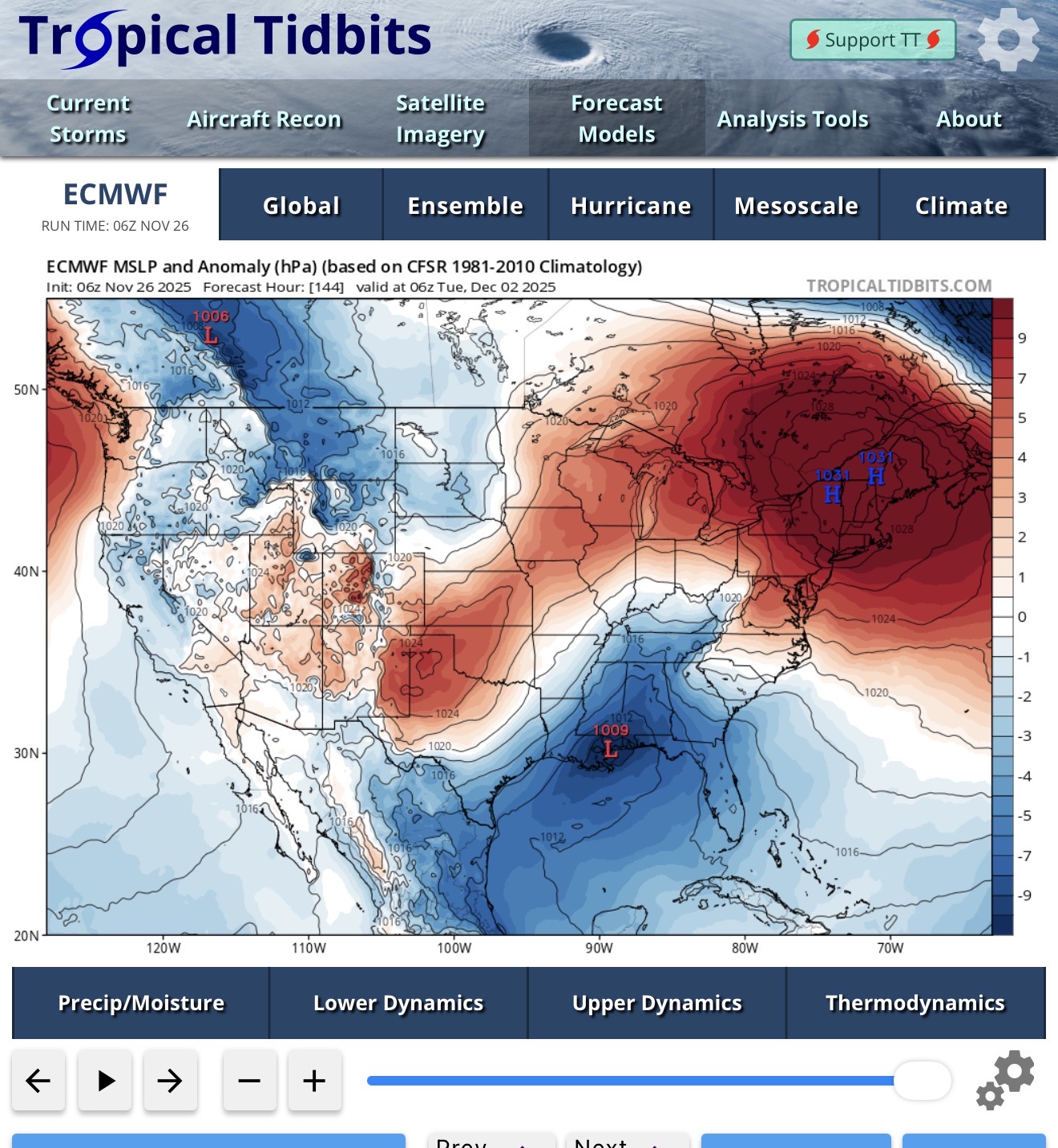
This type of miller A evolution is probably decent for us if it holds like that. It’s kind of a slower developing system so it’s not like you are going to see it blowing it’s wad down in VA or the Carolinas. Trough stays positively tilted for a while which prevents occlusion too early. This is why I previously mentioned that it’s probably a good thing that the southern stream drags a little. If it didn’t, we’d rip this like due north into BGM or ALB or something.
-
I'll say this....This is actually a pretty classic way for this area to get on the board for the season. Waving timing and thermal gradient positioning will be the keys unless something else sneaks up to affect the pattern. Not too complicated, but still a tight rope walk in a way. Inside 7 days. We're keeping an eye on it here at the National Center.
-

December 2025 regional war/obs/disco thread
wokeupthisam replied to Torch Tiger's topic in New England
The bolded is what I'm most hoping for. Early Dec snow threat tracking is fun and while reading the daily ups/downs in here, I'm always keeping one eye on that Christmas -New Year timeframe. This despite the evil grinch poking a sharp stick in that watchful eye most years, but every year I fall for it again like Charlie Brown and the football. "Maybe this year"... -
Water temp doesn’t matter if the wind is from the north. That’s how we’ve gotten snow in October and November down to the beaches
-
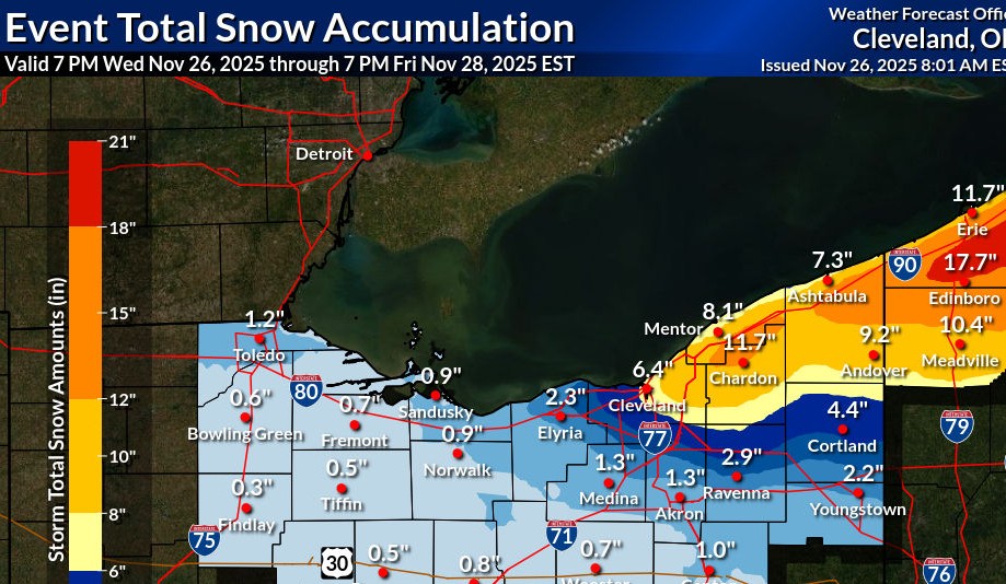
Reports coming with 6-13" away from the Lake to 3-5" along the shoreline. Decent storm. LES should be intense over in the UP later today into tomorrow.
-

Central PA Fall Discussions and Obs
WmsptWx replied to ChescoWx's topic in Upstate New York/Pennsylvania
ALEEEEEEEEEEEEEEEEEEEEEET!!! -
I could hear that all the way in Gaithersburg.
-
Come on.. dive it. The water is warm, just like you like it. Come on.. we're all in here. Even JI is splashing and giggling.
-
0.25" at mi casa last night and early this morning 1.02" for the month
-
Records: Highs: EWR: 68 (2011) NYC: 67 (1946) LGA: 67 (2020) JFK: 66 (2020) Lows: EWR: 15 (1938) NYC: 16 (1938) LGA: 24 (1940) JFK: 24 (1993) Historical: 1703: 400 windmills were destroyed by the greatest gale in the history of England caused by an intense low that passed just north of London. Many of the huge structures burned down from fires which started as their blades turned wildly in 80 mph winds. In London, roofs blew off and chimneys were toppled. The famed Eddystone Lighthouse was toppled by heavy seas. 123 people died on land, and another 8,000 died at sea as hundreds of vessels from the British fleet were lost, including four Men-Of-War. (Ref. Wilson Wx. History) 1888 - A late season hurricane brushed the East Coast with heavy rain and gale force winds. The hurricane passed inside Nantucket and over Cape Cod, then crossed Nova Scotia. (David Ludlum) 1896 - Snow and high winds hit the Northern Plains and the Upper Mississippi Valley, with a Thanksgiving Day blizzard across North Dakota. The storm was followed by a severe cold wave in the Upper Midwest. The temperature at Pokegama Dam MI plunged to 45 degrees below zero. (David Ludlum) 1950: Boston, Massachusetts on the 25th and 26th had a great easterly gale that caused $15 million damage. The strongest one minute average wind velocity was from the southeast at 80 mph. (Ref. NOAA Boston Weather Events) 1965: Snowstorm across northern U.S. with 14.7 inches at Duluth, MN 13.6 inches at Grand Rapids. (Ref. AccWeather Weather History) 1974: A record early snow hit Caribou, ME with 22.3 inches falling in 24 hours and a storm total of 30 inches. This storm was the major contributor to Caribou's snowiest November on record at 34.9 inches. (Ref. AccWeather Weather History) 1979: 74° on 25th and 26th are high point of 12-day warm spell 18th-29th in Washington, DC. (Washington Weather Records - KDCA) A strong cold front moved through the Mid Atlantic during the afternoon bringing thunderstorms and gusty winds. Kutztown, PA reported a gust to 70 mph, Reading, PA gusted to 65 mph, Allentown, PA gusted to 62 mph and Philadelphia, PA reported a gust to 59 mph. The gusts tore the roofs or portions of roofs off houses and other buildings. Many trees were uprooted or broken off. Rain ruined a large amount of chemicals when the roof of a storage building was blown away. (Ref. Wilson Wx. History) 1983: A major snowstorm hit from Colorado to Wisconsin through the 28th. A fairly consistent 1 to 2 feet of snow was reported. Sydney, NE had the most with 27 inches. Blizzard conditions prevailed with wind gusts as high as 60 mph. Limon, CO reported near zero visibility in snow and blowing snow for a solid 24 hours. (Ref. AccWeather Weather History) 1984: Copper City Utah:n an 18-hour period, the South Jordan and Copper City areas received 20 inches snow, while the eastern parts of the valley picked up only a couple of inches. (Ref. AccWeather Weather History) (Ref. Weather Guide Calendar with Phenomenal Weather Events 2011 Accord Pub. 2010, USA) 1987 - A Thanksgiving Day storm in the northeastern U.S. produced heavy snow in northern New England and upstate New York. Snowfall totals in Maine ranged up to twenty inches at Flagstaff Lake. Totals in New Hampshire ranged up to 18 inches at Errol. Gales lashed the coast of Maine and New Hampshire. A second storm, over the Southern and Central Rockies, produced nine inches of snow at Kanosh UT, and 13 inches at Divide CO, with five inches reported at Denver CO. (The National Weather Summary) (Storm Data) 1988 - Thunderstorms produced severe weather over the Central Gulf Coast States during the late morning and afternoon hours. Five tornadoes were reported in Mississippi, with the tornadoes causing a million dollars damage at Ruleville, and in Warren County. In Utah, the town of Alta was blanketed with 15 inches of snow overnight, and during the day was buried under another 16.5 inches of snow. (The National Weather Summary) (Storm Data) 1989 - A massive storm over the western U.S. produced heavy snow in Utah, Colorado, Wyoming and Montana. The storm produced more than two feet of snow in the higher elevations of northern and central Utah, bringing more than sixty inches of snow to the Alta Ski Resort in the Wasatch Mountains. Winds in Utah gusted to 60 mph at Bullfrog. The storm brought much needed snow to the ski resorts of Colorado, with 19 inches reported at Beaver Creek. (Storm Data) (The National Weather Summary)
-

December 2025 regional war/obs/disco thread
WinterWolf replied to Torch Tiger's topic in New England
Lots of pompous folks too. -
Lot of gobbledee gook?
-
Hmmmmmmm *Cracks knuckles*
- 268 replies
-
- 10
-

-

-

-

Nov 28-30th Post Turkey Day Wintry Potential
Baum replied to Chicago Storm's topic in Lakes/Ohio Valley
I put mine up to the Eurhthymic,’ s Green Christmas -
December 2025 regional war/obs/disco thread
WinterWolf replied to Torch Tiger's topic in New England
I wasn’t pointing out the caveats…I was talking about a coastal verse a SWFE…we discussed a couple days back, that this was not a coastal pattern. Now all of a sudden it might be for this potential. So we did not know that a couple days back. God, I guess you are forever correct, and nobody dare question Brian. God forbid we point out, or ask about something that wasn’t seen a few days prior… I guess only METS can point out the caveats…then it’s ok. But if we do, we are told we don’t need to hear them. Dooley noted. -

December 2025 regional war/obs/disco thread
Snowcrazed71 replied to Torch Tiger's topic in New England
Man you flip more than a flounder. You know you wanted as much as everyone else. And don't forget to give me that weenie... I know it's your favorite. ;-)