All Activity
- Past hour
-
At the end of each of their runs, the 0z GFS will drop a 946 tucked low that brings 72” of snow to the DMV while the 0z Euro drops 97 degree weather.
-
where did we go?
-
Yes, going to adapt to even less snow than Death Valley lol. It’s a mid Atlantic microclimate down here it seems.
-
I’ll add that today’s weeklies have a stronger -NAO/-AO forming for 1/12-2/1: 1/12-18: 1/26-2/1:
-
Under severe storm warning but barely anything on radar?
-
I saw that dark blob out there and went to the radar…what a day for early May!
-

December 2025 regional war/obs/disco thread
TheSnowman replied to Torch Tiger's topic in New England
Where exactly are you then? And what’s the case on Tuesday? People are just talking about todays Disaster that goes to the Canadian Border which I don’t want to talk about. I’ll be up in mid-NH Tuesday, will that be a 3-6 situation? -

E PA/NJ/DE Winter 2025-26 Obs/Discussion
Birds~69 replied to LVblizzard's topic in Philadelphia Region
Big fan of resetting 5-10 clocks multiple times a day because of power outages. Great fun! You would think in this day and age every appliance, every clock has a battery chip like a PC or laptop which retains the time even with a power outage which you usually only have to replace once a year. Most outages are short as in less than 2 hours... -
Hail and heavy rain in Sloatsburg. Wind gusts easily over 50mph. Saw towering cumulus congestus just before it started. No lightning or thunder here yet
-
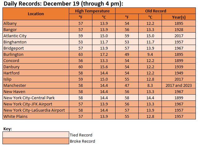
In addition to high winds and heavy rainfall, today was a day of record temperatures in many parts of the Northeast.
-

December 2025 Short/Medium Range Forecast Thread
Daniel Boone replied to John1122's topic in Tennessee Valley
Probably the increased likelihood of a Strong Block and bridge over along with possibly MJO becoming favorable would be my wag what's tipping them. It'll take a bit before my confidence builds. Main thing the next few days imo is to watch the progression of the NAO. Then that of the AR. -
We are so back.
-

Pittsburgh/Western PA WINTER ‘25/‘26
RitualOfTheTrout replied to Burghblizz's topic in Upstate New York/Pennsylvania
These squalls mean business. Combined with the wind and flash freeze roads are bad. Big wreck inbound on the highland park bridge. It was basically a sheet of ice. -
Until 18z
-
Look guys I know this is waaaaaaaaaaaaaaaaaaaaaaaaaaaaaaaaaaaaaaaaaaaay off topic up in here but we could all use a good laugh. I laughed so hard I think I managed to injure something and I am bound for the ER at St Davids in Austin right now, but I don't want any of you to miss out on any of the fun. I really WORSHIP all of the meteorological misfortunes in the Sierran Cordillera. All while I stand here all entitled, in 70s weather in south central Texas, with at least 10 days of well above normal weather on tap, all while everyone else gets to fight for their very lives in horrific wintry weather conditions. I think high winds at flight level are funny. I think people trying to get somewhere at the last minute for Christmas and getting stuck like Donners' party, is the absolutely funniest thing in the whole world! That part about the grievances being aired was what REALLY made me guffaw. Most people in this house now think I am completely out of my ever lovin' mind and stand in serious need of psychiatric intervention. 780 FXUS65 KREV 190927 AFDREV Area Forecast Discussion National Weather Service Reno NV 127 AM PST Fri Dec 19 2025 .KEY MESSAGES... * Widespread strong winds today and possibly again on Sunday. Likely impacts for both road and air travel. Localized fire weather concerns in the Eastern Sierra. * Showers including mountain snow showers this afternoon and evening. Heavier rains likely Saturday night through Sunday that could lead to localized flooding concerns. * Another storm or two could bring significant rain and snow Tuesday into Christmas Day, but confidence remains mixed. && .DISCUSSION... * Welp, it`s still looking rather busy weather-wise over the coming 7 days with a series of Pacific storms including atmospheric rivers. Anyone with holiday travel plans by road and by air should keep an eye on the forecast and adjust accordingly. * Wind: Today & Sunday are the windiest days in what will be a breezy period through most of next week. Rather impressive zonal jet moving though the Pac NW & N Calif coupled with increasing pre-frontal gradient will yield widespread strong winds today. Given W/SW flow orientation and 700mb speeds 50-60 knots, wave breaking and downslope enhancement is possible today along Hwy 395 from Susanville-Reno-Mammoth where we have wind advisories posted. Low humidity could create fire weather concerns, and it won`t be a pretty day for flying either. For Sunday another plume of high speed air aloft comes in with an moderate atmospheric river. RRFS showing 700mb winds over 70 knots. Wow. So if we end up being more shadowed on Sunday (more T than V from the AR IVT) we could have another round of rather strong, impactful winds regionwide. * Rain: While today will generally be dry, high-res models show showers moving in post-front this afternoon into the evening. Should be mostly rain except the Sierra peaks, however NBM and HREF are showing potential for snow p-type at passes if we see heavier precip rates. Rapid p-type changes can catch travelers off- guard. Saturday night through Sunday is still the main show for heavy rain with pronounced atmospheric river signal and high rain- snow lines (8000`+). QPF in the mountains is similar to guidance 24 hours ago but a little less in lee-side areas of W Nevada (more periods of shadowing/wind perhaps?). Highest risk of heavy rains and potential flooding remains the Tahoe Basin into NE Calif where models stall/pivot the main AR band for the longest time. If there were an area to underperform it would be the Eastern Sierra/Mono Co based on further north trajectories of the AR plume. * Snow: Precip never totally shuts off in the mountains but does lessen in intensity Monday into early Tuesday. Starting Monday night the snow lines drop enough were we could start seeing more regular impacts to travel over the passes. Simulations showing one or two additional notable and cooler storms moving in Tuesday evening through Christmas Day. Lots of variables here with models digging troughs off the coast which sometimes can result in a southward shift of the heaviest precip, wide boom/bust scenarios, and an increased airing of grievances next week. That all being said, QPF and snowfall in the NBM 50th percentiles has gone up quite a bit vs 24 hours ago for Wednesday-Thursday. Potentially good news for the snowpack and local "white Christmas" stats, but not so good news for those trying to get someplace at the last minute before Christmas. -Chris && .AVIATION... * Buckle up, it`s not exactly going to be a smooth day for flying with strong winds, mountain waves, rotors, and low level wind shear all on the table today into this evening. * Strong W/SW flow with RRFS 700mb winds to 60 knots forecast today and tonight, associated with an upper jet and approaching cold front. 80% chance of seeing peak gusts at least 35 knots at most airfields including RNO/CXP/MEV, TRK/TVL, MMH with 40-60% at NFL/SVE/HTH. High-end gusts over 50 knots cannot be ruled out in more wind prone areas along Hwy 395. NBM has 40-60% chances of 50 knot peak gusts at RNO and MMH for example. Another round of strong winds is looking likely on Sunday as well. * With that front today, we will have showers develop this afternoon and evening. Mainly in the mountains from SVE to TRK/TVL with potential for MVFR-IFR conditions in rain. Can`t rule out a rain/snow mix but low confidence. For RNO/CXP/MEV, light showers are possible (40% chance) but visibility/ceilings look to remain VFR. MMH misses out on this one, just wind for them. * Additional showers possible Saturday but mainly light intensity. Winds should be less robust as well. -Chris && .FIRE WEATHER... * There is concern over areas of critical wind and low humidity in the Eastern Sierra today, specifically fire weather zones CA274 and NV421. * Latest NBM and HREF guidance suggest 1-3 hours of critical conditions especially along Hwys 395 & 6 where W/SW winds could gust over 50 MPH this afternoon (see Wind Advisory). Humidity values already in the teens as of this writing and it`s been rather dry lately with well above normal ERC levels. * No Red Flag Warning at this time due to limited spatial extent and duration of critical conditions however we will highlight the risk in the FWF and our morning briefing email. -Chris && .HYDROLOGY... Repost of yesterdays hydro section. This will be updated with the daytime discussion. * Moderate to heavy rains will lead to significant rises on rivers and streams Sunday into Monday most notably from the Tahoe Basin north through Lassen County, but no mainstem river flooding is currently expected. * Minor flooding of urban and poor drainage areas and rockfall are possible during any prolonged periods of high intensity rainfall. Watch for additional rises near Christmas Eve and possible flooding concerns especially in drainages with large mountain drainages below about 6,000 feet, like the Susan River for example. * You can find river forecasts updated twice daily at: www.cnrfc.noaa.gov -Tim && .REV Watches/Warnings/Advisories... NV...Wind Advisory until 4 AM PST Saturday NVZ002-003-005. Lake Wind Advisory until 4 AM PST early this morning NVZ002. Lake Wind Advisory until 4 AM PST Saturday NVZ004. CA...Wind Advisory until 4 AM PST Saturday CAZ070>072. Lake Wind Advisory until 4 AM PST early this morning CAZ072.
-
outages have jumped to close to 25,000 in the JCPL footprint. that's about triple what we had this morning.
-
just gonna enjoy the old school weather local forecast Christmas music and reminisce back to when it did snow
-
Driving to Hartford soon for the Wolf Pack game. Haven't been since opening night (boooo) but trying to leave a tad earlier to avoid any squalls that might come in as early as 6
-
I was out all day. Got home a little while ago and looks like I lost power for a time. It’s back now but I have to reset the clocks. Maybe I’ll wait until the winds die down in case I lose power again.
-
Just had crazy loud crack of thunder in hackensack. Starting to pour.
-
1011 AM Non-Tstm Wnd Gst 2 S Rowayton 41.04N 73.44W 12/19/2025 M70 MPH ANZ335 CT Mesonet Mesonet station XGLL Greens Ledge Light. &&
-
Wild storm here. Definitely overperformed; the wind was crazy, and we had power outages all over the area. Just got my internet back an hour ago. Pack down to 5" in my yard, but you drive a mile down the road and it's been wiped out completely. Back to snow now at 34F
-
Indeed.
-
Went to rain/sleet/snow mix when winds were really gusting for 5 minutes. Now just rain. Temp dropping rapidly. 39.0
-

2025-2026 ENSO
donsutherland1 replied to 40/70 Benchmark's topic in Weather Forecasting and Discussion
For December through the first half of February, that's definitely the case. Big PNA- snowstorms are a rarity. However, once one gets to the second half of February, the PNA- is better (wave lengths are shortening).


