All Activity
- Past hour
-
I actually believe it. You're tough to rankle. I think Ginxy might have got under your skin once but he's a master.
-
My assumption for winter was it primarily a blend of 2013-14 and 2024-25. The weighting will vary between the two by month, but December now looks pretty warm West (like 2024) and pretty cold East (like 2013). Will be curious on the exact splits, as that's likely the correct weighting going forward and the pattern should weaken and then change by month end. Southwest US warmest Novembers on record tend to follow the same pattern here. For New Mexico the warmth slowly diminishes in intensity after an early-mid Nov burst with warm to 75F or so, until you eventually arrive at a seasonal or cool month in the late winter-spring transition. Our warmest Novembers here are 2017, 1995, 1949, 2021, 1999, 2020, 1954, 2007, 2012, 1965. 17-18 was never really cold, but it did go from no rain/snow for 96 days and warm, to a wet/cooler period mid-Feb to mid-Mar. Similar for 1995-96, 2021-22, 1999-00, 2020-21. 1949-50 was cold in Dec, same for 1954-55. 07-08 was cold Dec-Jan. 2012-13 was cold Jan-Feb - 1965-66 too. Since we didn't get the cold Dec here, almost all other periods following a super warm Nov are either very cold Jan-Feb, or Feb-Mar...so Feb is the signal.
-
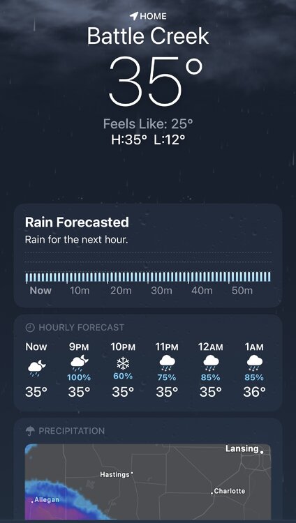
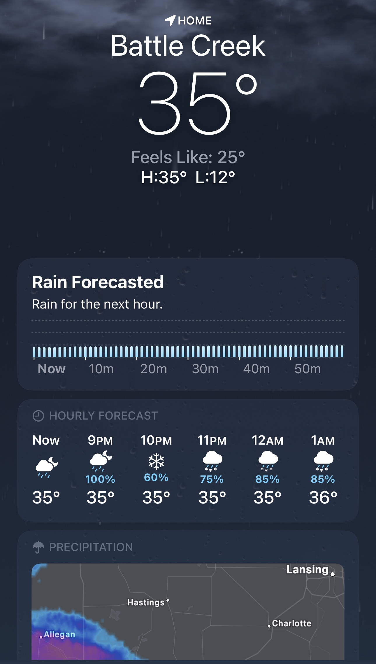
“Rain for the next hour”… Been snowing heavily since it started.
-

December 2025 regional war/obs/disco thread
SouthCoastMA replied to Torch Tiger's topic in New England
ah just saw the 18z euro, didn't realize it was mostly rain for the Cape. And 1/7/22 was also meh here. -
Yep. He’s not wrong that a snowless December in La Niña bodes poorly for the rest of winter, but a lot can happen in 3 weeks.
-

December 2025 regional war/obs/disco thread
Kitz Craver replied to Torch Tiger's topic in New England
LOL -
I don’t agree. Yes, the deep -IOD is a warm signal but it has weakened significantly since earlier in the fall, and the other factors are more tilted towards cold than say 89-90. 89-90 was a strong La Niña, this is a weak La Niña. Also, the PDO has risen a lot in recent weeks to weakly negative rather than strongly negative. I will concede that Feb has warmer risks, but think we are getting slammed in Jan. Maybe 1 warm week, but I think we go BN temp with well AN snow in the east, especially for northern areas. It will be interesting to see how things play out.
-
Leave tomorrow for Syracuse. Looks snowy my entire drive up, WWA for tomorrow. WSW for Thursday. May see 6” or so from lake effect. Would be nice to then come home to snow on Sunday
-
It won’t take much. We need it to move to phase 7 because that’s the precursor to our biggest storms. Ideal scenario is we get the standing wave on 7, and periodically we’d get incursions into 8>1>2, and then rotate back to 7.
-
MSP - 2.6” @ 6pm Measured 3.75” on my previously shoveled sidewalk at 7:15pm Back edge about to push through, should see wrap around snow overnight and add a bit more.
-

December 2025 regional war/obs/disco thread
powderfreak replied to Torch Tiger's topic in New England
Ha, I’m like that too. Some might say overly optimistic and can find a positive in falling face down into dog shit (is that corn?). I’ve been told it would be better if I got more upset… sports, weather, life, etc. -

December 2025 regional war/obs/disco thread
Damage In Tolland replied to Torch Tiger's topic in New England
Whoosh over your head . I’m generally the most optimistic poster here looking for positives. Yes, individual events get to me . I’m human . That one was one of most difficult since rain snow line was 3 Miles from me here and usually im a have and not have not with snow lines .I’m also generally not going to bring my personal life issues here like it’s a psych session . I think some folks use this for that . And that’s fine if it helps them -

December 2025 regional war/obs/disco thread
Baroclinic Zone replied to Torch Tiger's topic in New England
Lol snowhole over his locale.
-
December 2025 regional war/obs/disco thread
Damage In Tolland replied to Torch Tiger's topic in New England
I’m not telling anyone what to do . Everyone has life issues to deal with. But I had to stop reading without blocking. I’m a glass half full . My glass is never half empty of an IPA. I’ve never blocked anyone . -
December 2025 regional war/obs/disco thread
powderfreak replied to Torch Tiger's topic in New England
I will say over the years when DIT gets down, he doesn’t stay down for long. -
Yeah seriously. He just said earlier today is close to being committed to Bellevue. Frankly I am too.
-
Historic torch is gearing up for second half of December, rubber band going to snap back hard
-
Goes with the pattern of late where LR warmth is muted.
-
Virginia snow reports from NWS Snow Reports Dec 8-9, 2025
-
By the end of the Gefs 18z run (Christmas Day), the ridge across the country has been squashed far enough south to result in normal 850 temps and BN surface temps. Coincidentally, just like the Cansips was showing for the month of January I mentioned earlier today in this thread.
.thumb.png.98d6ead75427c0e87717193d731d116e.png)
.thumb.png.d3c86cd794fc24f294160c17c2c42689.png)
.thumb.png.59f1bf8e0f2f31a8b3a577e8b69cd732.png)
-

December 2025 regional war/obs/disco thread
HoarfrostHubb replied to Torch Tiger's topic in New England
Weren’t you close to jumping off the Charter Oak Bridge the other day because you missed out on one inch of slop? -
December 2025 regional war/obs/disco thread
powderfreak replied to Torch Tiger's topic in New England
The woe is me cycle can be incredibly hard for some people to get out of… and draining for all around too. -
From channel 13 Author: Craig Moeller Published: 7:35 AM EST December 9, 2025 Updated: 12:49 PM EST December 9, 2025 HAMPTON, Va. — Monday’s winter storm delivered a sharp divide in snow totals across Hampton Roads, with neighborhoods just miles apart seeing drastically different amounts. While areas closer to the bay picked up little accumulation, communities farther north and inland measured several inches. Great Neck and Western Branch each saw around 2 inches of snow, while Greenbrier came in just under that mark. Princess Anne recorded 1 inch, and Norfolk International Airport measured only 0.5 inch, reflecting the lighter totals along the water. On the Peninsula, however, the storm packed a bigger punch. Denbigh reported 5.7 inches, and Menchville reached 6.9 inches, the highest total in the region. To the west, White Marsh came in at 4.5 inches, and Kilby in Suffolk recorded 3 inches. Though the snow ended on Monday, its effects lingered into Tuesday Those Denbigh and Menchville totals were further up the Peninsula from me. Im on the souther part. I estimated 3.5 here.
-
Not that we've ever seen it before (sarcasm), but I wonder if the LR MJO forecast phases could be incorrect? Seeing alot of posts over the past 36 hrs "mjo says cold phase so its gotta be cold". It doesn't gotta be anything if the MJO forcing is incorrect.
-
.thumb.png.4150b06c63a21f61052e47a612bf1818.png)
December 2025 regional war/obs/disco thread
HIPPYVALLEY replied to Torch Tiger's topic in New England
Wow, I don’t think I’ve ever seen folks slip downhill this early in the season.


.png.34175bce70cc6a12080ce31a13234b30.png)
.png.f5a405d85af8bc143d8ced825cd08385.png)
.png.47324e161ed059631e41b67d46c9b084.png)
