All Activity
- Past hour
-
Some times, These little critters bite.
-

December 2025 regional war/obs/disco thread
HoarfrostHubb replied to Torch Tiger's topic in New England
-

December 2025 Short/Medium Range Forecast Thread
Carvers Gap replied to John1122's topic in Tennessee Valley
Basically, the December 1995 pattern would repeat later that winter, but with better climatology in place for cold air to make it to this latitude and hold. IMBY(not the folks at elevation), we are fighting climatology every step of the way right now. It eases up after Dec 10th or so, and becomes more favorable with each day. When I first started tracking, I rarely tracked during the first 20 days of December. But if this pattern were to repeat during the second half of winter, I think the cold presses more. Now, the STJ is inactive...so northern stream systems are gonna have to do the trick. I still think we have a shot to score before this breaks just short of Christmas. One caveat, this may not break down before Christmas. Some MJO plots are stalled through the end of the month and into early January on the left side of the MJO. Also, modeling tends to break down patterns a bit too early. That said, a New Year's thaw seems realistic. If it is twenty below w/ five feet of snow...you can look back on this comment and thank me for it! -
Temp is 33 and steady (if light) snow. Not amounting to much given the marginal temps, but it sure beats 38 and rain. Maybe some of this energy makes it over the hills?
-
Currently 34.9 IMBY, 33 at Newport News International Airport like 2 miles west.
-

Digital Snow/Ice Thread 2025-2026
Leesville Wx Hawk replied to WinstonSalemArlington's topic in Southeastern States
What could go wrong [emoji1783]? . -
Play of the week
-
Yesterday, the forecasted high was 50 and I only got up to 42.
-
December 2025 Short/Medium Range Forecast Thread
Carvers Gap replied to John1122's topic in Tennessee Valley
The Euro Weeklies this evening strongly hint at a 95-96 type of progression. Warmup around Christmas. Cold returns mid-Jan or just after. That also fits the pattern of recent winters. The good thing about all of this...eastern portions of the forum have missed w/ the second cold shot during recent Nina winters. I doubt that happens this winter. I think the cold in later January pushes to the coast. Just a hunch. -

December 2025 Short/Medium Range Forecast Thread
jaxjagman replied to John1122's topic in Tennessee Valley
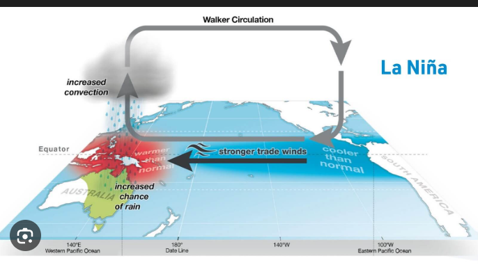
It dont look very cold cold to me in the long range,this is in part due to the Walker Circulation ,when you see these strong EWB'S this strenghtens the Walker circulation and pushes the Jet Steam the jet more Northward in winter time during LaNina,in summer time we can see droughts in our parts,which is what we seen this summer,this is what you seem to be seeing right now with the ensembles long range.thumb.gif.1f7dee41e2c9a7f456fa10c724457ed2.gif)
-
Forecasted high 54, actual high 45. Clouds hung tight. Low was 31.
-
35
-

December 2025 regional war/obs/disco thread
Damage In Tolland replied to Torch Tiger's topic in New England
This is money time for snow . Dec 1 - Feb 15. After that it loses the appeal . Each day and week is one less to enjoy winter before spring season. Regardless of if it can snow into Morch . It’s not nearly as enjoyable -

December 2025 regional war/obs/disco thread
powderfreak replied to Torch Tiger's topic in New England
The previous seasons do not help, I think most of it is rooted in that. That’s how I was for a while in the 2010s when SNE was pulling bombs left and right. 12-24” grew on trees it felt like 2010-2015 down there and we couldn’t do 6+ in a single event. Even 2015-16 sucked overall (all-time bad up north) but CT was getting stripes of 15-inch events through the heart of the state. We’ve all been there. It ebbs and flows. -

2025-2026 ENSO
Stormchaserchuck1 replied to 40/70 Benchmark's topic in Weather Forecasting and Discussion
Remember, in November it usually takes a Stratosphere warming +30-35 days to impact the NAO (-NAO). Based on CDC reanalysis maps, I'm saying Nov 21 was the first day of 10mb warming. Here it is to Dec 5: Not real strong.. I'd say a 4-5/10 warming, but 11/21 is +35 days -- Dec 26, and 12/5 is +30 days -- Jan 5. So watch Dec 26 - Jan 5 for a turn to more -NAO conditions. That isn't on 2-week model progs yet. -

The Monday wintry event potential (12/8/25)
Orange county replied to GaWx's topic in Southeastern States
Okay I am not an educated person lol -

December 2025 regional war/obs/disco thread
SnowGoose69 replied to Torch Tiger's topic in New England
It’s hard to know now because ensembles suck with this pattern. When you look at many of the individual members on days 10-16 you can see they are actually quite cold in the east. We are getting skewing on many ensemble averages by some members that crank raging zonal patterns by trying to place the ridge all the way to the east coast. Probably need to see the WPO go positive in order to have this totally come off the rails -
Super foggy out again at 34 degrees .
-
.thumb.png.4150b06c63a21f61052e47a612bf1818.png)
December 2025 regional war/obs/disco thread
HIPPYVALLEY replied to Torch Tiger's topic in New England
Some on here swear there’s only 8 weeks of snow left. -
Chicago has been off to a quick start: "Chicago picked up another 4.8" of #snow ..... with their season to date total now at 17.1" vs. the average of 3.5". This is the fastest start in 47 years and just shy of what fell all of last season: 17.6"."
-

December 2025 regional war/obs/disco thread
Kitz Craver replied to Torch Tiger's topic in New England
I mean I’m not saying winter is over, I just feel like we could potentially squander a favorable backdrop for winter weather, which exacerbates the ptsd of prior season failures. -
We are slowly dropping but almost stalled at 33.7
-
2025-2026 ENSO
Stormchaserchuck1 replied to 40/70 Benchmark's topic in Weather Forecasting and Discussion
Wow- big shift on 18z GFS ensembles to +NAO in the medium and long range. Natural Gas opened gapping down in price. -
lol. People need to deal with it. I’d rather it was still 60°. I’m only happy about the pack because it’s cold. But it’s true. It’s 12/7. The whining is dumb. There’s 4 months of snow season left.
-

Digital Snow/Ice Thread 2025-2026
WinstonSalemArlington replied to WinstonSalemArlington's topic in Southeastern States

.thumb.JPG.418e8a9a2902ae687ec35ff4bc0e038e.JPG)


.gif.469c76a92091bafca7a10cb6e4bf2c4e.gif)


