All Activity
- Past hour
-
Ended up with mostly sleet here mixed with rain. Actually can see a coating in the mulch, on the deck, and the roof. Temp is 35.
-
I’m starting a gofundme for my February BGE bill. WTAF
-

Storm potential January 17th-18th
LoboLeader1 replied to WeatherGeek2025's topic in New York City Metro
Auto body shops love this kind of weather, numerous spin outs on the Hutch this afternoon. -

E PA/NJ/DE Winter 2025-26 Obs/Discussion
Chadzachadam replied to LVblizzard's topic in Philadelphia Region
Tapering off we’ll call it 0.75” here. 8” for the season -

Another Coating of Snow Saturday - "It's all we Got"
ORH_wxman replied to Sey-Mour Snow's topic in New England
That band is crushing ORH KORH 171754Z 21008KT 1/4SM R11/2200V2800FT +SN FZFG VV009 M01/M02 A2994 RMK AO2 SLP153 P0003 60005 T10111017 10006 21039 58033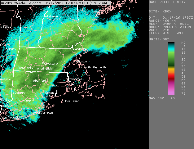
-
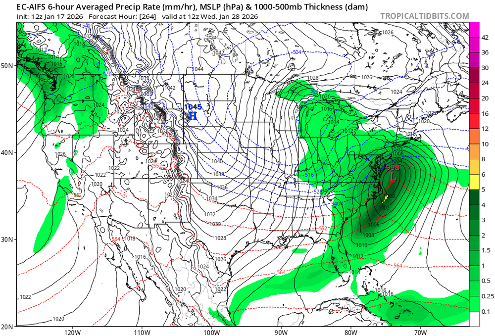
Euro AI puts all its eggs in the Jan 27-29 basket. Pretty sure most of us would take this look at this range. Eta: just a triple phaser based on h5 vort, nothing to goon over
-

Storm potential January 17th-18th
binbisso replied to WeatherGeek2025's topic in New York City Metro
Tomorrow's snow starts around 4am will have no problem sticking with a temp around freezing -

Another Coating of Snow Saturday - "It's all we Got"
FXWX replied to Sey-Mour Snow's topic in New England
Your area looked like the best shot for 4" in CT... sitting at 3" in Burlington with moderate snow... -

Another Coating of Snow Saturday - "It's all we Got"
Johnno replied to Sey-Mour Snow's topic in New England
headed for 4” total here, we over perform -
I'm live reporting from, Mount Hoboken. Elevation, 11 feet. Snow on the ground.
-

E PA/NJ/DE Winter 2025-26 Obs/Discussion
Kevin Reilly replied to LVblizzard's topic in Philadelphia Region
snow currently quickly tapering to flurries here 33f humidity 79% dew point 27f Total snowfall here 2.3" Total for the year: 11.7" -

First Legit Storm Potential of the Season Upon Us
hooralph replied to 40/70 Benchmark's topic in New England
I hope Borregales has been taking all his practice kicks in the cold and snow (when it was there) for weeks. Venezuela-> Miami-> Foxboro in January. -

Another Coating of Snow Saturday - "It's all we Got"
Damage In Tolland replied to Sey-Mour Snow's topic in New England
2.2” here -
Roads are a mess in Brooklyn
-
GFS and Euro AI both had a big one for the 29th.
-
Pleasant surprise here. Over 1” and sticking to everything, including main roads.
-
Storm potential January 17th-18th
LoboLeader1 replied to WeatherGeek2025's topic in New York City Metro
Currently 31 here, around an inch OTG now. -
Ahhhh..the year NashSevereWX came up with the snow dome after the WSW and we got nothing but rain,and it took off with the public.Bobby Boyd use to use it in his disco but he explained the reason was Nashville is in a basin so things like this will happen.But it lasted for almost a decade it seems
-

First Legit Storm Potential of the Season Upon Us
vortex95 replied to 40/70 Benchmark's topic in New England
I am not impressed overall w/ this event, despite the storm further NW. MOS shows sfc temps 34-38 F for much of the event across much of CT, all of RI, eastern MA, and Cape Cod. And precip intensity is not nuts, so despite the cold 850 and 925, the BL remains a big problem. There is zero high pressure to our N. In fact, it is one big trough from Labrador to the Great Lakes. This is rare for a coastal storm, and key for ptype in this event. So the low-level cold is limited, and more importantly, there is no solid N or NE sfc/BL wind to constantly drain the cold air to the N into SNE during the event. Winds are going to rather light for coastal storm, relatively speaking, so this is going to cause issues. Just before the precip starts in BOS on the NAM, the BL wind is 24011 and 6 hr later it is 1404. Does that look like a wind direction/trend that is conducive to significant snowfall? Also BOS buoy SST is 42 F. W/o solid ageostrophic flow and a mechanism to drain low-level cold air from the N into the heavier precip area, again, this is a big problem for ptype. You need this to offset relatively mild ocean temps. And what falls and SOG is likely to be quite different many areas. So I would temper expectations here. Not a big storm (MEH for central pressure and deepening rate) and really no different that the piecemeal, nickel and dime events for snowfall we have dealt w/ so far this winter. -
Storm potential January 17th-18th
binbisso replied to WeatherGeek2025's topic in New York City Metro
Yup just measured 1.2" here in mt vernon -
Another Coating of Snow Saturday - "It's all we Got"
FXWX replied to Sey-Mour Snow's topic in New England
They are... solid in Burlington with 3 on the ground -
If we could get this thing to shift northwest about 50-75 miles we’d be golden here for at least a low impact event. I’d take an inch of snow on the ground at this point! Starved down here LOL! .
-

E PA/NJ/DE Winter 2025-26 Obs/Discussion
Prairie Dog replied to LVblizzard's topic in Philadelphia Region
As of 12:15 PM.......................Langhorne, Bucks County 1.5 inches, moderate snow and 32 F -

First Legit Storm Potential of the Season Upon Us
CoastalWx replied to 40/70 Benchmark's topic in New England
Yeah, that’s true too, good point. -
First Legit Storm Potential of the Season Upon Us
CoastalWx replied to 40/70 Benchmark's topic in New England
Yeah we don’t want that. We want the Tblizz Truffle Shuffle west.


