All Activity
- Past hour
-

The “I bring the mojo” Jan 30-Feb 1 potential winter storm
KChuck replied to lilj4425's topic in Southeastern States
Can we get group rates??? -
Yeah, big picture, it's good news. In the moment, I totally get the frustration. The atmosphere is a fickle mistress when it comes to snow desires for sure...
-
jan 2005?
-

February 2026 Medium/ Long Range Discussion: Buckle Up!
Heisy replied to Weather Will's topic in Mid Atlantic
Down the line western trough/-PNA showing up, if we hold the blocking and run that energy into the cold that’s built up I could see some major mid month storm like we saw with the last event. Hopefully we can avoid any ridge bridging in the east -
Separate. But now I wonder if he meant to say E based Nino.
-

1/30-1/31 Lake Effect Snow Threat - SE WI, NE IL, and NW IN
Chicago Storm replied to A-L-E-K's topic in Lakes/Ohio Valley
SN/+SN for over an hour now at ORD. -

The “I bring the mojo” Jan 30-Feb 1 potential winter storm
Ravens94 replied to lilj4425's topic in Southeastern States
.thumb.gif.e1862f1dfa091e6e295fcde93f6552ab.gif)
-

The “I bring the mojo” Jan 30-Feb 1 potential winter storm
ADB83 replied to lilj4425's topic in Southeastern States
NAM is literally just playing hopscotch skipping back-and-forth every run. It didn’t even screw the Triad that run. I have zero confidence in what’s going to happen to be honest . -
.thumb.jpg.6a4895b2a43f87359e4e7d04a6fa0d14.jpg)
Central PA Winter 25/26 Discussion and Obs
Yardstickgozinya replied to MAG5035's topic in Upstate New York/Pennsylvania
This is the first big changes. We've seen what the SPC outlook in a long time. SPC will transition to issuing conditional intensity information beginning with the 1630Z (10:30 AM CT) Day 1 Changes to Storm Prediction Center (SPC) Day 1, 2, and 3 Convective Outlook Probabilities of Significant Severe Hazards on March 3, 2026 https://www.spc.noaa.gov/exper/conditional-intensity-information/ -
 Anyone have the latest graf model to post?
 -
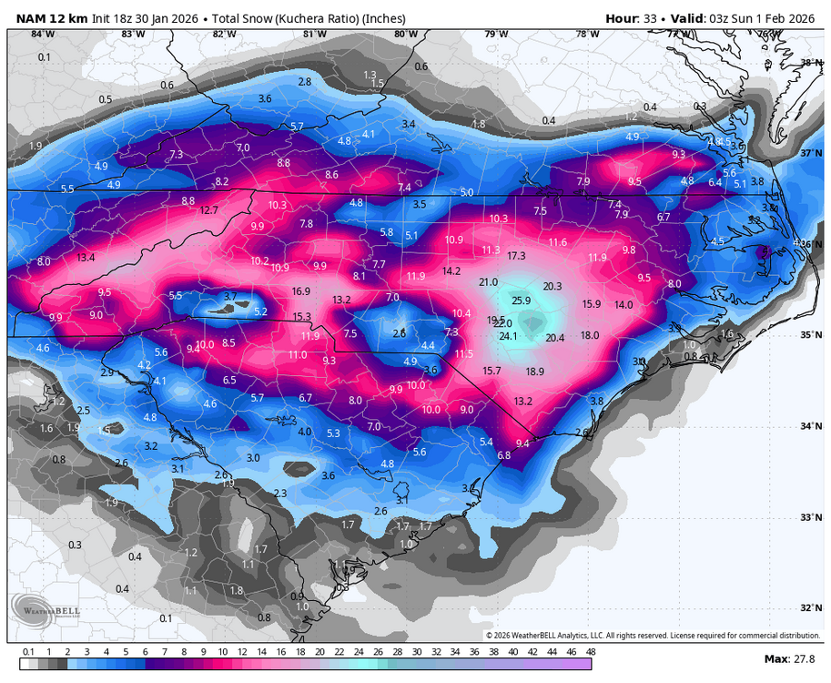
Still running but the 3k has widespread 8-10”
-

The “I bring the mojo” Jan 30-Feb 1 potential winter storm
KrummWx replied to lilj4425's topic in Southeastern States
We're like 12 hours from the event and I've been following this from the beginning. 0 clue what's going to happen IMBY lol. Literally anything from 0" - 12" seems possible. Outrageous. -

The “I bring the mojo” Jan 30-Feb 1 potential winter storm
olafminesaw replied to lilj4425's topic in Southeastern States
The HRRR is really only good for taking radar trends as the event unfolds (under 8 hours) and creating a kind of future radar projection. And for thermal profiles. I wish they had never made it run past 18 hours -

The “I bring the mojo” Jan 30-Feb 1 potential winter storm
lilj4425 replied to lilj4425's topic in Southeastern States
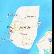
Seriously. Either Raleigh gets nothing or a foot. It’s crazy how far off these models are from each other this close to game time. -
The “I bring the mojo” Jan 30-Feb 1 potential winter storm
wake4est replied to lilj4425's topic in Southeastern States
-
3 metro airports are all at or above climo season to date, right?
-

1-30/2-1-26 Arctic Blast, ULL Snow Event
fountainguy97 replied to John1122's topic in Tennessee Valley
wow these 18z models are hitting hard. Johnson city over 15" on 3km NAM -
The “I bring the mojo” Jan 30-Feb 1 potential winter storm
KChuck replied to lilj4425's topic in Southeastern States
Or the Triad -
The “I bring the mojo” Jan 30-Feb 1 potential winter storm
Ravens94 replied to lilj4425's topic in Southeastern States
This is going to be a crusher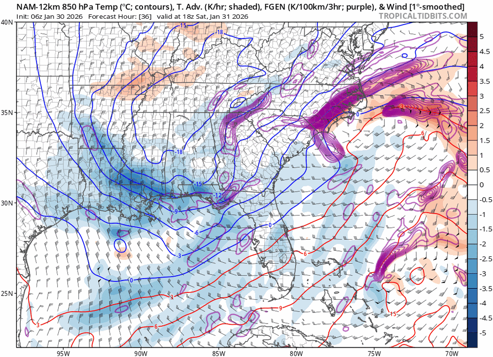
-

The “I bring the mojo” Jan 30-Feb 1 potential winter storm
Regan replied to lilj4425's topic in Southeastern States
Grab my hair. -

January 30th- Feb 1st ULL and coastal storm obs
kvegas-wx replied to JoshM's topic in Southeastern States
Steady flurries in Stuart Va on the farm cams! Likely snowing all down the VA border into the foothills. -
The “I bring the mojo” Jan 30-Feb 1 potential winter storm
clt_25 replied to lilj4425's topic in Southeastern States
Howdy neighbor! Yes hard to believe this storm is somehow disabling the CLT weather dome force field! -

The “I bring the mojo” Jan 30-Feb 1 potential winter storm
BornAgain13 replied to lilj4425's topic in Southeastern States
These models are horrible lol... just absolutely atrocious and hardly any consistency especially the short range -
Does east QBO mean east-based Niño, or is that a separate thing?
-
The “I bring the mojo” Jan 30-Feb 1 potential winter storm
Ravens94 replied to lilj4425's topic in Southeastern States
Nam has shifted instability south. ILM south and west is full of lift


.gif.a77fdb6ea57f36fa3ae4a3da373ed7e3.gif)


