All Activity
- Past hour
-
Good luck with the wind
-

“Cory’s in NYC! Let’s HECS!” Feb. 22-24 Disco
Snowcrazed71 replied to TheSnowman's topic in New England
Your a dork...lol -
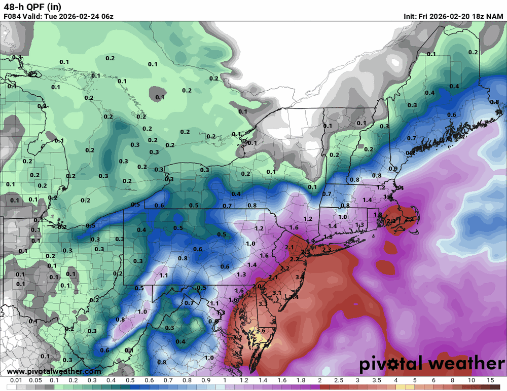
Looks like an area wide HECS
-

“Cory’s in NYC! Let’s HECS!” Feb. 22-24 Disco
Ginx snewx replied to TheSnowman's topic in New England
Actually with 850s at minus 12c 925 -9 and surface temps 22⁰ I would expect the last .75 of qpf to be 16 to 20 to 1 , add 6 to 8 " -
This is a tough forecast especially for the western suburbs of DC which may be to warm for the coastal snow and may be to far west for much snow from the IVT.
-
I think we’ve had two today.
-
It's legitimately ridiculously close to being an all-time HECS for 95. We have time to get those 50 miles.
-
Didn't the January 25th storm pop one i think it did
-
I like my omega perky
-
I don't think I've ever been double NAM'd!
-
they were going to be anyway.....
-
I think, could be wrong, that the NW cutoff will be less because this isn't a true Miller A. The inverted trough is still a bit of a wild card.
-
Thank you both!
-

“Cory’s in NYC! Let’s HECS!” Feb. 22-24 Disco
RUNNAWAYICEBERG replied to TheSnowman's topic in New England
I hate those double max zones that always skip CT. -

“Cory’s in NYC! Let’s HECS!” Feb. 22-24 Disco
weatherwiz replied to TheSnowman's topic in New England
This looks a little fun -
50 miles west is all we need.
-

“Cory’s in NYC! Let’s HECS!” Feb. 22-24 Disco
Typhoon Tip replied to TheSnowman's topic in New England
I told you earlier...I've been using my Jedi powers to move that house sucker low to LI... My plan is almost complete - -
NAM verbatim is Blizzard warning criteria
-
Haven’t seen an eye feature in a while this looks like February 2010.
-
Yes and anyone to the west of the banding will be less than satisfied with all the sinking going on.
-
For this to be a big storm, we had to get at least one insane NAM run. If it looked more like the Euro I would have been worried. Now have to hope the GFS holds.
-
Hopefully, The Nam is on the right track.
-
Hitting a wall there per radar.
-
And everybody is at or below freezing.
.thumb.png.de6cc3ccc9f67560890a0d21628846dc.png)
.thumb.png.d4931dab5f5e4a7fea06f2df74548269.png)
-

Central PA Winter 25/26 Discussion and Obs
MAG5035 replied to MAG5035's topic in Upstate New York/Pennsylvania
At some point soon something’s gotta give with this US vs non US guidance in terms of the top end potential. GFS and NAM totals would be an all-time snow event for the Delmarva and at least a top 10 type event for NJ and NYC.

.thumb.png.991e09c19c25af7391ed569a205a5136.png)


.png.0f1846df708372827168a4c7109da56b.png)
.png.aad13ebead4f821fd6cad8224e29961e.png)