All Activity
- Past hour
-
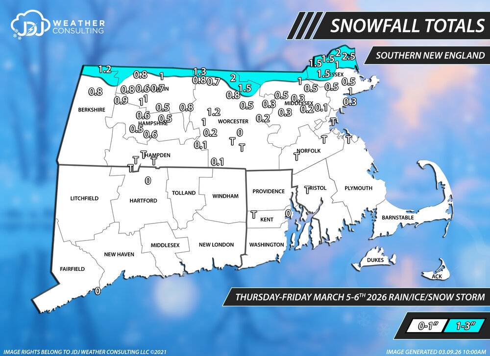
Snowfall totals from this event...thrilling stuff A little odd to me that ORH didn't even report a T for this event, just a big zero. All the SNE snowfall maps for this season are up here, so far there is 24 events https://www.jdjweatherconsulting.com/sne-25-26
-
I saw my first blooming crocuses yesterday. Daffodils have been poking out for 2ish days but no blooms yet.
-
starting this weekend cold enough air for snow making will return and probably last into a good portion of April for ski resorts that choose to remain open - mainly caused by the Start Warming event now unfolding.
-

Winter 2025-2026 Offers Return to Normalcy
40/70 Benchmark replied to 40/70 Benchmark's topic in New England
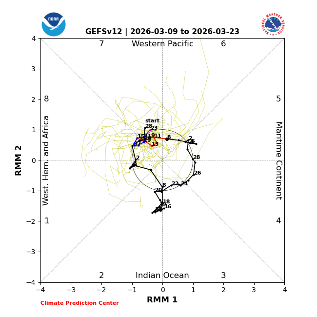
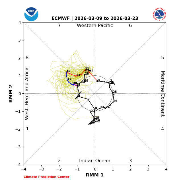
Spring Preview This Week Followed By Mid-Month Regression Cooler & Stormier Start To Astronomical Spring As the conclusion of the harshest winter in about a decade comes into focus, those beleaguered by the season begin to look forward to spring with great anticipation, and it just so happens that Mother Nature is obliging this week. Indeed, the progression of the MJO through the Maritime Continent is treating New Englanders to a bona fide spring preview this week, as temperatures soar through the 60s today, and even potentially past 70 degrees tomorrow across the forecast area. Note the similarity between the current pattern that is poised to bring near record warmth across the east. And the regime associated with passage of the MJO through phase 6 during early to mid March. One consequence of a mild pattern such as this is that the cold is afforded ample time to pool near the pole, which leaves the mid latitudes vulnerable to future incursions should the pattern permit, and in a season such as this not often will. Astronomical Spring More Akin To Late Winter This Year Mother Nature often refuses to abide by the calendar definition of seasons, which is but a mere artifact of Astrology, and at no other point of the year is this more evident in New England than the Spring. If one is in search for a deviation from that trend, then this is not the year to conduct a fruitful search. Last summer, Eastern Mass weather began making a case for why the coming cold season was likely to display a propensity for episodes of cross polar flow due to the expected configuration of both the polar domain, as well as the extra tropical Pacific. This analysis has proven very prescient in nature. It would stand to reason that "spring" 2026 may have one last bitter pill for the region to swallow and it just so happens that there are indeed signs that that will be the case. Note the progression of the MJO wave out of the MC and into phases 7 and 8. Although the wave is forecast to weaken markedly upon passage into phase 8, currently it is forecast to impress on the tropical forcing pattern, nonetheless. Here is the pattern that this type of forcing regime in mid-latter March, approaching the equinox would entail. This should look familiar. There is also a strong storm signal centered on the 16th, as a PNA judge flexes into existence for perhaps one final time. Obviously the cold will undoubtedly be less severe and more ephemeral in nature than it was during the heart of the boreal winter season, but one last winter storm can not be ruled out, especially across the distant interior between now and the "astronomical" start of spring. A cold rain likely on the coastal plain at this extended juncture; spring in New England, indeed. -
https://easternmassweather.blogspot.com/2026/03/spring-preview-this-week-by-mid-month.html
-
Down to just patches of snow cover here this morning. I spent the weekend in the Catskills. Snow is patchy at the trailheads (almost gone in spots), but at least a couple of feet remains starting around 2500 feet and more higher. In most places the snowpack is thoroughly rotted. It has no structure and if you go off the packed tracks you sink to the bottom with very little resistance. Some of the trails were washed out rivers on Sunday. The snowpack there is going to release a lot of water between now and Wednesday.
-
Central Park: 78; LaGuardia Airport: 79; Newark reached 80.
-
Also add that we need a volcanic eruption for a snowy winter.
-
Absolutely. Still an outside shot of something between 3/18-3/21 but we'll need some luck in clown range.
-
Cant say that just yet. We can trend back to a snow event . Need the cutter to be weaker.
-
Here in UHI world I think we are a solid 14+ days behind where we have been in the past several winters. We have a lot of crocuses blooming in random sunny spots in parks; in past years, those bloomed as early as Feb 18th-24th.
-
52/35
-
Close on February 21 2018 it hit 78 (old record was 68 in 1930 which stood for 88 years!!!!)
-
looking good for a chase tomorrow, HRRR has 4.2k surface CAPE in IL which is just unreal... agreed that the biggest question is just whether storms pop or not before 00/01z, to actually be able to see something while chasing
-
Yeah that would have been great to have. Thought we’d have some blocking this month but doesn’t appear in the cards. I’m sure it will come in April.
-
Good morning ESN+. For us it will probably occur just before a more dramatic redo of the Blizzard of 88. Stay well, as always …..
-
54 at Worcester... 39 at Fitchburg
-
Today’s MJO forecasts: GEFS EPS: @EastonSN+
-
I would have thought Feb 2018 had an 80 in NYC?
-
What about Feb 2018?
-
3/16 would work with any blocking or confluence, but nada
-
When will we break this one: "The earliest in the year that New York City had a high temperature of at least 80 °F is March 13 which happened in 1990."
-
How can you debunk statements which were never made in the first place? This was our first winter with benchmark KU events since January 2022. There wasn’t a statement made that we would never see benchmark storm tracks again. What was discussed was how long it would take for them to return and what mechanism would be involved. All it took was one of the earliest November stratospheric warming events related to the -QBO and record low sea ice. But such events aren’t well forecast much in advance. Record Western Pacific SSTs mean frequent MJO 4-7 phases but not always constant. This was our first successful MJO 8 event since January 2022. The NAO has frequently been connecting with the Southeast Ridge but not 100% of the time. In fact, the Southeast Ridge link up back in December with the -NAO worked in our favor with the strong -WPO to prevent suppression and deliver a snowy clipper. Record warm ocean temps mean the Southeast ridge has been dominant but intervals when it relaxes have occurred from time to time. Fast flow is an increasing feature as the planet warms. But we saw the first relaxation of this pattern for the blizzard in late February for just long enough for all the pieces to come together in years. Snowy Clippers were very infrequent prior to December and we finally got two great ones after a long hiatus. In reality what we have experienced has been a shift to all or nothing snowfall seasons since the 1990s. So our winters either swing for fences like this winter and and get a bunch of home runs or we strike out like the prior 3 winters. The sense of balance like we used to have with frequent 18-29”snowfall seasons prior to the 1990s has been lacking. So now it’s mostly under 20” or even 15” seasons and over 30”. The challenge with this type of regieme is that we need some exotic device to get the great snowfall outcomes like this winter with one of the earliest SSW in 75 years. We have been doing better than a place like State College which hasn’t had a great Miller A east of the APPS track in over 20 years. So they have been missing out with all the Great Lakes cutters west of the APPS and benchmark tracks which favor the coast.
-

Central PA Spring 2026 Discussion/Obs Thread
pawatch replied to Voyager's topic in Upstate New York/Pennsylvania
31 degrees and a frost. Next week, just deal with what Mother Nature sends us. River at a warning level so no fishing yet this year. -
Kalshi has NYC over/under 71 today. What side are we on? lol


.thumb.jpg.ad3a2e31d30aff035044689b311a0540.jpg)


