All Activity
- Past hour
-

Augdewst 2026: Summer's Last Stand
Brewbeer replied to Prismshine Productions's topic in New England
Let’s hope not. 76/71, dewscusting out there right now -
 Order Viagra 50 mg online and Cheapest Sildenafil online Cheapest Sildenafil online https://www.google.tg/url?q=https://medmennews.com Viagra Tablet price and http://dnp-malinovka.ru/user/bhekefdase/?um_action=edit order viagra [url=http://www.polseguera.org/cgi-bin/forum/gforum.cgi?url=http://medmennews.com]buy Viagra over the counter[/url] Cheap Sildenafil 100mg and [url=https://rightcoachforme.com/author/mxtvowzgqb/]Order Viagra 50 mg online[/url] Cheap Sildenafil 100mg
 -

2026-2027 Super El Nino
mitchnick replied to Stormchaserchuck1's topic in Weather Forecasting and Discussion
So you think everything in law is black and white? You're kidding me right? The point you miss is one doesn’t need to say a lot to make a point. The past 2 or 3 months, you've been triggered every month with the updated seasonal forecasts because they haven't shown a furnace in the east. In essence, your warning is models have under forecasted the strength of ridges in the past which "could" be taken as guaranteed future results i.e. stronger ridges resulting in more heat. But no real forecast because we just don't know yet...but it still "could." That really is the sum and substance of all those posts the way I see it. Where am I wrong? -
Incredible post. I remember tgese big heat years and long duration heatwaves. Being in the landscaping business i know something about summers. Welcome back. I miss you and your love for heat
-

Augdewst 2026: Summer's Last Stand
Damage In Tolland replied to Prismshine Productions's topic in New England
I’d be willing to bet dews stay in the 60’s Tuesday . That front really doesn’t move all the way through cleanly -
buy viagra here: sildenafil online - buy viagra here
-
From SPC day 4 to 8 outlook this morning Days 5 and 6/ Thursday and Friday... A slight eastward shift of the mean trough position is forecast on Thursday with some model signal for an embedded short-wave trough to move through the Great Lakes. At the surface, there is some suggestion that a weak front or wind shift will move into the northern Mid-Atlantic during the afternoon with the trailing extension of that boundary stretching through the mid MS Valley into the southern High Plains. Ahead of that boundary, widespread 70+ F dewpoints are expected from New England into the Mid-Atlantic and Carolinas, leading to moderate to potentially strong instability. The greatest potential for a few severe storms appears to be across the Mid-Atlantic Thursday afternoon where the moderate instability will coincide with a belt of 30-40 kt mid-level flow. Some severe weather threat may also develop in the Ozark Plateau and AZ Thursday afternoon and evening. On Friday, the above-mentioned Great Lakes short-wave trough is expected to shear northeast across southern ON with 30-40 kt of mid-level flow prevailing over the Northeast. The surface pattern is somewhat disorganized with some semblance of a trough from southern New England through the Mid-Atlantic coastal region. Moderate to strong instability may again develop ahead of that feature, supporting the potential for some severe weather threat during the afternoon and early evening hours. However, the strongest vertical shear is forecast to remain to the north of the stronger instability, leading to uncertainty in the magnitude of the severe threat. ...Days 7 and 8/Saturday and Sunday... The various 00Z ensemble mean solutions indicate a slight eastward shift of an upper low near Hudson Bay with low-amplitude troughing and strengthening mid-level flow moving into the Northeast. Southerly low-level winds within the western periphery of a surface high positioned off the Atlantic Coast will maintain a moist and unstable air mass beneath the strengthening winds aloft. As such, some severe weather threat is expected to persist from the Mid-Atlantic into New England this period. Elsewhere, there is some model signal for a surface front to move into the Midwest, where some severe weather potential may exist.
-
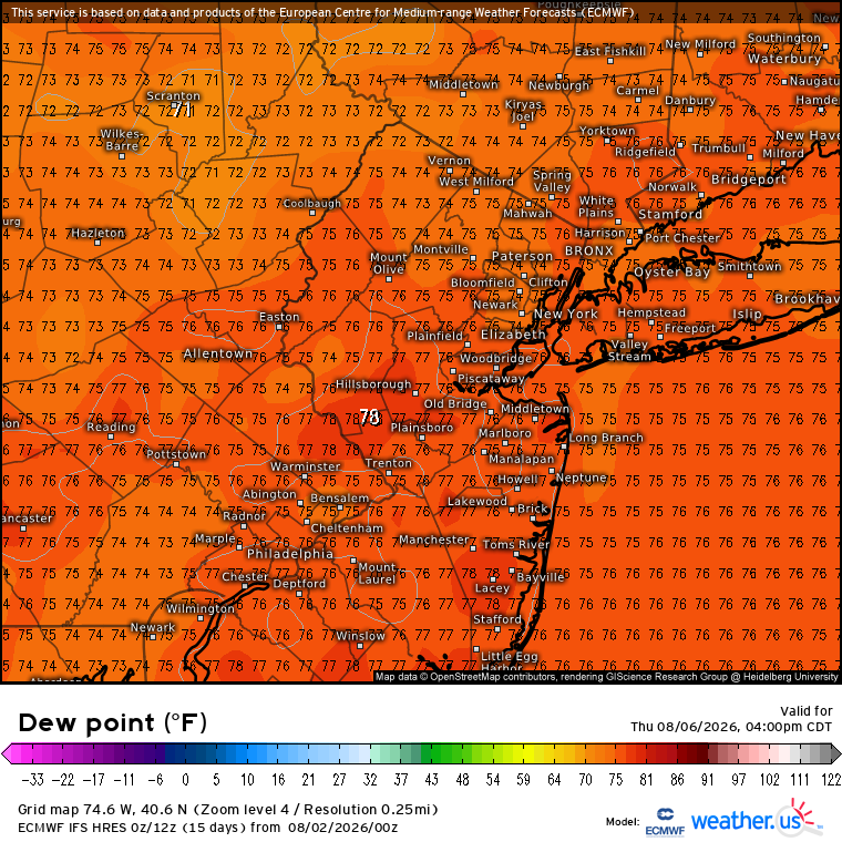
Yep. Muggy Meter shows it well.
.thumb.png.8016b1f82394cb86aa02cc0d42ccc221.png)
-
Nice steady rain this morning...lovely
-

Augdewst 2026: Summer's Last Stand
CoastalWx replied to Prismshine Productions's topic in New England
One day dew down then it comes right back. They’ll be some shwrs and storms around but it should be a very warm week overall with plenty of sun. -
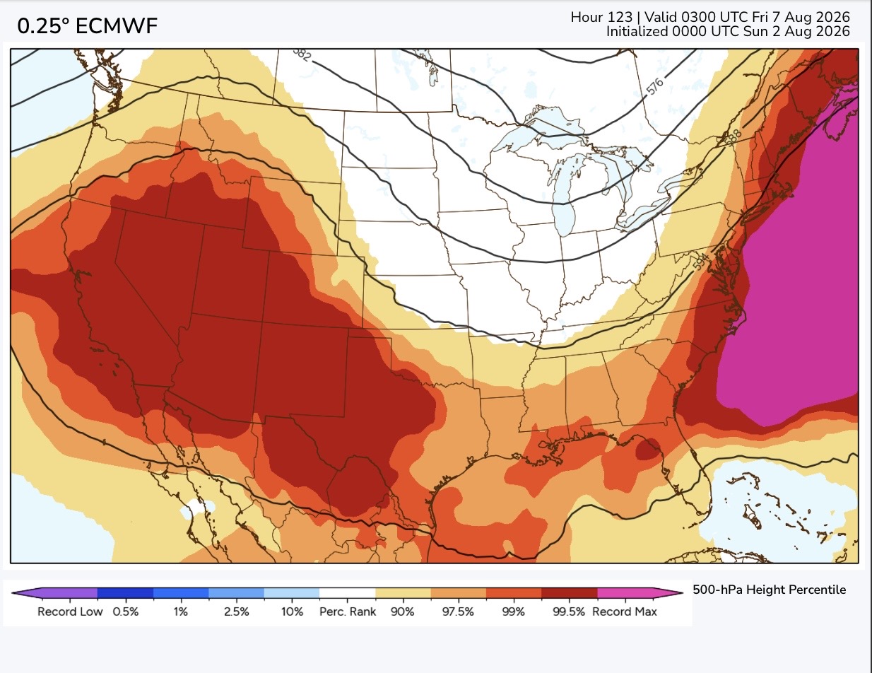
Looks like we could see a record ridge approaching 600 DM to our east by later this week. So probably more 90° potential. Could also be our highest dew points of the summer so far from the mid to upper 70s.
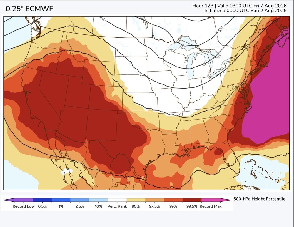
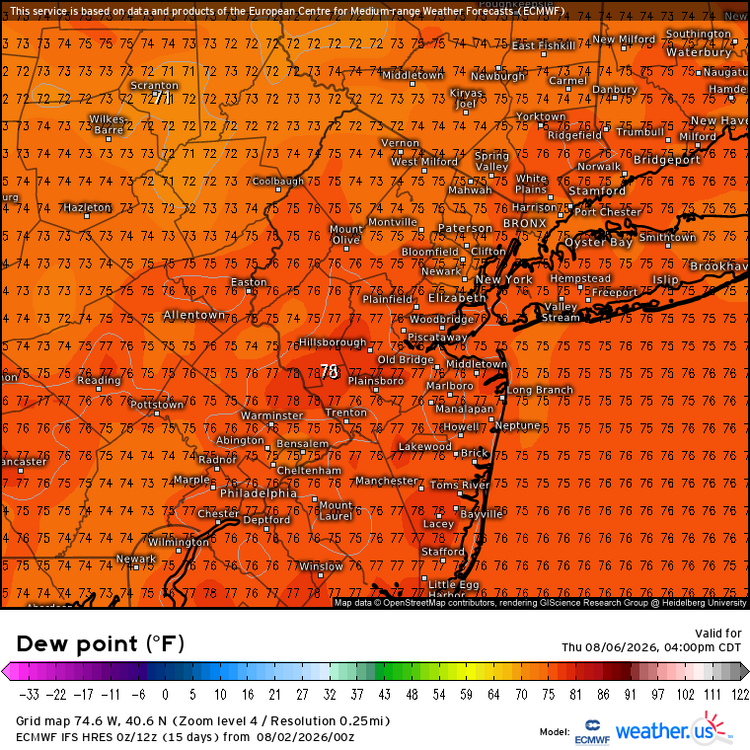
-

2026-2027 Super El Nino
rclab replied to Stormchaserchuck1's topic in Weather Forecasting and Discussion
I feel, MN, that your first sentence speaks more of frustration than contention. My understanding of the atmosphere is less than fragmentary when compared to the well versed members of our forum. To give a simple answer in predicting the behavior of our atmosphere may be thought of as courageously assertive or assertively foolish. I do agree with your law school instructors admonition. Could such a ‘brief and to the point’ desire be applied to judicial decisions in our courts. Perhaps only to a jury with just a one or two word answers to a judge’s final question. Please don’t take exception to what I’ve write. I want to thank you for giving what grey matter I have left, some exercise. As always -

E PA/NJ/DE Summer 2026 Obs/Discussion
Psychguy replied to PhiEaglesfan712's topic in Philadelphia Region
True… I believe we only had a few more days in August that went into the 90’s. But overall August was much cooler. -
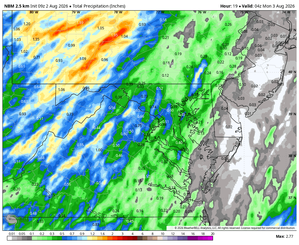
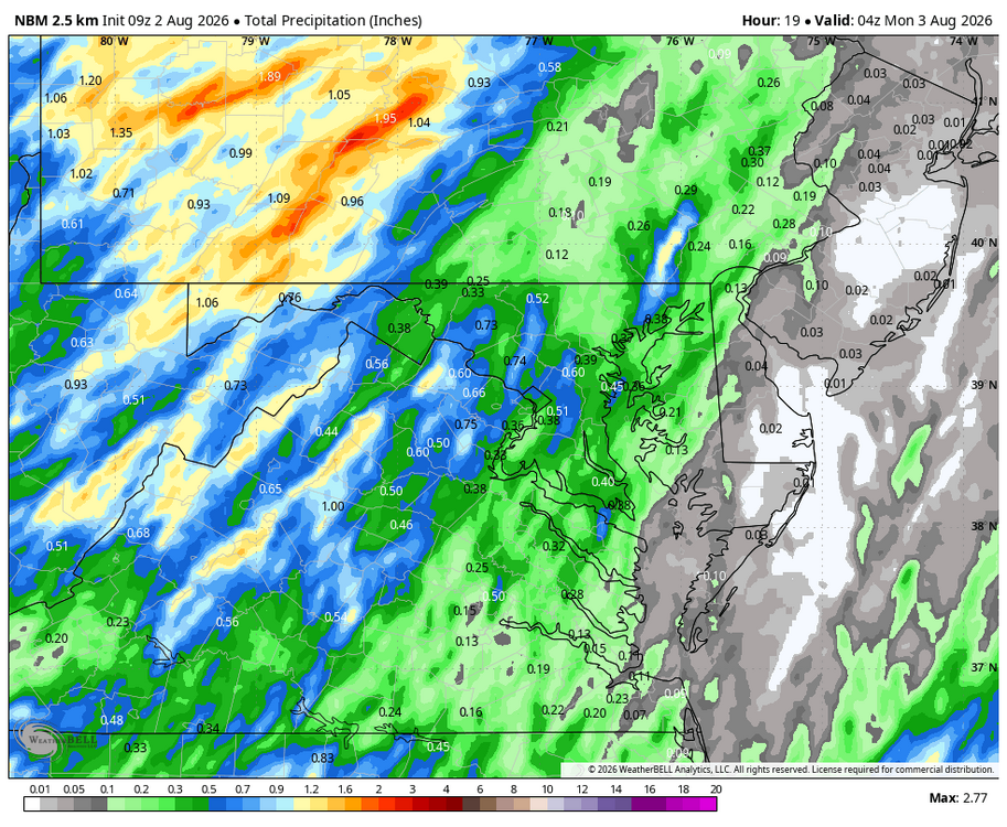
Congrats to the west. It looks like a steady stream of heavy rain along the Blue Ridge. It's been since January since I've seen a juicy radar. Unfortunately that was sleet and 19 degrees lol
-
WB 9Z NBM for today.
-

2026-2027 Super El Nino
bluewave replied to Stormchaserchuck1's topic in Weather Forecasting and Discussion
First, let’s get something straight right now. The weather and climate isn’t law school. Trying to reduce weather patterns to some type of legalistic definition isn’t going to fly. All we can say is beyond two weeks is that the models lose skill. But they have been making errors in certain types of ways. One is to underestimate the magnitude and even location of the ridges. The other is that the troughs have been verifying weaker. We are currently heading into a super El Niño without precedent. First, the strength is going off the scale. Second, the 500 mb weather patterns are currently in more of -PDO +AMO pattern. This has never happened before. So it’s probably a reasonable guess at this early point that the ridges during the winter will continue verify stronger than the model forecasts like that have most winters over the last decade and the troughs weaker. If you want the exact locations now, then I think you are being unrealistic. Especially since the 500mb pattern is yet to take on a more traditional pattern. So we are going to have to wait and see how close or different the pattern develops going forward. So even if a 10%-20% Niña-like mid-latitude ridge enhancement continues into the winter, it could lead the El Niño ridge pressing further south and east than usual. - Today
-
order viagra [url=https://medmennews.xyz/#]Med Men News[/url] Generic Viagra online
-
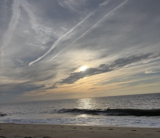
Morning is fine on the shore....
-
2026-2027 Super El Nino
mitchnick replied to Stormchaserchuck1's topic in Weather Forecasting and Discussion
Can't you ever answer a simple question with a simple answer? When I was in law school, they beat into our heads: be brief and to the point. I didn't ask if any models should be taken at face value. I asked if" the ridges will be or won't be stronger and thereby causing current seasonal modeling for the southeast, mid atlantic, and/or northeast to be wrong?" So, do you or don't you? Because right now, your statements are nothing more than "could be." Which leaves them open to you claiming victory if they are stronger and defending the statements if they aren't by saying "I said could be." -
Viagra Tablet price: MedMenNews - Cheap Viagra 100mg
-

Central PA Summer 2026 Discussion/Obs Thread
mahantango#1 replied to Voyager's topic in Upstate New York/Pennsylvania
Hot time summer in the city. -
"By Tuesday the trough axis moves into the maritimes and mid level ridging/building surface high pressure should keep rain at bay for the most part. Uncertain as to exactly when our next bout of unsettled weather arrives but the synoptic pattern looks to be active, so periodic shortwaves (rain/t-storm chances) are expected to move through mid to late week, and even continuing into the weekend for daily afternoon/evening rain chances." If I wanted Vermont summer weather I would move to Vermont. Waste of a summer week.
-
Overcast, sprinkles, 70 dewpoint. Disgusting. Fall can't come soon enough. Don't know why, but muggy air always feels dirty to me, no matter what the air quality - and the lower the dewpoint, the cleaner and fresher it feels, even with wildfire smoke!! (I think it might date back to when I was a kid at summer day camp. I had to join in with strenuous athletic activities in the worst of the Northern Virginia summer, and my mother would always dress me too warm, in dark colors, so of course I got prickly heat and was pouring with sweat; to this day I despise the smell of wet grass for the same reason. And my house didn't have air conditioning back then either!)
-
2026-2027 Super El Nino
bluewave replied to Stormchaserchuck1's topic in Weather Forecasting and Discussion
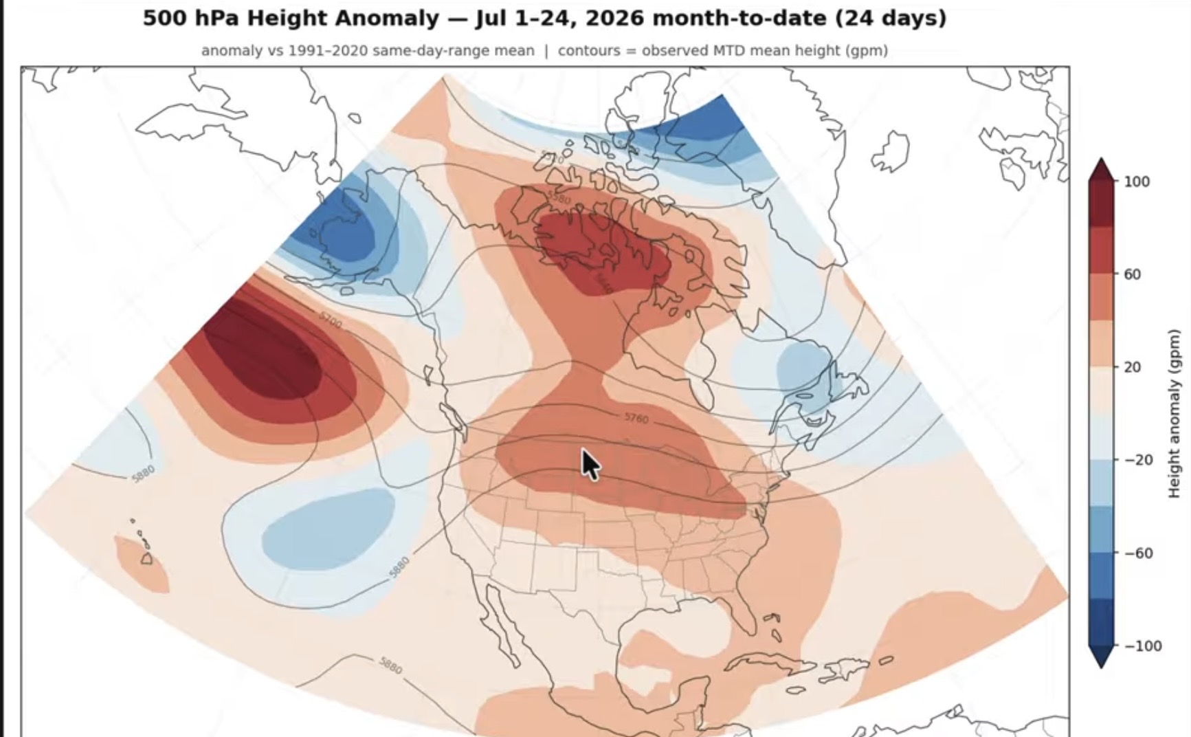
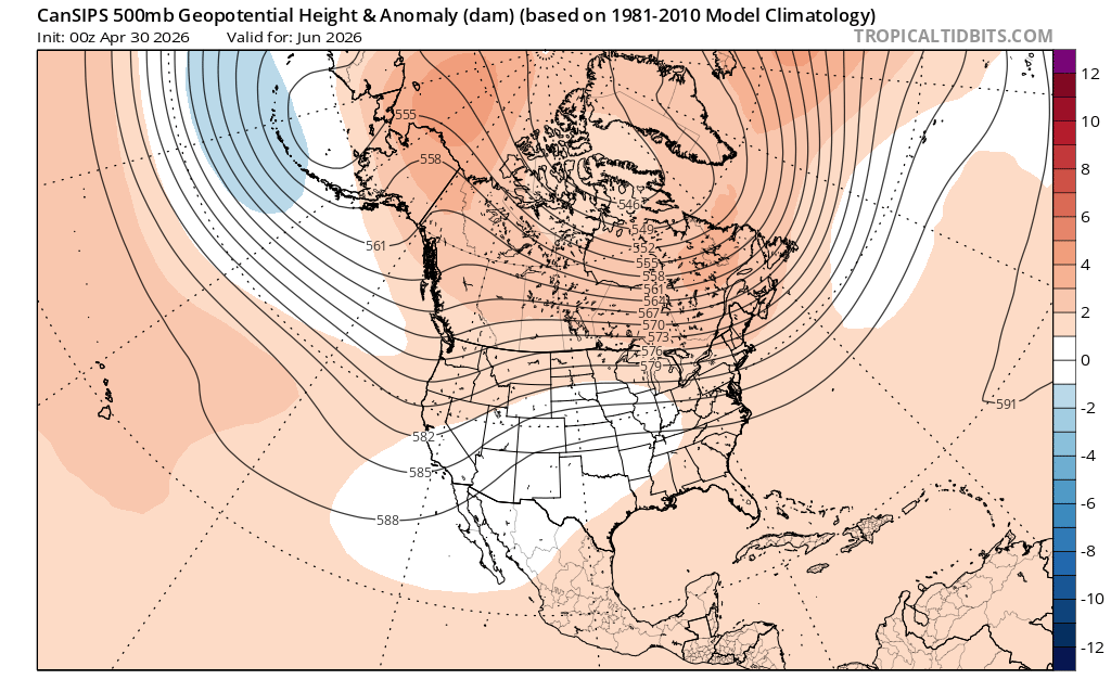
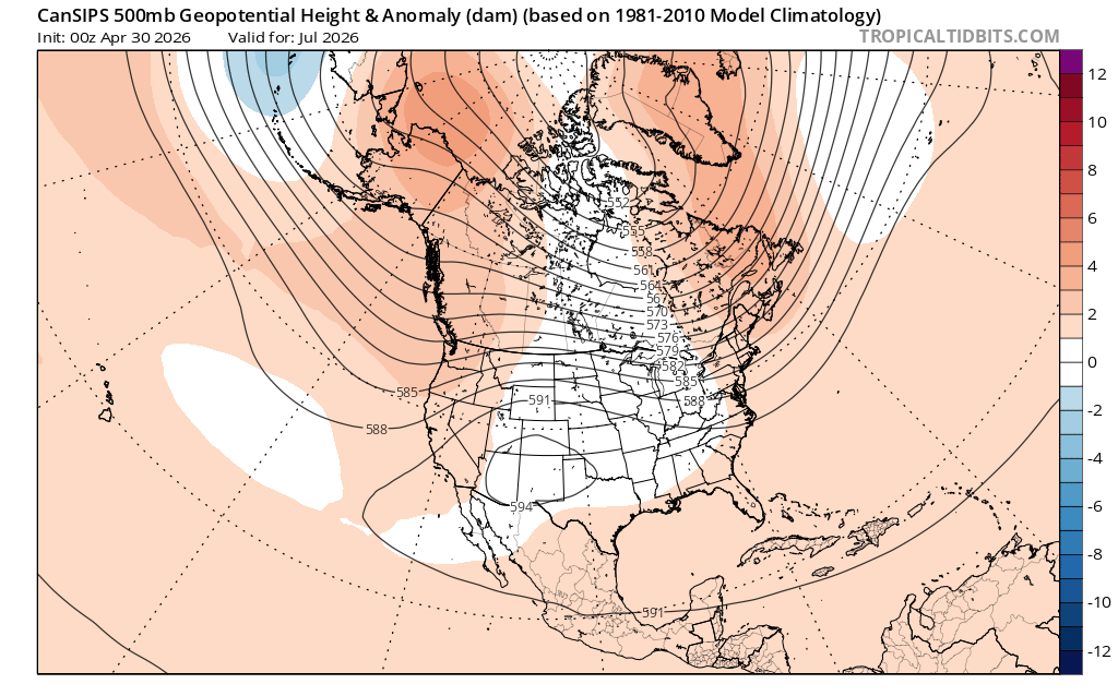
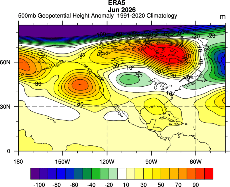
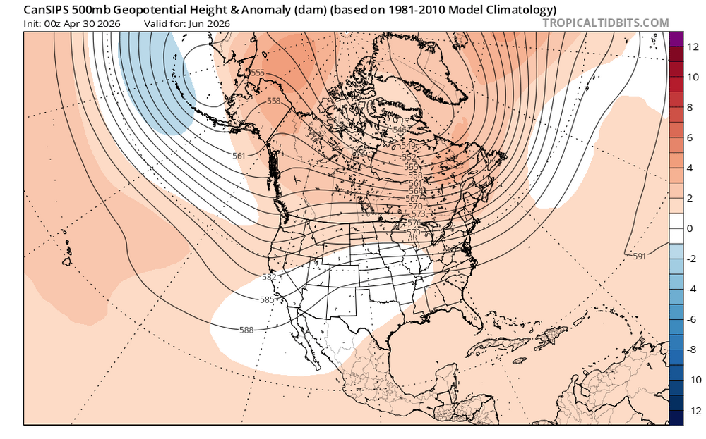
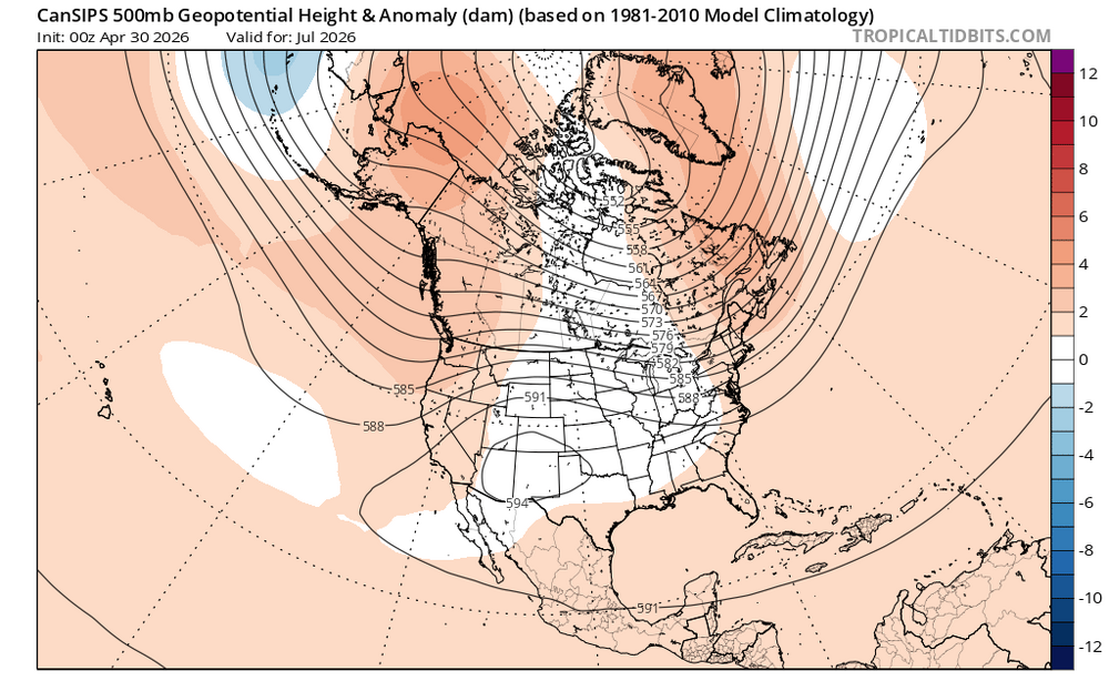
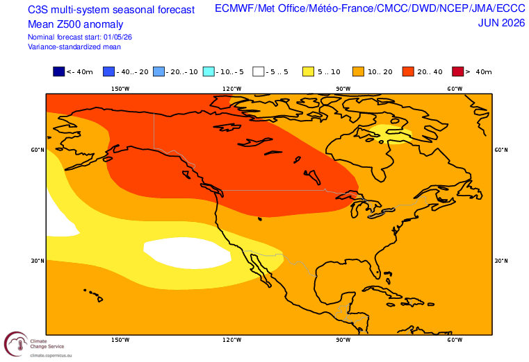
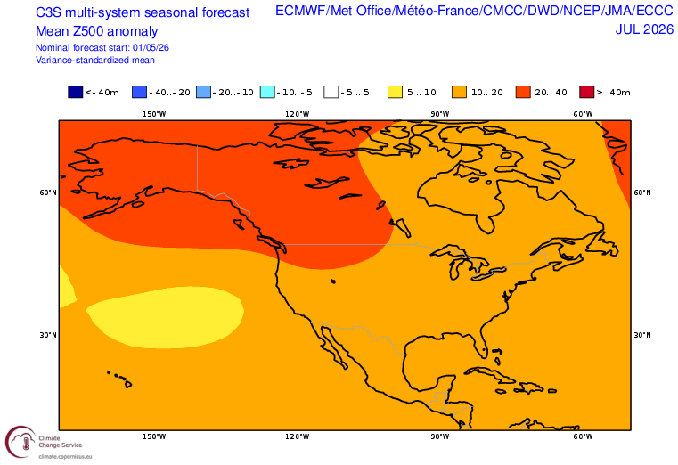
How can anyone take the seasonal models at face value for the winter which is 4-6 months away when the May forecast for this June and July only 1-2 months out had such significant errors? This is another example of the models not having much skill beyond the 15 day period. Notice how the ridges in the mid-latitudes verified much stronger leading to the strong -PDO +AMO pattern. The forecasts were going for a general Nino 3.4 correlation which didn’t work out. So it looks like the models are just defaulting to Nino 3.4 climatology for June and July. Back in 2023-2024 the winter forecasts also defaulted to general Nino 3.4 correlations with the ridges verifying much stronger and the troughs weaker. Forecasts from around May 1st June Forecasts June correlation for Nino 3.4 June verification July forecasts July correlation Nino 3.4 July verification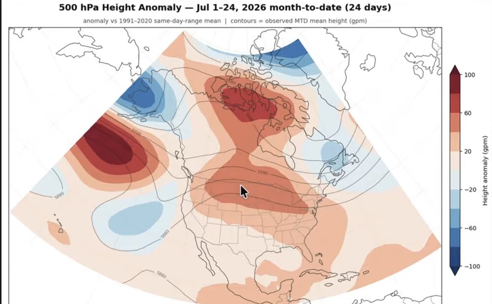
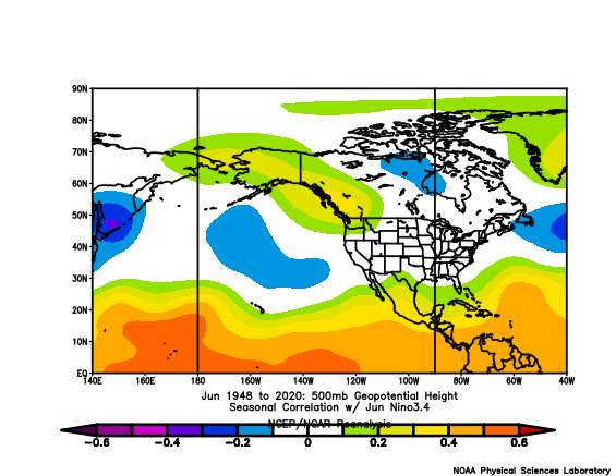
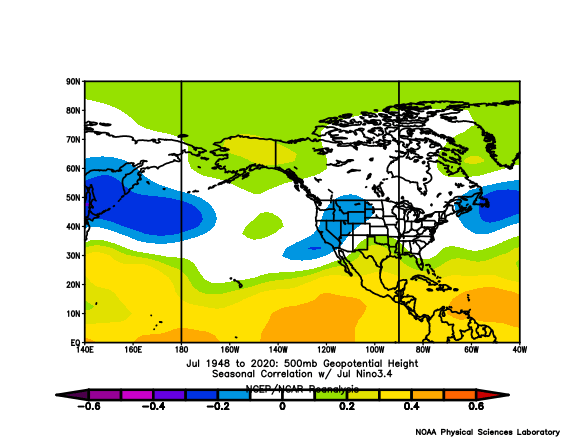
-
Cheap Sildenafil 100mg: Med Men News - generic sildenafil




.png.ea81933c0c3601e492694d3ac2231fd5.png)