All Activity
- Past hour
-
I know what you’re trying to imply.
-
 Insane rain. Station over 2” now
 -

2025-2026 Fall/Winter Mountain Thread
Maggie Valley Steve replied to Buckethead's topic in Southeastern States
What a raw wet day in the Valley. Temperature started out in the upper 30’s and has managed to 'heat up' to the mid and upper 40’s this afternoon. GSP stated in their afternoon disco that the freezing levels are beginning to drop rather quickly and a good chance for snow showers from 3500 ft and the possibility of some light accumulations. -
.30 rain today, misty and foggy this afternoon. High was at midnight, the temp has been steady around 45 this afternoon.
-

Central PA Fall Discussions and Obs
pawatch replied to ChescoWx's topic in Upstate New York/Pennsylvania
1.97 “ of rain and still some rain showers. Much needed…. -

Spooky Season (October Disco Thread)
ineedsnow replied to Prismshine Productions's topic in New England
At market basket in Athol and actually getting some good gust -
Still wondering about this. Why did you criticize the national temperature map for "only including March to August" when you previously posted/backed a map which only included January 1st-February 21st?
-
Line is just about thru here, just heavy rain, no wind. looks like it could be backfilling with the latest radar return.
-
 Heavy rain but bizarrely calm winds. It's dead calm.
 -
 2.09 Staten Island north shore.
 -
 Mesoscale Precipitation Discussion 1220 NWS Weather Prediction Center College Park MD 332 PM EDT Thu Oct 30 2025 Areas affected...northern NJ into southern NY/Long Island and CT Concerning...Heavy rainfall...Flash flooding possible Valid 301931Z - 310125Z Summary...Heavy rain across the Tri-State Area through this evening may result in localized flooding/flash flooding. Localized rainfall totals over 3 inches will be possible. Rainfall near 1 inch in 15-30 minutes can be expected. Discussion...19Z radar imagery showed a low-topped squall-line, oriented from south to north, edging east from 40 miles east of ACY through NYC. This line was being aided by strong low level convergence with 45-50 kt from the SSE/SE in the 925-850 mb layer, located north of the triple point of an occluded cyclone over the northern Mid-Atlantic region. The line of showers has been accompanied by 0.50 to 1.00 inches of rain in 15 minutes across northern NJ into the Five Boroughs. Moisture from the Mid-Atlantic coast into southern New England was already anomalous as sampled by area 12Z RAOBs, with PWAT values of 1.2 to 1.5 inches. However, OSPO's ALPW has since shown an increase stemming from Melissa's circulation, especially near and below 700 mb, being drawn northward into NJ and southern NY. The continued addition of this remnant tropical moisture should allow for an increase in rainfall efficiency and locally higher rainfall rate potential into the early evening hours. While the line of showers has been progressive, there is some concern for very brief slowing/stalling given the LEWP-like appearance off the NJ coast, which could result in a quick 1-2 inches as this line continues to advance east through the remainder of the afternoon. As a triple point low becomes better organized south of Long Island this evening, low level flow will maintain a southeasterly orientation, with possible backing. Therefore, some orographic component to lift will be added into the equation for the higher terrain north and west of I-95, combining with increasing right-entrance jet ascent associated with a forecast 130 kt jet streak on the east side of the parent upper low to the west. Farther south and west, instability is expected to remain weak (briefly peaking in the 500-1000 J/kg range) but perhaps sufficient to support a few additional heavy showers from eastern PA and southern NJ, rotating northward into the Tri-State region. Additional rainfall may result in isolated areas of rapid inundation of water. Given below average rainfall over the past few weeks and ongoing drought conditions across portions of the region, any flooding that occurs is likely to remain constrained to urban or other areas with poor drainage. Otto
 -
.thumb.png.4150b06c63a21f61052e47a612bf1818.png)
Spooky Season (October Disco Thread)
HIPPYVALLEY replied to Prismshine Productions's topic in New England
Fortunately, this is happening tonight and not Halloween night. Blah day, but hardly any rain in Greenfield today. A few light showers this morning. -
I've seen lots of mentions about the TNH, and I'm not really familiar with that. Can somebody explain how it works, and how it will affect us for winter (e.g. -TNH vs +TNH)?
-

Event Discussion-OBS uncertain tracking thread for possible moderate impact event 8A Thu-8A Fri 10/30-31. Mainly 1-3" rains, G 45-55 MPH-mainly coast, and high prob of at least minor coastal flooding - Thursday afternoon high tide cycle.
hudsonvalley21 replied to wdrag's topic in New York City Metro
Rain rate of 3.56” currently. 1.77” so far. -
1.32" now and that line, which isn't as bad up here, has moved through.
-
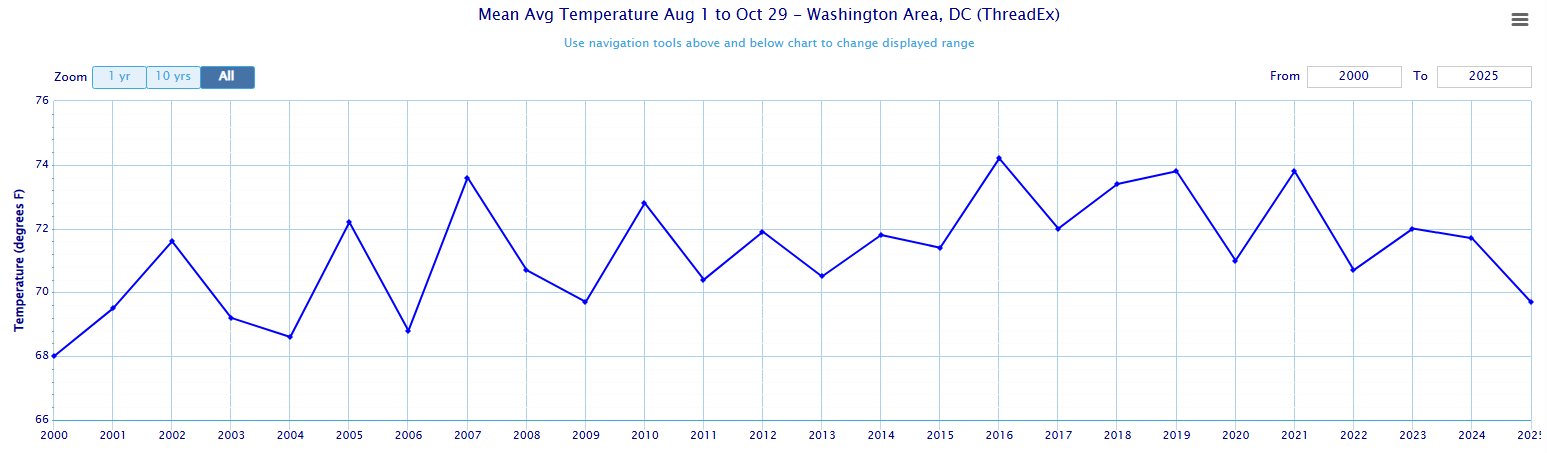
The period starting August 1st through now is tied with 2009 for the coolest such period since 2006 at DCA, with an average temperature of 69.7 Degrees. T-6th Coolest in the last 25 years, though it falls to T-17th Coolest in the last 50 years.
-
Current rain rate is 3.56” total as of 3:45 is 1.77”
-

E PA/NJ/DE Autumn 2025 Obs/Discussion
The Iceman replied to PhiEaglesfan712's topic in Philadelphia Region
Humidity outside is actually crazy with how chilly it was earlier. Picked up about 1.1" on the event. -
 Holy crap, around noon time, Newark only had 0.75" (the NWS is only showing 1.15" for Newark airport?) We did get some heavier downbursts after 12 pm to about 2 PM. No flooding in the immediate area. But looks like NYC received a heavier band that was somewhat training over the area...
 -
 At 230 I saw the radar and picked up the kids from school early. Sometimes its good to be in the know haha At least this was relatively short. If there was more behind, we would have big problems
 -

Major Hurricane Melissa - 892mb - 185mph Jamaica landfall
Krs4Lfe replied to GaWx's topic in Tropical Headquarters
I wonder what the observations will be like from east Newfoundland tomorrow night, and Saturday, looks like it’ll have just transitioned to a post-tropical, hurricane force low pressure by then. -

Spooky Season (October Disco Thread)
WxWatcher007 replied to Prismshine Productions's topic in New England
NYC getting smoked right now -
That's almost always debatable. The rain is "showery" in nature. Most of the day featured on and off showers, mainly light in nature, with some heavier downpours. But, depending upon your exact location, you may have had more persistent heavier bursts. Certainly Northeastern PA was a bullseye, as forecast. Seems like your area was another bullseye. We had a snowstorm, I think within the last 10 years that was extremely spotty, some areas getting 20"+ and other areas 5", from town to town. I can't remember a snowstorm that was that "convective" before. Then within a week or so later, another snowstorm was forecast. Storm Field was predicting the exact same thing, extreme variations in totals, as though suddenly this was a new trend. The snowfall amounts in the 2nd storm were much more uniform.
-
.HYDROLOGY... -- Changed Discussion -- Instantaneous rainfall rates with a narrow convective line moving through attm have come close to an inch in only 10 minutes in parts of NYC, with storm totals over 2 inches, causing flash flooding in spots. Widespread rainfall of 1.5-2.5 inches expected through tonight, with widespread nuisance flooding likely. Local amts as high as 3-4 inches, and rates up to an inch in less than an hour, will also present a localized flash flood risk mainly from western CT/Long Island north/west. -- End Changed Discussion --
- 166 replies
-
- 1
-

-
- heavy rain
- damaging wind? squalls?
- (and 2 more)
-
After 3 days of clouds and drizzle the sun finally came out. Ended up with 1.26" for the 3 days. Warmed up to 71 today.