All Activity
- Past hour
-
Received my first misquito bite of the season on the golf course Sunday. Got me on the calf before I could swat it away. Guess from now until November I will need to be all sprayed up...
-
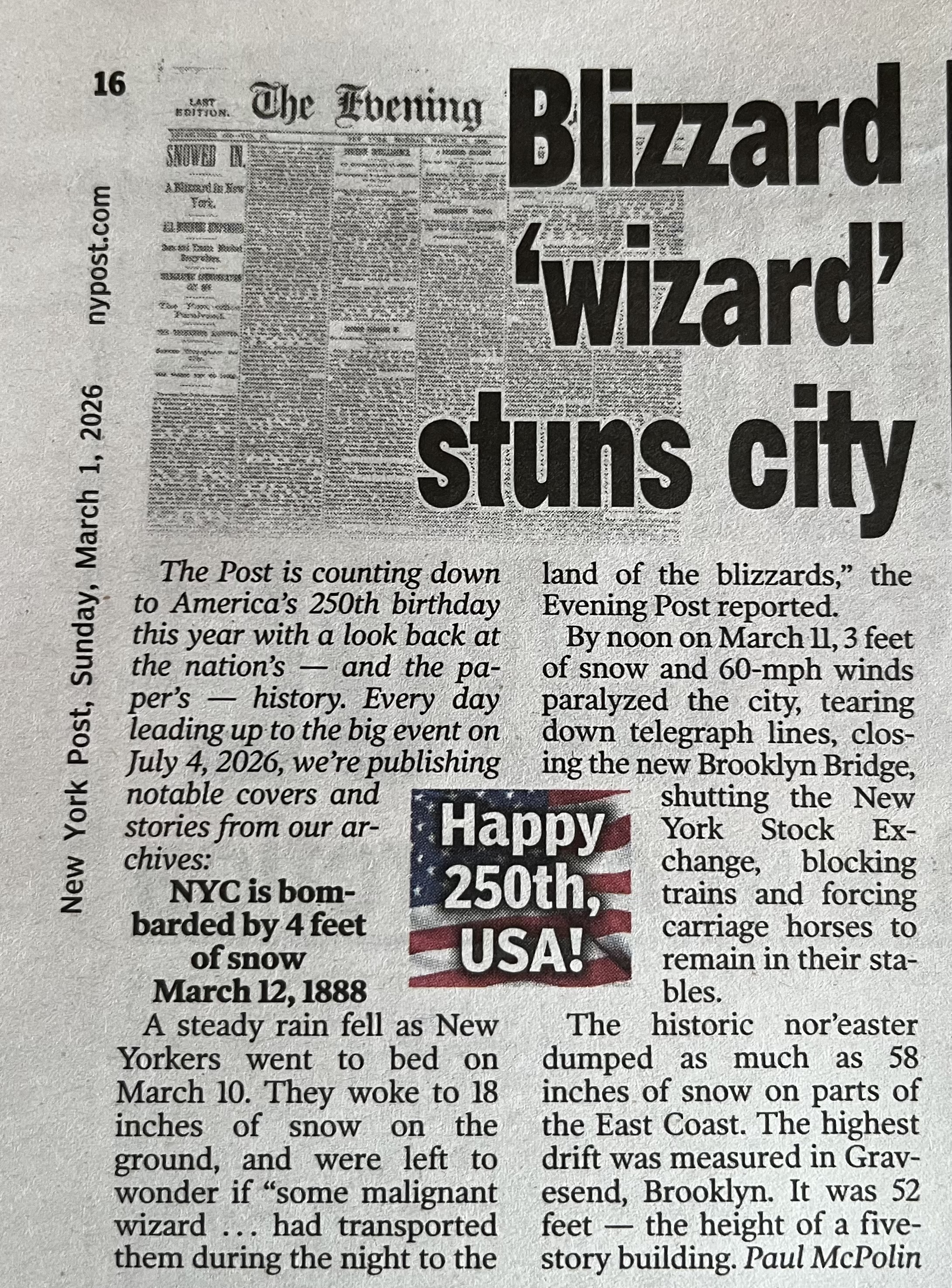
This was in Sunday’s Post, one can only hope lol
-
Records: Highs: EWR: 70 (2024) NYC: 68 (2024) LGA: 68 (2024) JFK: 68 (2024) Lows: EWR: 9 (1950) NYC: 11 (2003) LGA: 10 (1950) JFK: 12 (1950) Historical: 1896: The temperature in downtown San Francisco, California, fell to 33 degrees, which was the lowest ever for the city in March. 1942: Asheville, NC picked up 15.8 inches of snow to establish their 24-hour snowfall record. (Ref. Wilson Wx. History) 1947: Vermont and northwestern Massachusetts had their biggest snowstorm in this century when Readsboro, in southern Vermont, received 50 inches in 3 days, and Peru, in northwestern Massachusetts, received 47 inches in 3 days. (Ref. Wilson Wx. History) 1953: Oahu, Hawaii: Snow falls on the island of Oahu. (Ref. WxDoctor) 1960: Eastern Massachusetts' greatest March snowstorm occurred from this date through the 5th. The storm produced record 24-hour snowfall totals of 27.2 inches at Blue Hill Observatory, 17.7 inches at Worcester, and 16.6 inches at Boston. Winds gusted to 70 mph. (Ref. Wilson Wx. History) 1960: NYC: 14.5 inches of snow, EWR: 13.9 inches of snow. 1966 - A tornado hit Jackson, MS, killing 54 persons. (David Ludlum) 1966: An F5 tornado, which would become known as the “Candlestick Park” tornado, named after a shopping center in south Jackson, was destroyed by the tornado. One of only two documented F5 tornadoes to strike Mississippi in the 20th century. The worst damage occurred in parts of Hinds, Rankin, Scott, and Leake counties, where 57 people were killed and over 500 were injured. 1971: An extremely intense coastal storm blasted the northeastern U.S. and continued into the 4th. The barometric pressure dropped to 960 millibars or 28.36 inches of mercury at Worcester, MA for the lowest pressure ever recorded at the location. The same record was set at Concord, NH with a reading of 963 millibars or 28.44 inHg. Wind gusts 70 to 100 mph lashed eastern New England with major wind damage. Tides ran 4 to 5 feet above normal resulting in extensive coastal flooding. (Ref. Wilson Wx. History) 1980 - A coastal storm produced 25 inches of snow at Elizabeth City, NC, and 30 inches at Cape Hatteras NC. At Miami FL the mercury dipped to 32 degrees. (Sandra and TI Richard Sanders - 1987) 1983 - The last of a series of storms to strike the California coast finally came to an end. Waves fifteen to twenty feet high pounded the coast for two days, and in a four day period up to 18 inches of rain drenched the Los Angeles and Santa Barbara area. On the morning of the first, thunderstorms spawned two tornadoes which moved through the Los Angeles area. (Storm Data) 1987 - A storm brought heavy rain and gale force winds to Washington and Oregon. Quillayute WA received 2.67 inches of rain in 24 hours, and winds gusted to 60 mph at Astoria OR. (The National Weather Summary) (Storm Data) 1988 - A small but intense low pressure system roared across west central Mississippi at 90 mph early in the morning. A tornado in southern Mississippi picked up an automobile, carried it 150 feet, and tossed it through the brick wall of an unoccupied retirement home. (The National Weather Summary) (Storm Data) 1989 - Wintry weather prevailed from the southern Rockies to the Upper Great Lakes. Neguanee MI received 19 inches of snow, and up to 24 inches of snow blanketed Colorado. Blizzard conditions were reported in Minnesota. (The National Weather Summary) (Storm Data) 1990 - An upper level weather disturbance produced snow in the Colorado Rockies, with eight inches reported at Winter Park, and a storm moving off the Pacific Ocean began to spread rain and snow across the western U.S. March continued to start off like a lamb elsewhere around the country. (The National Weather Summary) (Storm Data) 1991: A significant ice storm coated parts of central and northwestern New York State with up to two inches of ice. The damage totaled $375 million. It was the most costly natural disaster ever in the state up until that time. Nearly half a million people were without power at the height of the storm, and many would not see their power restored until the 16th. 1994: Deep low tracks east coast, 20-30 inches of snow in western VA, Dove, DE wind gust to 70 mph and severe coastal erosion, seas 25 feet off of Hatteras, NC another one to two feet of snow from WV to New England. (Bob Ryan's 2000 Almanac) A major coastal storm was in progress over the mid-Atlantic and the northeast. Winds gusts hit 75 mph at Dover, DE. Big snows buried interior sections. Two day snowfall totals 33 inches at Burdett, NY, 30 inches at Frankfort Center, NY, 29 inches at Loganton, PA, 26 inches at Jay Peak, VT, and 22 inches at Frostburg, MD. The 8.7 inches of snow at Allentown, PA raised their seasonal snowfall to 69.2 inches for their snowiest winter ever. Boston's 8 inches pushed its seasonal snow to 89.5 inches for their snowiest winter as well. The maximum 24-hour snowfall total for the state of Virginia was set today with 33.5 inches at Luray , Virginia on March 2-3, 1994. (Ref. Wilson Wx. History) 2003 - It was a day of temperature extremes. Miami reached a high temperature of 90 degrees, the earliest observed 90 degree temperature since March 5, 1964. Meanwhile Marquette, MI, dropped to 30 degrees below zero, the lowest temperature ever recorded in the city in March. 2016: A deadly severe weather event affected the Southeastern United States on March 3, 2019. Over 6 hours, 41 tornadoes touched down across portions of Alabama, Georgia, Florida, and South Carolina. The strongest was an EF4 tornado that devastated rural communities from Beauregard, Alabama, through Smiths Station, Alabama, to Talbotton, Georgia, killing 23 people and injuring at least 100 others. Click HERE for more information from the NWS Office in Birmingham, Alabama.
-
Interesting Madison sits at 41.5" while RFD at 24" considering the eastern trough pattern dominating a lot of the winter. That 70 miles shows up significantly in seasonal averages. RFD at 37" vs 50" for Madison. They even exceed Milwaukee seasonally which seems odd given MKE LES potential to fluff up totals.
-

Winter 2025-26 Medium/Long Range Discussion
hawkeye_wx replied to michsnowfreak's topic in Lakes/Ohio Valley
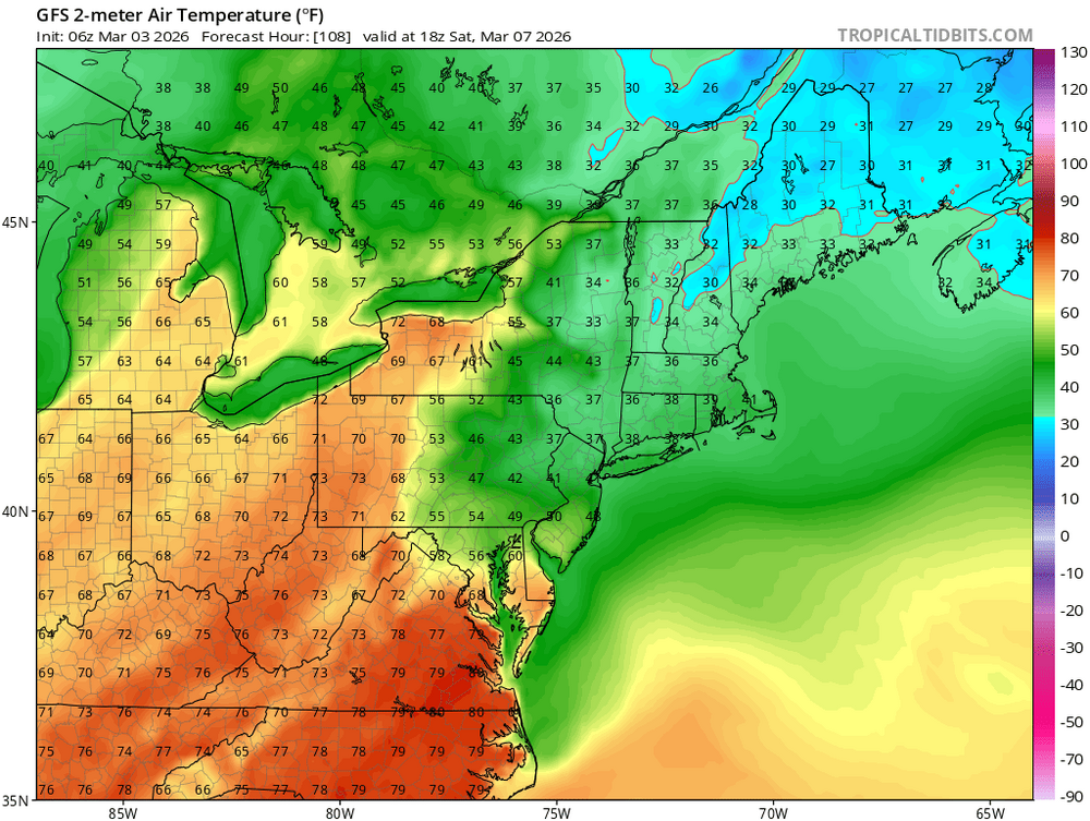
Last night's Euro has a high of 80º+ next Tuesday ahead of a strong cold front, with a few pockets reaching the mid 80s, before the pattern turns much colder. -
Summers have gotten shorter with all the bogus cancellations for a minor winter event not to mention all the holidays they have added in recent years
-
They do towards the last week of June... unless it is too hot... or too smokey from wildfires... or it the day ends in a "y"...
-
February was a shit show with some places off a week for Feb break and then the blizzard and today's mess
-
Forecast up to 2-4 here. Hit -12 overnight, probably a 40+ diurnal range today. Currently pure blue skies.
-
It has been an A+ year for winter here at my location. We ended up with 16.5 inches of snow for the season. The December snows back to back really got things started with a bang. Here's to hope for an exceptional season with ample snowfall for all next winter.
-
3/2 was this the coldest day till next season? EWR: 32 / 21 (-11) NYC: 33 / 21 (-12)
-
35 / 30 here with mainly rain now after sleet earlier. Warm up ramp up starting Wed 50s , Sun 60s , and by Tue 70s for some (first since Oct). Overall warm to much warmer and wet (wettest days today / Thu) . With the warmth comes mainly cloudy days with perhaps a break and the nicest stretch 3/9 - 3/11. Beyond there back towards and below normal 3/13 - 3/19.
-
Would love to see a redux of this
-
.thumb.png.991e09c19c25af7391ed569a205a5136.png)
E PA/NJ/DE Spring 2026 Obs/Discussion
Blue Dream replied to PhiEaglesfan712's topic in Philadelphia Region
It snowed for about 5 minutes before changing to rain lol. -
Hopefully NOVA stays on the warm side of the BDCF.
-
Do kids go to school anymore in SNE?
-
Depth 15.5 Water Equivalent 2.71
-
Over reaction to closings around Seymour? Still can’t believe we closed. .
-
Started as a sleet/snow mix, never all snow. 31.2⁰ and 90% rain now
-
Sleet falling in Clifton, Nj
-
And three or four days later…
-

Outta gas and Outta Time: Early March Winter Storm finale
Harv_poor replied to Ji's topic in Mid Atlantic
I know last week there was a discussion about the total new snow reporting at Wintergreen. Yesterday, their Devil’s Knob camera ( golf course on top of mountain) showed the ground going from clear to snow covered, even the walkways. The three ski trail cameras also showed snow falling. Grass is still snow covered this AM but there is no new snow being reported. I think Devils Knob is the highest golf course in Virginia. -
Bright sun and 25° here near KBED. Hard to believe in 3 hours it'll be snowing....
-
Wow-really dumb
-

Central PA Spring 2026 Discussion/Obs Thread
pasnownut replied to Voyager's topic in Upstate New York/Pennsylvania
One thing of note this year is that Op guidance seemingly has done pretty well vs longer lead ENS guidance, so hey, maybe once again, this has a chance. Verbatim what you've shared would be "anomalous enough". Lol