All Activity
- Past hour
-

1/24-1/25 Major Winter Storm - S. IL, IN, MI and OH
A-L-E-K replied to A-L-E-K's topic in Lakes/Ohio Valley
not even a decade in the rearview, lots of clunkers seasons to go before we're due again -

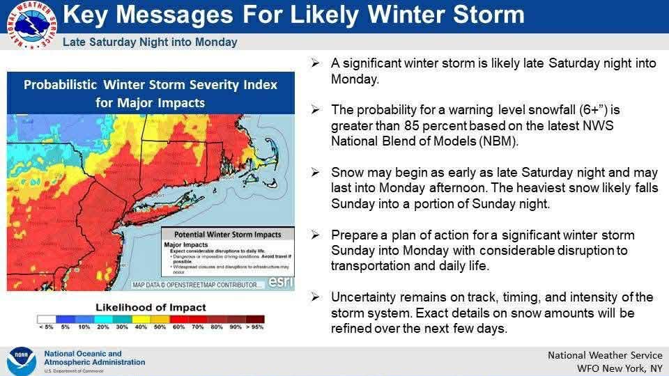
Possible Record Breaking Cold + Snow Sunday 1/25 - Tuesday 1/27
MJO812 replied to TriPol's topic in New York City Metro
-
It rained.
-
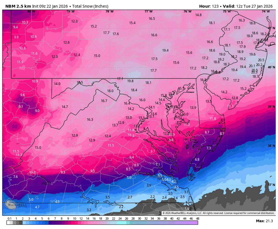
2.25” at my place. Stat padder that will melt away
-

“Cory’s in LA! Let’s MECS!” Jan. 24-26 Disco
40/70 Benchmark replied to TheSnowman's topic in New England
May not end up the worst map in the world -

January 24-26: Miracle or Mirage Thread 2
SomeguyfromTakomaPark replied to mappy's topic in Mid Atlantic
Also waking up to NWS talking about 15 or 18 to 1 ratios with the snow initially. It’s gonna pile up fast. -

Possible Record Breaking Cold + Snow Sunday 1/25 - Tuesday 1/27
Tatamy replied to TriPol's topic in New York City Metro
Look at the temps at 700mb and 850mb. It gives a different picture of the event precip wise. Be sure to look at 96 and 102 hours. -
 does anyone know how accurate the NBM is?
 -
Possible Record Breaking Cold + Snow Sunday 1/25 - Tuesday 1/27
MJO812 replied to TriPol's topic in New York City Metro
Alot of storms back in the day use to end as sleet especially near the coast -

1/24-1/25 Major Winter Storm - S. IL, IN, MI and OH
buckeye replied to A-L-E-K's topic in Lakes/Ohio Valley
dude....cincy and towns along the ohio rive are ground zero for big snows west of the apps. If we get 6-10 you guys are easily 12+ -
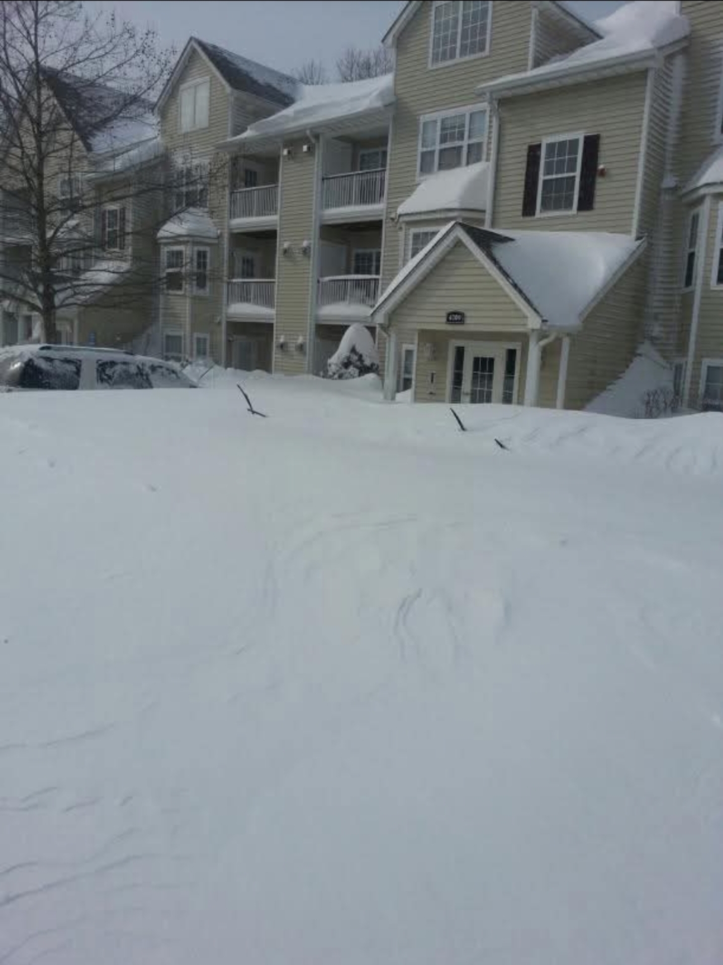
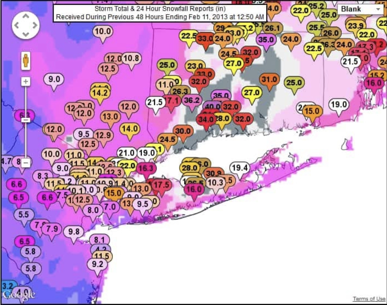
Maybe Feb 8th 2013. My sister sent me this from her apartment in Hamden that recorded 40 inches.


-
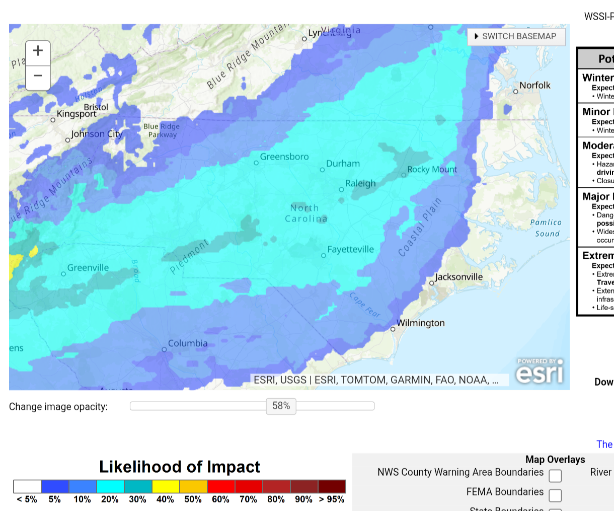
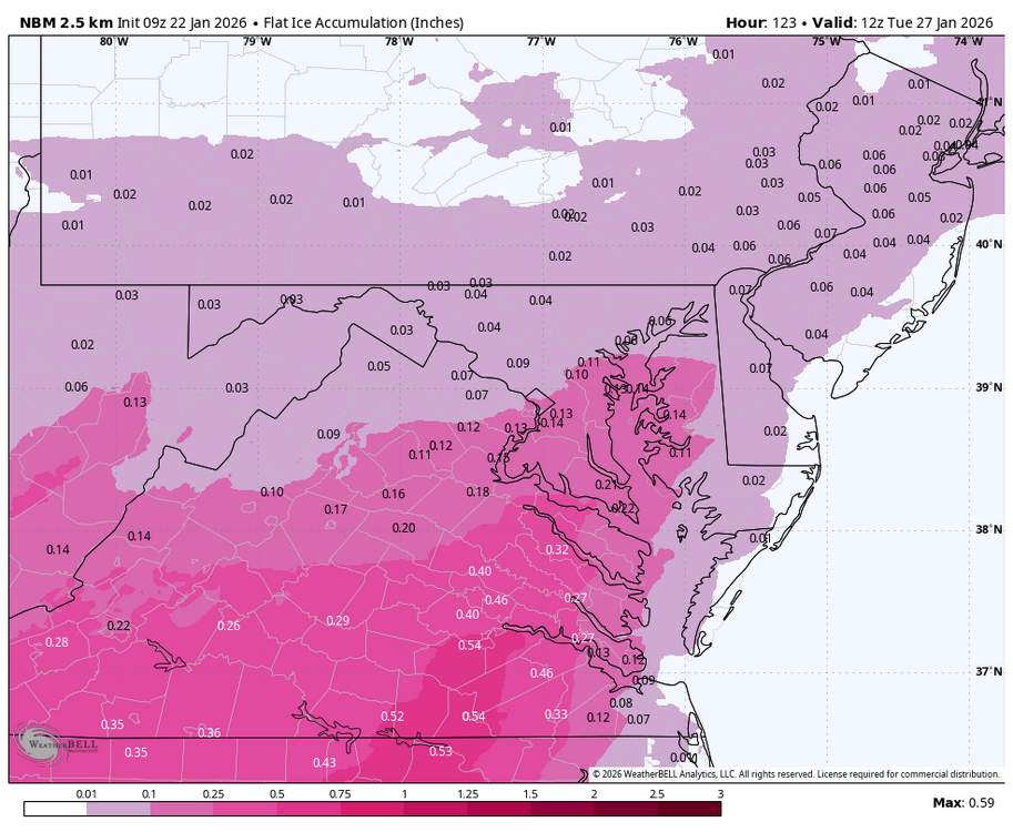
Chance of major ice impacts

-
Wish it wouldn’t get into upper 30’s today. Brief thankfully
-

Pittsburgh/Western PA WINTER ‘25/‘26
jwilson replied to Burghblizz's topic in Upstate New York/Pennsylvania
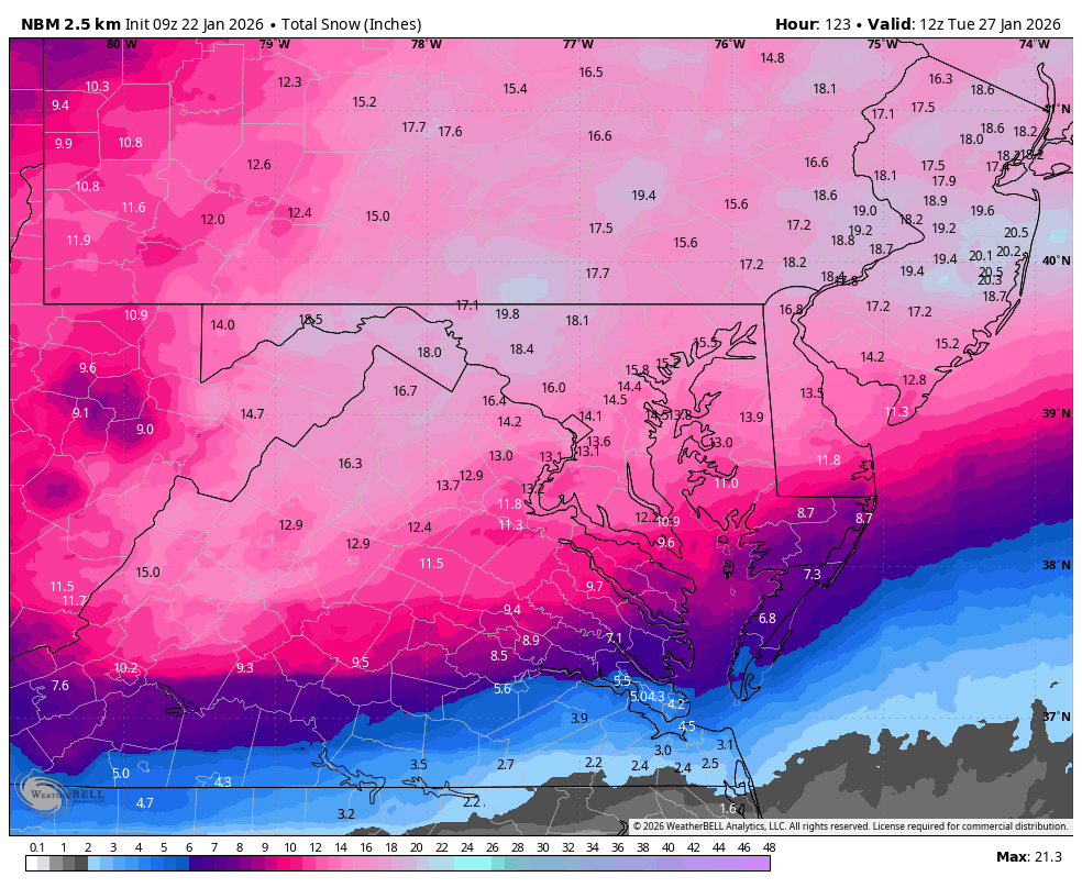
NBM mean on today's 7 UTC run up to 11" even. Spread tightened a little more to 7" to 13" on average. 1 in 3 odds of >12" total. >8" up slightly to 68% chance. Most guidance held, so I guess we're waiting to see if a last minute de-amplification occurs. (As a side note, I see a lot of Kuchera maps, but just be careful about those as they tend to get overdone on totals.) -
It is turning into a traditional cad signature (maybe slightly stronger) that has an eastern edge oriented sw to ne roughly parallel with 85. These events favor a mix for central NC and more rain I95 east. There will be a very large gradient over wake with some parts of wake having the possibility of limited ice. Possibility, not guaranteed at this point. Regardless of the reason whether it is strength of the high or the low scouring out the mid and lower levels, this is not the way central NC gets a big snowstorm. .
-
So close to a foot. But I can accept it.
-
January 24-26: Miracle or Mirage Thread 2
SomeguyfromTakomaPark replied to mappy's topic in Mid Atlantic
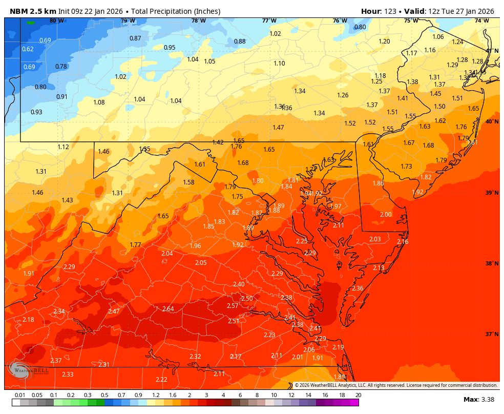
QPF bomb, u love to see it. Let’s get like 1.2 down in dc before the ice. -

Richmond Metro/Hampton Roads Area Discussion
jlewis1111 replied to RIC Airport's topic in Mid Atlantic
-

Possible Record Breaking Cold + Snow Sunday 1/25 - Tuesday 1/27
EasternLI replied to TriPol's topic in New York City Metro
Maybe. Wish more levels were available. Even if that happens the precip is about to shut off anyway I think with a dry slot. We'd have a good dump anyway before that. Still a ways to go with this thing. Should be fun to see what happens. -
WB 9Z NBM

-

Central PA Winter 25/26 Discussion and Obs
mahantango#1 replied to MAG5035's topic in Upstate New York/Pennsylvania
-
06z finally a tick colder on the Euro/Ai/Eps is great to wake up to. Let’s make it a trend.
-
Lulz https://www.wpc.ncep.noaa.gov/discussions/hpcdiscussions.php?disc=qpfhsd 20:1 SLRs in banding Saturday night with hours of 1"+ snow rates
-
Im feeling like probably somewhere in the middle which would still be fantastic.
-
.