All Activity
- Past hour
-
I’m biased but I’m not sure there are many places in the country that have gotten the shaft over 4-5 straight winters the way that region from NE Ga into the Upstate and foothills has. Especially considering there are many locations in there that had never recorded a winter without snow until going multiple years without finally broken by a few inches of wet wintry mix last year. I mean I live at around 2000 feet in the north Ga mountains, yet Albany GA has more snow than me over a 4 year stretch. Unfathomable…. We are due a win.
-

Winter 2025-26 Short Range Discussion
Cary67 replied to SchaumburgStormer's topic in Lakes/Ohio Valley
Only about 0.5-1.0" down here. -

January 2026 regional war/obs/disco thread
weatherwiz replied to Baroclinic Zone's topic in New England
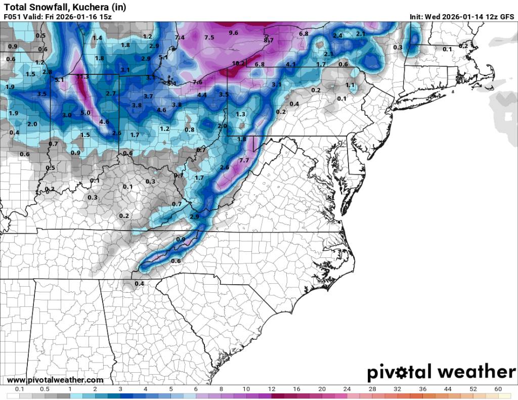
12z GFS looking like a few spots may be able to grab a few inches Saturday too. That is some macho vort -
We are now under a Brine Warning. .
-

January 2026 regional war/obs/disco thread
Typhoon Tip replied to Baroclinic Zone's topic in New England
I just wanna point something out before we move on from the 15/16th in the spirit of philosophy, objectivity and fairness. These storm dates did not fail. What failed was our "regional backyard" ? I get the importance of actually getting it into our backyard - but that is unfortunately a myopic and frankly dim intelligence about the reality we are a part. This is the NAM's 24 hours - I'm just using it to make the point. There is a storm resulting from anticipating amplitude from over a week ago. Meteorologically, this is acceptable, particularly considering that this period was sussed out .. perhaps even 10 days prior. Again, it just ended up in southern Ontario and lower Quebec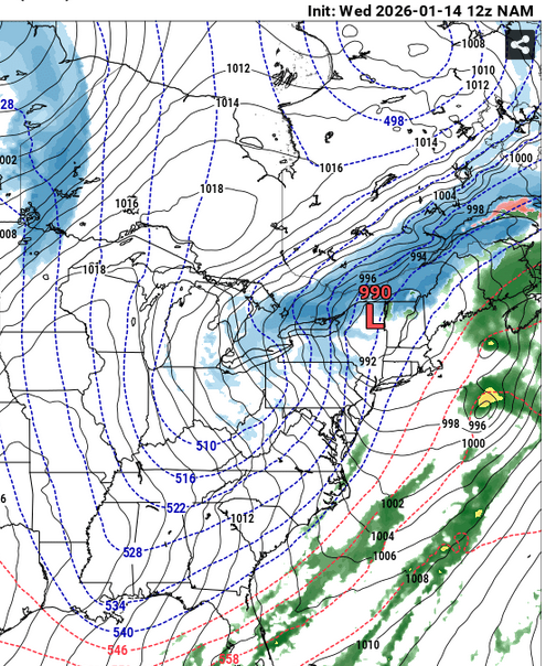
-
12z gfs actually going back to a longer duration event along the border. Sent from my SM-G998U using Tapatalk

-

January 2026 regional war/obs/disco thread
dendrite replied to Baroclinic Zone's topic in New England
In low places? -
12z GFS says, nope, just kidding, not a single flake for us.
-

January 2026 regional war/obs/disco thread
Damage In Tolland replied to Baroclinic Zone's topic in New England
Is that much AN furnace or just mild? -

January 2026 regional war/obs/disco thread
moneypitmike replied to Baroclinic Zone's topic in New England
Just got in from a walk---felt great at 46*. Solid snow-cover will be taking a beating today/tomorrow. -
January 2026 regional war/obs/disco thread
dendrite replied to Baroclinic Zone's topic in New England
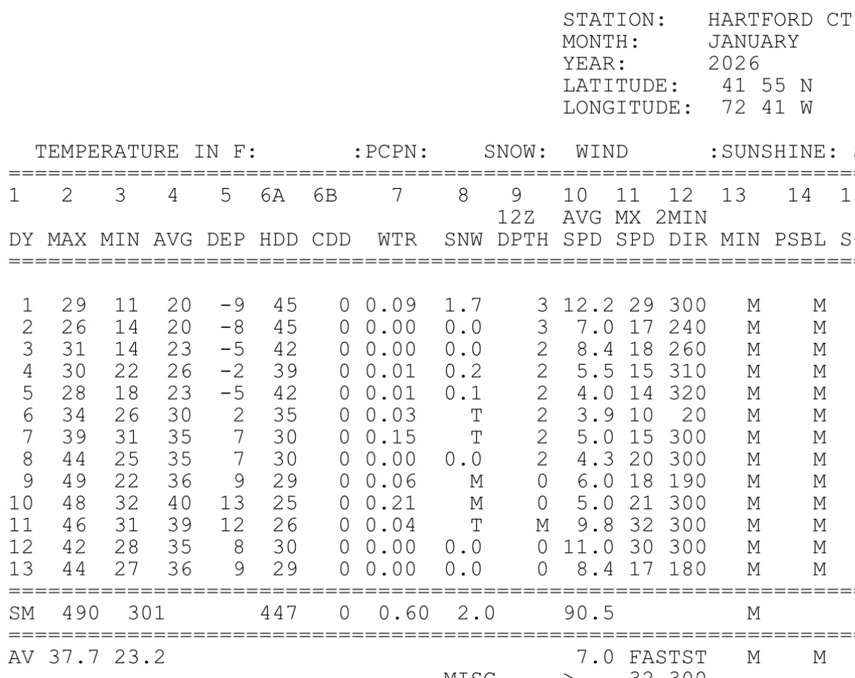
Your one day to break the streak was 38° It’s 7 days straight where most people work and live. +2.7° coming into today for BDL MTD.
-
West again on the gfs. Energy coming into Montana.
-
"Warm up" is doing some heavy lifting here.
-
January 2026 regional war/obs/disco thread
dendrite replied to Baroclinic Zone's topic in New England
Yeah…there’s lot of freezing fog in the valleys and at high elevation making rime ice. Freak and MWN post a lot of epic rime pics. Obviously that’s all supercooled droplets needing a cold surface to freeze/deposit on. I remember Fort Kent Will posting some good true IC pics (maybe vids) awhile back when he still lived up there. -

January 2026 regional war/obs/disco thread
ORH_wxman replied to Baroclinic Zone's topic in New England
Reggie is decent for Saturday PM over a chunk of SNE. Prob 1-2” of paste. It looks very threatening for beyond that but it’s 84 hours on the rgem. -
Agreed.
-

January 2026 regional war/obs/disco thread
CoastalWx replied to Baroclinic Zone's topic in New England
Icon gives some snow ern areas Sunday night -
January 2026 regional war/obs/disco thread
Damage In Tolland replied to Baroclinic Zone's topic in New England
The point is there was no week plus of 50’s and higher like some circles had. There was never a debate that it wasn’t going to go AN for a week or so . The argument was that it wasn’t going to be some all out furnace for 7-11 days . It wasn’t . Just a temporary mild up pattern -
ICON is most similar to Euro. Has moderate snowfall just offshore. Started to look better early on but the trough is still positively tilted. With a positive tilt, it's limited in how far west it can get
-
Kinda of looks like it wants to load up on a little juice before it swings up thru us?
-

January 2026 regional war/obs/disco thread
mahk_webstah replied to Baroclinic Zone's topic in New England
weather weenie is sometimes a literal phrase. -
Yall remember when tomorrow was 5-10" for the area? Good times
-

January 2026 regional war/obs/disco thread
dryslot replied to Baroclinic Zone's topic in New England
Lot more rime ice when your up in the mountains, You can pick out the difference much easier. -

Winter 2025-26 Short Range Discussion
DocATL replied to SchaumburgStormer's topic in Lakes/Ohio Valley
Man, I am some rando that just moved here for work (well this is my wife’s hometown also). I’ve been called worse things. Most of them justified. -
January 2026 regional war/obs/disco thread
ORH_wxman replied to Baroclinic Zone's topic in New England
We used to get fake diamond dust all the time when I was living in Holden in the late 80s. It was really just some crappy snowflakes though which would happen when it got really frigid (usually low single digits or below zero), but not nearly cold enough for true Diamond dust. The house was kind of in an elevated valley around 1,000 feet so it was prob ideal for getting that type of setup.