All Activity
- Past hour
-

E PA/NJ/DE Spring 2026 Obs/Discussion
JTA66 replied to PhiEaglesfan712's topic in Philadelphia Region
Trash night! Has anyone ever conducted a study to see if putting out the garbage cause severe weather? (The same way trailer parks attract tornados?) -
Light rain here now 37/27
-
26.9F Light snow 1/4" Light snow started around 630am. It changed to light sleet for awhile. Then went back to light snow. Bigger flakes an hour ago. Then is basically stopped and I could see south for 25 miles while it was snowing in Plymouth. During the last 10 minutes light snow has resumed, vis about 1 miles but very small flakage.
-
It's hitting Flagstaff the hardest. Their previous highest temp ever recorded in March was 73. They are in the 80s for it looks like 4 days. No UHI cause for this SW warm up.
-
We look good for persistent AN next week as we move to April. MJO phase 1/8 tendency which we’ve had a lot of flips to AN bias in early spring. The EPS is already saying the same. That will feel really nice. A very nice early April for a change.
-
Just you wait until we see a tropical system near the Bay in late July that drops 24"+ snow on us for a cycle or two!!!
-
Hopefully bust number2 this weekend with the rains. Water still pouring out of the hillsides after all the snowmelt and recent heavy rains . The next week looks fairly dry other than a few showers
- Today
-
Yeah not really any basis for the way the last 4-5 months have gone out there. One of the bigger record breaks on record.
-
0z EPS is really warm the 1st week of April. Like 70s to near 80
-
Picking up again, but it’s still refrozen flakes with a sleet-like sound. Radar looks abysmal.
-
Not even a dusting here. Vast majority of people around here won’t know even a flake has fallen. Bust on the advisory…
-
.thumb.jpg.6a4895b2a43f87359e4e7d04a6fa0d14.jpg)
Central PA Spring 2026 Discussion/Obs Thread
Yardstickgozinya replied to Voyager's topic in Upstate New York/Pennsylvania
I would get your cameras ready today, fellas,some of cells are probably going to be quite photogenic compare to what we're used in our area. Especially early in their evolution. I wouldn't be surprised if there's a rare lp supercell or two in cpa today. Spc update last night mentiond two rounds of storms. Round one will be a cellular and probably will remain so for quite some time today with a line of storms possible tonight. Both rounds have potential for large hail. If we can get enough breaks in the sun today, destabilization could generously increase our tornado risk . We also have a week cap in place to help get that gun loaded. All in all today really seems the have a wide spectrum of potential . My guess is, there's going to be one or two epically, nasty cells track through central pennsylvania this afternoon with several other potentially strong to severe storms into the early night time hours. Watch your left cell splits for the big hail today and stay safe. Today, definitely could be our biggest severe day yet in our general area. -
Trying to stay safe

-
1.5” at home so far. Snowing hard. 3” on upper mountain snow cam.
-

Spring 2026 Med/Long Range Discussion
CheeselandSkies replied to Brian D's topic in Lakes/Ohio Valley
Chase tour runs April 3-12! -
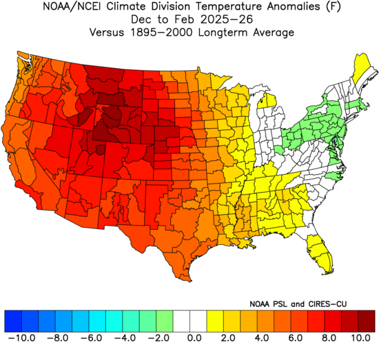
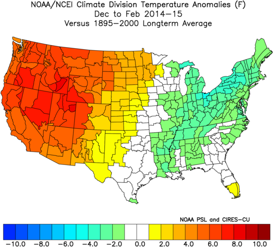
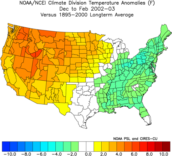
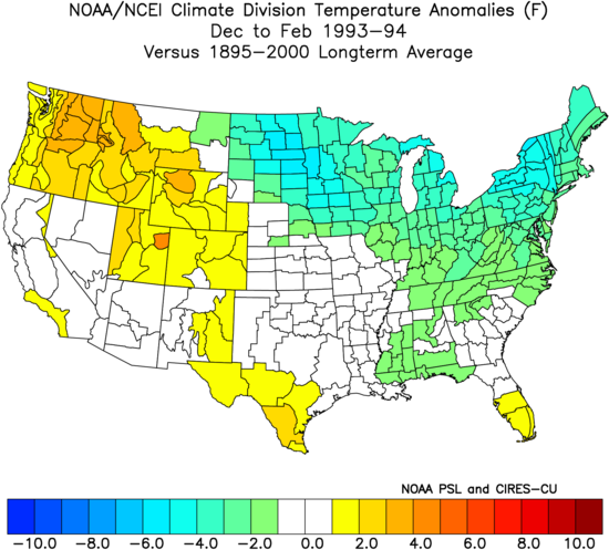
Evolution of winters around 32° and colder in NYC since the 1970s showing the expansion of warmth to our west.
-
Most models are flipping the rain in C/E MA over to snow tomorrow and then swing an inverted trough through during the evening bringing a N-S oriented band of snow.
-
Central PA Spring 2026 Discussion/Obs Thread
Yardstickgozinya replied to Voyager's topic in Upstate New York/Pennsylvania
Nws forcast discussion only concerning today's thunderstorms. Full discussion.is in the link at the bottom. Hazardous Weather Outlook Hazardous Weather Outlook National Weather Service State College PA 348 AM EDT Sun Mar 22 2026 PAZ017>019-024>028-033>036-045-046-049>053-056>059-063>066-230800- Clearfield-Northern Centre-Southern Centre-Cambria-Blair-Huntingdon- Mifflin-Juniata-Somerset-Bedford-Fulton-Franklin-Southern Clinton- Southern Lycoming-Union-Snyder-Montour-Northumberland-Columbia-Perry- Dauphin-Schuylkill-Lebanon-Cumberland-Adams-York-Lancaster- 348 AM EDT Sun Mar 22 2026 This Hazardous Weather Outlook is for central Pennsylvania. .DAY ONE...Today and tonight. Scattered severe thunderstorms with damaging winds 60 mph or greater and large hail exceeding 1 inch in diameter are possible this afternoon and evening. .DAYS TWO THROUGH SEVEN...Monday through Saturday. The probability for widespread hazardous weather is low. .SPOTTER INFORMATION STATEMENT... Spotters are encouraged to report significant hazardous weather. HAS CHANGED... * Little change in Sunday`s severe thunderstorm potential, built out more details pertaining to timing and threats. * Added mentions of icing potential Monday morning with dropping temperatures and freezing rain/drizzle potential across the Poconos. && .KEY MESSAGES... 1) Severe thunderstorms possible this afternoon and evening across much of central Pennsylvania, highest chances south of the I-80 corridor. 2) Some icing potential Sunday night into Monday morning across portions of NE PA, slick spots possible for the Monday morning commute. && .DISCUSSION... KEY MESSAGE 1: Severe thunderstorms possible this afternoon and evening across much of central Pennsylvania, highest chances south of the I-80 corridor. Severe threat will be in play across much of central PA this afternoon and evening, with surface dewpoints across western Indiana surging towards the region. Recent HREF model guidance continues to indicate favorable probabilities (generally between 50-70%) for surface dewpoints reaching into the mid-to-upper 50s this afternoon for regions south of I-80. Bulk wind shear across the entire area by this time will also markedly increase which would support thunderstorm development to become organized enough to sustain themselves this afternoon/evening. There does remain some uncertainty with respect to CAPE with some recent hi-res model guidance indicating some breaks in the clouds across south-central Pennsylvania during the afternoon hours. If these solutions begin to pan out, this will allow for an uptick in instability, which would increase the severe threat. For reference, model solutions on the lower end of CAPE values top out between 500-600 J/kg while higher-end solutions of CAPE values exceed 1000 J/kg and push closer to the 1500 J/kg mark which would be much more sufficient for severe weather potential this afternoon. The spread is most pronounced across western portions of the forecast area, which is where model guidance is the most uncertain with respect to cloud cover later today. All of that being said, SPC has continued with the slight risk for severe thunderstorms this afternoon/evening for areas south of the I-80 corridor. Damaging wind threat continues to highlight areas mainly south of I-80 where there is there remains some higher potential for instability with ample shear in place. Fact cell movement will also give ample convective and kinematic energy to support the damaging wind threat this afternoon and into the evening. The hail threat across the southern half of Pennsylvania bears watching, with steep (7-7.5 C/km) 700-500mb lapse rates continuing to be signaled in recent hi-res model guidance. Large hail will be possible, as SPC outlines with their CIG1 hatching across the southern half of Pennsylvania. These hazards are expected to be focused in the 2PM to 9PM timeframe today, gradually spreading north-to-south throughout the afternoon and evening hours. In terms of the tornado threat across the region, there remains a non-zero threat across portions south of I-80. This threat is not as robust as the wind/hail threat. One of the main negatives with respect to the tornado threat read out in looking at model guidance for LCLs this afternoon. LCLs look to be relatively high with recent RAP model guidance indicating LCLs between 2000-3000m across the southern half of the region. The higher cloud bases will make it slightly harder (not impossible) to form, especially with low-level dry air in place. Lastly, flooding concerns given some locations have pushed slightly above one inch storm total rainfall amounts with more localized pockets of heavy rainfall. Highest rainfall signals appear across the southern tier, where recent Drought Monitor continues with D1-D2 drought. FFGs in this area would likely need to be exceeded in the one-hour timeframe, where we`re looking at slightly below one inch to exceed guidance. Given this, not foreseeing a lot of hydrological issues with this system especially given quick movement of storms. https://forecast.weather.gov/product.php?site=CTP&issuedby=CTP&product=AFD&format=CI&version=1&glossary=1&highlight=off -
Barely. 31.0° -SN Just a dusting so far. It almost looks mixy at times…hard to tell in the early light. The flakes are heavily rimed though.
-
Happy to say no snow here, though it probably is snowing at Brian’s
-

Central PA Spring 2026 Discussion/Obs Thread
Voyager replied to Voyager's topic in Upstate New York/Pennsylvania
The last part of this post is where the truth lies. -
31 with light snow
-
How has their urban development gone recently? Any population explosions to cause this?
-
Morning day 1 from SPC
- 266 replies
-
- 1
-

-
- severe
- thunderstorms
- (and 7 more)