All Activity
- Past hour
-

December 2025 regional war/obs/disco thread
mahk_webstah replied to Torch Tiger's topic in New England
My favorite when there is a snowpack. Refresher, brief heavy snow and wind and fresh cold -

First Winter Storm to kickoff 2025-26 Winter season
ORH_wxman replied to Baroclinic Zone's topic in New England
NAM coming in a little flatter so far than 12z -

12/3 Snow/Sleet/Mix Bag of Everything Discussion/OBS
RedSky replied to Mikeymac5306's topic in Philadelphia Region
URGENT - WINTER WEATHER MESSAGE National Weather Service Mount Holly NJ 111 PM EST Mon Dec 1 2025 NJZ009-PAZ101-103-105-020900- /O.CON.KPHI.WW.Y.0013.251202T0900Z-251202T1500Z/ Hunterdon-Western Chester-Western Montgomery-Upper Bucks- Including the cities of Perkasie, Collegeville, Pottstown, Honey Brook, Flemington, Oxford, and Chalfont 111 PM EST Mon Dec 1 2025 ...WINTER WEATHER ADVISORY REMAINS IN EFFECT FROM 4 AM TO 10 AM EST TUESDAY... * WHAT...Mixed precipitation expected. Total snow and sleet accumulations up to one inch and ice accumulations around a light glaze. * WHERE...In New Jersey, Hunterdon County. In Pennsylvania, Upper Bucks, Western Chester, and Western Montgomery Counties. * WHEN...From 4 AM to 10 AM EST Tuesday. -
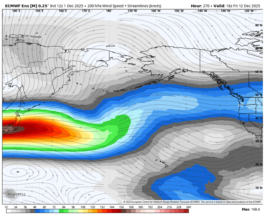
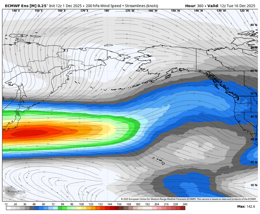
I think it’s a downstream consequence of re-establishing the equatorward pacific jet and rebuilding the -EPO.
-
First Winter Storm to kickoff 2025-26 Winter season
mahk_webstah replied to Baroclinic Zone's topic in New England
I can see it from my window -

First Winter Storm to kickoff 2025-26 Winter season
Boston Bulldog replied to Baroclinic Zone's topic in New England
If the band orients WSW-ENE through you and Dendrite, would have to think the summit of Kearsarge could be our jack -

December 2025 regional war/obs/disco thread
WinterWolf replied to Torch Tiger's topic in New England
Good to know…we’ll see if that comes to fruition…or not? -

12/3 Snow/Sleet/Mix Bag of Everything Discussion/OBS
zenmsav6810 replied to Mikeymac5306's topic in Philadelphia Region
Lol. My forecast is a "wet dusting". I must say social media is over run with a plethora of "weather authority" vendors these days- and most of them are posting absolute swap these days. Any body with a computer and a map is putting out snow maps these days! I'm sure AI isnt helping with that -

First Winter Storm to kickoff 2025-26 Winter season
met_fan replied to Baroclinic Zone's topic in New England
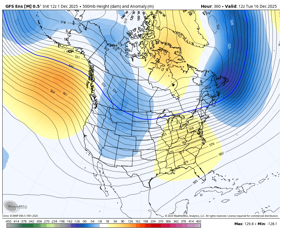
The second one is the current map -

December 2025 regional war/obs/disco thread
Typhoon Tip replied to Torch Tiger's topic in New England
I realize the following comment's likely to catapult me into the top ranked popularity seeding but ... winter sputters in January this year. Possibly early on too. Canonical thaw struggles to reset and then its flower February -
I get why you're thinking maybe a relaxation after the 15th. However, I think the MJO in cold Phase along with possible upstream blocking should curtail any significant warmup mid late month. If anything, may get a deeper dive of the PJ and Cold. The PAC Jet may try to mitigate the Effects of the above mentioned as it may dampen the -EPO but, the MJO and -NAO should still keep troughing in the East. Just my Antique 2 Cents worth. Of course, if the -NAO is not still there or robust then a milder outcome.
-
lol Judah
-

First Winter Storm to kickoff 2025-26 Winter season
Colonel Badger replied to Baroclinic Zone's topic in New England
Interesting that I'm under a WSW and the NWS map has 7", when the Meso models are basically rain. -

Central PA Fall Discussions and Obs
Itstrainingtime replied to ChescoWx's topic in Upstate New York/Pennsylvania
It better thump from the onset. Otherwise, even these numbers might not materialize. -
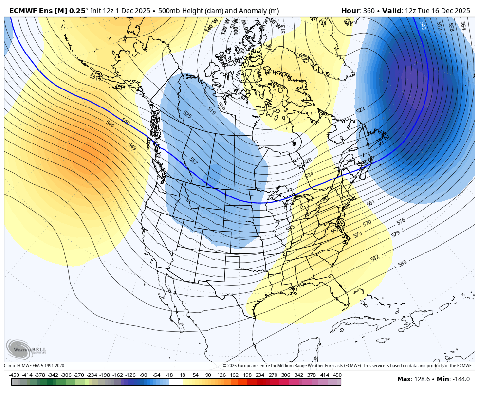
I was expecting a mid-month warmup, but that's looking more and more temporary.
-
First Winter Storm to kickoff 2025-26 Winter season
mahk_webstah replied to Baroclinic Zone's topic in New England
My zones add up to 7-13 and Elster has increased total expected to 10 for CON. We are prob gonna get that band -
Central PA Fall Discussions and Obs
Itstrainingtime replied to ChescoWx's topic in Upstate New York/Pennsylvania
-

2025-2026 Fall/Winter Mountain Thread
Maggie Valley Steve replied to Buckethead's topic in Southeastern States
It's going to be a close call here in Haywood County overnight. I see GSP has issued a Winter Weather Advisory for Buncombe and Henderson Counties now. Frankly the models are struggling beyond 24 to 48 hours. Until they settle down, it's hard to put much faith in the medium and longer range guidance. -

Central PA Fall Discussions and Obs
Mount Joy Snowman replied to ChescoWx's topic in Upstate New York/Pennsylvania
The rain line sneaking north -- a tale as old as time. NWS's latest map..... -
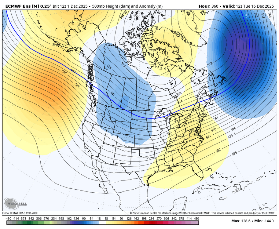
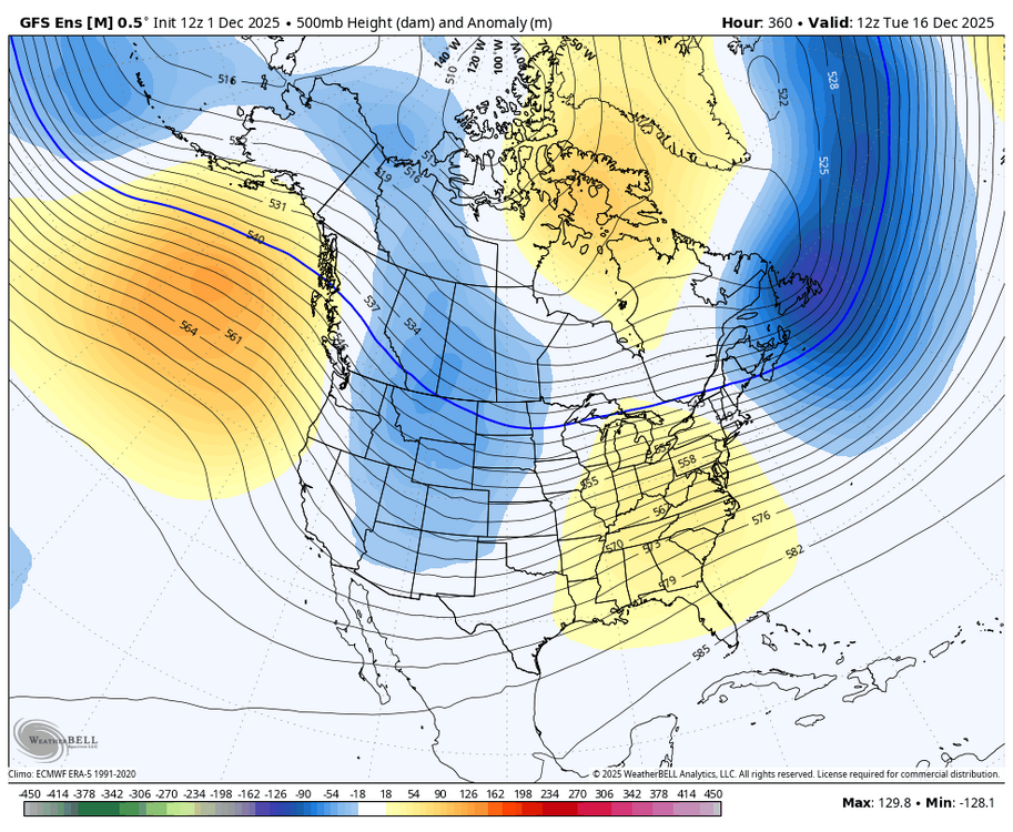
The AK vortex is there for only 5 days (days 5-10) after which it’s pushed well inland. By day 15, it’s way different per 12Z ens: 12Z GEFS: 12Z EPS:
-
Rt 15 special incoming
-
Agree. Weak PV from Strat probably part of it. Ryan Maue thinks a full Split is still coming. Also, if the blocking upstream Models are suggesting coming up is right then there will probably be a deeper dive of the Cold into the SE than being shown.
-
Just got a workout in and it’s definitely anti-torch outside, unlike in March when we’d easily blast into the upper 40s/low 50s. I’m becoming more bullish. My bar is an inch on all elevated surfaces.
-
Wouldn't be bad for a good chunk of ya'll. Wish our favored friends the best!
-
What could go wrong using terms like "most extreme" and "shocking"!