All Activity
- Past hour
-

Wounded Duck Strikes Back: Dec 26 & 27th Winter Storm Obs
moneypitmike replied to WxWatcher007's topic in New England
My wife is reporting 2” in PVD. Spotter reports are all 3 or more. i always tell her things are bigger than she thinks they are. -

Boxing Night Snow/Sleet/Ice Dec 26-27 Storm Thread/Obs.
RU848789 replied to Mikeymac5306's topic in Philadelphia Region
Well whaddya know? We got another 0.3" since 3 am, bringing my total to 2.1", which somehow sounds like less of a bust than 1.8", lol. Woke up once and saw some light snow and looking at the radar since 3 am I can definitely see another 0.3" (looks like it should've been more, but that's what I measured). Snowing very lightly now at 25F. Reports of 4-7" on LI, 3-5" for most of NYC including 4.3" in Central Park, breaking their almost 4 year streak without a 4"+ storm (last storm over 4" was 8.3" on 1/28/22, although everyone says they've undermeasured a few times - there's a whole cottage industry on critiquing CPK's snowfall measurements, lol), 3-5" in NENJ (Union up to Bergen), including 4.2" at EWR. However, I'm not sure anywhere else in NNJ or CNJ got over 3", especially S of 78, apart from NE Middlesex County, as it's the furthest NE part of the NWS-Philly counties; saw a report of 3.2" from Carteret, which is ~8 miles NE of me and reports of 3+" in southern SI, which is 7-8 miles E of me and being NE definitely made a difference. -
The low at 700mb passed north of Lake Ontario. The surface reflection was in NEPA or WNY. There definitely was a dry slot visible on radar/satellite yesterday evening associated with this shortwave in WNY that pushed through the southern tier of NY. As the "primary" weakened and began to redevelop further south, this dry slot began to fill as well. Clearly the best dynamics were north and east of the NJ-NY border. The NAM showed this very well yesterday morning. All other guidance missed how far north (into NY) the surface low would track and how long the mid-level lows would stay defined. That led to the meat of the precipitation arcing from Long ISland, through CT, to ENY. South of that, the combination of spotty precipitation and a warm tongue near 700mb significantly decreased snow totals. Great job by the NAM IMO.
-

Central PA Winter 25/26 Discussion and Obs
anotherman replied to MAG5035's topic in Upstate New York/Pennsylvania
-
I had heavy rates overnight here in Brooklyn. Ocean effect snow is pretty cool.
-

January 2026 regional war/obs/disco thread
ORH_wxman replied to Baroclinic Zone's topic in New England
Lock in big miller B for that 1/5-1/6 signal. -
If @ORH_wxmanand @psuhoffmanare intrigued, that's good enough for me.
-

Central PA Winter 25/26 Discussion and Obs
canderson replied to MAG5035's topic in Upstate New York/Pennsylvania
Turning Point -

Wounded Duck Strikes Back: Dec 26 & 27th Winter Storm Obs
bristolri_wx replied to WxWatcher007's topic in New England
The Mt. Bristol stake reads… (drumroll) 4” Cloudy with flurries here now. 22.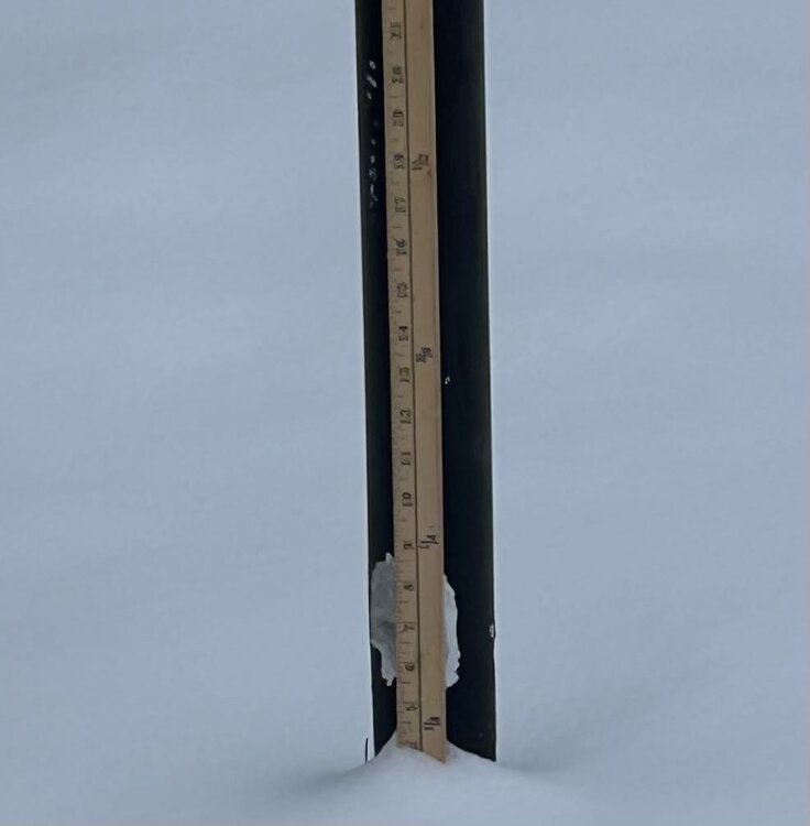

-

January 2026 regional war/obs/disco thread
CoastalWx replied to Baroclinic Zone's topic in New England
St John. Leaving the 31. Hopefully not missing much. -
Nearly 4.5" OTG here in HPN, currently 24F here.
-

December 2025 regional war/obs/disco thread
Damage In Tolland replied to Torch Tiger's topic in New England
https://x.com/ryanhanrahan/status/2004918963705200751?s=46&t=dhcbvkjmRcyBVQtDxJ3lRg -
We picked up an additional 1.7" of all snow overnight from the back filling that Walt and a few others correctly mentioned, bringing storm total to 2.5". Certainly, not a typical scenario, but it worked out enough. I still didn't reach the low end of predictions, although might have if not for the sleet storm at the onset. All in all this wasn't an epic bust, and it certainly did work out for many other locations. It was still flurrying here as of fifteen minutes ago, but looks to be starting to clear up now.
-
January 2026 regional war/obs/disco thread
ORH_wxman replied to Baroclinic Zone's topic in New England
Where you going? -

Central PA Winter 25/26 Discussion and Obs
Jns2183 replied to MAG5035's topic in Upstate New York/Pennsylvania
Where did you go? Sent from my SM-S731U using Tapatalk -
Past history says we're due. The winter of 25/26 has a nice tone.
-
January 2026 regional war/obs/disco thread
Damage In Tolland replied to Baroclinic Zone's topic in New England
We all sell -

Wounded Duck Strikes Back: Dec 26 & 27th Winter Storm Obs
rimetree replied to WxWatcher007's topic in New England
1" this morning and some light snow falling. Nickel and dimes to about average for December...will take it. 15/9 -
January 2026 regional war/obs/disco thread
CoastalWx replied to Baroclinic Zone's topic in New England
Yep -

Wounded Duck Strikes Back: Dec 26 & 27th Winter Storm Obs
The 4 Seasons replied to WxWatcher007's topic in New England
7.3" here and 7.3" at 2NW Hamden, so id go with that. -
January 2026 regional war/obs/disco thread
Damage In Tolland replied to Baroclinic Zone's topic in New England
I know someone who thinks 50 and rain Monday -
Wounded Duck Strikes Back: Dec 26 & 27th Winter Storm Obs
moneypitmike replied to WxWatcher007's topic in New England
Nice. My clouds arrived just as forecasted. -

Wounded Duck Strikes Back: Dec 26 & 27th Winter Storm Obs
Fozz replied to WxWatcher007's topic in New England
Ended up with 3.8” and still getting flurries. A very wintry morning and the biggest event to date. -
Still snowing here
-

Wounded Duck Strikes Back: Dec 26 & 27th Winter Storm Obs
DavisStraight replied to WxWatcher007's topic in New England
I got an inch here too, one last decent band pivoted over SE Maine towards the end, put a nice fresh coat on the crusty snow we had.


