All Activity
- Past hour
-

Central PA Winter 25/26 Discussion and Obs
Mount Joy Snowman replied to MAG5035's topic in Upstate New York/Pennsylvania
Yeah, as I tell my toddler, "Go to your room and recharge your batteries." Professional mets can't be howling about the inconsistencies of the various models; leave that for us amateurs ha. -
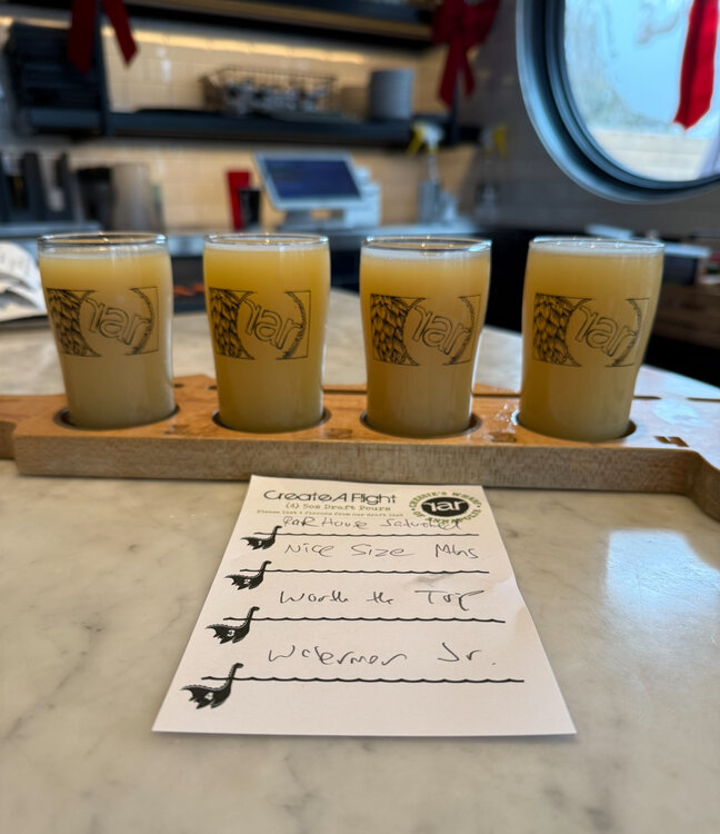
Here’s the latest Untappd snow forecast model. Hop Saturated Snow for the win!
-

White Christmas Miracle? December 23-24th
moneypitmike replied to Baroclinic Zone's topic in New England
Fun times. .NEAR TERM /THROUGH TONIGHT/... Christmas comes early for snow lovers as a Norlun trough impacts Maine and New Hampshire tonight. Snow continues to spread from west to east during the late afternoon and evening hours. By late this evening and through the overnight hours, an inverted trough is expected to become stationary across the MidCoast, likely reaching westward into Casco Bay. This serves as a focus for heavy snowfall overnight, with high ratios and ideal dendritic growth conditions supporting higher snow totals. With this update, confidence has increased in much of the MidCoast experiencing the heavy snowfall, which likely reaches into the western Maine mountains and into the eastern Whites. Winter storms warnings have been expanded another tier of zones inland, where high ratios should help support higher totals. Closer to the coast, high ratio and fluffy snow is still expected, but surface temperatures around freezing likely cause the snow to become a bit stickier and settle more once it`s on the ground. In all these areas, 6-12 inches of snow is expected. Locally higher amounts are possible, and would most likely occur just back from the coast where surface temps in the 20s limit settling, and in areas of increased elevations, even if only by a few hundred feet. The heaviest snowfall rates are expected through the overnight hours, with 1-3 in/hr at times in the heavier snow bands. Reduced visibility and difficult travel conditions are expected overnight. && .SHORT TERM /WEDNESDAY THROUGH WEDNESDAY NIGHT/... Snow continues into the morning hours through much of Maine. Heavy snowfall rates of 1-3 in/hr continue into the early morning commute along the coast, and then ease through the late morning and early afternoon hours. Winds increase toward the end of the snowfall event, with gusts of 20-30 mph likely to cause some blowing and drifting snow into the afternoon hours tomorrow. Temperatures also fall on the backside of the system, with temps spending most of the day in the 20s. Temperatures fall into the teens across most of the region for Christmas Eve. Then, clouds begin to move in overnight as the next shortwave moves in on northwesterly flow. Snow showers spread southeastward after midnight, likely reaching into central locations by daybreak on Christmas morning. Snowfall amounts from this would remain light, but a coating to an inch of snow is possible by daybreak across the mountains and foothills. -

White Christmas Miracle? December 23-24th
Damage In Tolland replied to Baroclinic Zone's topic in New England
32 here and sticking except road . Intensity picked up last 15 minutes -

2025-2026 ENSO
Stormchaserchuck1 replied to 40/70 Benchmark's topic in Weather Forecasting and Discussion
Yeah everything bought into the warm pattern real quick as NG was forecasting the pattern to basically last all Winter. It's not a wall-to-wall torch pattern this Winter, imo. -

December 2025 Short/Medium Range Forecast Thread
Matthew70 replied to John1122's topic in Tennessee Valley
Let’s keep the mojo going!!! -

December 2025 regional war/obs/disco thread
Snowcrazed71 replied to Torch Tiger's topic in New England
We actually had a storm back in I think 2020 .. December I believe. We had at least a few inches of sleet during the day and later that night I remember we had thunder and lightning and everything turned to Snow.... By the next day when it stopped in the early afternoon, we had about 16 or so inches. -
just had a nice burst of snow, too bad temps are marginal everything that fell and falling is melting.
-

Central PA Winter 25/26 Discussion and Obs
canderson replied to MAG5035's topic in Upstate New York/Pennsylvania
You very well know this region can’t all cash it together lol But man it’d be awesome if that comes to fruition. No ice!!! -
2025-2026 ENSO
Stormchaserchuck1 replied to 40/70 Benchmark's topic in Weather Forecasting and Discussion
We are getting a 5850dm block between England and Iceland in a few days.. a +600dm anomaly. This will be the 2nd +600dm anomaly in a few days, as we just had one over the Aleutian islands. It's an east-based -NAO. See how the late November Stratosphere warming correlates to -NAO in about +30-35 days?? I went all the way back to 1948 and found that pattern with a different lag time at different times of the cold season. But this is a major hit. Models didn't pick it up until the last few days.. it will be interesting to see if it's a common bias if an early Winter Stratosphere warming happens again in the next few years. -
I’ll take 1 the 40% chance ain’t good enough for me
-
Natural gas is now up 10% due to the models’ much colder late Dec and now early Jan vs what last week’s models showed! If this holds, it would easily be the strongest single day since at least August. Keep in mind that NG’s strongest days are usually when the E US two week forecast is looking colder than the prior day: Natural Gas (NGF6) Real-time derived Currency in USD 4.376 +0.411(+10.37%) Real-time Data·13:51:34
-
December 2025 regional war/obs/disco thread
Snowcrazed71 replied to Torch Tiger's topic in New England
We'll see about the Friday/Saturday deal. The one Brooklyn is posting about is New Year's Day. -

December 2025 regional war/obs/disco thread
weatherwiz replied to Torch Tiger's topic in New England
It probably is a result of smoothing and averaging, but that would be something pretty damn good to work with...if we got the TPV to dig exactly as shown. There really is no way to see each member, is there? The OP doesn't dig as aggressively and we would probably need to see the OP more in line of the ENS to really make this potentially noteworthy. I'd be curious to know where each member stands -
This weather sucks…
-
White Christmas Miracle? December 23-24th
moneypitmike replied to Baroclinic Zone's topic in New England
Just noticed they expanded the warning area. And put out a new map. Well done! -
I can't remember what year, 92/93 maybe, we had a solid sleet storm with inches of it, I remember driving around like a fool with like 3-4" of sleet, crazy time. But it was early 90s, I thought 93/94 was the really cold year, no? perhaps it was that year.
-
White Christmas Miracle? December 23-24th
moneypitmike replied to Baroclinic Zone's topic in New England
GYX has upped my p/c Afternoon Snow likely, mainly after 5pm. Cloudy, with a high near 32. East wind around 5 mph. Chance of precipitation is 60%. Total daytime snow accumulation of less than one inch possible. Tonight Snow. The snow could be heavy at times. Low around 27. East wind 5 to 10 mph. Chance of precipitation is 100%. New snow accumulation of 6 to 10 inches possible. Wednesday Snow, mainly before noon. High near 30. North wind 5 to 15 mph, with gusts as high as 25 mph. Chance of precipitation is 90%. New snow accumulation of 2 to 4 inches possible. -
White Christmas Miracle? December 23-24th
moneypitmike replied to Baroclinic Zone's topic in New England
Looking and feeling like snow now. -
2
-

2025-2026 ENSO
TheClimateChanger replied to 40/70 Benchmark's topic in Weather Forecasting and Discussion
Whoa. What is going on in Pennsylvania and New York on Friday? -
This will gradually evolve toward more snow. That nw to se alignment is indicative of a high being east of Maine like the other moderate snow maker we had. I’m thinking that high will be more over Maine. The low then is more along TN/KY line and further enough south to not let warm air override us so much
-
Once that trough axis moves to just west of us, crazy things can start to happen... watch out for some trackable events then.
-
 1.8"
1.8" -

Winter cancelled/uncancelled banter 25/26
coastalplainsnowman replied to Rjay's topic in New York City Metro
The recent and upcoming weather has got me thinking. Which of the following scenarios do you prefer: 1. Experiencing a 3-6" snowstorm right now, knowing it is going to be washed away by a rainstorm in 48 hours 2. Experiencing a dreary, misty damp day right now, but there's a 40% chance of 6-8" in 48 hours


